एल्बानी, न्यु यर्क
Appearance
| एल्बानी, न्यु यर्क | |||
| City | |||
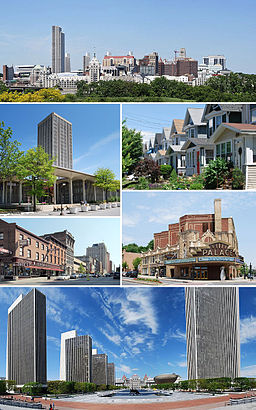
Clockwise from top: Albany skyline from Rensselaer; middle-class housing in the Helderberg neighborhood; Palace Theatre; Empire State Plaza from the Cultural Education Center; North Pearl Street at Columbia Street; and the State Quad at SUNY Albany.
| |||
|
|
|||
| Name origin: स्कतिश द्युक अफ एल्बानीया नामं छुगु नां, एल्बानी पदवी स्कतल्यान्दया गेलिक नां : एल्बानं वःगु ख | |||
| Motto: Assiduity | |||
| Country | संयुक्त राज्य अमेरिका | ||
|---|---|---|---|
| State | न्यु यर्क | ||
| Region | Capital District | ||
| County | Albany | ||
| Landmark | Empire State Plaza | ||
| River | Hudson | ||
| Coordinates | 42°39′9.34″N 73°45′26.33″W / 42.6525944°N 73.7573139°W | ||
| Highest point | Unnamed hill | ||
| - elevation | ३२४ ft (९९ m) | ||
| - coordinates | 42°43′13.24″N 73°52′2.15″W / 42.7203444°N 73.8672639°W | ||
| Lowest point | Sea level (at the Hudson River) | ||
| - elevation | ० ft (० m) | ||
| Area | २१.८ sq mi (५६ km²) | ||
| - land | २१.४ sq mi (५५ km²) | ||
| - water | ०.४ sq mi (१ km²) | ||
| - metro | ६,५७० sq mi (१७,०१६ km²) | ||
| Population | ९७,८५६ (2010) | ||
| - metro | ८७०,७१६ | ||
| Density | ५,४८८.१ / sq mi (२,११९ / km2) | ||
| Settled | 1614 | ||
| Incorporation as city | 1686 | ||
| Government | Albany City Hall | ||
| - location | 24 Eagle Street | ||
| - coordinates | 42°39′6″N 73°45′16″W / 42.65167°N 73.75444°W | ||
| Mayor | Gerald Jennings (D) | ||
| Timezone | Eastern (EST) (UTC-5) | ||
| - summer (DST) | EDT (UTC-4) | ||
| ZIP Code | 12201-12, 12214, 12220, 12222-32 | ||
| Area code | 518 | ||
| FIPS code | 36-01000 | ||
| GNIS feature ID | 0977310 | ||
| Demonym | Albanian | ||
|
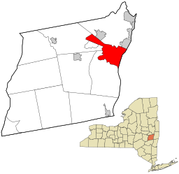
Location of Albany within Albany County and New York State
| |||
| Website: albanyny.org/ | |||
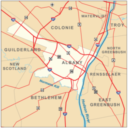
एल्बानी संयुक्त राज्य अमेरिकाया न्यु यर्क राज्यया राजधानी ख। नापं, थ्व नगर एल्बानी काउन्तिया मुख्यालय नं ख। थ्व नगर न्यु यर्क सिति स्वया करिब १४० माइल उत्तरय् ला। एल्बानी हद्सन खुसिया सिथय् मोहःक खुसि स्वया करिब १० माइल दक्षिणय् ला। सन् २०१०या तथ्याङ्क कथं थ्व नगरया सकल जनसंख्या ९७,८५६ दु। एल्बानीया नापं दूगु नगर त्रोय, Schenectady, व Saratoga Springs, नाप एल्बानीया क्वातुगु स्वापू दु। थ्व नगरत नापं जाना एल्बानीं क्यापितल दिस्त्रिक्त धाःगु क्षेत्र दयेकु। थ्व क्षेत्रया मू लागा Albany-Schenectady-Troy महानगर क्षेत्रय् ला। थ्व महानगरया सन् २०१०या जनसंख्या ८,७०,७१६ दु। थ्व जनसंख्या न्यु यर्कया ४गु दकलय् अप्वगु व संरा अमेरिकाया ५८गु दकलय् अप्वगु नगरी जनसंख्या ख। [१]
लिधंसा
[सम्पादन]- ↑ United States Census Bureau, in World Almanac and Book of Facts 2012, p. 612. Largest U.S Metropolitan Areas by Population, 1990-2010.
स्वयादिसँ
[सम्पादन]| विकिमिडिया मंका य् थ्व विषय नाप स्वापु दुगु मिडिया दु: Albany, New York |


