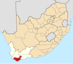
Swellendam
Appearance
| Swellendam | |
|---|---|
 Swellendam with the Langeberg in the background | |
| Coordinates: 34°2′S 20°26′E / 34.033°S 20.433°E | |
| Naga | Afrika Borwa |
| Porofense | Kapa Bodikela |
| Mmasepala wa Selete | Overberg |
| Mmušôselegae | Swellendam |
| Hlômile | 1746[1] |
| Sekgôba[2] | |
| • Total | 58.14 km2 (22.45 sq mi) |
| Setšhaba (2011)[2] | |
| • Total | 17,537 |
| • Phitlaganyo | 300/km2 (780/sq mi) |
| Dipersente tša merafe (2011)[2] | |
| • Bathobaso | 15.4% |
| • Bammala | 63.1% |
| • MaIndia | 0.3% |
| • Makgowa | 19.5% |
| • Šele | 1.8% |
| Dipolelo tša ntlha (2011)[2] | |
| • Afrikaans | 81.3% |
| • Sethosa | 9.5% |
| • Seisimane | 4.8% |
| • Sesotho | 1.1% |
| • Šele | 3.4% |
| Nomoro ya poso (Setarata) | 6740 |
| Nomoro ya poso (Lepokisi) | 6740 |
| Khoutu ya lefelo | 028 |

Swellendam ke toropo kgolo wa Overberg go feta Kapa Bodikela ka moka Afrika Borwa.
Ditšhupetšo
[lokiša | edit source]- ↑ "Chronological order of town establishment in South Africa based on Floyd (1960:20–26)" (PDF). pp. xlv–lii. Archived from the original (PDF) on 2019-07-13. Retrieved 2016-04-01.
- ↑ 2.0 2.1 2.2 2.3 "Main Place Swellendam". Census 2011.
Municipalities and communities of Mmasepala Setereke tša Overberg, Kapa Bodikela | ||
|---|---|---|
| District seat: Bredasdorp | ||
| Cape Agulhas | Arniston • Bredasdorp • Elim • L'Agulhas • Napier • Skipskop • Struisbaai • Suiderstrand |  |
| Overstrand | Baardskeerdersbos • Betty's Bay • Birkenhead • De Kelders • Fisherhaven • Franskraalstrand • Gansbaai • Hawston • Hermanus • Kleinbaai • Kleinmond • Onrusrivier • Pearly Beach • Pringle Bay • Rooi-Els • Sandbaai • Stanford • Van Dyks Bay • Vermont • Zwelihle | |
| Swellendam | Barrydale • Infanta • Malgas • Suurbraak • Swellendam | |
| Theewaterskloof | Botrivier • Caledon • Dennehof • Genadendal • Grabouw • Greyton • Riviersonderend • Villiersdorp | |

