- Thunder Bay, Ontario
Kelsey Pennanen
University of Calgary, Anthropology and Archaeology, Graduate Student
- Lakehead University, Anthropology, Undergraduateadd
- Anthropology, Archaeology, Paleoindians, Lithic Technology (Archaeology), Boreal forest Archaeology, Paleoindian archaeology, and 9 moreGeoarchaeology, Sedimentology, Archeological Prospection, Magnetometry, Archaeological Geophysics, Arctic and Subarctic hunter-gatherers, Remote Sensing, Remote sensing and GIS, Terrestrial Laser Scanning (TLS), and Digital Photogrammetry applied to Archaeologyedit
- Current PhD student in archaeology studying digital platforms for documenting ice-patch sites in Yukon Territory. Ge... moreCurrent PhD student in archaeology studying digital platforms for documenting ice-patch sites in Yukon Territory. General interests in the Scholarship of Teaching and Learning in Archaeology, Digital Heritage Management, archaeological geophysical exploration, and remote sensing. BSc (Honors) Geoarchaeology from Lakehead University in Thunder Bay, Ontario, Canada with research involving sedimentological analyses of post-glacial shorelines along the north shore of Lake Superior. Masters of Arts in Archaeology from the University of Calgary in Alberta, Canada researching the utilization of Terrestrial Laser Scanning (ground-based LiDAR) for monitoring erosion at a bison jump site in the Plains.edit
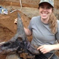
The research presented outlines the use of terrestrial laser scanning as a method of digitally capturing an at-risk Buffalo Jump site in south-central Alberta. The bison faunal material and other archaeological remains present at the base... more
The research presented outlines the use of terrestrial laser scanning as a method of digitally capturing an at-risk Buffalo Jump site in south-central Alberta. The bison faunal material and other archaeological remains present at the base of the sandstone cliff were exposed following the 2013 flooding and migration of the main channel of the Jumpingpound Creek, and the remnant portion of the site is classified as highly threatened due to natural erosional processes along the riverbank. Terrestrial LiDAR was implemented to digitally capture the site and surrounding landscape in the fall of 2016, and a second point cloud dataset was collected in the fall of 2017. Results of the cloud-to-cloud comparison of the two non-contemporaneously collected datasets determined that in certain areas along the cutbank of the site locality, over 1.5 meters of erosion took place. Measurements of the sedimentary cutbank and geologic profiling were recovered from the 3-dimensional spatial data collected and comparisons were made for determinations of cutbank undercutting and instability at different locations based on the point-cloud data. This research will allow for more strategic mitigative archaeological initiatives to be implemented at this site of significant traditional provenance for the Blackfoot peoples to aid in its protection and preservation. TLS implementation creates accurate 3D visualization of archaeological sites it is argued that the analytical possibilities of point clouds and other forms of digital data require further exploration for potential applications in monitoring and use of these datasets for public outreach and sharing of cultural heritage resources. The resulting datasets provide a lasting digital record of the site, at multiple points in time, and the importance of properly archiving datasets for sharing and data compatibility for future use in monitoring is a necessity. As natural disasters such as flooding and wildfire increase in frequency, it is concluded that reality-capture technologies, such as TLS, are effective tools for sharing, documenting, and monitoring heritage resources.
Research Interests:
A thick sequence of sediments exposed by the McIntyre River on the property of Confederation College (Thunder Bay, Ontario) provides important new insight into early Holocene water level changes and paleovegetation in the Superior basin.... more
A thick sequence of sediments exposed by the McIntyre River on the property of Confederation College (Thunder Bay, Ontario) provides important new insight into early Holocene water level changes and paleovegetation in the Superior basin. Basal sediments include rhythmically laminated couplets (interpreted as varves) interbedded between two organic layers dating to 8030+/-30 and 7900+/-30 14C BP. This sequence provides evidence of large-magnitude fluctuations in the base level of Lake Superior at approximately 8900 cal BP due to a combination of climate change and meltwater influx. The sequence has been interpreted as belonging to deposition in a lagoonal setting and provides insight into the environment of peoples inhabiting the area at this time. Plant macrofossil analysis of the organics enables reconstruction of early boreal plant communities established in the Thunder Bay region after deglaciation. The deposits depict a combination lowland boreal forest as well as wetland environment, followed by a transgressive shoreface sequence of a freshwater lagoon.
Research Interests:
The research presented outlines the use of terrestrial laser scanning as a method of digitally capturing an at-risk Buffalo Jump site in south-central Alberta. The bison faunal material and other archaeological remains present at the base... more
The research presented outlines the use of terrestrial laser scanning as a method of digitally capturing an at-risk Buffalo Jump site in south-central Alberta. The bison faunal material and other archaeological remains present at the base of the sandstone cliff were exposed following the 2013 flooding and migration of the main channel of the Jumping Pound Creek, and the remnant portion of the site is classified as highly threatened due to natural erosional processes along the riverbank. Terrestrial LiDAR was implemented to digitally capture the site and surrounding landscape in the fall of 2016, and a second point cloud dataset was collected in the fall of 2017. Results of the cloud-to-cloud comparison of the two non-contemporaneously collected datasets determined that in certain areas along the cutbank of the site locality over 1.5 meters of erosion took place. Measurements of the sedimentary cutbank and geologic profiling were recovered from the 3-dimensional spatial data collecte...
Research Interests:
The Houghton phase was a brief period of low water in the glacial Lake Minong (ancestral Lake Superior) basin during the early-mid Holocene. Previous lake-level reconstructions link the onset of the Houghton phase to the cessation of... more
The Houghton phase was a brief period of low water in the glacial Lake Minong (ancestral Lake Superior) basin during the early-mid Holocene. Previous lake-level reconstructions link the onset of the Houghton phase to the cessation of meltwater inflow and the formation of a stable lake level controlled by the St. Marys River bedrock sill. New stratigraphic evidence and radiocarbon dates from the Thunder Bay (Ontario, Canada) region point to a more complex paleohydrological history during this time. Specifically, we reconstruct a lowstand from > 9100 to 8900 cal yr BP that was followed by an increase in sedimentation and base level between ~ 8900 and 8700 cal yr BP, and a second low water period beginning ~ 8700 cal yr BP. Although in need of further testing, these rapid oscillations in the lake level likely reflect the varying contributions of meltwater inflow and high rates of evaporation to the water budget of glacial Lake Minong. Strandline evidence of the first lowstand may have been eroded or buried by the 8900 cal yr BP transgression, and the second lowstand was synchronous with closed basin conditions in the other Laurentian Great Lakes. Paleoecological (pollen, wood identification, plant macrofossil) analyses of organic deposits formed during the lowstands also yield exceptionally detailed ‘snapshots’ of the earliest biological communities that colonized the lake margin.
Research Interests:
The 2017 Chacmool conference of the University of Calgary Archaeology Association will celebrate 50 years of Calgary’s leadership role in Canadian archaeology. Through the years, Chacmool conferences have pushed the boundaries of... more
The 2017 Chacmool conference of the University of Calgary Archaeology Association will celebrate 50 years of Calgary’s leadership role in Canadian archaeology. Through the years, Chacmool conferences have pushed the boundaries of archaeological method and theory, bringing together renowned international experts in an intimate conference setting with students and emerging scholars. The progressive themes of the conference have helped define the directions taken by the discipline as a whole, while the opportunities to present in an informal gathering has contributed to the launch of innumerable professional careers. Chacmool conferences are unique for the prominent role of both undergraduate and graduate students in the conceptualization and organization of the events, and for the subsequent conference volumes also edited by students.
Research Interests:
This paper reports on the use of ground-based LiDAR (terrestrial laser scanning—TLS) to digitally capture a buffalo jump site located in south-central Alberta (EgPp-26). We discuss how the resulting digital data can be used to create... more
This paper reports on the use of ground-based LiDAR (terrestrial laser scanning—TLS) to digitally capture a buffalo jump site located in south-central Alberta (EgPp-26). We discuss how the resulting digital data can be used to create accurate 3D reconstructions and how the application of these high-resolution geospatial datasets can be used for quantifying analyses. Accurate measurements can be taken directly from TLS datasets for use in mapping, as well as 3D visualization of geoarchaeological data. Furthermore, the acquisition of multiple TLS datasets over time can be used to quantify morphometric change and erosional processes impacting archaeological sites. Analytical data from TLS scans can help document often understudied aspects of geoarchaeological processes and facilitate new interpretations at archaeological sites. This technology was rapidly deployed at the Wearmouth Buffalo Jump for the purposes of documentation, monitoring, and digital preservation. The resulting datasets provide a lasting digital record of the site, as it appeared in September of 2016 and 2017. As natural disasters such as flooding and wildfire increase in frequency, we conclude that reality-capture technologies, such as terrestrial laser scanning, are effective tools for monitoring, managing, and preserving heritage resources.
Research Interests:
The discipline of archaeology is uniquely positioned to allow for inclusion of culturally appropriate curricula to be incorporated into student learning objectives as mentioned in the 94 Calls to Action by the Truth and Reconciliation... more
The discipline of archaeology is uniquely positioned to allow for inclusion of culturally appropriate curricula to be incorporated into student learning objectives as mentioned in the 94 Calls to Action by the Truth and Reconciliation Commission of Canada (2015). In this paper the authors discuss the creation, implementation, and qualitative feedback of a community-directed and curriculum-based education program developed by graduate students that uses archaeology to mediate student learning and meet curriculum goals in both classroom and land-based environments. This experiential learning initiative involves graduate and undergraduate students, and students from a local Indigenous community and the surrounding area. Feedback from educators and student participants, both Indigenous and non-Indigenous found that the experience fostered a deeper understanding of longstanding histories of the land and increased cultural appreciation. The paper outlines program development, curriculum connections, community engagement, as well as educator and student feedback. This programming can be used as a framework, and the creation of local and place-based education initiatives is encouraged within other disciplines to facilitate pedagogy for reconciliation. Universities and public organizations have a moral imperative to support the process and the product, or material, we use to educate while honouring the true principals of collaboration. The Archaeology Aboriginal Youth Engagement i program aims to respectfully engage with local communities on Blackfoot territory, and the program fosters a mutually beneficial working relationship with Siksika Nation. In this paper we outline the development of this program through to program outcomes to provide an example to facilitate outreach and community engagement in other disciplines. This centers on the discussion of the value and importance of community engagement and co-development in the context of the Archaeology Aboriginal Youth Engagement program, and to share some of the feedback from participants and educators. This program explores archaeology to facilitate reconciliation through experiential learning and based on outcomes provides a new opportunity to move forward in development of similar programs that recognize these vital components. Alexa Scully (2012) stated that local and place-based education can allow students to "experience the history of their land with cultural and territorial specificity" (p.156). The embodiment of Indigenous knowledge can rely on place-based processes that include awareness of cultural practice and beliefs (Robson et al., 2009).
Research Interests:
This paper reports on the use of ground-based LiDAR (terrestrial laser scanning—TLS) to digitally capture a buffalo jump site located in south-central Alberta (EgPp-26). We discuss how the resulting digital data can be used to create... more
This paper reports on the use of ground-based LiDAR (terrestrial laser scanning—TLS) to digitally capture a buffalo jump site located in south-central Alberta (EgPp-26). We discuss how the resulting digital data can be used to create accurate 3D reconstructions and how the application of these high-resolution geospatial datasets can be used for quantifying analyses. Accurate measurements can be taken directly from TLS datasets for use in mapping, as well as 3D visualization of geoarchaeological data. Furthermore, the acquisition of multiple TLS datasets over time can be used to quantify morphometric change and erosional processes impacting archaeological sites. Analytical data from TLS scans can help document often understudied aspects of geoarchaeological processes and facilitate new interpretations at archaeological sites. This technology was rapidly deployed at the Wearmouth Buffalo Jump for the purposes of documentation, monitoring, and digital preservation. The resulting datasets provide a lasting digital record of the site, as it appeared in September of 2016 and 2017. As natural disasters such as flooding and wildfire increase in frequency, we conclude that reality-capture technologies, such as terrestrial laser scanning, are effective tools for monitoring, managing, and preserving heritage resources.
This paper reports on the use of ground-based LiDAR (terrestrial laser scanning—TLS) to digitally capture a buffalo jump site located in south-central Alberta (EgPp-26). We discuss how the resulting digital data can be used to create... more
This paper reports on the use of ground-based LiDAR (terrestrial laser scanning—TLS) to digitally capture a buffalo jump site located in south-central Alberta (EgPp-26). We discuss how the resulting digital data can be used to create accurate 3D reconstructions and how the application of these high-resolution geospatial datasets can be used for quantifying analyses. Accurate measurements can be taken directly from TLS datasets for use in mapping, as well as 3D visualization of geoarchaeological data. Furthermore, the acquisition of multiple TLS datasets over time can be used to quantify morphometric change and erosional processes impacting archaeological sites. Analytical data from TLS scans can help document often understudied aspects of geoarchaeological processes and facilitate new interpretations at archaeological sites. This technology was rapidly deployed at the Wearmouth Buffalo Jump for the purposes of documentation, monitoring, and digital preservation. The resulting datasets provide a lasting digital record of the site, as it appeared in September of 2016 and 2017. As natural disasters such as flooding and wildfire increase in frequency, we conclude that reality-capture technologies, such as terrestrial laser scanning, are effective tools for monitoring,
managing, and preserving heritage resources.
managing, and preserving heritage resources.
Research Interests:
Archaeology as a discipline relies heavily on experiential learning within the context of the landscape and through interaction with material culture at the site during the excavation process. Archaeology is uniquely positioned to allow... more
Archaeology as a discipline relies heavily on experiential learning within the context of the landscape and through interaction with material culture at the site during the excavation process. Archaeology is uniquely positioned to allow for inclusion of culturally-appropriate curricula to be incorporated into student learning objectives as mentioned in the Calls to Action by the Truth and Reconciliation Commission of Canada (2015). Through work with local educators at Siksika Nation High School, as well as stewards of the land and knowledge holders at Blackfoot Crossing Historical Park, a program was developed to engage students in archaeological excavation and develop curriculum-based programming for secondary students to aid in teaching archaeological methods and other employable skills to First Nations students. This program allows students to physically connect them with the tangible history of the Nation and aid in meeting learning goals through the formation of a personal connection to history. Local and place-based education can allow students to “experience the history of their land with cultural and territorial specificity” (Scully, 2012:156). As learning results from the synergetic transaction between the person and the environment (Kolb and Kolb, 2005) programming such as this can be used for enhancement of education, outlined in Kolb (1984), experiential learning should be applied and included in curriculum for student development. This discussion will overview the development of hands-on, group-based, and self-directed curriculum-based activities for high-school students in archaeology. Overview student experience in fostering a deeper connection and increased cultural appreciation through pedagogy for reconciliation.