Clift Progress in Earth and Planetary Science (2017) 4:39
DOI 10.1186/s40645-017-0151-8
REVIEW
Progress in Earth and
Planetary Science
Open Access
Cenozoic sedimentary records of climatetectonic coupling in the Western Himalaya
Peter D. Clift1,2
Abstract
Sedimentary archives in the Himalayan foreland basin and Indus submarine fan provide the most detailed records
of how changing monsoon strength may have affected erosion and the development of tectonic structures in the
western Himalaya during the Neogene. Muscovite Ar-Ar ages show that fast exhumation of the Greater Himalaya was
earlier in the west (20–35 Ma) than in the central Himalaya (10–25 Ma), probably driven by progressive lithospheric slab
tearing that caused both rock uplift and an intensified summer monsoon to start earlier in the western Himalaya. Rates
of exhumation reduced after ~ 17 Ma as uplift also slowed, apparently unrelated to climate change. However, further
reduction at 6–8 Ma coincided with a time of weakening summer rains, as shown by carbon isotope data from the
foreland and hematite-goethite records from ODP Site 730 on the Oman margin. Coming at a time of stronger winds,
this drying was linked to global climatic cooling. Weakening of Late Miocene monsoon rains coincided with a southward
migration of the ITCZ and faster erosion of the Lesser rather than Greater Himalaya. Unroofing of the Inner Lesser Himalaya,
starting after 9 Ma, followed as a consequence of duplex formation enabled by focused erosion, although widespread
exposure of that range was delayed until after 6 Ma. Inner Lesser Himalayan exposure, combined with unroofing of the
Nanga Parbat Massif, caused a decrease in average εNd values of Indus River sediment after 5 Ma, rather than large-scale
drainage capture.
Keywords: Monsoon, Climate-tectonic, Himalaya, Erosion, Exhumation, Arabian Sea, Foreland basin, Provenance,
Geochemistry, Cenozoic, Weathering
Introduction
The building of high topography following the collision of
India with Eurasia sometime in the early Cenozoic is proposed to have played a fundamental role in strengthening
the Asian monsoon in South and East Asia (Kutzbach
et al. 1993; Molnar et al. 1993). In turn, the monsoon
climate is believed to feed back on the development of the
mountains via surface processes and to partially control
the tectonic evolution of the fold belts that have developed
since the time of initial India-Eurasia collision (Clift et al.
2008; Whipple 2009; Willett 1999). In doing so, these
interactions between the solid Earth and the atmosphere
represent one of the world’s great natural laboratories for
studying the interplay of climate and tectonics over long
periods of geological time. In particular, the Western
Himalaya are a classic example of this interaction, despite
Correspondence: pclift@lsu.edu
1
Department of Geology and Geophysics, Louisiana State University, Baton
Rouge, LA 70803, USA
2
School of Geography Science, Nanjing Normal University, Nanjing 210023,
China
being on the NW margin of the monsoon rainfall, which
is centered instead around the Bay of Bengal. In fact,
because of their location on the edge of the monsoon
region, the Western Himalaya are more sensitive to
changes in rainfall as monsoon precipitation waxed and
waned. This area also has the advantage of having
relatively well-documented, long-duration, marine paleoceanographic records (Prell et al. 1992; Kroon et al. 1991;
Gupta et al. 2015), which can be compared readily with
contemporaneous continental records.
In this review, I evaluate the evidence linking the climatic
development of SW Asia to the processes of mountain
building in the adjacent ranges of the Himalaya and
Karakoram (Fig. 1), exploiting the sedimentary record
preserved in the terrestrial and marine basins. This allows
both the processes of erosion, as well as the environmental
conditions that have affected the region since ~ 25 Ma to
be compared. I focus on the Miocene to present, because
this is the time period over which we have more complete
records of terrestrial erosion and environmental conditions
© The Author(s). 2017 Open Access This article is distributed under the terms of the Creative Commons Attribution 4.0
International License (http://creativecommons.org/licenses/by/4.0/), which permits unrestricted use, distribution, and
reproduction in any medium, provided you give appropriate credit to the original author(s) and the source, provide a link to
the Creative Commons license, and indicate if changes were made.
�Clift Progress in Earth and Planetary Science (2017) 4:39
Page 2 of 22
65˚
70˚
sh
nd
Hi
35˚
Ka
rak
or
am
u
India
n
a
Om
Qunf
Arabian
Sea
Cochin
NP
Ind
us
Kabul
PP
CH
Ind
us
lum
Jhe enab
Ch
Sulaiman
Ranges
Kirthir
Ranges
Punjab
vi
Ra
tlej
Su
Thar Desert
Tibet
a
ay
al
m
Hi
er
at
re
G
Islamabad
Peshawar
30˚
80˚
75˚
Nepal
Ku
istan
Pak
JW
JO
Beas
r
ga
ag
Gh
New Delhi
Makran
25˚
Karachi
Arabian
Sea
N
Indus Marine A-1
300 km
Fig. 1 Satellite image of the Indus Basin from Google Earth. Map shows the major tributaries and trunk stream of the Indus, together with the
main ranges discussed in this study. PP—Potwar Plateau; CH—Chinji; NP—Nanga Parbat; JW—Jawalamukhi; JO—Jogindernagar
(Burbank et al. 1996; Najman 2006). It is also the time
period for which new matching marine records are now
available from scientific ocean drilling in the Arabian Sea
(Pandey et al. 2015). Although climate-tectonic interactions
may go back much further into the Paleogene, presently,
there are no suitable sedimentary sequences in SW Asia
that allow testing of whether the monsoon is really much
older than the Miocene and whether the onset of mountain
building immediately after India-Eurasia collision was
linked to early Eocene intensification of summer rainfall, as
has been proposed in some parts of South and East Asia
(Licht et al. 2014).
The Indus River Basin
Much of the evidence constraining erosion and environmental conditions is preserved in the fill of the
sedimentary basins of SW Asia, which have been supplied by the erosional load carried by the Indus River
and its various tributaries (Fig. 1). This drainage
system is the only major system in the western Himalaya (with the exception of the Oxus/Amu Darya
flowing north from the Pamir) and comprises a trunk
stream that originates in western Tibet that then
flows westward along the Neotethyan Indus Suture
Zone before turning south around the western syntaxis (Nanga Parbat) and heading to the Arabian Sea
where it has supplied the material to construct the
second largest sediment mass in the modern oceans,
the Indus Submarine Fan (Fig. 2) (Clift et al. 2001;
Naini and Kolla 1982; Kolla and Coumes 1987). The
Indus Fan stretches > 1500 km from the coast of
Pakistan into the Indian Ocean and comprises ~ 4.5 ×
106 km3 of sediment, around a third of the size of
the neighboring Bengal Fan.
On the eastern side of the drainage, the Indus River
(average trunk discharge 3.91 × 10⁶ m3/s) (Alizai et al.
2011) is supplied by discharge from four large tributaries, the Jhellum (average discharge 9.9 × 10⁵ m3/s),
Chenab (1.1 × 10⁶ m3/s), Ravi (2.6 × 10⁵ m3/s), and Sutlej
(4.0 × 10⁵ m3/s) (Fig. 1) that largely derive their sediment
from the Greater and Lesser Himalaya before flowing
across the plains of the Punjab to join the mainstream
about half way on its journey from the mountain front
to the sea (Inam et al. 2007). In doing so, these rivers
also fill the foreland basin that borders the Himalaya on
their southern flank. A smaller set of flexural basins
borders the Indus River to the west where the oblique
collision between the Indian Plate and Eurasia,
represented by the Chaman Fault, has generated SE-propagating thrust belts in the Kirthar and Sulaiman Ranges
(Fig. 1) (Roddaz et al. 2011). There is little sediment supplied from the west into the Indus River because of
the generally arid conditions. The major exception to
�Clift Progress in Earth and Planetary Science (2017) 4:39
Page 3 of 22
26˚
Makran
Scientific drill sites
Possible continent
-ocean boundary
Magnetic anomaly
Edge of Indus Fan
Karachi
Indus delta
e
idg
Indus Marine A-1
R
ray
?
r
4
Mu
Fi
gu
re
Pak-G2
DSDP 222
DSDP
223
Go
22˚
?
20˚
pR
ift
Mumbai
27
?
e
idg
iR
xm
La
26
25
ODP
720
Deccan
Plateau
IODP U1456 ?
16˚
26
24
?
23
cadiv
Chagos-Lac
Arabian Basin
i
xm
La asin
B
Owen R
idge
ODP
730
18˚
IODP U1457
DSDP
224
23
rlb
g
Ri
?
12˚
?
10˚
DSDP 219
DSDP 221
er
14˚
e Ridge
?
24
Goa
?
?
Ca
24˚
8˚
?
dg
e
6˚
58˚
60˚
62˚
64˚
66˚
68˚
70˚
72˚
74˚
76˚
78˚
80˚
Fig. 2 Shaded bathymetric map of the Arabian Sea showing the extent of the Indus Fan (Kolla and Coumes 1987), the location of scientific and
industrial boreholes discussed in this paper, and the main tectonic elements that bound the basin, especially the marine magnetic anomalies of
Miles and Roest (1993). Base map is from GeoMapApp
this pattern is the Kabul River that brings sediment
from the Hindu Kush.
age of mineral cooling through a variety of different
closure temperatures (Hodges 2003).
Reconstructing erosion
If we are to assess the degree to which climate or
solid Earth tectonic forces control the development
of the Himalaya, then we need to derive independent
records of how erosion and climate have evolved
over long periods of geological time, in order to
compare with the structural evolution of the mountains. This is most effectively done through detailed
provenance studies that attempt to reconstruct how
patterns and rates of erosion have changed through
time, in order to determine whether changes in these
processes correlate with climatic events. This is
easier to do in the Indus River basin compared to
many areas because of the compositional diversity of
the source terranes. Figure 3 shows the different
ranges and tectonic blocks that comprise the
Western Himalaya and the associated ranges in the
Karakoram and Hindu Kush. Each of these units has
their own distinctive geological history and compositional characteristics that allow their influence on
the net flux of sediment to the Arabian Sea to be
resolved. Because of differences in the timing of
tectonic or magmatic events in each block, the
sediments eroded from each tends to have unique
characteristics in terms of either geochemistry or the
Source terrains
The Lesser, Greater, and Tethyan Himalaya comprise
rock units that were previously part of a Greater India
prior to its collision with Eurasia (Garzanti et al. 1987;
Ali and Aitchison 2005). These units have some similarities in terms of their evolution prior to collision,
although in general the rocks of the Lesser Himalaya
tend to represent older crust (DeCelles et al. 2000;
Gehrels et al. 2011), which has been more recently
exhumed to the surface than the high mountains of the
Greater Himalaya. Those in turn have been metamorphosed at higher temperatures and pressures compared
to the lower ranges to the south (Searle 1996; Hodges
and Silverberg 1988; Searle et al. 2006). The Tethyan
Himalaya represent weakly metamorphosed sedimentary
rocks whose origin was similar to the Greater Himalaya
in representing the former sedimentary cover to the
northern margin of Greater India (Robertson and
Degnan 1994; Zhang et al. 2012; Garzanti 1993). To the
north of these mountains lies the primitive mafic rocks
of the Kohistan magmatic arc (Bignold et al. 2006; Khan
et al. 1997), believed to have been formed in an intraoceanic subduction setting, which is the primary
geological unit within the Indus Suture Zone. In turn,
the Kohistan Arc is juxtaposed along its northern edge
�Clift Progress in Earth and Planetary Science (2017) 4:39
70˚
80˚
du
Hin
Ko
Tibet
m
35˚
n
ta
his
oru
100km
rak
Ku
Ka
sh
N
0
Page 4 of 22
da
ISZ
CH
ult
kh
Fa
La
NP
JW
C
JO
Be
as
Jhelum
ab
n
he
Su
i
v
Ra
30˚
Kirthar
Karachi
Thatta
s
Thar
Desert
New Delhi
Karakoram Batholith
Greater Himalayas
Transhimalayan Arcs
Lesser Himalayas
j
MB
MF T
T
s
25˚
du
In
Gh
Gange
Sukkur
Su
ar
agg
Yamuna
tlej
Sulaiman
tle
MC
T
Southern Karakoram
Siwalik Molasse
Northern Karakoram
West Pakistan Ranges
Tethys Himalaya
(Kashmir)
Tethys Himalaya
(Chamba)
Fig. 3 Geological map of the study area showing the major tectonic units that are eroded by the Indus River and its tributaries. Map is modified
after Garzanti et al. (2005). Rivers as shown in thick black lines. ISZ = Indus Suture Zone, MCT = Main Central Thrust, MBT = Main Boundary Thrust
and MFT = Main Frontal Thrust. Sample locations are shown as filled circles. Thick black line shows major Himalayan tributaries. CH—Chinji;
NP—Nanga Parbat; JW—Jawalamukhi; JO—Jogindernagar
against the Karakoram separated by the Shyok oceanic
suture zone (Robertson and Collins 2002; Dunlap and
Wysoczanski 2002). The Karakoram themselves represent a Mesozoic continental magmatic arc that preceded
the closure of this northern Tethyan ocean but continued activity long after closure of the oceanic basin
(Schärer et al. 1990; Searle et al. 1989; Fraser et al.
2001). Equivalent rocks in the Hindu Kush have similarities with the Karakoram but are generally not as
strongly metamorphosed and have not experienced the
recent high exhumation rates (Hildebrand et al.
2000), which are partly linked to activity along the
Karakoram Fault starting in the middle Miocene
(Phillips et al. 2004).
Another distinctive terrain within the Western
Himalaya is the Nanga Parbat Massif that forms the
linchpin of the Western Syntaxis (Fig. 1). This is
well known as being a region of exceptionally fast
rock uplift and exhumation, making it the source of
young detritus into the Indus River (Zeitler et al.
1989; Treloar et al. 2000). However, earlier work on
this system suggests that Nanga Parbat is less
important as a source of sediment into the Indus
than its Eastern equivalent at Namche Barwe (Lee
et al. 2003; Clift et al. 2002b). In summary, the
various ranges within the Indus basin have unique
characteristics that allow their contribution to the
erosional flux to be constrained if sufficient numbers
of provenance proxies can be applied. Typically a
single proxy is less effective at resolving erosional
flux from a single tectonic block.
Marine sedimentary records
The vast majority (~ 66%) of the sediment eroded from the
Himalaya since the Eocene lies in the Arabian Sea (Clift
et al. 2001), even if some of the sediment was diverted to
the west, into the Makran before the uplift of the Murray
Ridge (Critelli et al. 1990). Although the region has been
surveyed by seismic profiles over the thickest part of
the depocenter, the bulk of the submarine fan has not
yet been covered by representative seismic profiles.
More importantly, the fan stratigraphy has not been
penetrated to its total depth anywhere except the
most distal locations in the southern part of the Arabian basin, for example at Deep Sea Drilling Project
(DSDP) Site 221 (Whitmarsh et al. 1974). Most recently, International Ocean Discovery Program
(IODP) recovered two sections from the Laxmi Basin,
offshore Western India, IODP Sites U1456 and U1457
(Pandey et al. 2015). Although these provide relatively
long records extending to ~ 10.8 Ma, they are unable
to provide an erosional record of the Western
�Clift Progress in Earth and Planetary Science (2017) 4:39
Page 5 of 22
Himalaya back into the Paleogene. This is because of
erosion of the fan in Laxmi Basin by the Nataraja
Slide (mass transport deposit) that was deposited into
the basin at around 10.8 Ma (Calvès et al. 2015). Furthermore, the IODP drill sites are unable to provide
age control even to the younger part of the section
across the proximal fan because they are separated
from the main Arabian Basin by the Laxmi Ridge,
preventing correlation of the dated reflectors from
these sites towards the main sediment mass offshore
the Indus River mouth.
Close to the modern river mouth around 11 km of
sediment has been identified overlying igneous basement and carbonate sedimentary rocks (Clift et al.
2002a; Naini and Kolla 1982). The age of
sedimentation here is only loosely controlled by industrial drilling sites both under the continental
margin at Indus Marine A-1 (Shuaib and Tariq
Shuaib 1999), as well as in deeper water at PAK-G2
(Fig. 4), which penetrated into Eocene carbonates
related to the early stages breakup of the Arabian
Sea. Although a detailed erosion budget is not
possible at the present time, it is possible to date
the onset of the construction of channel-levee
complexes using the seismic and the industrial
drilling data. This indicates that the first channellevee complexes were being built during the Early
Miocene and suggest a significant increase in
sediment flux to the basin starting around that time
(Clift et al. 2001; Droz and Bellaiche 1991). Nonetheless, several kilometers of sediment predate these
features, indicating the longevity of the Indus River
as the conveyor of sediment from the Western
Himalaya since before the Early Miocene.
Two-way travel time (s)
0
b
50
100
150
200
250
300
350
NE
400
450
500
550
600
650
0
2
PAK-G2
4
6
8
10
0
PAK-G2
2
Depth (km)
To date most of the detailed reconstructions of erosion
in the Western Himalaya have come from studies onshore, principally in the Himalayan foreland basin. As
India has continued to move towards Eurasia, the plate
has been flexed down by the weight of the subducting
slab, as well as by the mountains resulting in a basin approximately 5–6 km deep (Raiverman et al. 1983). Sections of sediment from the basin have been progressively
accreted into the mountains as the thrust front migrated
southwards so that they are preserved both in the SubHimalaya and the Siwalik hills that form the first significant topography north of the Main Frontal Thrust
(MFT). Figure 5 shows a generalized stratigraphic section of the sedimentary sequence. About half of the cumulative thickness is comprised of the Siwalik Group,
which is a coarsening-upward sequence of fluvial rocks
that date back to around 13 Ma (Burbank et al. 1996).
These are principally dated through paleomagnetic
methods coupled with radiometric dating of occasional
volcanic ash beds that allow the depositional ages to be
constrained (Ojha et al. 2000; Tauxe and Opdyke 1982;
Johnson et al. 1985; Meigs et al. 1995). The Siwalik Group
is divided into three different formations, with the Upper
Siwalik being dominated by conglomerates of alluvial fan
sedimentary facies (Rao 1993).
Although the coarsening-upward character might
suggest an increasing intensity of erosion, this need not
necessarily be the case because of the fact that any given
point in a foreland basin will progressively approach the
mountain front through time, as the Indian plate is
underthrust, resulting in a long-term coarsening upwards even with constant erosional flux (DeCelles and
Distance (km)
SW
a
Sedimentology and mineralogy of the Himalayan foreland
basin
4
Channel-levee
system
Neo
dus
Seq
uen
ce
Paleogene
Indus Sequence
6
8
g
In
ene
Isolated carbonate
platform (Paleogene)
10
Fig. 4 NE-SW oriented seismic line TEPP207 through well PAK-G2, showing the original and interpreted sections. Modified from Calvès et al. (2008).
See Fig. 2 for location
�Clift Progress in Earth and Planetary Science (2017) 4:39
Formation
Lithology
Depositional
Age (Ma)
Page 6 of 22
Heavy
minerals
10
9
Upper
Siwalik
4.5-1 Ma
1.0 Ma
Sillimanite
2.6 Ma
8
Cumulative thickness (km)
5.2 Ma
7
Middle
Siwalik
11-4.5 Ma
Kyanite
6
5
Lower
Siwalik
13-11 Ma
4
Upper
Dharamsala
16.5-12.5 Ma
11 Ma
12.5 Ma
Staurolite
16.5 Ma
3
Lower
Dharamsala
20-16.5 Ma
2
Kasauli
>20-13 Ma
1
0
Dagshai
<27-20 Ma
Subathu
57-41.5 Ma
Garnet
20 Ma
<27 Ma
Chrome
spinel
Fig. 5 Simplified stratigraphy of the western Himalayan foreland basin
derived from the work of Jain et al. (2009), showing the general
coarsening up-section and the appearance of a variety of higher grade
metamorphic minerals that might be associated with the unroofing of
the Greater and Inner Lesser Himalaya
Giles 1996). Those formations predating the Siwalik
Group can be divided into two groups separated by a
major unconformity of debatable duration but largely
spanning the Oligocene. At one extreme, the hiatus
spans from 40 to 22 Ma (Najman 2006; Jain et al. 2009),
while others argue for a break of ≤ 3 m.y. or even less
(Bera et al. 2008; Raiverman and Raman 1971). The
muddy and carbonate rocks of the Subathu Formation at
the base of the foreland section overlie older sedimentary rocks of the Indian Craton and have variously been
interpreted as the products of sedimentation into an
early foreland basin (Najman et al. 2001; Najman et al.
1997) or possibly into a back bulge location (i.e., on the
distal side of the flexural forebulge) (DeCelles et al.
1998a). The Subathu sediments contain chrome spinel
grains that were likely eroded from the Indus Suture
Zone, presumably from ophiolites or magmatic units
similar to those seen in Kohistan (Najman and
Garzanti 2000). The units deposited above the long
Oligocene (22–40 Ma) unconformity have a variety of
names (Dagshai, Kasauli, Dharamsala, Murree and
Kamlial Formations in the western foreland basin),
but essentially comprise increasingly sandy fluvial
sedimentary rcoks.
Studies of heavy minerals in these rocks show the appearance of garnet starting at about 20 Ma (Najman and
Garzanti 2000; Sinha 1970), shortly after the onset of
thrusting along the Main Central Thrust at ~ 24 Ma
(Stephenson et al. 2001; Catlos et al. 2001), which is at
least partly responsible for the exposure of the Greater
Himalayan Sequence, one of the possible sources. It is
however highly debatable whether the garnet grains in
these sandstones were actually derived from these units
because garnet is not unique to the Greater Himalaya. It
is noteworthy that going up-section a series of increasingly
high-grade metamorphic minerals were progressively input
into the foreland basin. Staurolite appears in the Lower
Siwalik Formation, after ~ 13 Ma (Fig. 5), while kyanite
makes its initial appearance in the Upper Miocene, with
sillimanite being the most recent addition within the
Pleistocene Upper Siwalik Formation (Najman and
Garzanti 2000). Sillimanite is formed at higher temperatures than kyanite, leading to the idea that this up-section
evolution in detrital mineralogy reflects progressive unroofing of higher temperature source rocks. Quite what those
sources might be is not immediately clear because the
crystalline Inner Lesser Himalaya also comprise high-grade
metamorphic rocks, similar in grade to some part of the
Greater Himalaya (Célérier et al., 2009a, b). The presence
of Miocene leucogranites in the Greater Himalaya does,
however, provide a contrast to the generally lower
temperature rocks of the sandwiching Lesser and Tethyan
Himalaya (Searle and Fryer 1986; Vidal et al. 1982),
and their erosion might provide a key indicator of
Greater Himalayan erosion.
Isotopic constraints on evolving provenance
Contrasting crustal ages and petrogenesis has resulted in
major differences in isotopic character between the
different ranges of the Himalaya. In particular, Nd
isotopes have been used to assess the origin of clastic
sediments in the foreland basin and Indus Fan because
of the large known compositional ranges in the sources
and modern rivers (Clift et al. 2002b; Najman et al.
2009; Clift and Blusztajn 2005; Ahmad et al. 2000;
Whittington et al. 1999). Furthermore, the Nd isotope
ratio (143Nd/144Nd) of clastic sediment is not affected by
transport or chemical weathering/diagenesis (Goldstein
and Jacobsen 1988). Nd isotope composition in part
reflects the average age of the crust being eroded. The
data plotted in this study are provided in Table 1.
Here, I consider two isotope ratios (143Nd/144Nd) from
the Himalayan foreland, one at Chinji in Pakistan
(Chirouze et al. 2015), close to the location where the Indus
River crosses the MFT, and another at Jawalamukhi which
lies close to the Beas River (Fig. 1) (Najman et al. 2009).
Each is expected to record the long-term evolution of these
local river systems and thus the erosion of that part of the
�Clift Progress in Earth and Planetary Science (2017) 4:39
Page 7 of 22
Table 1 Synthesis of published Nd isotope data used in this study, together with a reference to the original sources from which
they were derived
Sample
Age
143
Nd/144Nd
± 2σ
Depositional Age (Ma)
εNd
Source
224-10R-1, 140 cm
Middle Eocene
0.512027
5
37.0
− 11.9
Clift and Blusztajn (2005)
224-10R-2, 49 cm
Middle Eocene
0.512357
5
37.5
− 5.5
Clift and Blusztajn (2005)
224-11R-2, 100 cm
Early Eocene
0.512159
5
50.0
− 9.3
Clift and Blusztajn (2005)
224-7R-1, 35 cm
Upper Oligocene
0.512071
5
26.5
− 11.1
Clift and Blusztajn (2005)
224-7R-CC, 0 cm
Upper Oligocene
0.512039
5
27.0
−11.7
Clift and Blusztajn (2005)
224-8R-2, 49 cm
Middle Oligocene
0.512049
5
28.0
− 11.5
Clift and Blusztajn (2005)
720A-3H-2, 110 cm
Pleistocene
0.511921
5
0.6
− 14.0
Clift and Blusztajn (2005)
720A-3H-2, 14 cm
Pleistocene
0.511996
5
0.6
− 12.5
Clift and Blusztajn (2005)
731A-40X-2, 103 cm
Lower Miocene
0.512051
5
20.0
− 11.5
Clift and Blusztajn (2005)
731C-13 W-1, 50 cm
Lower Oligocene
0.512066
5
29.0
− 11.2
Clift and Blusztajn (2005)
731C-19R-1, 50 cm
Lower Oligocene?
0.512037
9
31.0
− 11.7
Clift and Blusztajn (2005)
731C-1R-1, 50 cm
Lower Miocene
0.512003
5
16.0
− 12.4
Clift and Blusztajn (2005)
731C-21R-1, 50 cm
Middle Eocene (?)
0.512021
6
38.0
− 12.0
Clift and Blusztajn (2005)
731C-24R-1, 50 cm
Middle Eocene (?)
0.512001
10
40.0
− 12.4
Clift and Blusztajn (2005)
731C-2R-1, 50 cm
Lower Miocene
0.512071
5
21.5
− 11.1
Clift and Blusztajn (2005)
731C-7W-1, 50 cm
Upper Oligocene
0.512049
5
25.0
− 11.5
Clift and Blusztajn (2005)
IL3 0 – Chinji
Middle Miocene
0.512334
7
13.8
− 5.8
Chirouze et al. (2015)
IL4 – Chinji
Middle Miocene
0.512434
5
13.7
− 3.8
Chirouze et al. (2015)
IL5 – Chinji
Middle Miocene
0.512258
6
13.4
− 7.3
Chirouze et al. (2015)
IL6 – Chinji
Middle Miocene
0.512237
7
12.3
− 7.7
Chirouze et al. (2015)
IL7 – Chinji
Middle Miocene
0.512302
8
12.0
− 6.4
Chirouze et al. (2015)
IL7 – Chinji
Middle Miocene
0.512329
6
12.0
− 5.9
Chirouze et al. (2015)
IL8 – Chinji
Middle Miocene
0.512278
9
11.8
− 6.9
Chirouze et al. (2015)
IL9 – Chinji
Middle Miocene
0.512379
5
10.0
− 4.9
Chirouze et al. (2015)
Indus Marine A1, 1380 ft
Pliocene
0.512097
13
2.9
− 10.6
Clift and Blusztajn (2005)
Indus Marine A1, 1620 ft
Pliocene
0.512106
6
3.6
− 10.4
Clift and Blusztajn (2005)
Indus Marine A1, 2200 ft
Pliocene
0.512145
7
5.2
− 9.6
Clift and Blusztajn (2005)
Indus Marine A1, 3180 ft
Upper Miocene
0.512131
4
6.9
− 9.9
Clift and Blusztajn (2005)
Indus Marine A1, 4180 ft
Upper Miocene
0.512135
5
8.7
− 9.8
Clift and Blusztajn (2005)
Indus Marine A1, 4940 ft
Upper Miocene
0.512127
16
10.0
− 10.0
Clift and Blusztajn (2005)
Indus Marine A1, 5920 ft
Middle Miocene
0.512131
5
11.7
− 9.9
Clift and Blusztajn (2005)
Indus Marine A1, 6890 ft
Middle Miocene
0.512133
5
13.2
− 9.9
Clift and Blusztajn (2005)
Indus Marine A1, 7190 ft
Middle Miocene
0.512132
11
13.7
− 9.9
Clift and Blusztajn (2005)
Indus Marine A1, 7820 ft
Middle Miocene
0.512104
8
14.6
− 10.4
Clift and Blusztajn (2005)
Indus Marine A1, 8140 ft
Middle Miocene
0.512137
6
15.1
− 9.8
Clift and Blusztajn (2005)
Indus Marine A1, 8650 ft
Middle Miocene
0.512124
8
15.9
− 10.0
Clift and Blusztajn (2005)
Indus Marine A1, 9170 ft
Middle Miocene
0.512117
7
16.8
− 10.2
Clift and Blusztajn (2005)
JAM-Sr2
Late Paleocene
0.512273
9
57.5
− 7.0
Zhuang et al. (2015)
JW-03-1A-clast2
Jawalamukhi clast
0.511772
8
10.6
− 12.6
Najman et al. (2009)
JW-03-1A-clast3
Jawalamukhi clast
0.511762
8
10.6
− 12.3
Najman et al. (2009)
JW-03-1A-clast4
Jawalamukhi clast
0.511525
8
10.6
− 15.6
Najman et al. (2009)
JW-03-4A-clast1
Jawalamukhi clast
0.511847
10
10.9
− 10.6
Najman et al. (2009)
JW-03-4A-clast2
Jawalamukhi clast
0.512333
8
10.9
− 7.5
Najman et al. (2009)
�Clift Progress in Earth and Planetary Science (2017) 4:39
Page 8 of 22
Table 1 Synthesis of published Nd isotope data used in this study, together with a reference to the original sources from which
they were derived (Continued)
Sample
Age
143
Nd/144Nd
± 2σ
Depositional Age (Ma)
εNd
Source
JW03-3A
Jawalamukhi clast
0.511849
9
11.0
− 9.9
Najman et al. (2009)
JW03-3A
Jawalamukhi clast
0.511642
9
11.0
− 13.8
Najman et al. (2009)
JW03-3A
Jawalamukhi clast
0.511847
11
11.0
− 10.0
Najman et al. (2009)
JW03-3A-
Jawalamukhi clast
0.511801
9
11.0
− 10.5
Najman et al. (2009)
JW03-3B
Jawalamukhi clast
0.511864
7
11.3
− 8.4
Najman et al. (2009)
JW97-17B
Jawalamukhi clast
0.511570
8
8.8
− 15.0
Najman et al. (2009)
JW97-17B
Jawalamukhi clast
0.511309
9
8.8
− 20.0
Najman et al. (2009)
JW97-17B
Jawalamukhi clast
0.511857
5
8.8
− 10.3
Najman et al. (2009)
JW97-18B
Jawalamukhi clast
0.511331
5
8.3
− 19.5
Najman et al. (2009)
JW97-19A
Jawalamukhi mudstone
0.511735
8
4.5
− 17.6
Najman et al. (2009)
JW97-19B
Jawalamukhi clast
0.511391
5
5.2
− 19.1
Najman et al. (2009)
JW97-20B
Jawalamukhi clast
0.511303
6
5.6
− 19.8
Najman et al. (2009)
JW97-21B
Jawalamukhi mudstone
0.511647
8
5.5
− 19.3
Najman et al. (2009)
JW97-24B
Jawalamukhi mudstone
0.511881
9
9.5
− 14.8
Najman et al. (2009)
JW97-28A
Jawalamukhi mudstone
0.511956
9
8.5
− 13.3
Najman et al. (2009)
JW97-31A
Jawalamukhi mudstone
0.511875
8
10.5
− 14.9
Najman et al. (2009)
JW97-34C
Jawalamukhi clast
0.511331
9
7.7
− 19.5
Najman et al. (2009)
JW97-34C
Jawalamukhi clast
0.511300
13
7.7
− 20.0
Najman et al. (2009)
JW97-34C
Jawalamukhi clast
0.512273
9
7.7
− 2.8
Najman et al. (2009)
JW97-36B
Jawalamukhi clast
0.512088
9
7.3
− 7.8
Najman et al. (2009)
JW97-36B
Jawalamukhi clast
0.512192
11
7.3
− 7.7
Najman et al. (2009)
JW97-36B
Jawalamukhi clast
0.511873
11
7.3
− 9.2
Najman et al. (2009)
JW97-39B
Jawalamukhi mudstone
0.511897
11
6.5
− 14.5
Najman et al. (2009)
JW97-40A
Jawalamukhi mudstone
0.511909
5
11.5
− 14.2
Najman et al. (2009)
JW97-45B
Jawalamukhi mudstone
0.511861
7
12.5
− 15.2
Najman et al. (2009)
RKT-10-GC1
Early to Middle Paleocene
0.512622
7
61.6
− 0.2
Zhuang et al. (2015)
RKT-Sr1
Early Paleocene
0.512639
6
62.8
0.2
Zhuang et al. (2015)
SHN-Sr4
Early Eocene
0.512246
11
54.0
− 7.5
Zhuang et al. (2015)
SWN-Sr01
Early Paleocene
0.512648
6
64.9
0.4
Zhuang et al. (2015)
SWN-Sr04
Early Paleocene
0.512743
17
63.8
2.2
Zhuang et al. (2015)
SWN-Sr06
Campanian-Maastrichtian
0.512670
7
70.0
0.8
Zhuang et al. (2015)
SWN-Sr08
Middle Paleocene
0.512438
7
61.0
− 3.7
Zhuang et al. (2015)
SWN-Sr09
Middle Paleocene
0.512412
9
60.4
− 4.3
Zhuang et al. (2015)
SWN-Sr10
Middle Paleocene
0.512499
10
59.8
− 2.6
Zhuang et al. (2015)
SWN-Sr12
Middle Paleocene
0.512375
6
59.2
− 5.0
Zhuang et al. (2015)
SWN-Sr14
Early Miocene
0.511981
6
17.7
− 12.7
Zhuang et al. (2015)
SWN-Sr16
Early Miocene
0.511970
8
16.1
− 12.9
Zhuang et al. (2015)
SWN-Sr17
Late Early to Middle Miocene
0.512062
16
14.1
− 11.1
Zhuang et al. (2015)
SWN-Sr18
Late Early to Middle Miocene
0.512100
10
13.4
− 10.3
Zhuang et al. (2015)
SWN-Sr19
late early to middle Miocene
0.512009
11
12.5
− 12.1
Zhuang et al. (2015)
SWN-Sr20
Late early to middle Miocene
0.512096
5
11.6
− 10.4
Zhuang et al. (2015)
SWN-Sr21
Middle to Late Miocene
0.512137
9
8.4
− 9.6
Zhuang et al. (2015)
SWN-Sr22
Middle to Late Miocene
0.511961
7
6.9
− 13.1
Zhuang et al. (2015)
�Clift Progress in Earth and Planetary Science (2017) 4:39
Page 9 of 22
Table 1 Synthesis of published Nd isotope data used in this study, together with a reference to the original sources from which
they were derived (Continued)
Sample
Age
143
Nd/144Nd
± 2σ
Depositional Age (Ma)
εNd
Source
SWN-Sr23
Late Miocene
0.512151
8
5.3
− 9.3
Zhuang et al. (2015)
SWN-Sr24
Pliocene-Pleistocene
0.512016
13
2.7
− 12.0
Zhuang et al. (2015)
SWN-Sr26
Pliocene-Pleistocene
0.512011
8
0.5
− 12.1
Zhuang et al. (2015)
SWN-Sr27
Early Oligocene
0.511942
6
31.2
− 13.4
Zhuang et al. (2015)
SWN-Sr31
Early Miocene
0.511909
7
23.0
− 14.1
Zhuang et al. (2015)
SWN-Sr32
Early Miocene
0.511925
7
21.3
− 13.8
Zhuang et al. (2015)
SWN-Sr35
Early Miocene
0.512012
7
19.5
− 12.1
Zhuang et al. (2015)
SWN-Sr40
Late Early to Middle Miocene
0.512000
6
15.0
− 12.3
Zhuang et al. (2015)
SWN-Sr41
Middle to Late Miocene
0.512171
10
9.9
− 9.0
Zhuang et al. (2015)
SWN-Sr42
Early Paleocene
0.512670
6
66.0
0.8
Zhuang et al. (2015)
Himalaya upstream of that point. Paleomagnetic age
constraints indicate that the Chinji section spans the period
8–17 Ma (Johnson et al. 1985), while the Jawalamukhi
section captures the period 5–13 Ma (Meigs et al. 1995)
(Fig. 6). As well as these proximal records, I consider Nd
isotope records from the Kirthar and Sulaiman Ranges in
the lower reaches of the Indus (Zhuang et al. 2015), as well
as from offshore derived from samples from industrial well
Jogindernagar
Chinji
Jawalamukhi
13
14
11
15
16
13
17
18
15
17
19
20
Fig. 6 Stratigraphic columns of three of the key foreland sections
discussed in this paper, showing thickness, lithology and depositional
ages. Chinji data are from Johnson et al. (1985), Jognidernagar data are
from White et al. (2002), while Jawalamukhi data are from Najman et al.
(2009). Note that the only well-studied section post-dating 8 Ma in the
western Himalaya is at Jawalamukhi. None the sections extend older
than 20 Ma meaning that they cannot be used to constrain changing
erosion during the onset of rapid Greater Himalayan exhumation or the
proposed intensification of the monsoon after ~ 24 Ma
Indus Marine A-1 and a variety of Ocean Drilling Program
(ODP) and Deep Sea Drilling Project (DSDP) sites on the
Indus Fan and Murray Ridge (Clift and Blusztajn 2005).
Figure 7 shows how the Nd isotope ratio (143Nd/
144
Nd) of the clastic sediment has evolved through time
since ~ 25 Ma. In this figure, I use the εNd notation to
describe the 143Nd/144Nd by normalizing these values to
Chondrite Uniform Reservoir (CHUR) (DePaolo and
Wasserburg 1976). The Kirthar Ranges and offshore data
generally plot close to one another, as might be
expected, and show a gradual increase from εNd values
of − 14 at 25 Ma to around − 9 by 10 Ma. Subsequently,
εNd values fell, especially after 5 Ma reaching values
close to − 15 in the modern river (Clift and Blusztajn
2005). In general, higher εNd values are associated with
more erosion from the Karakoram and other rocks of
the suture zone, with Himalayan erosion resulting in
lower εNd values. Thus, the records from the lower
reaches of the paleo-Indus River system indicate increasing flux from the Karakoram before 10 Ma and then
more Himalayan influence after that time.
Clift and Blusztajn (2005) interpreted the sharp change
to lower εNd values after 5 Ma to represent major
drainage capture of the four Punjabi tributaries (Jhellum,
Ravi, Chenab and Sutlje) into the Indus basin after that
time, but more recent work at Chinji by Chirouze et al.
(2015) now suggests that the change in εNd values at the
delta is probably linked to changes in the composition of
the trunk river. The Chinji section sediments show εNd
values of around − 5 at 10–15 Ma, but the modern river
close to Chinji has an εNd value of − 11 (Fig. 7). This
change was attributed by Chirouze et al. (2015) to reflect
the start of erosion of the Nanga Parbat Massif after
5 Ma because Nanga Parbat is known to have very negative εNd values (Whittington et al. 1999).
Nd isotope data from Jawalamukhi tells a different
story concerning erosion of the Himalaya during the
Neogene. As might be expected, given the location of
�In
n
er
Le
ss
er
H
im
O
al
ay
H ute
ig r
a
h Le
H s
im se
al r
ay H i
Ka
a ma
C la
ra
ry y
ko
st a
ra
al
m
lin
e
Clift Progress in Earth and Planetary Science (2017) 4:39
0
Chinji
Jawalamukhi
Jawalamukhi clasts
Kirthir/Sulaiman
Indus Fan/Delta
5
Page 10 of 22
continued to show εNd values of around − 15, at least
until around 6 Ma indicating that the total volume of
material coming from the Inner Lesser Himalaya did not
dominate over the Greater Himalayan material seen
before that time. A shift to more negative εNd values in
the fine-grained sediment after around 6 Ma is however
suggestive of an additional change starting at that time
which can be further understood using thermochronologic evidence presented in the next section.
Age (Ma)
Thermochronology evidence for evolving erosion
10
15
20
25
-25
-20
-15
-10
-5
0
εNd
Fig. 7 Compilation of clastic sediment Nd isotope character from the
Indus Basin since 25 Ma. Data from the Indus Shelf (Clift and Blusztajn
2005) and from the lower reaches in the Kirthir and Sulaiman Ranges
(Zhuang et al. 2015) show a long term slow trend to more positive εNd
values followed by a drift to more negative εNd values since ~ 5 Ma. In
contrast, data from Chinji near the trunk Indus has consistently more
positive εNd reflecting the primitive sources in the suture zone (Chirouze
et al. 2015). At Jawalamukhi in the eastern part of the drainage, εNd
values are more negative than the average. Extremely negative
conglomerate clasts appear after ~ 9 Ma indicating erosion from the
Inner Lesser Himalaya (Najman et al. 2009). Gray shading shows the
demarcation between the Inner Lesser Himalaya and the Greater
Himalayan Crystallines, Outer Lesser Himalaya and Karakoram
the section adjacent to Himalayan sources but far from
the primitive sediment supply seen in the trunk river,
εNd values in those deposits are the most negative of any
in the compiled dataset, reflective of their Himalayan
sources (Najman et al. 2009). Prior to 9 Ma, both mudstones and conglomerate clasts in these sedimentary
rocks show εNd values close to − 15, consistent with
erosion from the Greater Himalaya or from the Outer
Lesser Himalaya. However, after 9 Ma conglomerate
clasts with very negative εNd values are found, falling to
values close to − 25, which only readily correlate with
the Inner Lesser Himalaya (Najman et al. 2009). As a
result, Najman et al. (2009) concluded that the Inner
Lesser Himalaya were only exposed at the surface after
9 Ma. Nonetheless, it is interesting to note that the
isotopic composition of siltstones in the sequence
Because the exhumation history of different source
ranges changes across the Himalaya, the cooling ages of
different minerals can be used to constrain where
sediment sources. In particular, the application of Ar-Ar
single grain muscovite mica dating has proven effective
at resolving provenance within the foreland basin, as
well as the Bengal Fan (Copeland and Harrison 1990).
This is because the Greater Himalaya in NW India show
rapid cooling starting in the Oligocene, largely ending in
the Early Miocene (Stephenson et al. 2001; Walker et al.
1999), whereas the Inner Lesser Himalaya were not so
deeply buried and were exposed to the surface more
recently (Najman et al. 2009; Célérier et al., 2009a, b).
Muscovite Ar-Ar ages are reset at temperatures at
around 425 °C, consistent with burial in excess of
around 15 km (Harrison et al. 2009). Because this is a
relatively high temperature, these minerals are typically
not reset during later burial in the foreland basin. Two
sets of Ar-Ar detrital data have been collected from
sections at Jawalamukhi (Najman et al. 2009) and
Jogindernagar (White et al. 2002), which are relatively
close to one another (Fig. 1) and which together provide
a snapshot of erosion patterns and exhumation rates in
that part of the Himalayan front since around 21 Ma.
Figure 8 shows the range of cooling ages for single
mica grains compared with their depositional ages. A
dashed line provides an indication of how rapid
exhumation was by representing unity, i.e., when the
two ages are within error of one another. Points plotting
very close to this line are indicative of extremely rapid
exhumation, such that grains can cool from 425 °C, and
are then exhumed to the surface and deposited so
quickly that the duration of grain erosion and transport
is too short to be measured. The plot shows that at any
given time there is typically a range of mica ages, some
extending to significant ages of hundreds of m.y. or
more. This pattern requires that both fast and slow
cooling sources were contributing to the basin at any
given particular time. It is, however, noteworthy that
before around 17 Ma there is always a significant
population of grains plotting very close to the unity line.
This requires significant sediment flux from fast exhuming source areas. The fact that these Ar-Ar ages are
�Clift Progress in Earth and Planetary Science (2017) 4:39
U. Siwalik
30
M. Siwalik
L. Siwalik
Dag./Kasauli
a
25
Lag time (m.y.)
Page 11 of 22
20
15
10
5
0
10000
Ar-Ar Cooling Age (Ma)
b
Jawalamukhi
Jogindernagar
1000
100
10
1
0
5
10
15
20
25
Depositional Age (Ma)
Fig. 8 Comparison of Ar-Ar muscovite cooling ages and depositional ages from the Jawalamukhi section of Najman et al. (2009) and the Jogindernagar
section of White et al. (2002). Note that increase in lag of fastest cooled grains after ~ 17 Ma and ~ 8 Ma. a Lag times between cooling and sedimentation.
b The cooling and deposition ages with the dashed line indicating zero lag time
Cenozoic indicates that those grains are derived from
the Greater Himalaya or equivalent high-grade terranes
exposed early on during the motion on the MCT. After
17 Ma, it is clear that there is a more discernable gap so
that even the fastest cooled grains show a significant lag
between cooling and deposition. Even though these
young grains probably came from localized sources,
this change was interpreted to indicate a slowing of
exhumation rates in even these erosional “hotspots”
after that time.
Figure 8a shows a close-up of the lag time of the fastest cooling grains for these data. This plot reinforces the
conclusion that prior to 17 Ma at least some parts of the
mountains were exhuming at very high rates but slowed
after that time. It is also noteworthy that the lag time
sharply increased after 6 Ma, with some more moderate
slowing visible after 12 and 8 Ma as well. Najman et al.
(2009) argued that a population with Paleozoic dates
represented erosion from granites of that age, which
have intruded the Crystalline Lesser Himalaya so that
their appearance and dominance after 6 Ma were taken
to indicate an exposure of that unit, at least in the watershed of these particular sections, corresponding now to
the Beas River, close to Jawalamukhi. It is however
unknown whether this change in erosion pattern and
rate was a regional feature or related only to this
particular area, as the section only preserves local rivers.
Focused erosion along river valleys is well known to
drive enhanced exhumation along these corridors
(Montgomery and Stolar 2006; Simpson 2004), but this
need not mean regional exposure of such units outside
such restricted areas.
At a more regional scale, the examination of the Western Himalaya may be compared with other parts of the
orogen by looking at the range of Ar-Ar cooling mica
ages, as recently synthesized by Webb et al. (2017).
Figure 9 shows the muscovite Ar-Ar ages seen across the
entire foreland basin and which have been color-coded to
show the longitude of sedimentation. This plot was
designed so that the sediments at any one place might
largely reflect the cooling history of the adjacent source
ranges. What is clear is that the ages from the far western
parts of the foreland basin have some of the oldest Ar-Ar
ages of any sediment found in the Himalaya. They particularly contrast with those in the central Nepal Himalaya at
around 83–86° East, which tend to cluster at ages of
15–20 Ma, compared to 25–35 Ma for muscovite Ar-Ar
in northwest India (Fig. 9b). Such a distribution reveals a
large-scale asymmetry where rapid cooling began earlier
in the Indus Basin and later in the central Himalaya.
�Clift Progress in Earth and Planetary Science (2017) 4:39
Page 12 of 22
Longitude
72˚
76˚ 77˚
83˚
87˚
92˚
a
Zircon fission track
0
5
10
15
20
25
30
35
b
0
40
45
50
Ar-Ar Muscovite
5
10
15
20
25
30
35
40
45
50
Age (Ma)
Fig. 9 Compilation of detrital thermochronology results from the
Himalayan foreland basin, modified from Webb et al. (2017). Detrital
thermochronology involves sampling sedimentary materials and
acquiring cooling ages from detrital components, in order to constrain
the cooling history of the sediment source regions. In parts a and b,
40
Ar/39Ar muscovite and zircon fission track zircon results are plotted,
respectively, for dates younger than 50 Ma. 40Ar/39Ar muscovite ages
date the cooling of muscovite crystals below 425 ± 25 °C (Harrison et al.
2009), whereas fission track zircon ages date the cooling of zircon crystals
below 240 ± 30 °C (Hurford 1986; Bernet and Garver 2005). The data are
shown using the Kernel Density Estimation (KDE) methodology, which
plots the detrital dates as a set of Gaussian distributions (Vermeesch
2012). This approach allows the age ranges and abundances of different
detrital age populations to be compared: peaks in the curves represent
peaks in the detrital age populations. For these plots, the population for
a single sample is shown as a curve, sample longitude is keyed to a
color spectrum, and the depositional age is shown via the squares at the
young (left) terminations of the curve. These data provide an
approximation of the cooling experienced by adjacent Himalayan
regions. Signals in the Himalayan foreland basin can be complicated by
river sediment transport along the range trend, since not all river systems
transport sediment perpendicularly away from the mountains and thus
might not only represent cooling and exhumation over the limited
extent of the range immediately adjacent to the sampling location. A
general trend appears in these data: peaks in the cooling age
populations appear to young to the east from 25 to 20 Ma to 10–8 Ma.
This is consistent with an eastwards migrating pulse of hinterland
cooling and erosion during this period
The same general pattern was also shown in data from
zircon fission track analysis (Fig. 9a), which dates the time
at which detrital zircon grains cooled below around 200 °C
(Hurford 1986; Tagami et al. 1990). Again, there are significant numbers of grains with old cooling ages extending
back until 50 Ma, but ranging up until around 20 Ma in
the Western foreland basin. In contrast, the central-eastern
part of the foreland shows an onset to rapid cooling beginning in much younger times, generally after 20 Ma. Because
these are detrital grains and not bedrock, we can be
confident that this pattern is not a preservation issue linked
to the removal of old material from the metamorphic rocks
in the Greater Himalaya themselves but represents a real
difference in the erosion history along the mountain chain.
Because erosion tends to remove the older bedrock, the
ages of the metamorphic and igneous rocks that now form
the Greater Himalaya only tell us about the unroofing
history of those particular rocks but do not help us
constrain earlier erosion. This is only preserved in the
sediments of the foreland basin or submarine fan.
The analysis by Webb et al. (2017) demonstrates that
rapid cooling and erosion had began perhaps as early as
the Late Eocene, and was certainly well underway during
the Oligocene (30–35 Ma) within the Indus catchment.
There was a period of rapid cooling around 20 Ma,
shortly after the onset of motion on the MCT, with a
corresponding drop off in rates shortly after that. As
visible in Fig. 8a it seems that the basement sources
began to cool more slowly after ~ 17 Ma. Webb et al.
(2017) relate this burst of early cooling to a progressive
breakoff of the subducting Indian lithospheric slab
driven by a tear in the slab that propagated from the
western syntaxis towards the east. This breakoff terminated crustal thickening and provoked a rebound of the
Greater Himalaya that were then uplifted and incised
rapidly, driving a wave of exhumation.
Changing rates of Himalayan erosion
Further detail about how erosion of the Western Himalaya
differs from other parts of the range can be seen when
considering studies from the central Himalaya. Bernet et al.
(2006) conducted a study of the Siwalik Group in WesternCentral Nepal where they applied zircon fission track dating
to reconstruct the cooling history of that particular part of
the Greater and Lesser Himalaya since 16 Ma. That study
revealed that there were two groups of zircon fission track
ages that remained essentially the same throughout the
entire section and which pointed to relatively stable sources
that continued to provide sediment to the basin at least
since 16 Ma (Fig. 10). In contrast, after 11 Ma, a third
minority age population appeared. This evolved to younger
and younger ages as the sediment itself became younger.
This implies the presence of a source that was rapidly
uplifting and exhuming. Figure 10 demonstrates that this
group had an approximate lag between cooling and
sedimentation of 4 m.y. after 11 Ma. The younger of the
stable fission track age populations centered around 16 Ma
likely represents the Greater Himalaya (Bernet et al. 2006).
The two younger sets of grains were interpreted to be
derived from both the Greater and Lesser Himalaya, but
�Clift Progress in Earth and Planetary Science (2017) 4:39
was mostly linked to drainage reorganization at the local
scale. Such local complexities are always an issue when
dealing with proximal foreland sedimentary deposits.
Although foreland sections will continue to be important, such complexity does highlight the additional need
for a basin-wide view, such as provided by the integrated
records from the Indian Ocean submarine fans.
Lesser and Greater Greater
Himalaya
Himalaya
0
Depositional age (Ma)
2
4
6
8
Erosion and structural models of the Himalaya
10
moving peak
young static
old static
12
14
16
Page 13 of 22
other peaks
lag-time contours
1
0
4
8 12 1620 m.y.
10
100
Fission-track peak age (Ma)
Fig. 10 Lag time plot of detrital zircon fission track peak ages versus
depositional ages of Siwalik Group sedimentary rocks from Nepal
and modern river sediment from Bernet et al. (2006). Peak ages are
given with two σ errors. Old static peak refers to fission track age
populations ~ 100 Ma and that do not change up-section. Young
static peak refers to fission track age populations ~ 20 Ma and that
do not change up-section. The young moving peak of fission track
ages that appears after 11 Ma maintains a constant lag time of ~
4 m.y. but constitutes a smaller fraction of the total sediment mass
particularly from the Lesser Himalaya, which became
progressively more important as the Miocene progressed.
What is interesting to note in the study of Bernet et al.
(2006) is that the rate of exhumation does not appear to
speed or slow as time progressed towards the present day.
This contrasts with the result from the muscovite Ar-Ar
work at Jawalamukhi and Jogindernagar that implied a
slowing of exhumation (Najman et al. 2009; White et al.
2002). Thus, either the micas and zircons were derived
from different sources, or the exhumation history of the
central Himalaya differs substantially from that seen in
the Western Himalaya, potentially linked to the climatic
gradient between them.
A note of caution is warranted however after considering what sort of record a slice of foreland strata might
reflect. If those sediments were deposited close to the
mountain front than they might reflect sediment being
derived directly from the immediately adjacent ranges,
whereas if the strata were deposited more centrally
within the foreland they might show more evidence of
material from a dominant axial river that is supplied by
sediment from a broad region. This interplay between
local and more regional influences was highlighted by
Najman et al. (2009) in the case of the Jawalamukhi
section where they inferred local dominance after 6 Ma
due to the disappearance of flux from the Greater
Himalaya. They reasonably presumed that the Greater
Himalaya did not entirely stop eroding at that time and
that the change in provenance in the preserved record
Our understanding of how the Himalaya may have
eroded based on the sedimentary records can now be
compared with reconstructions concerning the orogenic
architecture based on structural analysis. For example,
Fig. 11 shows a reconstruction of the last 5.4 Ma derived
from the work of Webb (2013). In this model, the
Tethyan Himalaya essentially buried other structural
units prior to 5.4 Ma and it is only after that time that
they begin to come to the surface as a result of duplexing. The reconstruction at 1.9 Ma would appear to offer
the first opportunity for rocks of the Greater Himalaya
and of the Crystalline Lesser Himalaya to be exposed to
the surface. This prediction would not necessarily
preclude the changes in the rates of erosion demonstrated by the thermochronology data (e.g., Fig. 8). The
structural reconstruction appears to indicate exposure of
Inner Lesser Himalayan rocks a little later than would
be inferred based on the Ar-Ar mica data from Najman
et al. (2009) who showed the shift in provenance at
about 6 Ma. However, the presence of conglomerate
clasts from the Inner Lesser Himalaya seen at Jawalamukhi after 9 Ma would be much earlier than anticipated
from the Webb (2013) structural model, but might
reflect enhanced erosion along major river valleys
(Simpson 2004; Montgomery and Stolar 2006) and
reflect along-strike variability. It should be noted that
other quite different structural and exhumation models
have been proposed for the Himalayan foreland basin
further east in Nepal. DeCelles et al. (1998b) used petrographic data from the pre-Siwalik Dumri Formation in
Nepal to argue for erosion of sedimentary and low-grade
metasedimentary rocks in the Tethyan Himalaya during
the Early Miocene (~ 16–20 Ma). The presence of
plagioclase grains in Dumri Formation sandstones
suggested exposure of crystalline rocks of the Greater
Himalaya at that time.
Certainly, the relative stability of Nd isotope composition
until about 6 Ma in the siltstones of Jawalamukhi would
also be consistent with relatively limited exposure of the
Inner Lesser Himalaya until around that time. The
Jawalamukhi isotope record is thus close to being in
agreement with the structural reconstruction shown in
Fig. 11. It is also noteworthy that the relatively late exposure
of Inner Lesser Himalayan rocks predicted by the structural
model would have served to input significant amounts of
�Clift Progress in Earth and Planetary Science (2017) 4:39
a
Page 14 of 22
Greater Himalayan
Crystalline
Complex
Cross section at ~5.4 Ma
Miocene foreland basin
UD
LD M
MS M-Q
K/E M
MLS M
future frontal accretion
of foreland basin
Z-CH
ZC ZB
Z-CK K/E
t
MC
ZS Tt
XBA
XBE
XW
XJ
Z-C
O-C
G
P-J K
MCt
ZS Ct ZB
Z-CGHC
}
Mt
b Cross section at ~1.9 Ma
Upper crustal duplex
development
ZC
t
XBA
Bt
MC
Tt
}
Antiformal stack
development
Munsiari Group
Berinag Group
BE
Baragaon X
gneiss
Outer Lesser Himalaya
foreland basin
}
c
STd
Bt
Y-Z
XD
XW/XJ
CP
H
{
Mt
Y-Z
XD
XW/XJ
Tethyan Himalayan
Sequence
W
XC
t
Z-CH
STd
MCt
X
J
{
Z-CGHC
Greater Himalayan Crystalline Complex
Cross section of the Himachal Himalaya
Sub-Himalayan
thrust zone
MC
Z-CH P-J
Bt
t
Tt
Mt
STd
Ct
MCt
Y-Z
XD
XW/XJ
Z-CGHC
M
MS
MLS
M
Upper Siwalik
Middle Siwalik
Lower Siwalik
UD
Upper Dharamsala
LD
Lower Dharamsala
M
E/M
Munsiari
Group
K/E
Lower Dharamsala
and/or Subathu
Subathu and/or
Singtali
Lesser Himalayan
Sequence
Outer Lesser
Himalaya
M-Q
CT
Tal
Z-CK
Krol
ZS
Simla
ZB
Basantpur
Y-Z
Deoban
XD
Damtha
XBE
Berinag
XW
Wangtu
XJ
Jeori
km
5
0
-5
-10
-15
Tethyan Himalayan Sequence
Sedimentary Rocks
Z-CGHC Greater Himalayan
Sub-Himalayan Sequence
Igneous Rocks
km
5
0
–5
–10
–15
–20
KG
Giumal-Chikkim
P-J
Tandi
O-C
Thaple-Muth-Lipak
P
Parahio
H
Haimanta (with graphitic
quartzite marker beds)
C
Z-C
C-O
ZC
XBA
Early Paleozoic
granite
~830 Ma granite
and/or granitic gneiss
Baragaon granitic
gneiss
Fig. 11 Restorations of the Western Indian Himalaya by Webb (2013) at a ~5.4 Ma, b ~1.9 Ma and c the present day. Note that the crystalline
Inner Lesser Himalaya and the Greater Himalaya are only predicted to breach the surface in this region after 5.4 Ma
relatively low εNd material into the basin after 5.4 Ma. This
provides an alternative mechanism to that suggested by
Chirouze et al. (2015) to explain the basin-wide shift to
more negative εNd values after 5 Ma. Although the uplift
and exposure of Nanga Parbat may have played a part in
this process, it is possible that erosion of the volumetrically
more important Lesser Himalaya were also driving the bulk
Indus composition towards more negative εNd values.
The Webb (2013) structural model is moreover consistent with the relatively recent appearance of both kyanite
and sillimanite in the foreland basin as illustrated by Fig. 5,
starting around 5 Ma at least in the Western Himalaya.
Although the MCT must have been active much earlier, it
appears that the final phase of erosion that brought kyanite
and sillimanite-bearing sources to the surface may have
been much more recent and not related either to motion
along that fault, or to the slab break-off event that characterized the Oligocene to mid Miocene. Again, this may be
linked to faster erosion caused by climatic variability. The
apparent discrepancy between the Nepal reconstruction by
DeCelles et al. (1998b) that requires earlier unroofing may
indicate that one of these studies is in error or that there
are major along strike differences in unroofing history. The
much drier climate in the Indus basin might have slowed
erosion and delayed Greater Himalayan unroofing compared to what is known in Nepal.
Erosion and climatic evolution
When trying to decide whether solid Earth tectonic
forces or climate and surface processes control the
structural evolution and exposure history of mountains,
it is important to have an independent climate record to
compare with erosional reconstruction in order to test
for any linkages. There have been many attempts to try
and reconstruct the evolution of the Asian monsoon
over long periods of geological time, not all of which
agree with one another. Kroon et al. (1991) looked at the
varying abundance of Globigerina bulloides, a planktonic
foraminifera that blooms offshore Oman during the
summer monsoon because of the enhanced upwelling of
nutrient-rich waters driven by the winds. These workers
highlighted the time since 8 Ma as being one of intensified upwelling and therefore of stronger summer
monsoon activity. Moreover, this reconstruction was
broadly consistent with other evidence from the stable
carbon isotope character of pedogenic carbonates within
the Pakistani part of the foreland basin, i.e., the Potwar
Plateau just to the east of Chinji. Quade et al. (1989)
�Clift Progress in Earth and Planetary Science (2017) 4:39
showed a shift to more isotopically heavy carbon
isotopes (δ13C) after ~ 7 Ma. This implied a shift from
vegetation dominated by C3 plant types, (i.e., mostly
trees) to more C4 domination (i.e., largely grassland).
Although Quade et al. (1989) initially interpreted this to
indicate a strengthening of the monsoon at that time,
this was later changed to indicate a drying of the climate
in the Indus floodplain after 7 Ma (Quade and Cerling
1995). The same general trend is also seen in NW India,
where the first significant development of C4 plants was
dated at 7 Ma and with dominant C4 growth after 5 Ma
Page 15 of 22
(Singh et al. 2011). The scatter to lower δ13C values in
NW India compared to Pakistan after 5 Ma may reflect
the moderately wetter conditions seen going east along
the Himalayan front and which favor C3 flora (Fig. 12b).
Oxygen isotopes have helped to confirm this interpretation of the vegetation changes. Dettman et al. (2001)
provided oxygen isotope profiles through fossil
freshwater bivalve shells and mammal teeth that help to
constrain total rainfall and seasonality through the Late
Miocene. These data showed the presence of a monsoon
since at least 10.7 Ma but also demonstrated that the
Fig. 12 Comparison of climate, erosion and exhumation proxies in the Himalaya. a Abundance of G. bulloides at ODP Site 730 on the Oman margin
as a proxy for summer monsoon wind strength (Gupta et al. 2015). b Carbon isotope character of pedogenic carbonate in Pakistan as an indicator of
dominant vegetation in the Potwar Plateau of Pakistan (Quade et al. 1989), and NW India (Singh et al. 2011). c Global d18O as a proxy for seawater
temperatures and/or ice volume from Zachos et al. (2001). d Degree of chemical alteration of sediments on the Indus continental shelf at Indus Marine
A-1 as measured by K/Al and CIA (Clift et al. 2008), e Rates of sediment supply to the Arabian Sea calculated from regional seismic (Clift 2006). f Exhumation
rates of the Greater Himalaya tracked by bedrock Ar-Ar dating (Clift et al. 2008) and foreland basin sediment (Szulc et al. 2006)
�Clift Progress in Earth and Planetary Science (2017) 4:39
δ18O of wet-season rainfall was significantly more negative before 7.5 Ma than after that time. Assuming that
there was not a big change in source water compositions
at that time this shift in δ18O would imply increasing
aridity after 7.5 Ma.
Such interpretations beg the question as to why the
climate would dry at a time when summer monsoon
driven upwelling in the Indian Ocean appeared to be intensifying. It should be remembered that the upwelling
proxy does not record summer rain, but rather is linked
to the wind strength, which might potentially be
decoupled from one another in the context of long-term
global cooling during the Late Miocene. This is despite
the fact that in the present day, coastal upwelling is largely
modulated by summer monsoon winds that are also
linked to precipitation in SW Asia (Curry et al. 1992).
Chemical weathering records from the Indus continental
margin show long-term decrease in the degree of
alteration especially after around 10 Ma (Clift et al. 2008)
that might indicate weaker monsoon over that timescale
(Fig. 12d). Because humidity as well as temperature is a
key control over the rates of chemical weathering (West
et al. 2005), Clift et al. (2008) argued that the decrease in
the degree of alteration seen in Indus River delta
sediments reflects a drying of the climate after 10 Ma,
broadly consistent with the carbon isotope data from the
foreland basin. However, reconstructions from the South
China Sea now suggest that falling global temperatures
are the primary control on weathering rates, at least in
southern China (Wan et al. 2012; Clift et al. 2014).
Although the age of drying/cooling inferred from
weathering records appears to precede the 8 Ma upwelling increase documented by Kroon et al. (1991), it
should be noted that more recent attempts to look at
the abundance of G. bulloides have resulted in a reevaluation of the record. Although upwelling strengthened
after 8 Ma, it is noteworthy that the initial increase
began around 13 Ma (Gupta et al. 2015) (Fig. 12a). This
older age for intensified wind strength is consistent with
new results from scientific ocean drilling in the Maldives
that showed the development of a large sediment drift
link to prevailing monsoon winds, again starting at
around 12.9 Ma (Betzler et al. 2016).
A new record for environmental evolution during this
critical transition around 8 Ma is presented here based on
new spectral color data scanned from ODP Site 730, the
same site analyzed for G. bulloides. This analysis is based
on the recognition that hematite and goethite are associated with characteristic wavelengths in the spectrum of
the sediment (Deaton and Balsam 1991; Balsam and
Deaton 1991). The ratio of these two wavelengths can be
used to estimate the relative intensity of these two
minerals (Giosan et al. 2002). This is significant because
hematite is generally associated with hotter, drier, and
Page 16 of 22
more seasonal conditions, whereas goethite is more
commonly recognized as a proxy for wetter, colder
environments (Schwertmann 1971). Such an approach has
been used effectively before in the South China Sea
(Zhang et al. 2007; Clift 2006) as a means for tracking
continental humidity and thus monsoon strength.
Figure 13 shows the hematite/goethite record from
10.7 to 8.5 Ma. Given the location of the core, this is
presumed to reflect environmental conditions in Eastern
Arabia, which is the source of the clastic sediment
deposited at this drill site. Although there is a period
between 9.9 and 9.5 Ma when hematite is relatively
scarce, the overall trend after 9.5 Ma is towards more
hematite-rich, presumably drier, more seasonal conditions. Such a record is consistent with the other proxies
for chemical weathering and sediment supply that favors
reducing precipitation and colder conditions, linked to a
weakening summer monsoon into the Late Miocene.
Exactly why the summer monsoon might be weakening
at that time is not entirely clear, but could be related to
the overall cooling of global climate at that time (Zachos
et al. 2001), since times of cool dry conditions globally
tend to correlate with times of weaker summer
monsoons (Gupta et al. 2003; Clemens et al. 2010).
Although there has been some debate in the past
concerning whether wetter climates might result in more
or less erosion (Burbank et al. 1993), studies of the
Quaternary evolution of the Indus and Ganges deltas
have shown that sediment supply increased during times
of strong monsoon (Clift and Giosan 2014; Goodbred
and Kuehl 2000) when landsliding is also known to be
common in the source areas (Bookhagen et al. 2005).
This particular form of mountain erosion is well recognized as being particularly efficient at generating large
volumes of sediment (Liu and Li 2015; Hovius and Stark
2006). It is thus interesting to note that the supply of
sediment to the Indus delta and fan was estimated to
peak during the middle Miocene, based on the interpretation of regional seismic reflection data coupled with
sediment decompaction calculations (Fig. 12e) (Clift
2006). That reconstruction suggested that sediment delivery rates to the Arabian Sea dropped after the Middle
Miocene to reach a minimum in the Pliocene, before
rebounding to higher values during the Pleistocene.
High rates of sediment delivery during the Middle
Miocene coincided with times of stronger chemical
weathering and suggest wet, more erosive climatic
conditions at that time, at least in the Western
Himalaya. Falling rates of sediment delivery and reduced
erosion would then correlate with the drying climate in
the Late Miocene, consistent with the pedogenic carbonate stable isotope data.
When considering the entire Himalayan range times
of strong precipitation and rapid erosion broadly
�Clift Progress in Earth and Planetary Science (2017) 4:39
Page 17 of 22
from the foreland basin indicate that rapid erosion of
the Western Greater Himalaya had begun during the
Oligocene (Fig. 9) and that this would be consistent with
an earlier initiation of the South Asian monsoon, as well
as potentially with slab break-off (Webb et al. 2017).
Given that the climate is drier in the Western Himalaya compared to the eastern and central ranges, slower
erosion in that former area would result in older fission
track cooling ages being preserved in the bedrock
sources. In contrast, faster erosion under the wetter
climate in the East has stripped away bedrock with the
older ages, which are only preserved in the Greater
Himalayan crystallines exposed in the west. Alternatively, if the slab breakoff mechanism proposed by
Webb et al. (2017) is correct, then the difference in
fission track cooling ages may simply reflect the
propagation of the tear and uplift from west to east
during the Miocene.
8.0
More hematite
Drier climate
8.5
Age (Ma)
9.0
9.5
Climate-tectonic linkages
10.0
10.5
ODP Site 730
11.0
0.1
0.2
0.3
0.4
0.5
0.6
0.7
0.8
565/435
Hematite/Goethite
Fig. 13 Relative abundance of hematite versus goethite at ODP Site
730 on the Oman margin implies steady drying after 9.5 Ma following
a wet period from 9.9 to 9.5 Ma. See Fig. 2 for location
correlate with episodes of fastest exhumation in the central and in Eastern Himalaya (Clift et al. 2008), but it is
noteworthy that the time of fastest exhumation is oldest
in the West (Webb et al. 2017). It is possible that this
earlier phase of erosion relates to the initial phases of
monsoon intensification whose timing is not well
defined but appears to strengthen around 23 Ma based
on data from the South China Sea (Clift et al. 2008). Unfortunately, no matching record from that time yet exists
in the Arabian Sea. Certainly, detrital thermochronology
Because the intensity of the South Asian monsoon has
been modeled to be largely dependent on the height of
the Himalayan barrier (Boos and Kuang 2010) rather
than on the height and extent of the Tibetan Plateau, as
previously favored (Kutzbach et al. 1993; Molnar et al.
1993), rebound of the Greater Himalaya caused by slab
breakoff would have raised the topographic barrier along
the southern edge of the Tibetan Plateau and driven a
progressive increase in South Asian monsoon intensity
starting shortly after ~ 30 Ma. Evidence for tearing of
the Indian slab comes from a variety of sources. Seismic
tomographic images of the mantle below India show a
seismically fast region interpreted as detached Indian
lithosphere (Replumaz et al. 2010). The distance between
the detached slab and the Indian plate now underthrusting the plateau reduces from west to east leading
Replumaz et al. (2010) to propose a lateral migration of
slab detachment from the western Himalaya to the central Himalaya. These authors further estimated this tearing to have occurred from 25 to 15 Ma. This seismic
evidence is further supported by an east-to-west younging of alkaline and adakitic magmatic rocks that are
dated at ~ 17–19 Ma at the western end of the
Himalaya, 25–30 Ma in the East and ~ 15–8 Ma in the
east-central Himalaya has been interpreted as a product
of lateral migration of slab detachment (Zhang et al.
2014; Pan et al. 2012).
In this scenario, the earlier onset of rapid erosion in
the Western Greater Himalaya would be linked not only
to uplift of the range caused by slab breakoff, but by a
synchronous intensification of summer monsoon rains
in that region driven by the increased height of the
topographic barrier (Webb et al. 2017). Evidence for the
height of the barrier is however rather thin. Hydrogen
�Clift Progress in Earth and Planetary Science (2017) 4:39
isotope data from minerals in shear zones around
Mount Everest indicating that the barrier in that location
was > 5 km in the late Early Miocene (Gébelin et al.
2013), but no similar dataset is known from those
mountains in the Indus catchment. Likewise, stable
oxygen isotope data, which is sensitive to paleoaltitudes, from Miocene-Pliocene carbonate sediments
in southern Nepal has been used to demonstrate
altitudes of the southern Tibetan Plateau close to the
present data before 11 Ma (Garzione et al. 2000). Similar
data would argue for altitudes > 4 km in the central
Tibetan Plateau as long ago as 35 Ma (Rowley and
Currie 2006). Not only do these data not constrain
elevations in the western Himalaya but also they largely
relate to the plateau and not the Himalayan barrier.
Unfortunately, a sedimentary record of environmental
conditions and erosion during the Oligocene is mostly
not present in the Himalayan foreland basin because of
the long-duration unconformity that separates the
Subathu Formation from the Dagshai Formation
(Najman 2006). Although it has been suggested that this
gap reflects a forebulge unconformity (DeCelles et al.
1998a), more recently, it has been suggested that this
hiatus is instead the product of rebound of the foreland
basin caused by faster erosion in the mountains, which
reduced the size of the orogenic load, thus allowing the
foreland basin to partially invert during the Early
Miocene (Clift and VanLaningham 2010). A similar
erosion-driven inversion has been proposed from the
Himalayas during the recent glacial episodes (Burbank
1992). In this model the great foreland unconformity is
another reflection, together with the rapid exhumation
of the Greater Himalaya, of an intensifying summer
monsoon. However, if the slab breakoff model is valid,
then this might also result in a flexural uplift of the
foreland basin and the generation of a regional unconformity as the tear propagated from West into the
central Himalaya. It is possible that both mechanisms
may be playing a role in the development of this break
in the record. Either way, the only sedimentary record
that spans this critical period must be in the Arabian
Sea and this has yet to be recovered by scientific ocean
drilling. Until this is remedied, it is unknown when
South Asian climate first became strongly monsoonal
and if that is linked to faster erosion.
Given the incompleteness of the record, is it possible
to say anything meaningful about the role of solid Earth
tectonic processes compared to climatically modulated
surface processes in controlling the erosion of the
Western Himalaya? Slowing of erosion after around
17 Ma does not obviously correlate with any known
climatic transition although it does shortly follow the
warmest conditions of the Mid-Miocene Climatic
Optimum (MMCO), which is expected to be a period of
Page 18 of 22
strong tropical rainfall (You et al. 2009; Wan et al.
2009). Instead, slowing exhumation after the Mid
Miocene may reflect slowing uplift related to earlier slab
breakoff, which triggered the initial phase of rapid
exhumation seen to peak in the Western Himalaya at
24–17 Ma (Figs. 8b and 12). The Ar-Ar mica data points
to a slowing of exhumation after around 12 Ma (Fig. 8b),
which correlates well to the strengthening wind conditions in the Arabian Sea (Betzler et al. 2016; Gupta et al.
2015) (Fig. 12a). It is possible that the Late Miocene
slowing of erosion might be related to an initial weakening of summer monsoon rain linked to global cooling
that occurs at and just before that time (Zachos et al.
2001) (Fig. 12c).
A more straightforward link to climatic conditions can
be seen in the slowing of exhumation rates after ~ 7 Ma.
This is the time when the Ar-Ar data indicate reduced
cooling rates and is when environmental conditions in the
Indus floodplain became drier (Quade and Cerling 1995),
with lower degrees of chemical weathering and reduced
sediment flux to the ocean (Clift et al. 2008). What is less
clear is why reduced erosion rates and a weaker monsoon
would result in the exhumation of the Inner Lesser
Himalaya. This may be the simple culmination of a longterm process by which these rocks are being progressively
unroofed through time. Although the monsoon is weaker
in the Late Miocene than during the Middle Miocene, it
was still active and would have eventually exposed Lesser
Himalayan units as a result of the rock uplift driven by the
structural imbrication then occurring at depth. This view
implies that exposure would have been largely driven by
solid Earth tectonic processes. Alternatively weakening
monsoon might have resulted in a southward migration of
the band of most intense rainfall (i.e., the Intertropical
Convergence Zone; ITCZ), which would have been
pushed further north onto the edge at the Tibetan Plateau
during times of strong summer monsoon. A review by
Armstrong and Allen (2011) has proposed that the ITCZ
has migrate southward during the Neogene. This model
was largely based on the position of the smectite–illite
transition that marks the boundary between wind-blown
clay derived from Asia and that from Central and South
America in the central Pacific Ocean (Lyle et al. 2002). In
the western Pacific, a less dramatic migration southward
was noted on the basis of the composition of manganese
crusts that are dependent on biologic and detrital fluxes
(Kim et al. 2006). As the monsoon weakened, this band of
intense rainfall would have migrated south and became
positioned over the region where the Inner Lesser
Himalaya are now exposed. Analog modeling of the
formation of duplexes in mountain belts suggests that
these are preferentially formed beneath areas where
surface processes are driving intensified erosion
(Malavieille 2010). Formation of a duplex in the Inner
�Clift Progress in Earth and Planetary Science (2017) 4:39
Page 19 of 22
Lesser Himalaya after 5.4 Ma is indicative of intensified
erosion in this region, linked to migration of the climatic
bands associated with the summer monsoon.
The weakening of the summer monsoon during the Late
Miocene does however appear to be largely linked to global
cooling and not to changes in the height of the Himalayan
topographic barrier, which was inferred to control monsoon
strength during the initial intensification during the later
Oligocene to early Miocene (Webb et al. 2017). In that
model, exhumation of the Lesser Himalaya is largely driven
by changes in summer monsoon intensity and location
rather than solid Earth processes, which tended to be more
steady state. The Late Miocene to Pliocene exposure of the
Lesser Himalaya and duplex formation can be linked to
monsoon evolution driven by global climatic processes.
encouraged thrust duplex formation in the Inner Lesser
Himalaya, facilitating the exposure both of this unit and
the Greater Himalaya after ~ 6 Ma. This explains the
relatively late appearance of kyanite and sillimanite in
sediments of the Middle and Upper Siwaliks respectively.
Climate as well as solid Earth tectonic forces is seen to be
crucial in the formation of the NW Himalaya.
Conclusions
Sedimentary records from the Himalayan foreland and
Arabian Sea show that changing environmental conditions
linked to summer monsoon intensity played an important
role in controlling the structural evolution of the Himalaya.
Greater Himalaya exhumation started earlier in the western
than the central Himalaya, possibly linked to lithospheric
slab breakoff that drove rock uplift and intensified the
summer monsoon by raising the topographic barrier of the
Himalaya. This in turn further increased erosion rates that
peaked in the Middle Miocene in the Indus Fan. A regional
unconformity in the foreland basin in the Oligocene to
Early Miocene reflects both uplift driven by slab breakoff
and the strengthening monsoon that heightened erosion
rates and reduced the orogenic load on the subducting
plate. However, the presence of the unconformity means
that deep sea records are required if we are to extend our
reconstruction beyond 20 Ma and so better correlate
climate and erosion with Greater Himalayan exhumation.
Ar-Ar ages from detrital micas in the foreland basin
indicate that exhumation in the NW Himalaya slowed
after 17 Ma, apparently unrelated to monsoon variability.
Initial strengthening of monsoonal winds is now dated to
start at 12.9 Ma but is not positively correlated with South
Asian rainfall. Indeed, exhumation rates appear to slow
after 12 Ma implying a drier, less erosive climate. Stronger
drying of the climate is documented after ~ 10 Ma, as
shown by carbon isotopes in pedogenic carbonates,
increasing hematite/goethite values offshore Oman and
falling sediment supply rates in the Indus Fan, caused the
rainfall maxima to migrate south in the Himalaya.
Focused erosion after that time allowed the Inner Lesser
Himalaya to duplex and become initially exposed after
9 Ma. Wider exposure was delayed until ~ 6 Ma. Together
with unroofing of the Nanga Parbat Massif, this process
drove the average εNd value of the Indus Delta to more
negative values, removing the need for major drainage
reorganization to account for this trend. Focused erosion
Funding
PC was supported by the Charles T. McCord Jr. Chair in Petroleum Geology.
Abbreviations
DSDP: Deep Sea Drilling Project; IODP: International Ocean Discovery
Program; ITCZ: Intertropical Convergence Zone; MCT: Main Central Thrust;
MFT: Main Frontal Thrust; MMCO: Mid-Miocene Climatic Optimum;
ODP: Ocean Drilling Program
Acknowledgements
PC gratefully acknowledges the travel grant from Japan Geoscience Union to
attend the JpGU-AGU joint meeting 2017 held at Makuhari, Chiba, Japan, and
the Charles T. McCord Chair in Petroleum Geology for other research expenses.
Author’s information
PC is the Charles T. McCord Jr. Professor of Petroleum Geology and Dr. Henry V.
Howe Distinguished Professor in Geology and Geophysics at Louisiana State
University. He has worked on the geological evolution and erosion history of the
Western Himalaya for 20 years focusing on the Indus River system. PC works both
on and offshore, most recently as co-chief scientist on IODP Expedition 355 in the
Arabian Sea. Prior to 2012, he was Kilgour Professor of Geology at the University
of Aberdeen, Scotland.
Competing interests
The author declares that he has no competing interests.
Publisher’s Note
Springer Nature remains neutral with regard to jurisdictional claims in
published maps and institutional affiliations.
Received: 21 July 2017 Accepted: 15 November 2017
References
Ahmad T, Harris N, Bickle M, Chapman H, Bunbury J, Prince C (2000) Isotopic
constraints on the structural relationships between the Lesser Himalayan
series and the high Himalayan crystalline series, Garhwal Himalaya. Geol Soc
Am Bull 112(3):467–477
Ali JR, Aitchison JC (2005) Greater India. Earth Sci Rev 72:169–188
Alizai A, Carter A, Clift PD, VanLaningham S, Williams JC, Kumar R (2011)
Sediment provenance, reworking and transport processes in the Indus River
by U-Pb dating of detrital zircon grains. Glob Planet Chang 76:33–55. doi:10.
1016/j.gloplacha.2010.11.008
Armstrong HA, Allen MB (2011) Shifts in the Intertropical Convergence Zone,
Himalayan exhumation, and late Cenozoic climate. Geology 39(1):11–14. doi:
10.1130/G31005.1
Balsam WL, Deaton BC (1991) Sediment dispersal in the Atlantic Ocean:
evaluation by visible light spectra. Rev Aquat Sci 4:411–447
Bera MK, Sarkar A, Chakraborty PP, Loyal RS, Sanyal P (2008) Marine to continental
transition in Himalayan foreland. Geol Soc Am Bull. doi:10.1130/B26265.1
Bernet M, Garver JI (2005) Fission-track analysis of detrital zircon. Rev Min
Geochem 58:205–238
Bernet M, van der Beek P, Pik R, Huyghe P, Mugnier J-L, Labrin E, Szulc AG (2006)
Miocene to recent exhumation of the central Himalaya determined from
combined detrital zircon fission-track and U/Pb analysis of Siwalik sediments,
western Nepal. Basin Res 18:393–412. doi:10.1111/j.1365-2117.2006.00303
Betzler C, Eberli GP, Kroon D, Wright JD, Swart PK, Nath BN, Alvarez-Zarikian CA,
Alonso-García M, Bialik OM, Blättler CL, Guo JA, Haffen S, Horozai S, Inoue M,
Jovane L, Lanci L, Laya JC, Mee ALH, Lüdmann T, Nakakuni M, Niino K,
Petruny LM, Pratiwi SD, Reijmer JJG, Reolid J, Slagle AL, Sloss CR, Su X, Yao Z,
�Clift Progress in Earth and Planetary Science (2017) 4:39
Young JR (2016) The abrupt onset of the modern South Asian monsoon
winds. Sci Rep:29838. doi:10.1038/srep29838
Bignold SA, Treloar PJ, Petford N (2006) Changing sources of magma generation
beneath intra-oceanic island arcs: an insight from the juvenile Kohistan island
arc, Pakistan Himalaya. Chem Geol 233(1-2):46–74
Bookhagen B, Thiede RC, Strecker MR (2005) Late Quaternary intensified
monsoon phases control landscape evolution in the northwest Himalaya.
Geology 33(2):149–152. https://doi.org/10.1130/G20982.1
Boos WR, Kuang Z (2010) Dominant control of the South Asian monsoon by
orographic insulation versus plateau heating. Nature 463:218–222. doi:10.
1038/nature08707
Burbank DW (1992) Causes of recent Himalayan uplift deduced from deposited
patterns in the Ganges basin. Nature 357:680–683
Burbank DW, Beck RA, Mulder T (1996) The Himalayan foreland basin. In: Yin A,
Harrison TM (eds) The tectonics of Asia. Cambridge University Press, New York,
pp 149–188
Burbank DW, Derry LA, France-Lanord C (1993) Reduced Himalayan sediment
production 8 Myr ago despite an intensified monsoon. Nature 364:48–50
Calvès G, Clift PD, Inam A (2008) Anomalous subsidence on the rifted volcanic
margin of Pakistan: no influence from Deccan plume. Earth Planet Sci Lett
272:231–239
Calvès G, Huuse M, Clift PD, Brusset S (2015) Giant fossil mass wasting off the coast
of West India: the Nataraja submarine slide. Earth Planet Sci Lett 432:265–272.
doi:10.1016/j.epsl.2015.10.022
Catlos EJ, Harrison TM, Kohn MJ, Grove M, Ryerson FJ, Manning CE, Upreti BN
(2001) Geochronologic and thermobarometric constraints on the evolution
of the main central thrust, central Nepal Himalaya. J Geophys Res 106(B8):
16,177–116,204
Célérier J, Harrison TM, Beyssac O, Herman F, Dunlap WJ, Webb AAG (2009a) The
Kumaun and Garwhal Lesser Himalaya, India: part 2. Thermal and deformation
histories. Geol Soc Am Bull 121(9-10):1281–1297. doi:10.1130/B26343.1
Célérier J, Harrison TM, Webb AAG, Yin A (2009b) The Kumaun and Garwhal lesser
Himalaya, India: part 1. Structure and stratigraphy. Geol Soc Am Bull 121(9-10):
1262–1280. doi:10.1130/B26344.1
Chirouze F, Huyghe P, Chauvel C, van der Beek P, Bernet M, Mugnier J-L (2015)
Stable drainage pattern and variable exhumation in the Western Himalaya
since the Middle Miocene. J Geol 123:1–20. doi:10.1086/679305
Clemens SC, Prell WL, Sun Y (2010) Orbital-scale timing and mechanisms driving
Late Pleistocene Indo-Asian summer monsoons: reinterpreting cave
speleothem ∂18O. Paleoceanography 25 (PA4207). doi:10.1029/2010PA001926
Clift P, Gaedicke C, Edwards R, Lee J II, Hildebrand P, Amjad S, White RS,
Schlueter H-U (2002a) The stratigraphic evolution of the Indus fan and
the history of sedimentation in the Arabian Sea. Mar Geophys Res 23(3):
223–245
Clift PD (2006) Controls on the erosion of Cenozoic Asia and the flux of clastic
sediment to the ocean. Earth Planet Sci Lett 241(3-4):571–580
Clift PD, Blusztajn JS (2005) Reorganization of the western Himalayan river system
after five million years ago. Nature 438(7070):1001–1003
Clift PD, Giosan L (2014) Sediment fluxes and buffering in the post-glacial Indus
Basin. Basin Res 26:369–386. doi:10.1111/bre.12038
Clift PD, Hodges K, Heslop D, Hannigan R, Hoang LV, Calves G (2008) Greater
Himalayan exhumation triggered by Early Miocene monsoon intensification.
Nat Geosci 1:875–880. doi:10.1038/ngeo351
Clift PD, Lee JI, Hildebrand P, Shimizu N, Layne GD, Blusztajn J, Blum JD, Garzanti
E, Khan AA (2002b) Nd and Pb isotope variability in the Indus River system;
implications for sediment provenance and crustal heterogeneity in the
western Himalaya. Earth Planet Sci Lett 200(1-2):91–106. doi:10.1016/S0012821X(02)00620-9
Clift PD, Shimizu N, Layne G, Gaedicke C, Schlüter HU, Clark MK, Amjad S (2001)
Development of the Indus fan and its significance for the erosional history of
the western Himalaya and Karakoram. Geol Soc Am Bull 113:1039–1051
Clift PD, VanLaningham S (2010) A climatic trigger for a major Oligo-Miocene
unconformity in the Himalayan foreland basin. Tectonics 29 (TC5014). doi:10.
1029/2010TC002711
Clift PD, Wan S, Blusztajn J (2014) Reconstructing chemical weathering, physical
erosion and monsoon intensity since 25 Ma in the northern South China
Sea: a review of competing proxies. Earth-Sci Rev 130:86–102. doi:10.1016/j.
earscirev.2014.01.002
Copeland P, Harrison TM (1990) Episodic rapid uplift in the Himalaya revealed by
40Ar/39Ar analysis of detrital K-feldspar and muscovite, Bengal fan. Geology
18:354–357. doi:10.1130/0091-7613(1990)018
Page 20 of 22
Critelli S, De Rosa R, Platt JP (1990) Sandstone detrital modes in the Makran
accretionary wedge, Southwest Pakistan; implications for tectonic setting and
long-distance turbidite transportation. Sediment Geol 68:241–260
Curry WB, Ostermann DR, Guptha MVS, Itekkot V (1992) Foraminiferal production
and monsoonal upwelling in the Arabian Sea; evidence from sediment traps.
In: Summerhayes CP, Prell WL, Emeis KC (eds) Upwelling systems; evolution
since the early Miocene, Special publication, vol 64. Geological Society,
London, pp 93–106
Deaton BC, Balsam WL (1991) Visible spectroscopy—a rapid method for
determining hematite and goethite concentration in geological materials. J
Sediment Petrol 61(4):628–632
DeCelles PG, Gehrels GE, Quade J, LaReau B, Spurlin M (2000) Tectonic
implications of U-Pb zircon ages of the Himalayan orogenic belt in Nepal.
Science 288(5465):497–499. doi:10.1126/science.288.5465.497
DeCelles PG, Gehrels GE, Quade J, Ojha TP (1998a) Eocene-early Miocene
foreland basin development and the history of Himalayan thrusting, western
and central Nepal. Tectonics 17(5):741–765
DeCelles PG, Gehrels GE, Quade J, Ojha TP, Kapp PA, Upreti BN (1998b) Neogene
foreland basin deposits, erosional unroofing, and the kinematic history of the
Himalayan fold-thrust belt, western Nepal. Geol Soc Am Bull 110(1):2–21
DeCelles PG, Giles KA (1996) Foreland basin systems. Basin Res 8(2):105–123
DePaolo DJ, Wasserburg GJ (1976) Inferences about magma sources and mantle
structure from variations of 143Nd/144Nd. Geophys Res Lett 3(12):743–746
Dettman DL, Kohn MJ, Quade J, Ryerson FJ, Ojha TP, Hamidullah S (2001)
Seasonal stable isotope evidence for a strong Asian monsoon throughout
the past 10.7 m.y. Geology 29(1):31–34
Droz L, Bellaiche G (1991) Seismic facies and geologic evolution of the central
portion of the Indus fan. In: Weimer P, Link MH (eds) Seismic facies and
sedimentary processes of submarine fans and turbidite systems. Springer
Verlag, Berlin, pp 383–402
Dunlap WJ, Wysoczanski R (2002) Thermal evidence for Early Cretaceous
metamorphism in the Shyok suture zone and age of the Khardung volcanic
rocks, Ladakh, India. J Asian Earth Sci 20(5):481–490
Fraser JE, Searle MP, Parrish RR, Noble SR (2001) Chronology of deformation,
metamorphism, and magmatism in the southern Karakoram Mountains. Geol
Soc Am Bull 113(11):1443–1455
Garzanti E (1993) Sedimentary evolution and drowning of a passive margin shelf
(Giumal Group; Zanskar Tethys Himalaya, India): palaeoenvironmental
changes during final break-up of Gondwanaland. In: Treloar PJ, Searle MP
(eds) Himalayan tectonics, Special publication, vol 74. Geological Society,
London, pp 277–298. doi:10.1144/GSL.SP.1993.074.01.20
Garzanti E, Baud A, Mascle G (1987) Sedimentary record of the northward flight
of India and its collision with Eurasia (Ladakh Himalaya, India). Geodin Acta
1(4/5):297–312
Garzanti E, Vezzoli G, Ando S, Paparella P, Clift PD (2005) Petrology of Indus River
sands; a key to interpret erosion history of the western Himalayan syntaxis.
Earth Planet Sci Lett 229(3-4):287–302. doi:10.1016/j.epsl.2004.11.008
Garzione CN, Dettman DL, Quade J, DeCelles PG, Butler RF (2000) High times on
the Tibetan Plateau; paleoelevation of the Thakkhola Graben, Nepal. Geology
28(4):339–342
Gébelin A, Mulch A, Teyssier C, Jessup MJ, Law RD, Brunel M (2013) The Miocene
elevation of Mount Everest. Geology 41(7):799–802. doi:10.1130/G34331.1
Gehrels GE, Kapp P, DeCelles P, Pullen A, Blakely R, Weislgel A, Ding L, Guynn J,
Marin A, McQuarrie N, Yin A (2011) Detrital zircon geochronology of preTertiary strata in the Tibetan-Himalayan orogen. Tectonics 30 (TC5016). doi:
10.1029/2011TC002868
Giosan L, Flood RD, Grutzner J, Mudie P (2002) Paleoceanographic signi¢cance of
sediment color on western North Atlantic drifts: II. Late Pliocene-Pleistocene
sedimentation. Mar Geol 189:43–61
Goldstein SJ, Jacobsen SB (1988) Nd and Sr isotopic systematics of river water
suspended material; implications for crustal evolution. Earth Planet Sci Lett
87(3):249–265
Goodbred SL, Kuehl SA (2000) Enormous Ganges-Brahmaputra sediment
discharge during strengthened early Holocene monsoon. Geology 28(12):
1083–1086
Gupta AK, Anderson DM, Overpeck JT (2003) Abrupt changes in the Asian
southwest monsoon during the Holocene and their links to the North
Atlantic Ocean. Nature 421:354–356
Gupta AK, Yuvaraja A, Prakasam M, Clemens SC, Velu A (2015) Evolution of the
South Asian monsoon wind system since the late Middle Miocene. Palaeogeogr
Palaeoclimatol Palaeoecol 438:160–167. doi:10.1016/j.palaeo.2015.08.006
�Clift Progress in Earth and Planetary Science (2017) 4:39
Harrison TM, Célérier J, Aikman A, Hermann J, Heizler M (2009) Diffusion of 40Ar
in muscovite. Geochim Cosmochim Acta 73:1039–1051
Hildebrand PR, Searle MP, Shakirullah, van Heijst HJ (2000) Geological
evolution of the Hindu Kush, NW Frontier Pakistan; active margin to
continent-continent collision zone. In: Khan MA, Treloar PJ, Searle MP,
Jan MQ (eds) Tectonics of the Nanga Parbat syntaxis and the western
Himalaya, Special publication, vol 170. Geological Society, London, pp
277–293
Hodges K (2003) Geochronology and thermochronology in orogenic systems. In:
Rudnick R (ed) The crust. Elsevier-Science, Amsterdam, pp 263–292
Hodges KV, Silverberg DS (1988) Thermal evolution of the Greater Himalaya,
Garhwal, India. Tectonics 7(3):583–600
Hovius N, Stark CP (2006) Landslide-driven erosion and topographic evolution of
active mountain belts. In: Evans SG, Mugnozza GS, Strom A, Hermanns RL
(eds) Landslides from massive rock slope failure. Springer Netherlands,
Dordrecht, pp 573–590. doi:10.1007/978-1-4020-4037-5_30
Hurford AJ (1986) Cooling and uplift patterns in the Lepontine Alps, South
Central Switzerland and an age of vertical movement on the Isubric fault
line. Contrib Mineral Petrol 92:413–427
Inam A, Clift PD, Giosan L, Tabrez AR, Tahir M, Rabbani MM, Danish M (2007) The
geographic, geological and oceanographic setting of the Indus River. In:
Gupta A (ed) Large rivers: geomorphology and management. Wiley,
Chichester, pp 333–345
Jain AK, Lal N, Sulemani B, Awasthi AK, Singh S, Kumar R, Kumar D (2009)
Detrital-zircon fission-track ages from the lower Cenozoic sediments, NW
Himalayan foreland basin: clues for exhumation and denudation of the
Himalaya during the India-Asia collision. Geol Soc Am Bull 121(3/4):519–535.
doi:10.1130/B26304.1
Johnson NM, Stix J, Tauxe L, Cerveny PF, Tahirkheli RAK (1985) Palaeomagnetic
chronology, fluvial processes and tectonic implications of the Siwalik
deposits near Chinji Village, Pakistan. J Geol 93:27–40
Khan MA, Stern RJ, Gribble RF, Windley BF (1997) Geochemical and isotopic
constraints on subduction polarity, magma sources, and palaeogeography of
the Kohistan intra-oceanic arc, northern Pakistan Himalaya. J Geol Soc Lond
154:935–946
Kim J, Hyeong K, Jung HS, Moon JW, Kim KH, Lee I (2006) Southward shift of the
Intertropical Convergence Zone in the western Pacific during the late Tertiary:
evidence from ferromanganese crusts on seamounts west of the Marshall
Islands. Paleoceanography 21 (Pa4218). doi: doi:10.1029/2006pa001291
Kolla V, Coumes F (1987) Morphology, internal structure, seismic stratigraphy, and
sedimentation of Indus fan. AAPG Bull 71:650–677
Kroon D, Steens T, Troelstra SR (1991) Onset of monsoonal related upwelling in
the western Arabian Sea as revealed by planktonic foraminifers. In: Prell W,
Niitsuma N (eds) Proceedings of the ocean drilling program, scientific results,
vol 117. Ocean Drilling Program, College Station, pp 257–263
Kutzbach JE, Prell WL, Ruddiman WF (1993) Sensitivity of Eurasian climate to surface
uplift of the Tibetan Plateau. J Geol 101:177–190
Lee JI, Clift PD, Layne G, Blum J, Khan AA (2003) Sediment flux in the modern
Indus River traced by the trace element composition of detrital amphibole
grains. Sediment Geol 160:243–257. doi:10.1016/S0037-0738(02)00378-0
Licht A, van Cappelle M, Abels HA, Ladant J-B, Trabucho-Alexandre J, FranceLanord C, Donnadieu Y, Vandenberghe J, Rigaudier T, Lecuyer C, Terry D,
Adriaens R, Boura A, Guo Z, Soe AN, Quade J, Dupont-Nivet G, Jaeger J-J
(2014) Asian monsoons in a late Eocene greenhouse world. Nature 513:501–
506. doi:10.1038/nature13704
Liu F, Li J (2015) Landslide erosion associated with the Wenchuan earthquake in the
Minjiang River watershed: implication for landscape evolution of the Longmen
Shan, eastern Tibetan Plateau. Nat Hazards 76(3):1911–1926. https://doi.org/10.
1007/s11069-014-1575-8
Lyle MW, Wilson PA, Janecek TR, Shipboard party (2002) Leg 199 summary. In: Lyle
MW, Wilson P, Janecek TR (eds) Proceedings of the ocean drilling program,
initial reports, vol 199. Ocean Drilling Program, College Station, pp 1–89
Malavieille J (2010) Impact of erosion, sedimentation, and structural heritage on
the structure and kinematics of orogenic wedges: analog models and case
studies. GSA Today 20(1). doi:10.1130/GSATG48A.1
Meigs AJ, Burbank DW, Beck RA (1995) Middle-late Miocene (>10 Ma) formation
of the main boundary thrust in the western Himalaya. Geology 23(5):423–426
Miles PR, Roest WR (1993) Earliest seafloor spreading magnetic anomalies in the north
Arabian Sea and the ocean-continent transition. Geophys J Int 115:1025–1031
Molnar P, England P, Martinod J (1993) Mantle dynamics, uplift of the Tibetan
Plateau, and the Indian monsoon. Rev Geophys 31(4):357–396
Page 21 of 22
Montgomery DR, Stolar DB (2006) Reconsidering Himalayan river anticlines.
Geomorphology 82:4–15. doi:10.1016/j.geomorph.2005.08.021
Naini BR, Kolla V (1982) Acoustic character and thickness of sediments of the
Indus fan and the continental margin of western India. Mar Geol 47:181–195
Najman Y (2006) The detrital record of orogenesis: a review of approaches and
techniques used in the Himalayan sedimentary basins. Earth-Sci Rev 74(1-2):1–72
Najman Y, Bickle M, Garzanti E, Pringle M, Barfod D, Brozovic N, Burbank D, Ando
S (2009) Reconstructing the exhumation history of the Lesser Himalaya, NW
India, from a multitechnique provenance study of the foreland basin Siwalik
Group. Tectonics 28 (TC5018). doi:10.1029/2009TC002506
Najman Y, Garzanti E (2000) Reconstructing early Himalayan tectonic evolution
and paleogeography from Tertiary foreland basin sedimentary rocks,
northern India. Geol Soc Am Bull 112(3):435–449
Najman Y, Pringle M, Godin L, Oliver G (2001) Dating of the oldest continental
sediments from the Himalayan foreland basin. Nature (London) 410(6825):
194–197
Najman YMR, Pringle MS, Johnson MRW, Robertson AHF, Wijbrans JR (1997) Laser
40Ar/39Ar dating of single detrital muscovite grains from early foreland-basin
sedimentary deposits in India; implications for early Himalayan evolution.
Geology 25(6):535–538
Ojha TP, Butler RF, Quade J, DeCelles PG, Richards D, Upreti BN (2000) Magnetic
polarity stratigraphy of the Neogene Siwalik Group at Khutia Khola, far western
Nepal. Geol Soc Am Bull 112(3):424–434
Pan F-B, Zhang H-F, Harris N, W-C X, Guo L (2012) Oligocene magmatism in the
eastern margin of the east Himalayan syntaxis and its implication for the
India-Asia post-collisional process. Lithos 154:181–192. doi:10.1016/j.lithos.
2012.07.004
Pandey DK, Clift PD, Kulhanek DK, Expedition 355 Scientists (2015) Arabian Sea
Monsoon. Int Ocean Disc Prog Prelim Rpt 355. doi:10.2204/iodp.pr.355.2015
Phillips RJ, Parrish RR, Searle MP (2004) Age constraints on ductile deformation
and long-term slip rates along the Karakoram fault zone, Ladakh. Earth Planet
Sci Lett 226:305–319
Prell WL, Murray DW, Clemens SC, Anderson DM (1992) Evolution and variability
of the Indian Ocean summer monsoon: evidence from the western Arabian
Sea drilling program. In: Duncan RA, Rea DK, Kidd RB, von Rad U, Weissel JK
(eds) Synthesis of results from scientific drilling in the Indian Ocean,
Geophysical monograph, vol 70. American Geophysical Union, Washington,
DC, pp 447–469
Quade J, Cerling TE (1995) Expansion of C4 grasses in the late Miocene of
northern Pakistan: evidence from stable isotopes in Paleosols. Palaeogeogr
Palaeoclimatol Palaeoecol 115(1-4):91–116
Quade J, Cerling TE, Bowman JR (1989) Development of Asian monsoon revealed
by marked ecological shift during the latest Miocene in northern Pakistan.
Nature 342(6246):163–166
Raiverman V, Kunte SV, Mukherjea A (1983) Basin geometry, Cenozoic
sedimentation and hydrocarbon prospects in northwestern Himalaya and
Indo–Gangetic plains. Petrol Asia J 6:67–92
Raiverman V, Raman KS (1971) Facies relations in the Subathu sediments, Simla
Hills, N.W. Himalaya, India. Geol Mag 108:329–341
Rao AR (1993) Magnetic-polarity stratigraphy of upper Siwalik of north-western
Himalayan foothills. Curr Sci 64(11/12):863–873
Replumaz A, Negredo AM, Villaseñor A, Guillot S (2010) Indian continental
subduction and slab break-off during tertiary collision. Terra Nova 22:290–
296. doi:10.1111/j.1365-3121.2010.00945.x
Robertson AHF, Collins AS (2002) Shyok suture zone, N Pakistan; late MesozoicTertiary evolution of a critical suture separating the oceanic Ladakh Arc from
the Asian continental margin. J Asian Earth Sci 20(3):309–351
Robertson AHF, Degnan PJ (1994) The Dras arc complex: lithofacies and reconstruction
of a late cretaceous oceanic volcanic arc in the Indus suture zone, Ladakh Himlaya.
Sediment Geol 92:117–145
Roddaz M, Said A, Guillot S, Antoine PO, Montel JM, Martin F, Darrozes J (2011)
Provenance of Cenozoic sedimentary rocks from the Sulaiman fold and thrust
belt, Pakistan: implications for the palaeogeography of the Indus drainage
system. J Geol Soc Lond 168:499–516. doi:10.1144/0016-76492010-100
Rowley DB, Currie BS (2006) Palaeo-altimetry of the late Eocene to Miocene Lunpola
basin, central Tibet. Nature 439:677–681
Schärer U, Copeland P, Harrison TM, Searle MP (1990) Age, cooling history, and origin
of post-collisional leucogranites in the Karakoram Batholith; a multi-system isotope
study. J Geol 98(2):233–251
Schwertmann U (1971) Transformation of hematite to goethite in soils. Nature
232:624–625
�Clift Progress in Earth and Planetary Science (2017) 4:39
Searle MP (1996) Cooling history, erosion, exhumation and kinematics of the
Himalaya-Karakoram-Tibet orogenic belt. In: Yin A, Harrison TM (eds) The
tectonic evolution of Asia. Cambridge University Press, Cambridge, pp 110–137
Searle MP, Fryer BJ (1986) Garnet, tourmaline and muscovite-bearing
leucogranites, gneisses and migmatites of the higher Himalayas from
Zanskar, Kulu, Lahoul and Kashmir. In: Coward MP, Ries AC (eds), Special
Publications, vol 19. Geological Society, London, pp 185-201 doi:10.1144/GSL.
SP.1986.019.01.10
Searle MP, Law RD, Jessup M, Simpson RL (2006) Crustal structure and
evolution of the greater Himalaya in Nepal – South Tibet: implications
for channel flow and ductile extrusion of the middle crust. In: Law RD,
Searle MP, Godin L (eds) Channel flow, ductile extrusion and
exhumation in continental collision zones, Special publication, vol 268.
Geological Society, London, pp 355–378
Searle MP, Rex AJ, Tirrul R, Rex DC, Barnicoat A, Windley BF (1989) Metamorphic,
magmatic and tectonic evolution of the central Karakoram in the BiafoBaltoro-Hushe regions of north Pakistan. Geol Soc Am Spec Pap 232:47–73
Shuaib SM, Tariq Shuaib SM (1999) Geology and oil/Gass presence in the
offshore Indus Basin of Pakistan. In: Meadows A, Meadows PS (eds) The Indus
River: biodiversity, resources, humankind. Oxford University Press, Karachi, pp
249–265
Simpson G (2004) Role of river incision in enhancing deformation. Geology 32(4):
341–345. https://doi.org/10.1130/G20190.2
Singh S, Parkash B, Awasthi AK, Kumar S (2011) Late Miocene record of
palaeovegetation from Siwalik palaeosols of the Ramnagar sub-basin, India.
Curr Sci 100(2):213–222
Sinha RN (1970) Heavy mineral investigation of the Siwaliks of Mohand, district
Saharanpur, Uttar Pradesh. J Geol Soc India 11:163–177
Stephenson BJ, Searle MP, Waters DJ, Rex DC (2001) Structure of the main central
thrust zone and extrusion of the high Himalayan deep crustal wedge,
Kishtwar-Zanskar Himalaya. J Geol Soc Lond 158(4):637–652
Szulc AG, Najman Y, Sinclair HD, Pringle M, Bickle M, Chapman H, Garzanti E,
Ando S, Huyghe P, Mugnier J-L, Ojha T, DeCelles PG (2006) Tectonic
evolution of the Himalaya constrained by detrital 40Ar/39Ar, Sm/Nd and
petrographic data from the Siwalik foreland basin succession, SW Nepal.
Basin Res 18(4):375–391
Tagami T, Ito H, Nishimura S (1990) Thermal annealing characteristics of
spontaneous fi ssion tracks in zircon. Chem Geol 80:159–169
Tauxe L, Opdyke ND (1982) A time framework based on magnetostratigraphy of
the Siwalik sediments of the Khaur arae, northern Pakistan. Palaeogeogr
Palaeoclimatol Palaeoecol 37:43–61
Treloar PJ, Rex DC, Guise PG, Wheeler J, Hurford AJ, Carter A (2000)
Geochronological constraints on the evolution of the Nanga Parbat syntaxis,
Pakistan Himalaya. In: Khan MA, Treloar PJ, Searle MP, Jan MQ (eds) Tectonics
of the Nanga Parbat syntaxis and the western Himalaya, Geological society
special publication, vol 170. Geological Society, London, pp 137–162
Vermeesch P (2012) On the visualisation of detrital age distributions. Chem Geol
312–313:190–194. doi:10.1016/j.chemgeo.2012.04.021
Vidal P, Cocherie A, Le Fort P (1982) Geochemical investigations of the origin of
the Manaslu leucogranite (Himalaya, Nepal). Geochim Cosmochim Acta 46:
2279–2292
Walker J, Martin MW, Bowring SA, Searle M, Waters DJ, Hodges K (1999)
Metamorphism, melting, and extension: age constraints from the high
Himalayan slab of southeast Zanskar and northwest Lahaul. J Geol 107:473–495
Wan S, Clift PD, Li A, Yu Z, Li T, Hu D (2012) Tectonic and climatic controls on
long-term silicate weathering in Asia since 5 Ma. Geophys Res Lett
39(L15611). doi:10.1029/2012GL052377
Wan S, Kürschner WM, Clift PD, Li A, Li T (2009) Extreme weathering/erosion
during the Miocene climatic optimum: evidence from sediment record in
the South China Sea. Geophys Res Lett 36(L19706). doi:10.1029/
2009GL040279
Webb AAG (2013) Preliminary palinspastic reconstruction of Cenozoic
deformation across the Himachal Himalaya (northwestern India). Geosphere
9:572–587
Webb AAG, Guo H, Clift PD, Husson L, Müller T, Costantino D, Yin A, Xu Z, Cao H,
Wang Q (2017) The Himalaya in 3D: slab dynamics controlled mountain building
and monsoon intensification. Lithosphere. doi:10.1130/L636.1
West AJ, Galy A, Bickle MJ (2005) Tectonic and climatic controls on silicate
weathering. Earth Planet Sci Lett 235:211–228. doi:10.1016/j.epsl.2005.03.020
Whipple KX (2009) The influence of climate on the tectonic evolution of
mountain belts. Nat Geosci 2:1–8. doi:10.1038/ngeo413
Page 22 of 22
White NM, Pringle M, Garzanti E, Bickle M, Najman Y, Chapman H, Friend P (2002)
Constraints on the exhumation and erosion of the high Himalayan slab, NW
India, from foreland basin deposits. Earth Planet Sci Lett 195:29–44
Whitmarsh RB, Weser OE, Ross DA, Shipboard Scientific Party (1974) Site 221.
Initial reports of the Deep Sea drilling project, vol 23, pp 167–210
Whittington A, Foster G, Harris N, Vance D, Ayres M (1999) Lithostratigraphic correlations
in the western Himalaya—an isotopic approach. Geology 27(7):585–588
Willett SD (1999) Orogeny and orography: the effects of erosion on the structure
of mountain belts. J Geophys Res 104:28957–28981
You Y, Huber M, Müller RD, Poulsen CJ, Ribbe J (2009) Simulation of the Middle
Miocene climate optimum. Geophys Res Lett 36(4). doi:10.1029/2008GL036571
Zachos J, Pagani M, Sloan L, Thomas E, Billups K (2001) Trends, rythms and
abberations in global climate 65 Ma to present. Science 292:686–693
Zeitler PK, Sutter JF, Williams IS, Zartman RE, Tahirkheli RAK (1989) Geochronology
and temperature history of the Nanga Parbat-Haramosh Massif, Pakistan. In:
Malinconico LL, Lillie RJ (eds) Tectonics of the western Himalayas, Special Paper,
vol 232. Geological Society of America, Boulder, pp 1–22
Zhang L-Y, Ducea MN, Ding L, Pullen A, Kapp P, Hoffman D (2014) Southern
Tibetan Oligocene-Miocene adakites: a record of Indian slab tearing. Lithos
210-211:209–223. doi:10.1016/j.lithos.2014.09.029
Zhang Q, Willems H, Ding L, Gräfe K-U, Appel E (2012) Initial India-Asia
continental collision and Foreland Basin evolution in the Tethyan Himalaya
of Tibet: evidence from Stratigraphy and Paleontology. J Geol 120(2):175–189
Zhang YG, Jia J, Balsam WL, Liu L, Chen J (2007) High resolution hematite and
goethite records from ODP 1143, South China Sea: co-evolution of
monsoonal precipitation and El Niño over the past 600,000 years. Earth
Planet Sci Lett 264(1-2):136–150
Zhuang G, Najman Y, Guillot S, Roddaz M, Antoine P-O, Métaise G, Carter A,
Marivaux L, Solangig SH (2015) Constraints on the collision and the precollision tectonic configuration between India and Asia from detrital
geochronology, thermochronology, and geochemistry studies in the lower
Indus basin, Pakistan. Earth Planet Sci Lett 432:363–373. doi:10.1016/j.epsl.
2015.10.026
�
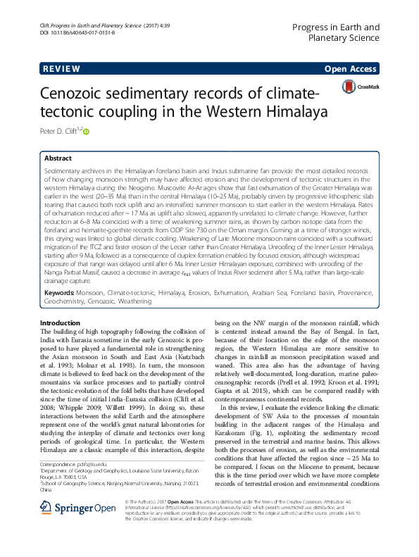
 Peter Clift