Author's personal copy
Computer Networks 54 (2010) 527–544
Contents lists available at ScienceDirect
Computer Networks
journal homepage: www.elsevier.com/locate/comnet
A survey of urban vehicular sensing platforms
Uichin Lee *, Mario Gerla
Bell Labs, Alcatel-Lucent Computer Science Department, USA
a r t i c l e
i n f o
Article history:
Available online 30 July 2009
Keywords:
Vehicular sensor networks
Survey
Comparative evaluation
a b s t r a c t
Vehicular sensing where vehicles on the road continuously gather, process, and share location-relevant sensor data (e.g., road condition, traffic flow) is emerging as a new network
paradigm for sensor information sharing in urban environments. Recently, smartphones
have also received a lot of attention for their potential as portable vehicular urban sensing
platforms, as they are equipped with a variety of environment and motion sensors (e.g.,
audio/video, accelerometer, and GPS) and multiple wireless interfaces (e.g., WiFi, Bluetooth
and 2/3G). The ability to take a smartphone on board a vehicle and to complement the sensors of the latter with advanced smartphone capabilities is of immense interest to the
industry. In this paper we survey recent vehicular sensor network developments and identify new trends. In particular we review the way sensor information is collected, stored and
harvested using inter-vehicular communications (e.g., mobility-assist mobility-assisted
dissemination and geographic storage), as well using the infrastructure (e.g., centralized
and distributed storage in the wired Internet). The comparative performance of the various
sensing schemes is important to us. Thus, we review key results by carefully examining and
explaining the evaluation methodology, in the process gaining insight into vehicular sensor
network design. Our comparative study confirms that system performance is impacted by a
variety of factors such as wireless access methods, mobility, user location, and popularity
of the information.
Ó 2010 Elsevier B.V. All rights reserved.
1. Introduction
Vehicular Ad Hoc Networks (VANETs) are acquiring
commercial relevance because of recent advances in inter-vehicular communications via the DSRC/WAVE standard, which stimulates a brand new family of visionary
services for vehicles, from entertainment applications to
tourist/advertising information, from driver safety to
opportunistic intermittent connectivity and Internet access
[1,2]. In particular, vehicular sensor networks (VSNs) are
emerging as a new tool for effectively monitoring the physical world, especially in urban areas where a high concentration of vehicles equipped with onboard sensors is
expected (see Fig. 1) [3,4]. In addition, the rising popularity
* Corresponding author.
E-mail addresses: uclee@bell-labs.com (U. Lee), gerla@cs.ucla.edu (M.
Gerla).
1389-1286/$ - see front matter Ó 2010 Elsevier B.V. All rights reserved.
doi:10.1016/j.comnet.2009.07.011
of smartphones with onboard sensors and always-on mobile Internet connections via 2/3G sheds lights on using
smartphones as a platform for participatory vehicular
sensing [5–7]. Thus, these kinds of vehicular sensing platforms will enable novel applications such as street-level
traffic flow estimation, ride quality monitoring, and proactive urban surveillance.
Vehicles are typically not affected by strict energy constraints and can be easily equipped with powerful processing units, wireless transmitters, and sensing devices even
of some complexity, cost, and weight (GPS, chemical spill
detectors, still/video cameras, vibration sensors, acoustic
detectors, etc.). VSNs represent a significantly novel and
challenging deployment scenario, considerably different
from more traditional wireless sensor network environments, thus requiring innovative solutions. In fact, differently from traditional wireless sensor nodes, vehicles
usually exhibit constrained mobility patterns due to street
�Author's personal copy
528
U. Lee, M. Gerla / Computer Networks 54 (2010) 527–544
Fig. 1. Vehicular sensor network (VSN).
layouts, junctions, and speed limitations. In addition, they
usually have no strict limits on processing power and storage capabilities.
In general, a vehicular sensor network (VSN) platform
provides a means of collecting/processing/accessing sensor
data. Vehicles continuously collect sensor data from urban
streets (e.g., images, accelerometer data, etc), which are
then processed to search for information of interest (e.g.,
recognizing license plates, or inferring traffic patterns).
The architecture of information access in a vehicular sensor network is mainly dependent on the underlying wireless access methods in vehicular environments (see
Fig. 2). If vehicles are only equipped with inter-vehicular
communications devices, it should operate in an infrastructure-free mode. The sensor data has to be processed
either locally or cooperatively, and information access is
facilitated by Vehicle-to-Vehicle (V2V) communications
[8–12]. If vehicles are also equipped with a broadband
wireless access method such as 2/3G and WiMax, sensor
data sharing can be implemented over the Internet. Mobile
users can report the sensor data (or processed sensor data)
to the Internet servers, and other users can access the
information from those servers [4,13].
In this paper, we survey recent VSN proposals and report some of the key results by carefully examining the
evaluation methodology. In Section 2, we overview various
wireless communication methods and existing routing
protocols in vehicular networks; and we also present various mobile sensing proposals in the literature. In Section 3,
we detail potential vehicular sensing applications such as
traffic monitoring, urban surveillance and road surface
monitoring. In Section 4, we review V2V-based sensor data
sharing techniques using mobility-assisted dissemination
[8–11], and geographic storage [12] and examine how
vehicular mobility (e.g., speed, density, churning, location,
etc.) influences the overall performance of the VSN platforms via simulations. In Section 5, we review infrastructure-based sensor data sharing techniques using
centralized or distributed Internet servers [4,13] and illustrate how mobile nodes interact with Internet infrastructure to support the vehicular sensor networking services.
Our survey shows that the vehicular sensor networking
system performance is mainly influenced by several factors, including: wireless access methods, vehicle mobility
(density, speed, and churning), geographic location, and
popularity of information.
2. Background and related work
We overview various wireless access methods in vehicular environments, namely DSRC/WAVE, Cellular, WiFi,
WiMAX, etc. We then outline key differences that distinguish the vehicular platform from the traditional mobile
wireless ad hoc networks (MANETs) and review various
routing protocols designed for vehicular networks. Finally,
we present various mobile sensing proposals in the literature as mobile vehicular sensing belongs to a general category of mobile sensing.
2.1. Wireless access methods in vehicular environments
2.1.1. DSRC/WAVE
Dedicated Short-Range Communication (DSRC) is a
short to medium range communication technology operating in the 5.9 GHz range [14]. The Standards Committee
E17.51 endorses a variation of the IEEE 802.11a MAC for
the DSRC link. DSRC supports vehicle speed up to
120 mph, nominal transmission rage of 300m (up to
1000 m), and default data rate of 6 Mbps (up to 27 Mbps).
This will enable operations related to the improvement of
traffic flow, highway safety, and other Intelligent Transport
System (ITS) applications in a variety of application environments called DSRC/WAVE (Wireless Access in a Vehicu-
Internet Servers
Centralized or
Distributed
Sensor Storage
Distributed Mobile Servers (Vehicles)
Cellular
/WiMAX
/WiFi
Mobility-assist data dissemination
Multi-hop routing + Geographic storage
V2I
V2V
V2V
(a) V2V-based approach
V2I
V2V
(b) Infrastructure-based approach
Fig. 2. Vehicular sensor networking scenarios.
�Author's personal copy
U. Lee, M. Gerla / Computer Networks 54 (2010) 527–544
lar Environment). DSRC has two modes of operations: (1)
Ad hoc mode characterized by distributed multi-hop networking (vehicle–vehicle), (2) Infrastructure mode characterized by a centralized mobile single hop network
(vehicle-gateway). Note that depending on the deployment
scenarios, gateways can be connected to one another or to
the Internet, and they can be equipped with computing
and storage devices, e.g., Infostations [15,16]. Readers can
find a detailed overview of the DSRC standards in [14].
2.1.2. Cellular networks
Cellular systems have been evolving rapidly to support
the ever increasing demands of mobile networking. 2G systems such as IS-95 and GSM support data communications
at the maximum rate of 9.6 kbps. To provide higher rate
data communications, GSM-based systems use GPRS
(<171 kbps) and EDGE (<384 kbps), and IS-95-based CDMA
systems use 1xRTT (<141 kbps). Now 3G systems support
much higher data rate.1 UMTS/HSDPA provides maximum
rates of 144 kbps, 384 kbps, and 2 Mbps under high mobility, low mobility, and stationary environments, respectively.
CDMA2000 1xEvDO (Rev. A) provides 3 Mbps and 1.8 Mbps
for down and up links, respectively. The average data rate
perceived by users is much lower in practice: <128 kbps
for GSM/EDGE and <512 kbps for 3G technologies. In the
US, Verizon and Sprint provide 1xEvDO, and AT&T and
T-mobile provide GSM/EDGE.
The behavior of 3G services (i.e., 1xEvDO) in a vehicular
environment was evaluated by Qureshi et al. [17].2 They reported that 1) the average RTT was consistently high
(around 600ms) with high variance ðr ¼ 350 msÞ; 2) there
were a small number of short-lived (<30 ss) disconnections
during their experiments; 3) the download throughput varied, ranging from 100 kbps to 420 kbps, and the peak upload
throughput was less than 140 kbps; and 4) they found no
correlation between the vehicle’s speed and the achieved
throughput, but geographic location is the dominant factor
leading to variations.
2.1.3. WiMAX/802.16e
802.16e or WiMAX (Worldwide Interoperability for
Microwave Access) aims at enabling the delivery of last
mile wireless broadband access (<40 Mbps) as an alternative to cable and xDSL, thus providing wireless data over
long distances. This will fill the gap between 3G and WLAN
standards, providing the data rate (tens of Mbps), mobility
(<60 km/h), and coverage (<10 km) required to deliver
Internet access to mobile clients. For its part, WiBro, developed in Korea based on 802.16e draft version 3, provides
1Km range communications at the maximum rate per user
of 6 Mbps and 1 Mbps for down and up links.3 It also supports several service levels including guaranteed QoS for delay sensitive applications, and an intermediate QoS level for
delay tolerant applications that require a minimum guaranteed data rate. Han et al. [19] measured the performance of
1
http://en.wikipedia.org/wiki/3G.
Readers can find the evaluation of UMTS/HSDPA systems in a static
environment [18].
3
The peak sector (or cell) throughput is 18 Mbps and 6 Mbps for
downlink and uplink, respectively.
529
WiBro networks in a subway whose maximum speed is
90 km/h, and showed that (1) the average uplink and downlink speeds were 2 Mbps and 5.3 Mbps respectively, and (2)
the average packet delay (half RTT) was less than 100 ms,
and almost all packets experienced delay below 200 ms, except the case when handoffs happened (>400 ms).
2.1.4. WLAN
WiFi or WLAN can also support broadband wireless services. 802.11a/g provides 54Mbps and has a nominal transmission range of 38 m (indoor) and 140 m (outdoor).
Despite its short radio range, its ubiquitous deployment
makes WLAN an attractive method to support broadband
wireless services. It has long been used as a means of Internet access in vehicles, which is known as Wardriving.4
Also, open WiFi mesh networking has received a lot of attention; e.g., Meraki sells $50 WiFi access points and provides
Internet access for free by forming a mesh network over
those access points.5 Readers can find a thorough evaluation
of WiFi performance in a vehicular environment in [20].
2.1.5. Possible vehicular networking scenarios
Given the above wireless access methods, we now summarize possible vehicular networking scenarios. If vehicles
are only equipped with DSRC, we can have an infrastructure-free mode (V2V only), infrastructure mode (V2I),
and mixed mode (V2V and V2I), as shown in Fig. 3a. Note
that this can be also done with commercial WiFi devices.
The mixed mode has been extensively studied in the research communities in terms of routing and network
capacity, and readers can find the details in [21]. If vehicles
are only equipped with other broadband wireless access
(i.e., cellular, WiMAX), we can have a scenario where vehicles can talk to each other via the Internet as in Fig. 3b. For
instance, people with iPhones or other Smart Phones with
Internet access can form a P2P overlay network via the
Internet. Finally, when vehicles have both DSRC and other
broadband wireless access methods, we can have a mixed
access scenario as in Fig. 3c. Researchers have mostly focused on the first scenario, yet the second scenario has recently received a lot of attention due to the widespread
usage of Smart Phones, or WiBro [22].
2.2. Characteristics of vehicular network environments
In designing protocols for the next generation vehicular
network, we recognize that nodes in these networks have
significantly different characteristics and demands from
those in traditional wireless ad hoc networks deployed in
infrastructureless environments (e.g. sensor field, battlefield, etc.). These differences have a significant impact on
application infrastructure.
� Vehicles have much higher power reserves than a typical mobile computer. Power can be drawn from onboard batteries, and recharged as needed from a gasoline or alternative fuel engine.
2
4
5
http://en.wikipedia.org/wiki/Wardriving.
http://meraki.com.
�Author's personal copy
530
U. Lee, M. Gerla / Computer Networks 54 (2010) 527–544
Internet
Internet
V2I-I2V
Cellular
/WiMAX
Gateway
/WiFi
V2I
V2I
V2I
V2V
(b) Cellular/WiMax
(a) DSRC/WiFi
Internet
V2I-I2V
Cellular
/WiMAX
Gateway
/WiFi
V2I
V2V
(c) DSRC/WiFi + Cellular/WiMax
Fig. 3. Possible wireless vehicular networking scenarios.
� Vehicles are orders of magnitude larger in size and
weight compared to traditional wireless clients, and
can therefore support significantly heavier computing
(and sensorial) components. This combined with plentiful power means vehicular computers can be larger,
more powerful, and equipped with extremely large storage (up to Terabytes of data), as well as powerful wireless transceivers capable of delivering wire-line data
rates.
� Vehicles travel at speeds up to one hundred miles per
hour, making sustained, consistent vehicle-to-vehicle
communication difficult to maintain. However, ‘‘existing
statistics” of vehicular motion, such as tendencies to travel together or traffic patterns during commute hours,
can help maintain connectivity across mobile vehicular
groups.
� Vehicles in a grid are always a few hops away from the
infrastructure (WiFi, cellular, satellite, etc.). Thus, network protocol and application design may depend on
easy access to the Internet during ‘‘normal” operations.
2.3. Routing in vehicular networks
Several VANET applications critically rely on VANET
routing protocols (unicast, broadcast, geocasting, etc.).
These protocols originate from prior ad hoc network architectures but have been extensively redesigned by targeting
the unique characteristics and needs of VANET scenarios
and applications. We review the VANET routing protocols
first as this offers an initial insight into VANET application
characteristics.
2.3.1. Broadcasting
Safety related applications (e.g., forward/backward
collision warnings, lane change assistance) call for the
delivery of messages to all nodes located close to the sender (reliable single/multi-hop broadcasting) with high
delivery rate and short delay. Recent research addressed
this issue by proposing reliable broadcasting strategies
[23,2]. Xu et al. [2] studied the impact of rapid repetition
of broadcast messages on the packet reception failure in
random access protocols. Torrent-Moreno et al. [23]
showed channel access time and reception probability under deterministic and statistical channel models. Yin et al.
[24] detailed the DSRC PHY layer model and incorporated
the model into a VANET simulator to support generic safety
application models. ElBatt et al. [25] modeled Cooperative
Collision Warning (CCW) applications that broadcast a
fixed size packet at a certain rate. They measured the quality of reception using Packet Inter-Reception Time (IRT)
that captures the effect of successive packet collisions on
the perceived latency. Urban Multi-hop Broadcast (UMB)
[26] supports directional broadcast in VANETs. UMB tries
to improve reliability of broadcast by alleviating a hidden
terminal problem through an RTS/CTS-style handshake,
and broadcast storms through black-burst signals to select
a forwarding node that is farthest from the sender using
location information. Unlike UMB, Broadcast Medium Window (BMW) [27] and Batch Mode Multicast MAC (BMMM)
[28] require all the receiving nodes to send back an ACK to
the sender in order to achieve reliability. BMMM has also
adapted to directional MAC in VANETs [29].
2.3.2. Unicast routing
There are many MANET routing protocols: proactive
routing (e.g., DSDV, OLSR) or reactive routing (e.g., AODV,
DSR), geographic routing (e.g., GPSR), and hybrid geographic routing (e.g., Terminode), and yet they cannot directly be used due to high mobility and non-uniform
distribution of vehicles, which causes intermittent connec-
�Author's personal copy
U. Lee, M. Gerla / Computer Networks 54 (2010) 527–544
tivity. In VANETs, geographic or hybrid geographic routing
protocols are often preferred. Also, the carry-and-forward
strategy is used to overcome intermittent connectivity;
when disruption happens, a node stores a packet in its buffer and waits until connectivity is available. Chen et al. [30]
considered a ‘‘straight highway” scenario and evaluated
two ideal strategies: pessimistic (i.e., synchronous), where
sources send packets to destinations only as soon as a multi-hop path is available, and optimistic (i.e., carry-and-forward), where intermediate nodes hold packets until a
neighbor closer to the destination is detected. In such a
highway scenario, they showed that the latter scheme
achieves a lower delivery delay. However, in more realistic
situations (i.e., Manhattan-style urban mobility and buffer
constraints), carry-and-forward protocols call for careful
design and tuning. MaxProp [31], part of the UMass DieselNet project6 has a ranking strategy to determine packet
delivery order where precedence is given in the following
order: (1) packets destined to the neighboring nodes, (2)
packets containing routing information, (3) acknowledgement packets of delivered data, (4) packets with small
hop-counts, and (6) packets with a high probability of being
delivered through the other party. VADD [32] rests on the
assumption that most node encounters happen in intersection areas. Effective decision strategies are proposed to reduce packet delivery failures and delay. Naumov and Gross
[33] proposed a hybrid geographic routing protocol, called
Connectivity-Aware Routing (CAR). Route discovery finds a
set of anchor points (i.e., junctions) to the destination via
flooding. Geographic greedy forwarding is used to deliver
packets over the anchored path.
531
documented in [37,38]. Most proposed hybrid (infrastructure and ad hoc) networks are to provide extended coverage of existing services, e.g., wireless LAN and 3G [39–41].
In addition to the extended coverage, a hybrid network can
also route packets to a remote mobile node over the infrastructure. Miller et al. [42] proposed a hybrid network
implementation where an Access Point (AP) restricts its
wireless multi-hop service to k-hops for efficiency. A mobile node joins an AP after receiving a beacon by setting
up a default path to that AP. The overall routing protocol
shares the same idea of AODV, but their protocol allows
the route discovery packet to travel over the APs. Mobile
IP for ad hoc networks can be used to support communications with hosts on the Internet. WIANI [43] extended the
previous approach and pursued load balancing among APs.
To this end, an AP periodically sends a beacon with ‘‘local”
load information; from this information, a mobile node
makes a probabilistic join decision only if it finds an AP
with load below a given threshold. A common problem of
the previous approaches is that they propose to use RREQ
flooding over APs to select and setup the rerouting path.
Unfortunately, this does not scale as the number of mobile
nodes and APs increases. To solve this problem, Gerla et al.
proposed an Overlay Location Service (OLS) [21]. OLS
maintains geographic locations of APs and mobile nodes,
and allows mobile nodes to efficiently utilize geo-routing
not only over the vehicular grid but also over the Internet.
In addition, OLS provides a ‘‘global” view of AP congestion
levels, thus leveraging efficient use of communication
resources.
2.4. Mobile sensing and sensor storage
2.3.3. Geocast
Applications for distributed data collection in a VANET
call for geographic dissemination strategies that deliver
packets to all nodes belonging to target remote areas (or
geo-casting), despite possibly interrupted paths [34–36].
MDDV [34] exploits geographic forwarding to the destination region, favoring paths where vehicle density is higher.
In MDDV, messages are carried by head vehicles, i.e., best
positioned toward the destination with respect to their
neighbors. As an alternative, Sormani et al. [35] proposed
several strategies based on virtual potential fields generated by propagation functions that encode the target areas
and the preferred paths to reach these areas. A node estimates its position in the field and retransmits packets until
nodes placed in locations with lower potential values are
found; this procedure is repeated until a packet reaches
target zones whose potential values are below a certain
threshold. Maihöfer et al. [36] proposed abiding geocast,
a time stable geocast where messages are delivered to all
nodes that are inside a destination region within a certain
period of time and discussed design space, semantics, and
strategies for abiding geocast.
2.3.4. Infrastructure-assisted hybrid routing
The benefits of using the infrastructure to enhance per
node throughput capacity of an ad hoc network are well
6
UMass’ DieselNet. http://prisms.cs.umass.edu/dome.
Traditionally, sensor networks have been deployed in
static environments, with application-specific monitoring
tasks. Recently, opportunistic mobile sensor networks have
emerged, which exploit existing devices and sensors, such
as cameras in mobile phones [44,45,12,6].
MetroSense [44] proposes a three tier architecture for
mobile sensing: servers in the wired Internet are in charge
of storing/processing sensed data; Internet-connected stationary Sensor Access Points (SAP) act as gateways between servers and mobile sensors (MS); MS move in the
field opportunistically delegating tasks to each other, and
‘‘muling” [46,47] data to SAP. MetroSense requires infrastructure support, including Internet-connected servers
and remotely deployed SAP. Similarly, Wang et al. proposed data delivery schemes in a Delay/Fault-Tolerant
Mobile Sensor Network (DFT-MSN) for human-oriented
pervasive information gathering [48]. The trade-off between data delivery ratio/delay and replication overhead
is mainly investigated in the case of buffer and energy resource constraints. Application-level protocols for the resolution of queries to sensed data have been proposed by
Riva and Borcea [45]; Contory abstracts the network as a
database and can resolve declarative queries; Spatial Programming hides remote resources, such as nodes, under local variables, thus enabling transparent access; finally,
Migratory Services are components that react to changing
context, e.g., the target moving out of range by migrating
to other nodes.
�Author's personal copy
532
U. Lee, M. Gerla / Computer Networks 54 (2010) 527–544
Regarding dissemination of sensed data through peers,
we can mention two solutions from the naturalistic environment, namely ZebraNet [49] and SWIM [16]. ZebraNet
addresses remote wildlife tracking, e.g., zebras in Mpala
Research Center in Kenya, by equipping animals with collars that embed wireless communication devices, GPS,
and biometric sensors. As GPS-equipped animals drift
within the park, their collars opportunistically exchange
sensed data, which must make its way to the base station
(the ranger’s truck). ZebraNet proposes two dissemination
protocols: a flooding-based approach where zebras exchange all the data within their buffers (either locally generated or received from other animals) with neighbors, and
a history-based protocol where data is uploaded only to
zebras with good track record of base station encounters.
SWIM [16] addresses sparse mobile sensor networks with
fixed Infostations as collecting points. Sensed data is epidemically disseminated via single-hop flooding to encountered nodes and offloaded when Infostations are in reach.
Internet-based approaches for generic sensor data sharing have a simple multi-tier structure, e.g., ArchRock [50],
SensorBase [51], and SensorMap [52], or a semi-hierarchical structure, e.g., IrisNet [53], and Global Sensor Networks
(GSN) [54]. In ArchRock [50] and SensorBase [51], sensor
data from a sensor network is aggregated at the local gateway and is published to the front-end server through
which users can share the data. In SensorBase, back-end
servers (called republishers) further process sensor data
to enable sensor data searching. SensorMap [52] is a web
portal service that provides mechanisms to archive and index data, process queries, and aggregate and present results on geocentric Web interfaces such as Microsoft
Virtual Earth. In IrisNet [53], each organization maintains
database servers for its own sensors, and a global naming
service is provided for information access. Instead of using
a global naming service, GSN [54] uses structureless P2P
communications for query resolution.
3. Vehicular sensing applications
3.1. Street-level traffic flow estimation
Most traffic information systems currently analyze data
from closed-circuit cameras and sensors installed on the
roads to estimate traffic conditions. This information is
then shared via radio broadcasts, traffic reports on the
Internet (e.g., Google Traffic), and en route traffic displays
and signals. The coverage of those systems, however, is extremely limited (e.g., mainly highways) due to high installation and maintenance costs. To overcome such
limitations, researchers have proposed to use vehicles as
sensors to collect GPS measurements using various wireless connectivity such as roadside WiFi Access Points
(APs), vehicle-to-vehicle communications, and cellular
communications (2/3G). This mobile sensor approach
greatly extends coverage, thus enabling street-level traffic
flow estimation. CarTel [4] uses roadside WiFi APs, and TrafficView [55] and MobEyes [8] use car-to-car communications. Also, cellular communications have been recently
considered: TruTraffic by Dash Express’s SatNav system
and a smartphone-based system by Nokia Research. In particular, TruTraffic collects GPS measurement data from
SatNav users using 2/3G and provides a real-time traffic
information service such as dynamic route guidance and
congestion notification.
3.2. Proactive urban surveillance
Vehicular sensing can be used for proactive urban monitoring services [8] where vehicles continuously sense
events from urban streets, maintain sensed data in their local storage, autonomously process them, e.g., recognizing
license plates, and possibly route messages to vehicles in
their vicinity to achieve a common goal, e.g., to permit
the police to track the movements of specified cars. Vehicular sensing could be an excellent complement to the
deployment of fixed cameras/sensors. This completely distributed and opportunistic cooperation among sensorequipped vehicles has the ‘‘deterrent” effect of making it
harder for potential attackers to disable surveillance.
Another less sensational but relevant example is the need
to track the movements of a car, used for a bank robbery,
in order to identify thieves, say. It is highly probable that
some vehicles have spotted the unusual behavior of
thieves’ cars in the hours before the robbery, and might
be able to identify the threat by ‘‘opportunistic” correlation
of their data with other vehicles in the neighborhood. It
would be much more difficult for the police to extract that
information from the massive number of multimedia
streams recorded by fixed cameras.
3.3. Vehicular safety warning services
Safe navigation support through wireless inter-vehicular communications has become an important priority
and new standards are emerging such as IEEE DSRC/WAVE
[14]. For instance, it can be used for forward collision
warning and advisories to other vehicles about road perils
(e.g., ice on bridge, congestion ahead). As an alternative, a
safety warning service can be supported over 2/3G. Due
to the large RTT, it is difficult to implement time-critical
real-time safety warning messaging that requires less than
several hundred millisecond responses such as notifying
braking events to vehicles behind, yet non-time critical
real-time safety warning messages could be delivered in
a timely manner over 2/3G networks.
3.4. Ride quality monitoring
Municipalities around the world spend millions of dollars to keep roads in good ride quality [56]. Ride quality
is mainly measured by the pavement roughness of a road
surface that is an expression of the surface irregularity.
The roughness causes vertical vibration of vehicles and
thus reducing ride quality. There are several main sources
of roughness: steps, dips, humps, bumps, and defects
(cracks, potholes). It also causes the stress and fatigue
damage of both vehicle and road structures. Municipalities
have been profiling roads using non-contact profiling devices mounted on the vehicles that use GPS, accelerometer/laser sensors [57]. This approach is still quite
�Author's personal copy
U. Lee, M. Gerla / Computer Networks 54 (2010) 527–544
expensive due to the operation costs and limited availability of specialized profiling devices. Researchers have recently considered using less expensive commodity
sensors; e.g., pothole detection using off-the-shelf GPS
and accelerometer sensors [58]. Also smartphones can be
treated as a good profiling platform as demonstrated in
[7]. They may have less accurate sensors, yet this can be
overcome, because a large number of people can participate in the monitoring project.
3.5. Location-aware micro-blogging
Micro-blogging is a form of multimedia blogging that allows users to send brief text updates or micromedia such as
photos or audio/video clips and publish them, either to be
viewed by anyone or by a restricted group which can be chosen by the user (e.g., Twitter) [59]. The content of a microblog differs from a traditional blog in that it is typically more
topical, smaller in aggregate file size (e.g. text, audio or video). Gaonkar et al. [60] recently proposed location-aware
micro-blogging where micro-blogs are superimposed on
physical space based on device’s location awareness (e.g.,
GPS). For instance, an individual’s micro-blogs about a restaurant may float near the restaurant. Mobile users can sift
through micro-blogs to find information of interest. Microblogging would be extremely useful in vehicular environments, providing means of sharing useful information while
mobile users are behind the wheel; e.g., pictures of accidents, construction, or malfunctioning traffic signals, etc.
4. V2V-based VSN platforms
We review V2V-based VSN platforms, namely MobEyes
[8–10], FleaNet [11], and VITP [12]. Both MobEyes and
FleaNet use mobility-assisted data dissemination to facilitate information access. VITP uses the concept of geographic storage; i.e., the sensor information is stored in
an area where it is generated, and mobile users pull it by
sending a request to the area of interest.
4.1. MobEyes: proactive urban monitoring services
MobEyes aims at provisioning proactive urban monitoring services where vehicles continuously monitor events
from urban streets, maintain sensed data in their local
storage, process them (e.g. recognizing license plate numbers), and route messages to vehicles in their vicinity to
achieve a common goal (e.g., to allow the police to find
the trajectories of specific cars) [8–10]. However, this requires the collection, storage, and retrieval of massive
amounts of sensed data. In conventional sensor networks,
sensed data is dispatched to ‘‘sinks” and is processed for
further use (e.g., Directed Diffusion [61]), but that is not
practical in VSNs due to the sheer size of generated data.
Moreover, it is impossible to filter data a priori because it
is usually unknown which data will be of use for future
investigations. Thus, the challenge is to find a completely
decentralized VSN solution, with low interference to other
services, good scalability, and tolerance to disruption
caused by mobility and attacks.
533
4.1.1. MobEyes protocols
In MobEyes, each sensor node performs event sensing,
processing/classification of sensed data, and periodically
generates meta-data of extracted features and context
information such as timestamps and positioning coordinates. Meta-data are then disseminated to other regular
vehicles, so that mobile agents, e.g., police patrol cars,
move and opportunistically harvest meta-data from neighbor vehicles. As a result, agents can create a low-cost
opportunistic index which enables agents to query the
completely distributed sensed data storage. This enables
us to answer questions such as: (1) which vehicles were
in a given place at a given time?; (2) which route did a certain vehicle take in a given time interval?; and (3) which
vehicles collected and stored the data of interest?
4.1.1.1. Meta-data diffusion. Any regular node periodically
advertises a packet with a set of newly generated metadata to its current neighbors. Each packet is uniquely identified (generator ID + locally unique sequence number).
This advertisement to neighbors provides more opportunities for mobile agents to harvest the meta-data packets.
Note that the duration of periodic advertisement is configured to fulfill the desired latency requirements, because
harvesting latency depends on it. Neighbors receiving a
packet store it in their local meta-data databases. Therefore, depending on node mobility and encounters, packets
are opportunistically diffused into the network. MobEyes is
usually configured to perform ‘‘passive” diffusion: only the
packet source advertises its packets. Two different types of
passive diffusion are implemented in MobEyes: single-hop
passive diffusion (packet advertisements only to singlehop neighbors) and k-hop passive diffusion (advertisements travel up to k-hops as they are forwarded by j-hop
neighbors with j < k). MobEyes can also adopt other diffusion strategies, for instance single-hop ‘‘active” diffusion,
where any node periodically advertises all packets (generated and received) in its local database at the expense of a
higher traffic overhead. In a usual urban VANET, it is sufficient for MobEyes to exploit the lightweight k-hop passive
diffusion strategy, with very small k values, to achieve the
needed diffusion.
Fig. 4 depicts the case of a VSN node C1 encountering
other VSN nodes while moving (for the sake of readability,
only C2 is explicitly represented). Encounters occur when
two nodes exchange meta-data, i.e., when they are within
their radio ranges and have a new meta-data packet to
advertise. In the figure dotted circles and timestamped triangles represent respectively radio ranges and C1 encounters. In particular, the figure shows that C1 (while
advertising SC1;1 ) encounters C2 (advertising SC2;1 ) at time
T � t4 . As a result, after T � t 4 C1 includes SC2;1 in its storage, and C2 includes SC1;1 .
4.1.1.2. Meta-data harvesting. In parallel with diffusion,
meta-data harvesting can take place. A mobile agent, e.g.,
a police patrol car, can request the collection of diffused
meta-data packets by proactively querying its neighbor
nodes. The ultimate goal is to collect all the meta-data
packets generated in a given area. Obviously, a mobile
agent is interested in harvesting meta-data packets it has
�Author's personal copy
534
U. Lee, M. Gerla / Computer Networks 54 (2010) 527–544
Advertise Sc2,1
C2
T
Advertise Sc1,1
Local DB
Time Sum.
0
SC2,1
T-t4 SC1,1
C1
T
Local DB
Time Sum.
0
SC1,1
T-t4 SC2,1
T-t1
T-t5
T-t6
T-t2
T-t4
T-t3
Encounter Point
Trajectory
Fig. 4. MobEyes single-hop passive diffusion.
Fig. 5. Map of Westwood area in vicinity of UCLA campus.
not collected so far. To focus only on missing packets, a
mobile agent compares its already collected packets with
the packet list at each neighbor (a set difference problem),
by exploiting a space-efficient data structure for membership checking, i.e., a Bloom filter. A Bloom filter for representing a set of n elements consists of m bits, initially set
to 0. The filter applies k independent random hash functions h1 ; . . . ; hk to packet identifiers and records the presence of each element into the m bits by setting k
corresponding bits. To check the membership of the element x, it is sufficient to verify whether all hi ðxÞ are set.
Thus, the harvesting procedure consists of the following
steps. First, the police agent broadcasts a ‘‘harvest” request
with its Bloom filter. Second, each neighbor prepares a list
of ‘‘missing” packets from the received Bloom filter. Third,
one of the neighbors returns missing packets to the agent.
Fourth, the agent sends back an acknowledgment with a
piggybacked list of just received packets. Upon listening
or overhearing this, neighbors update their missing packet
lists for the agent. Steps 3 and 4 are repeated until there
are no missing packets.
ing communication model: MAC protocol IEEE 802.11,
transmission band 2.4 GHz, bandwidth 11 Mbps, nominal
radio range equal to 250 m, and Two-ray Ground propagation model.
Frac. of passively harvested summaries
4.1.2. Performance analysis
We evaluate MobEyes protocols via extensive ns-2 [62]
simulations [8–10]. This section summarizes the most
important results, with the goal of investigating MobEyes
performance from the following perspectives: meta-data
diffusion/harvesting speed in urban environments, and
vehicle tracking application. In the simulations, we consider vehicles moving in a fixed region of size
2400 m � 2400 m. The default mobility model is Real-Track
(RT) that models realistic vehicle motion in urban environments [63]. In RT, nodes move along virtual tracks, representing real accessible streets on an arbitrary loaded
roadmap. For this set of experiments, we used a map of
the Westwood area in the vicinity of the UCLA campus,
as obtained by the US Census Bureau data for street-level
maps [64] (Fig. 5). At any intersection, each vehicle randomly selects the next track it will run through; speed is
periodically changed (increase or decrease) by a quantity
uniformly distributed in the interval ½0; �Ds�. Our simulations consider number of nodes N ¼ 100; 200; 300, moving
with average speed of v ¼ 5; 15; 25 m=s. The meta-data
advertisement period of regular nodes and the harvesting
request period are kept constant as 3 s. We use the follow-
4.1.2.1. Diffusion and harvesting performance. We investigate the regular node collection (diffusion) and mobile
agent harvesting processes. We evaluate the cases with
the number of nodes N ¼ 100=300, and the average speed
v ¼ 5=25. Fig. 6 plots the cumulative distribution of metadata collected by regular nodes as a function of time. The
process highly depends on the average node speed; in fact,
the speed determines to a large extent how quickly nodes
‘‘infect” other participants with their own meta-data. The
results do not depend on node density. Fig. 7 plots the
cumulative distribution of meta-data harvested by a police
agent as a function of time. The results are mainly dependent on the speed, but unlike passive harvesting, the density plays an important role in active harvesting.
Intuitively, if there are more neighbors, the agent has a
higher chance of collecting an arbitrary meta-datum. In
Fig. 8, we also plot the cumulative distribution of metadata harvested by 1; 3 agents ða#Þ with k ¼ 1; 3 relay hops.
This estimation is useful to decide the tuning of the parameters (k-hop relay scope and number of agents) to address
application requirements. Fig. 8 shows how the number of
agents, the choice of the number of relaying hops k, and the
average speed v of the nodes influence the process. In the
1
0.9
0.8
0.7
0.6
0.5
0.4
0.3
RT N=300 v=25
RT N=100 v=25
RT N=300 v=5
RT N=100 v=5
0.2
0.1
0
0
1000
2000
3000
4000
Time (seconds)
Fig. 6. Meta-data diffusion.
5000
�Author's personal copy
535
Frac. of actively harvested summaries
U. Lee, M. Gerla / Computer Networks 54 (2010) 527–544
1
0.9
0.8
0.7
0.6
0.5
0.4
0.3
N=300/v=25 Sim
N=100/v=25 Sim
N=300/v=5 Sim
N=100/v=5 Sim
0.2
0.1
0
0
200
400
600
800
1000 1200 1400
find matches of interest. Vehicles as well as static roadside
Advertisement Stations (or Adstations) generate and propagate queries which can be either user generated content
using on-board sensors (e.g., images, video clips, etc.) or
commercial advertisements (e.g., special offers). Thus, a
vehicle can be both a publisher and a subscriber of information. For example, a mobile user who takes pictures of
an accident (publisher) can propagate the information to
other vehicles nearby (subscriber); and a pizzeria (publisher) could advertise its special pizza offer to vehicles
passing by and a driver (subscriber) who received the
advertisement could place an order.
Time (seconds)
Fig. 7. Meta-data harvesting.
case of multiple agents, the harvesting process considers
the union of the summary sets harvested by agents. The
figure clearly shows that k-hop relay scope and multiple
agents highly impact harvesting latency.
4.1.2.2. Tracking application. In the vehicle tracking application, an agent reconstructs a trajectory of an arbitrary
node by exploiting the collected meta-data. To show this,
we configure the regular node to generate new meta-data
every T ¼ 120 s and to continuously advertise the latest
meta-data. Every meta-data includes the license plate
number and position of the vehicle nearest to the metadata originator at the generated time, tagged with a timestamp. The tracking application exploits the MobEyes
diffusion protocol with k ¼ 1 to spread the meta-data
and deliver as much information as possible to a single
agent scouting the ground. As the agent receives the
meta-data, it extracts the information about node plates
and positions, and tries to reconstruct node trajectories
within the area. Its effectiveness is illustrated in Fig. 9 that
visualizes the reconstructed trajectory.
4.2. Virtual information exchange bazaar
FleaNet [11] operates on the vehicular networks and
provides an excellent method for people to communicate
with each other as information traders and to efficiently
4.2.1. FleaNet query dissemination protocol
FleaNet utilizes mobility assisted query dissemination
where the query ‘‘originator” periodically advertises its
query only to 1-hop neighbors. Each neighbor then stores
the query in its local database without any further relaying; thus, the query spreads only because of vehicle motion. Upon receiving a query, a node tries to resolve it
locally in its database; in case of success, the originator will
be automatically informed. A match only happens in its
neighbors and thus, there is no redundant notification.
Since this match could lead to a further interaction (e.g.,
downloading a file stored in the remote node), FleaNet provides a mechanism to deliver data using multi-hop intervehicular communications. A user could see multiple
matches for a given query. Based on a user’s own criterion
(either on distance from the current location), a mobile
user selects the best one and sends a request message.
Then, the target user responds with the reply after seeing
the request. To support this, FleaNet uses Last Encounter
Routing (LER) [65]. LER is based on geo-routing and combines location and routing services. In FleaNet the query
packet includes the originator geo-coordinates, and thus,
LER does not incur any initial flood search routing cost.
4.2.2. Performance analysis
We evaluate FleaNet performance through extensive
simulations using ns-2 [11]. Each node is considered to have
802.11a connectivity with a bandwidth of 11 Mbps, 250 m
radio range, and two-ray ground reflection model for radio
propagation. For realistic mobility generation, we use
VanetMobiSim that simulates macro- and micro-mobility
2500
Actual path
Sampled points
2000
0.8
Y-coord
Fraction of harvested summaries
1
0.6
1500
1000
0.4
#a=3/k=3
#a=3/k=1
#a=1/k=3
#a=1/k=1
0.2
500
0
0
0
0
100
200
300
400
500
600
700
800
500
1000
1500
2000
2500
X-coord
Time (seconds)
Fig. 8. Meta-data harvesting with multi-agents.
Fig. 9. Actual node trajectory (the unbroken line) vs. reconstructed
sampled points.
�Author's personal copy
536
U. Lee, M. Gerla / Computer Networks 54 (2010) 527–544
4.2.2.1. Impact of density/speed. Fig. 10 shows the latency
as a function of density and speed in each node density
with a single publisher. For each node density, a node is
randomly selected as a subscriber to evaluate how node
density affects the matching latency depending only on
the speed. From the figure, we see that both the density
and speed of vehicles are important factors in determining
the latency. As the average speed or the number of nodes
increases, the matching latency decreases. This is not surprising since as the average speed or the number of nodes
increases, a node has a higher chance of meeting other
nodes, which translates into more rapid dissemination of
the query and also a higher chance to find a match.
Matching latency (seconds)
450
N = 100
N = 200
N = 300
N = 400
400
350
300
250
200
150
100
50
50
40
30
20
10
0.05
5
10
15
20
Average speed (m/s)
Fig. 10. Impact of density/speed.
25
0.1
0.15
0.2
0.25
popularity
Fig. 11. Impact of query popularity.
of 5% on the X-axis and vary the number of nodes (i.e.,
100–400 nodes). Given a single subscriber, x% publishers
are randomly selected and we measure the latency for
notification. We limit ourselves to the single subscriber
case to clearly see the impact of query popularity on the latency. The figure clearly confirms our intuition about the
impact of popularity on the latency: as the popularity increases, the latency decreases.
4.2.2.3. Impact of location. Nodes can be static, e.g., Adstation, in FleaNet. In this section, we show how a stationary
node affects the average notification latency, i.e., the impact
of its location. Intuitively, since the average relative speed
of two nodes is higher if both move, a mobile node has a
higher chance of meeting more nodes than a stationary node, which results in faster query dissemination.
Restricted mobility in the Westwood mobility model makes
the situation of a stationary node worse, because nodes
tend to stay longer in the area where roads are densely clustered together. To understand how the position of a stationary node affects the latency, we use a scenario with 100
nodes moving at the average speed of 25 m/s. The 100
nodes are randomly selected in the map. Given the set of
nodes, we generate 100 scenarios by adding a stationary
node as a subscriber at the initial coordinate of each node.
Thus, for a given subscriber (i.e., a scenario file) we perform
100 trials to get the average latency, by selecting each one
of the other 100 nodes as a publisher. Queries are broadcast
within three-hop neighbors, and no additional query adver800
700
600
500
400
300
200
100
0
0
100
200
300
400
60
0
Average total latency (seconds)
4.2.2.2. Impact of query popularity. The overall latency is
heavily dependent on the query popularity. We can easily
see that if many people are interested in specific information, notification will quickly happen. To show this, we plot
the latency as a function of popularity in a single-subscriber, k-publisher case in Fig. 11. We increase the ratio
of publishers in the network from 5% to 25% with a gap
70
Average total latency (Seconds)
patterns in urban environments [66]. Macro-mobility deals
with road topology/structure and traffic signs (stop signs,
traffic lights, speed limits), and micro-mobility models the
speed and acceleration of each vehicle. We use the Westwood topology from Tigermap (TGR06037, Los Angeles)
that represents the area in the vicinity of the UCLA campus
(see Fig. 5). The simulations consider a vehicular network
with the number of nodes between 100 and 400 in a
2400 m � 2400 m area. Vehicles travel with an average
speed between 5 m/s and 25 m/s. To evaluate the performance, we mainly use the average latency of notification
completion. For a given query, the matching latency measures the time for a node to receive a match, which happens
when it encounters a node that carries a matching query.
Then, a data request packet is sent to the query originator
by using the Last Encounter Routing (e.g., from a publisher
to subscriber, or vice versa) and the routing latency measures the time to deliver the notification to the destination.
In our simulations, we assume that a user immediately
sends a request to the other party. Thus, the total latency
is the sum of matching and routing latency. The latency is
dependent on many parameters, specifically on density/
speed, query popularity, and mobility.
1
11
21
31
41
51
61
71
Rank
Fig. 12. Impact of location.
81
91
�Author's personal copy
U. Lee, M. Gerla / Computer Networks 54 (2010) 527–544
tiser is applied on the scenario. In Fig. 12, the total latency
distribution is presented in ascending order with the rank
of the delay on the X-axis. The ith index of the X-axis represents a node with ith largest latency. For example, the
smallest latency (rank 1) is 55.4 s, while the largest latency
(rank 100) is 755.9 s. As we can see, the largest latency is
13.6 times higher than the smallest one, and thus, the latency heavily depends on the location. By examining the
location of the static node in each experiment we found
that the first 10% stationary nodes (Rank 1 to 10) are located
on the south west side of the map where the entrance to the
highway is located. In fact, there is high traffic around the
high entrance and the loop to the highway in the scenario.
Therefore, it is likely that the stationary node in the area has
the highest probability of encounter with other nodes. On
the other hand, the last 10% stationary nodes (Ranks 91–
100) are placed either at the border of the map or in the
northwest area where roads are sparse.
4.2.2.4. Impact of churning. We measure the latency of stationary nodes in presence of churning where nodes move
out of the network area (or out of the region of interest).
When a node reaches the border area of the network
(100 m width), we reset a node’s buffer with probability
p. The higher the probability, the higher is the churning
rate. We vary the reset probability p from 0 to 0.6 with a
gap of 0.2 to show the impact of churning. Fig. 13 shows
the delay distribution using a box-and-whisker plot. As
shown in the graph, the median value increases as the reset probability increases. The median increases from
165.34 s to 319.79 s as the reset probability increases to
0.6. Similarly, the maximum delay with 0.6 reset probability is about 196 s larger than that without churning. By
manually examining the results, we find that some stationary nodes located at the border area have a noticeable delay increment of 22.6%. In our earlier section, we show that
stationary nodes with high delay are placed either at the
border of the map or in the northwest area where roads
are sparse. Nodes visit these sites less frequently than the
other sites due to the road layout. Moreover, those nodes
traveling near the border area are more likely to suffer
from churning. Thus, stationary nodes near the border area
have much higher delay as churning increases.
Average total latency (seconds)
1000
Quartiles
800
537
4.3. Other related works
There are several other related works, namely geographic
storage, and content distribution. In geographic storage, publishers store information in a geographic region from which
mobile users can pull information on-demand. Efficient content distribution is necessary when the size of sensor data is
too large and it has to be distributed to a number of users.
4.3.1. Geographic storage
Vehicular Information Transport Protocol (VITP) [12]
uses the concept of geographic storage to support various
on-demand location aware services such as traffic conditions (e.g., congestion, traffic flows), traffic alerts (e.g., accidents), and roadside service directories (e.g., location/menu
of a local restaurant). In geographic storage, the information can be retrieved in a geographic area where it is generated, which is different from a Geographic Hash Table
(GHT) where a data item is hashed and is stored in an arbitrary position [67]. VITP is an application-layer, stateless
communication protocol that specifies the syntax and
semantics of messages carrying location-sensitive queries
and replies between the nodes of a VANET. One of the key
features of VITP is that it allows nodes to aggregate (or summarize) location sensitive information and to report the
summarized results to the requester. Fig. 14 shows the
illustration of VITP operations. Node V wants to know the
average vehicle speed near the gas station, and it sends
the query Q to the destination location (i.e., dispatch phase).
VITP-enabled peers around that destination location cooperatively resolve the query (i.e., computation phase) and return a reply R to the requester (i.e., reply-delivery phase).
4.3.2. V2V content distribution
For efficient content distribution, Nandan et al. [1] proposed SPAWN, a BitTorrent-like file swarming protocol in a
VANET. In SPAWN, a file is divided into pieces and is uploaded into a road side stationary server or a mobile node.
Each file has a unique ID (e.g., hash value of the file content), and each piece has a unique sequence number.
Nodes cooperatively exchange missing pieces. By extending SPAWN, Lee et al. [68] proposed CarTorrent. Given that
proximity is the key factor of peer selection, CarTorrent
uses k-hop limited probabilistic gossiping and ClosestRarest First for piece/peer selection. CarTorrent uses a
cross-layer approach in that route discovery of underlying
on-demand protocols is utilized for gossiping. Lee et al.
[69] proposed CodeTorrent, a network coding based content distribution protocol based on the fact that network
coding can mitigate the rare piece problem [70,71].
600
5. Infrastructure-based VSN platforms
400
In this section, we review Internet-based VSN platforms, namely Senster [13] and CarTel [4].
200
0
0
0.2
0.4
Reset probabilty
Fig. 13. Impact of churning.
0.6
5.1. Senster: A mobile platform for scalable vehicular sensing
It is a promising option to realize vehicular sensing
using smartphones now on the market, such as the iPhone
�Author's personal copy
538
U. Lee, M. Gerla / Computer Networks 54 (2010) 527–544
Node V
Gas Station
Q: Avg. vehicle speed
nearby the gas station
Q
VS2
VAHS
VS3
VS1
Q
Q
Q
Q
R
Q2
VS4
Q1
R
VS5
R: 30m/h
Fig. 14. An Illustration of VITP.
and Nokia N95. These phones are equipped with onboard
sensors (e.g., voice, image, video, accelerometer, GPS) and
have ‘‘always-on” mobile Internet connections via 2.5/3G.
External sensors wirelessly interface to phones via Bluetooth or WiFi. Given the fact that there were 64 million
3G devices in the US in June 2008 [72], millions of users
could simultaneously use the system. Thus, there is a need
for large scale ‘‘distributed” storage that facilitates information sharing among millions of mobile users via always-on 2/3G connections.
A promising design option is to use a mobile-to-mobile
overlay network of 2/3G users [22]. However, P2P connections between mobile devices are not always possible due
to Network Address Translation (NAT). NATing is a commonly used technique in the mobile operator’s domain
due to lack of IP addresses [73]. Although there are several
known techniques to overcome NATing [74], they are generally not applicable to mobile clients due to complex
packet processing in the mobile operator’s domain [73].
For P2P, we need additional services such as Session Initiation Protocol (SIP) or P2P proxies [73,75]. Another potential problem is that 2/3G cellular networks suffer from very
large round trip delay (around several hundred milliseconds [17]); protocol operations in a large-scale P2P overlay
may cause an intolerable delay in highly mobile vehicular
environments.
In [13], we proposed a two-tier sensor storage Senster
that exploits the Internet infrastructure. We assume that
users install Senster clients in both PCs/laptops and smart
phones. Internet clients on PCs/laptops provide a distributed P2P sensor storage over the Internet, through which
mobile clients can publish/access sensor data (See
Fig. 15). Senster considers the following design goals:
localized publish/lookup to minimize the communication
overhead; dynamic load balancing to handle heterogeneous vehicular density; complex query support such as
range queries, and; data access among mobile users.
5.1.1. Senster protocols
5.1.1.1. SenterKBR: Key Based Routing. Senster uses Mercury DHT [76] for Key Based Routing. Mercury DHT relies
on Symphony DHT [77] that guarantees logarithmic properties of DHT operations by maintaining k random long
links, inspired by the small world phenomenon. Recall that
CAN [78] requires us to increase the dimension of key
space to Hðlog nÞ in order to guarantee logarithmic properties. However, this is inappropriate to our 2D vehicular
pffiffiffi
sensing scenario because the lookup/update cost is Oð nÞ.7
As shown in Fig. 16, we consider the 2D urban area for
vehicular sensing. In Senster, we predefine the size of a
grid and discretize the 2D space, by linearizing the space
using a Hilbert space filling curve (i.e., each grid point is
numbered). We assume that Senster-enabled nodes have
the Hilbert space mapping a priori. For any geographic
location, a node can find the associated geographic grid
ID (or geo-ID) on the Hilbert curve. Unlike traditional DHTs
where ‘‘consistent hashing” is used to map both node ID
and keywords to a key space (e.g., CAN, Chord), Senster
uses a geographic ID in the Hilbert curve as a key space
[79,76]. Every sensor data generated is tagged with the
geo-ID, and is stored on the Internet server that handles
the corresponding geographic ID. This enables us to efficiently support range queries without maintaining other
data structures as in [80].
Unicast routing (or geographic unicast routing) is quite
straight-forward using Mercury DHT. Since SensterDB may
receive a geographic region query (e.g., average speed in a
certain region), SensterKBR provides geographic multicast
as well. Given the region information, each node can translate the shape and can find a set of ordered linear segments
in the Hilbert curve space. Geographic multicast can be
efficiently supported by hopping through the linear segments. The search costs vary depending on the size of covered space. When the covered space is lower than
7
Not that Content Addressable Network (CAN) [78] dynamically divides
d-dimensional Cartesian coordinate space among all the nodes in the
system such that every node possesses at least one distinct zone within the
1=d
overall space. CAN routes a packet in Oðdn Þ hops; logarithmic hop can
only be achieved when d ¼ log2 n=2. When we directly map 2D space
pffiffiffi
ðd ¼ 2Þ, the routing cost becomes Oð nÞ, failing to guarantee logarithmic
routing.
�Author's personal copy
539
U. Lee, M. Gerla / Computer Networks 54 (2010) 527–544
Internet Clients
- Internet-based P2Psensor
data storage + routing
- Applications (traffic, road
quality, micro-blogging)
(2,1)
(1,1)
Cellular: 2/3G
Mobile Clients
- Sensor data acquition, on-board
processing, and publishing
- Application access
Grid Loc: (1,1)
Grid Loc: (2,1)
Fig. 15. Senster, a two-tier sensor storage framework.
16
1
2
15
14
13
12
11
3
1Dkeyspace
4
5
mobilenode
association
6
1
9
8
7
2
4
10
15
3
16
14
13
2Dspace
5
6
8
7
9
10
an UPDATE upcall to notify the change to all the applications,
including SensterDB. As in KBR [83], SensterKBR exports
the routing status information (e.g., current key range,
neighbor set) to the upper layer via several access
functions.
12
11
Fig. 16. Hilbert space filling example.
1=Hðlog nÞ fraction of the key space, we can prove that the
multicast cost is bounded by Oðlog nÞ.
5.1.1.2. SensterDB:
distributed
database
over
SensterKBR. SensterDB manages the sensor data indexed
by a certain key range to allow expressiveness and optimization using underlying SenterKBR. SenterDB supports a
relational database model and a declarative query language (SQL). The current SensterDB prototype uses
HSQLDB as a lightweight database [81]. The database can
be extended to support stream data processing (e.g., periodic traffic information reporting). The key difference from
conventional DBMS is that due to Internet scale database
processing, we relax ACID requirements and perform
best-effort (or approximate) query processing as in [82].
The data access patterns can be categorized as either spatial or temporal filtering. Spatial filtering occurs as spatial
range queries are frequent, for example, finding traffic patterns along the commuting path. Temporal filtering occurs
in cases where time is used for filtering values from a given
area. These queries can also be one-shot or continuous.
Simple approximate continuous query functionality can
be provided by issuing a one-shot query at regular time
intervals. SensterDB interacts with SensterKBR for key
space management. Whenever there is a change in the
key space (due to node join/leave), SensterKBR invokes
5.1.1.3. SensterMobile: mobile client. SensterMobile provides a common software architecture to interact with
SensterKBR and to enable sensor data acquisition from different mobile platforms. In Fig. 17, we present the design
of the SensterMobile architecture that allows efficient control of and transparent access to sensing resources. For
each service, we define a set of filter applications running
on the mobile client. For instance, traffic information services may require installing filters for reporting the average speed per road segment, and the braking pattern
information (by processing the accelerometer data). After
processing, the filters publish the summary data via the
SensterKBR mobile client that provides transparent data
delivery using standard send/receive interfaces. These
filters acquire sensor data using a SQL-like sensor access
Internet Overlay
SensterKBR Mobile Agent
Request
Handler
App
Filter 1
App
Filter N
Sensor Access Common Interface
Sensor Resource Manager
GPS
Accelerometer
Micro
Phone
Camera
Mobile Node
Fig. 17. SensterMobile software framework.
�Author's personal copy
U. Lee, M. Gerla / Computer Networks 54 (2010) 527–544
query language similar to the one defined in [4]. For instance, a filter requires access to sensor 1 and sensor 2 under specific conditions of sensor1 data value less than 10
and sensor 2 value greater than 30 for every 5 s; e.g., select
* from sensor1, sensor2 where sensor1 < 10 and sensor2 > 30
interval 5 s. SQL provides predicates that allow detailed
sensor configuration depending on the sensor type. The
sensor resource manager takes these SQL sensor access
queries and configures the sensors. Raw sensor data are
then stored in its local storage, and query results are reported to the filters according to their requested rates.
External nodes can also access the raw data from SensterDB. A remote request is delivered to the remote request
manager. It then sends the request to the resource manger
and returns the results via the SensterKBR mobile client.
5.1.2. Performance analysis
We evaluate the performance of content-based routing
using extensive simulations. In particular, we evaluate the
following: (1) the importance of load balancing in a very
large-scale network scenario, (2) the locality of contentbased routing, (3) the impact of different region sizes on
the routing cost, and (4) the impact of mobility patterns
and grid sizes on hand-off overhead. We implement an
event-driven discrete-time simulator where each application level hop takes a unit time. For the sake of a large network simulation, our simulator does not model any
queueing delay at intermediate nodes or packet loss on
links. The simulator is implemented in C# (.NET framework 3.5) and provides a GUI for dynamic node generation/join/leave, load balancing, and multicasting features.
The number of long links in the Mercury DHT is set to
five, as recommended in Symphony DHT [77]. We discretize the network area into grids for the Hilbert curve-based
linearization: from 64 � 64 to 256 � 256. For realistic
mobility generation, we use VanetMobiSim that simulates
macro- and micro-mobility patterns in urban environments [66]. The network area size ranges from
3200 m � 3200 m and 12,800 m � 12,800 m. The Westwood topology from Tigermap (TGR06037, Los Angeles)
represents the area in the vicinity of the UCLA campus.
We use the random trip generation module in VanetMobiSim: each vehicle randomly picks starting and ending
points in the map and moves along the shortest path, yet
considering traffic congestion.
5.1.2.1. Load balancing. Mobile nodes publish sensor data
to the overlay nodes. We study how heterogeneous distribution of vehicles influences the overall load imbalance.
We use the Los Angeles map to extract road topology information. The area size is 12; 800 m � 12; 800 m, centered at
the UCLA campus. The northern parts of the area are residential (low road density), whereas the southern parts
are commercial districts (high road density). We use the
grid size of 50 m � 50 m. The area is composed of
256 � 256 grids. We simulate different numbers of mobile
clients from 1000 to 5000 with a gap of 1000 nodes. The
number of overlay nodes is fixed to 1000 nodes. We measure the total published data size per node and draw a boxplot in Fig. 18. The results show that the total data size
increases linearly, as the number of mobile clients in-
creases. Also, the case without load balancing shows much
higher variation as opposed to the case with load balancing. There are still minor variations in the case with load
balancing. This is because the system load of SensterKBR
becomes balanced after several iterations of leave/joinbased load balancing operations. We then vary the number
of overlay nodes from 1000 to 5000 nodes. The number of
mobile clients is fixed to 10,000 nodes.
5.1.2.2. Locality of content-based routing. Content-based
routing in Senster exploits the geographic locality, on top
of logarithmic routing performance. The construction of
the Hilbert curve shows that packet forwarding happens
within the area of interest (usually, a small fraction of the
entire key space). To clearly show this, we place a node at
a grid point (0,0) and measure the cost of a remote query
with the square area of size 3 � 3, by changing its location
from (0, 0) to (253, 253). The number of overlay nodes is
set to 1000. In Fig. 19, we plot routing hop counts over
the 256 � 256 grids. The figure shows that as distance from
(0, 0) increases, the hop counts also increases. The reason
why it shows non-contiguous colors is that we lose 50% of
locality, yet locality is preserved at the higher level thanks
to the recursive construction property of the Hilbert curve.
5.1.2.3. Impact of different region sizes. We show the sensitivity of routing cost with different geocasting area sizes:
2 � 2; 3 � 3; 4 � 4, and 8 � 8. We vary the number of overlay nodes from 1000 to 5000 with a gap of 1000 nodes. In
Fig. 20, we plot the average number of hop counts as a
function of the number of overlay nodes. The average value
comes from the previous simulation setting, by averaging
the hop counts of all scenarios; i.e., by covering all the
query regions from (0, 0) to (255-M, 255-M) where M is
the side length of a region. The figure shows that as the
number of overlay nodes increases, the average hop count
also increases (logarithmically). The query size does not
change the overall cost significantly. For small area queries
(e.g., 2 � 2 and 3 � 3), it is likely that a single node covers
the queried area, whereas for a slightly large query 8 � 8, a
few overlay nodes may be required, thereby increasing hop
counts.
5.1.2.4. Hand-off overhead analysis. For hand-off analysis,
we consider dense scenarios: a network area of size
35
Payload [MBytes]
540
30
25
20
15
10
5
0
[Number of mobile clients]
Fig. 18. Total published data size per overlay node.
�Author's personal copy
U. Lee, M. Gerla / Computer Networks 54 (2010) 527–544
Fig. 19. Locality of content-based routing: routing cost from (0, 0) to
ðX; YÞ.
14
2x2query
4x4query
3x3query
8x8query
541
before delivering them to a central portal, where the data
is stored in a database for further analysis and visualization. CarTel provides a simple query-oriented programming interface that can handle large amounts of
heterogeneous data from sensors. CarTel nodes rely primarily on opportunistic wireless (e.g., Wi-Fi hotspots) connectivity to the Internet. For delay tolerant data delivery,
mobile nodes receive the data packets, hold them in storage, and wait for opportunities to transfer the data to remote destinations (called CafNet protocol). CarTel
applications run on an Internet portal that uses a delay tolerant continuous query processor, called ICEDB, to specify
how the mobile nodes should summarize, filter, and
dynamically prioritize data. Fig. 22 shows the overall system architecture. Several applications were proposed such
as road traffic analysis (e.g., commute time calculation),
wide-area WiFi measurement, and automotive diagnostic
using OBD-II output.
Mean Hop Count
12
10
8
6
4
2
0
1000
2000
3000
4000
5000
Numberofoverlay nodes
Fig. 20. Average hop counts with different region sizes.
3200 m � 3200 m with 1000, 2000, 3000 mobile clients.
We set the maximum node speed to 10 m/s. We use grid
sizes of 256 � 256 and the number of overlay nodes is fixed
to 1000. Fig. 21 shows the average number of hop counts
with different mobility patterns. As expected, the hop
count increases as the number of mobile clients increases.
The figure also shows the handoff cost is independent of
the grid size, but depends on the number of overlay nodes.
The handoff cost is mainly determined by the average key
space per node.
5.2.1. Intermittently connected DB (ICEDB)
ICEDB has a server component (Internet portal side) and
a client component (mobile side). ICEDB server maintains a
list of continuous queries submitted by applications where
queries are pushed to mobile nodes using CafNets, a delay
tolerant data delivery protocol. ICEDB client processes
sensed data and returns the query results using CafNet. Results from ICEDB clients are stored in RDBMS of the portal.
ICEDB uses an adaptor that defines a sensor type and schema. For example, CarTel has adapters for GPS, OBD-II,
Wi-Fi, and cameras. The key innovation of ICEDB is that
since delivering data in FIFO order is suboptimal in bandwidth-constrained vehicular networks, ICEDB implements
prioritization. To be precise, local prioritization determines
the priority within a given query buffer. For global prioritization, ICEDB clients send the summary results to the portal; and the portal applies a customized order function to
order results and return the customized prioritization back
to the clients.
5.2.2. Carry-and-forward network (CafNet)
CafNet is a general-purpose network stack for delay tolerant communications that enables applications to send
5.2. CarTel: A distributed mobile sensor computing system
CarTel is a mobile sensor computing system designed to
collect, process, deliver, and visualize data from sensors located on mobile units such as automobiles [4]. Unlike Senster, each vehicle gathers and processes sensor data locally
Hand off Count
120
100
80
60
40
20
0
* Westwood
Number ofmobileclients[speed:m/s]
Fig. 21. Handoff overhead analysis.
Fig. 22. CarTel system architecture.
�Author's personal copy
542
U. Lee, M. Gerla / Computer Networks 54 (2010) 527–544
messages across an intermittently connected network.
CafNet offers a UDP-style message-oriented data transmission and reception API to applications. The major distinction from the traditional socket is that the transport layer
does not have a buffer because the FIFO style buffer ordering may not be well suited for delay tolerant data transfer.
The transport layer only informs the applications when
connectivity is available or when network conditions
change. Thus, applications can decide what data to send
whenever there is a data transfer opportunity. CafNet defines a three-layer protocol stack, namely CafNet Transport
Layer (CTL), CafNet Network Layer (CNL), and Mule Adaptation Layer (MAL). The transport layer, CTL, provides connectivity change notification to the application. CTL API
defines a call back function; i.e., cb_get_adu() causes the
application to synchronously return application data for
immediate transfer. The network layer, CNL, currently
implements simple static routing and flooding-based routing. Located beneath CNL, the MAL supports connectivity
discovery such as WiFi and Bluetooth and notifies connectivity changes to the upper layers by invoking a callback
function.
6. Conclusion
We surveyed recent vehicular sensor network proposals
and reviewed some of the key results by carefully examining their evaluation methodologies to gain better insight
into vehicular sensor network design and evaluation. We
showed that underlying vehicular wireless access methods
(e.g., DSRC, 2/3G, mixture) mainly determine the VSN
architecture, which can be classified as either V2V-based
or infrastructure-based techniques. Next, we reviewed
V2V-based techniques such as mobility-assisted dissemination (MobEyes, FleaNet) and geographic storage (VITP),
and; infrastructure-based techniques that facilitate distributed mobile node access via centralized Internet storage
(CarTel) and distributed Internet storage (Senster). Our
survey showed that the VSN system performance is mainly
influenced by several factors, including: wireless access
methods, vehicle mobility (density, speed, and churning),
location of stationary users, and popularity of information.
References
[1] A. Nandan, S. Das, G. Pau, M. Gerla, M.Y. Sanadidi, Co-operative
downloading in vehicular ad-hoc wireless networks, in: WONS’05,
St. Moritz, Switzerland, 2005.
[2] Q. Xu, T. Mak, J. Ko, R. Sengupta, Vehicle-to-vehicle safety messaging
in DSRC, in: VANET’04, Philadelphia, PA, USA, 2004.
[3] U. Lee, J.-S. Park, E. Amir, M. Gerla, FleaNet: a virtual market place on
vehicular networks, in: V2VCOM’06, San Francisco, CA, USA, 2006.
[4] B. Hull, V. Bychkovsky, K. Chen, M. Goraczko, A. Miu, E. Shih, Y.
Zhang, H. Balakrishnan, S. Madden, CarTel: a distributed mobile
sensor computing system, in: SenSys’06, Boulder, CO, USA, 2006.
[5] J. Burke, D. Estrin, M. Hansen, A. Parker, N. Ramanathan, S. Reddy,
M.B. Srivastava, Participatory sensing, in: WSW’06, Boulder, CO, USA,
2006.
[6] M. Mun, S. Reddy, K. Shilton, N. Yau, P. Boda, J. Burke, D. Estrin, M.
Hansen, E. Howard, R. West, PEIR, the personal environmental
impact report, as a platform for participatory sensing systems
research, in: MobiSys’09, Karaków, Poland, 2009.
[7] P. Mohan, V. Padmanabhan, R. Ramjee, Nericell: rich monitoring of
road and traffic conditions using mobile smartphones, in: SenSys’08,
Raleigh, NC, 2008.
[8] U. Lee, E. Magistretti, B. Zhou, M. Gerla, P. Bellavista, A. Corradi,
MobEyes: smart mobs for urban monitoring with vehicular sensor
networks, IEEE Wireless Communications 13 (5) (2006) 51–57.
[9] U. Lee, E. Magistretti, M. Gerla, P. Bellavista, A. Corradi,
Dissemination and harvesting of urban data using vehicular sensor
platforms, IEEE Transaction on Vehicular Technology 58 (2) (2009)
882–901.
[10] U. Lee, E. Magistretti, M. Gerla, P. Bellavista, P. Lio, K.-W. Lee, Bioinspired multi-agent data harvesting in a proactive urban
monitoring environment, Elsevier Ad Hoc Networks Journal,
Special issue on Bio-Inspired Computing and Communication in
Wireless Ad Hoc and Sensor Networks 7 (4) (2009) 725–741.
[11] U. Lee, J.-S. Park, E. Amir, M. Gerla, FleaNet: a virtual market place on
vehicular networks, in: V2VCOM’06, San Jose, CA, 2006.
[12] M.D. Dikaiakos, S. Iqbal, T. Nadeem, L. Iftode, VITP: an information
transfer protocol for vehicular computing, in: VANET’05, Cologne,
Germany, 2005.
[13] J.H. Ahnn, U. Lee, H.J. Moon, M. Gerlag, Senster: scalable smartphone
based vehicular sensor networking systems, in: HotMobile’09, Santa
Cruz, CA, 2009.
[14] D. Jiang, V. Taliwal, A. Meier, W. Holfelder, R. Herrtwich, Design of
5.9 GHz DSRC-based vehicular safety communication, IEEE Wireless
Communications 13 (5) (2006) 36–43.
[15] R. Frenkiel, B. Badrinath, J. Borras, R.D. Yates, The infostations
challenge: balancing cost and ubiquity in delivering wireless data,
IEEE Personal Communications 7–2 (2002) 66–71.
[16] T. Small, Z.J. Haas, The shared wireless infostation model – a new ad
hoc networking paradigm (or Where There is a Whale, There is a
Way), in: MobiHoc’03, Annapolis, Maryland, USA, 2003.
[17] A. Qureshi, J. Carlisle, J. Guttag, Tavarua: Video streaming with
WWAN striping, in: Multimedia’06, Santa Barbara, CA, 2006.
[18] W.L. Tan, O. Yue, Measurement-based performance model of IP
traffic over 3G networks, in: TENCON 2005 IEEE Region 10,
Melbourne, Australia, 2005.
[19] M. Han, S. Moon, Y. Lee, K. Jang, D. Lee, Evaluation of VoIP quality
over WiBro, in: Passive and Active Measurement Conference (PAM),
Cleveland, OH, 2008.
[20] D. Hadaller, S. Keshav, T. Brecht, S. Agarwal, Vehicular opportunistic
communication under the microscope, in: MobiSys’07, San Juan,
Puero Rico, 2007.
[21] M. Gerla, B. Zhou, Y.-Z. Lee, F. Soldo, U. Lee, G. Marfia, Vehicular grid
communications: the role of the internet infrastructure, in:
WICON’06, Boston, NY, 2006.
[22] J. Rybicki, B. Scheuermann, W. Kiess, C. Lochert, P. Fallahi, M. Mauve,
Challenge: peers on wheels – a road to new traffic information
Systems, in: MobiCom’07, Quebec, Canada, 2007.
[23] M. Torrent-Moreno, D. Jiang, H. Hartenstein, Broadcast reception
rates and effects of priority access in 802.11-based vehicular ad-hoc
networks, in: VANET’04, Philadelphia, PA, USA, 2004.
[24] J. Yin, T. ElBatt, G. Yeung, B. Ryu, S. Habermas, Performance
evaluation of safety applications over DSRC vehicular ad hoc
networks, in: VANET’04, Philadelphia, PA, USA, 2004.
[25] T. ElBatt, S.K. Goel, G. Holland, H. Krishnan, J. Parikh, Cooperative
collision warning using dedicated short range wireless
communications, in: VANET’06, Los Angeles, CA, USA, 2006.
[26] G. Korkmaz, E. Ekici, F. Ozguner, U. Ozguner, Urban multi-hop
broadcast protocols for inter-vehicle communication systems, in:
VANET’04, Philadelphia, PA, USA, 2004.
[27] K. Tang, M. Gerla, MAC reliable broadcast in ad hoc networks, in:
MILCOM’01, Washington, DC, 2001.
[28] M.-T. Sun, L. Huang, A. Arora, T.-H. Lai, Reliable MAC layer multicast
in IEEE 802.11 wireless networks, in: ICCP’02, Vancouver, 2002.
[29] R.M. Yadumurthy, A. Chimalakonda, M. Sadashivaiah, R.
Makanaboyina, Reliable MAC broadcast protocol in directional and
omni-directional transmissions for vehicular Ad Hoc networks, in:
VANET’05, 2005.
[30] Z.D. Chen, H. Kung, D. Vlah, Ad hoc relay wireless networks over
moving vehicles on highways, in: MobiHoc’01, Long Beach, CA, USA,
2001.
[31] J. Burgess, B. Gallagher, D. Jensen, B.N. Levine, MaxProp: routing for
vehicle-based disruption-tolerant networks, in: INFOCOM’06,
Barcelona, Spain, 2006.
[32] J. Zhao, G. Cao, VADD: vehicle-assisted data delivery in vehicular ad
hoc networks, in: INFOCOM’06, Barcelona, Spain, 2006.
[33] V. Naumov, T.R. Gross, Connectivity-aware routing (CAR) in vehicular
ad hoc networks, in: INFOCOM’07, Anchorage, Alaska, 2007.
[34] H. Wu, R. Fujimoto, R. Guensler, M. Hunter, MDDV: a mobilitycentric data dissemination algorithm for vehicular networks, in:
VANET’04, Philadelphia, PA, USA, 2004.
�Author's personal copy
U. Lee, M. Gerla / Computer Networks 54 (2010) 527–544
[35] D. Sormani, G. Turconi, P. Costa, D. Frey, M. Migliavacca, L. Mottola,
Towards lightweight information dissemination in inter-vehicular
networks, in: VANET’06, Los Angeles, CA, USA, 2006.
[36] C. Maihöfer, T. Leinmüller, E. Schoch, Abiding Geocast: time-stable
geocast for ad hoc networks, in: VANET’05, Cologne, Germany, 2005.
[37] U.C. Kozat, L. Tassiulas, Throughput capacity of random ad hoc
networks with infrastructure support, in: MobiCom’03, San Diego,
2003.
[38] B. Liu, Z. Liu, D. Towsley, On the capacity of hybrid wireless
networks, in: INFOCOMM’03, San Francisco, CA, USA, 2003.
[39] S. Lee, S. Banerjee, B. Bhattacharjee, The case for a multi-hop wireless
local area network, in: INFOCOM’04, Hong Kong, 2004.
[40] H. Luo, R. Ramjee, P. Sinha, L. Li, S. Lu, UCAN: a unified cellular and adhoc network architecture, in: MobiCom’03, San Diego, CA, USA, 2003.
[41] M. Kodialam, T. Nandagopal, Characterizing the capacity region in
multi-radio
multi-channel
wireless
mesh
networks,
in:
MobiCom’05, New York, USA, 2005.
[42] M.J. Miller, W.D. List, N.H. Vaidya, A Hybrid Network
Implementation to Extend Infrastructure Reach, Technical Report,
UIUC CSD, January 2003.
[43] J. Chen, S. Li, S.-H.G. Chan, J. He, WIANI: wireless infrastructure and
ad-hocnetwork integration, in: ICC’05, Korea, 2005.
[44] S.B. Eisenman, G.-S. Ahn, N.D. Lane, E. Miluzzo, R.A. Peterson, A.T.
Campbell, MetroSense project: people-centric sensing at scale, in:
WSW’06, Boulder, CO, USA, 2006.
[45] O. Riva, C. Borcea, The urbanet revolution: sensor power to the
people!, IEEE Pervasive Computing 6 (2) (2007) 41–49.
[46] R.C. Shah, S. Roy, S. Jain, W. Brunette, Data MULEs: modeling a threetier architecture for sparse sensor networks, Elsevier Ad Hoc
Networks Journal 1 (2–3) (2003) 215–233.
[47] Q. Li, D. Rus, Sending messages to mobile users in disconnected adhoc wireless networks, in: MOBICOM’00, Boston, MA, USA, 2000.
[48] Y. Wang, H. Wu, DFT-MSN: the delay/fault-tolerant mobile sensor
network for pervasive information gathering, in: INFOCOM’06,
Barcelona, Spain, 2006.
[49] P. Juang, H. Oki, Y. Wang, M. Martonosi, L.-S. Peh, D. Rubenstein,
Energy-efficient computing for wildlife tracking: design tradeoffs
and early experiences with ZebraNet, in: ASPLOS’02, San Jose, CA,
USA, 2002.
[50] A. Woo, A new embedded web services approach to wireless sensor
networks, in: SenSys’06, Boulder, Colorado, 2007.
[51] S. Reddy, G. Chen, B. Fulkerson, S.J. Kim, U. Park, N. Yau, J. Cho, M.
Hansen, J. Heidemann, Sensor-internet share and search – enabling
collaboration of citizen scientists, in: DSI’07, Cambridge, MA,
2007.
[52] S. Nath, J. Liu, F. Zhao, SensorMap for wide-area sensor webs,
Computer 40 (7) (2007) 90–93.
[53] P.B. Gibbons, B. Karp, Y. Ke, S. Nath, S. Seshan, IrisNet: an
architecture for a worldwide sensor web, IEEE Pervasive Computing 2 (4) (2003) 22–33.
[54] K. Aberer, M. Hauswirth, A. Salehi, A Middleware for fast and flexible
sensor network deployment, in: VLDB’06, Seoul, Korea, 2006.
[55] T. Nadeem, S. Dashtinezhad, C. Liao, L. Iftode, TrafficView: traffic
data dissemination using car-to-car communication, ACM Mobile
Computing and Communications Review (MC2R) 8 (3) (2003) 6–
19.
[56] Street Resurfacing and Pothole Repair Projects, <http://www.sfgov.
org/site/budanalyst_page.asp?id=52980>.
[57] Pavement Interactive Core: Roughness, <http://pavementinteractive.
org/index.php?title=Roughness>.
[58] J. Eriksson, L. Girod, B. Hull, R. Newton, H. Balakrishnan, S. Madden,
The Pothole patrol: using a mobile sensor network for road surface
monitoring, in: MobiSys’08, Breckenridge, Colorado, 2008.
[59] Micro-blogging, <http://en.wikipedia.org/wiki/Micro-blogging>.
[60] S. Gaonkar, J. Li, R.R. Choudhury, L. Cox, A. Schmidt, Micro-Blog:
sharing and querying content through mobile phones and social
participation, in: MobiSys’08, Breckenridge, Colorado, 2008.
[61] C. Intanagonwiwat, R. Govindan, D. Estrin, Directed diffusion: a
scalable and robust communication paradigm for sensor networks,
in: MobiCom’00, Boston, MA, USA, 2000.
[62] ns-2 (The Network Simulator), <http://www.isi.edu/nsnam/ns/>.
[63] B. Zhou, K. Xu, M. Gerla, Group and swarm mobility models for ad
hoc network scenarios using virtual tracks, in: MILCOM’04,
Monterey, CA, USA, 2004.
[64] U.S. Census Bureau, TIGER, TIGER/Line and TIGER-Related Products,
<http://www.census.gov/geo/www/tiger/>.
[65] M. Grossglauser, M. Vetterli, Locating nodes with EASE: mobility
diffusion of last encounters in ad hoc networks, in: INFOCOM’03, San
Francisco, CA, USA, 2003.
543
[66] J. Härri, M. Fiore, F. Fethi, C. Bonnet, VanetMobiSim: Generating
realistic mobility patterns for VANETs, in: VANET’06, Los Angeles,
CA, 2006.
[67] S. Ratnasamy, B. Karp, L. Yin, F. Yu, D. Estrin, R. Govindan, S. Shenker,
GHT: a geographic hash table for data-centric storage, in: WSNA’02,
Atlanta, GA, USA, 2002.
[68] K.C. Lee, S.-H. Lee, R. Cheung, U. Lee, M. Gerla, First experience with
cartorrent in a real vehicular ad hoc network testbed, in: MOVE’07,
Anchorage, Alaska, 2007.
[69] U. Lee, J.-S. Park, J. Yeh, G. Pau, M. Gerla, CodeTorrent: content
distribution using network coding in VANETs, in: MobiShare’06, Los
Angeles, CA, 2006.
[70] C. Gkantsidis, P. Rodriguez, Network coding for large scale content
distribution, in: INFOCOM’05, Miami, FL, USA, 2005.
[71] D.M. Chiu, R.W. Yeung, J. Huang, B. Fan, Can network coding help in
P2P networks?, in: NetCod’06, Boston, MA, 2006.
[72] Even Before iPhone, 3G Adoption Sharply Rose, <http://
blogs.eweek.com/applewatch/content/iphone/>.
[73] D. Kessens, T. Savolainen, 3G and IPv6 impact on battery life, in:
French IPv6 Worldwide Summit, Cannes, France, 2006.
[74] B. Ford, P. Srisuresh, D. Kegel, Peer-to-peer communication across
network address translators, in: USENIX’05, Anaheim, CA, 2005.
[75] S. Liu, W. Jiang, J. Li, Architecture and performance evaluation for
P2P application in 3G mobile cellular systems, in: WiCom’07, 2007.
[76] A.R. Bharambe, M. Agrawal, S. Seshan, Mercury: supporting scalable
multi-attribute range queries, in: SIGCOMM’04, Portland, OR, 2004.
[77] G.S. Manku, M. Bawa, P. Raghavan, Symphony: distributed hashing
in a small world, in: USITS’03, Seattle, WA, 2003.
[78] S. Ratnasamy, P. Francis, M. Handley, R. Karp, S. Shenker, A scalable
content-addressable network, in: SIGCOMM’01, San Diego, CA, USA,
2001.
[79] N.J.A. Harvey, M.B. Jones, S. Saroiu, M. Theimer, A. Wolman, SkipNet:
a scalable overlay network with practical locality properties, in:
USITS’03, Seattle, WA, 2003.
[80] Y. Chawathe, S. Ramabhadran, S. Ratnasamy, A. LaMarca, S. Shenker,
J. Hellerstein, A case study in building layered DHT applications
(PHT), in: SIGCOMM’05, Philadelphia, PA, 2005.
[81] HSQLDB, <http://hsqldb.org/>.
[82] R. Huebsch, J.M. Hellerstein, N. Lanham, B. Thau, L.S. Shenker, I.
Stoica, Querying the Internet with PIER, in: VLDB’03, Berlin, 2003.
[83] F. Dabek, B. Zhao, P. Druschel, J. Kubiatowicz, I. Stoica, Towards a
common API for structured peer-to-peer overlays, in: IPTPS’03,
Berkeley, CA, 2003.
Uichin Lee received the B.S. degree in computer engineering from Chonbuk National
University, Jeonju, Korea, in 2001, the M.S.
degree in computer science from the Korea
Advanced Institute of Science and Technology,
Daejeon, Korea, in 2003, and the Ph.D. degree
in computer science from the University of
California at Los Angeles, in 2008.
He is currently a Member of Technical Staff
with Bell Labs, Alcatel-Lucent, Holmdel, NJ.
His research interests include distributed
systems, mobile wireless networking systems,
and performance modeling/evaluation.
Mario Gerla received the Engineering degree
from Politecnico di Milano, Milan, Italy, and
the Ph.D. degree from the University of California at Los Angeles (UCLA).
From 1973 to 1976, he was with Network
Analysis Corporation, Glen Cove, NY, where he
helped transfer Advanced Research Projects
Agency Network (ARPANET) technology to
government and commercial networks. In
1976, he joined the UCLA Faculty. He is currently a Professor in computer science with
UCLA, where he was part of the team that
developed the early ARPANET protocols under the guidance of Prof. L.
Kleinrock. He has also designed and implemented network protocols,
including ad hoc wireless clustering, multicast On-Demand Multicast
Routing Protocol (ODMRP) CodeCast, and Internet transport (TCP West-
�Author's personal copy
544
U. Lee, M. Gerla / Computer Networks 54 (2010) 527–544
wood). He has lead the $12 million six-year Office of Naval Research
(ONR) MINUTEMAN project, designing next-generation scalable airborne
Internet for tactical and homeland defense scenarios. He is now leading
two advanced wireless network projects under Army and IBM funding.
His team is developing a vehicular testbed for safe navigation, urban
sensing, and intelligent transport. A parallel research activity explores
personal communications for cooperative networked medical monitoring
(see http://www.cs.ucla.edu/NRL for recent publications).
�
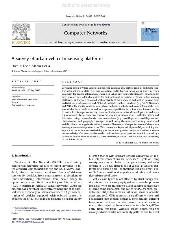
 Earth Entertainment channel