Shared description
River Garavogue
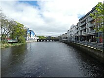
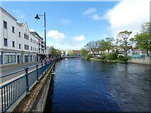
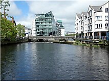
The Garavogue or Garvoge (Irish: An Gharbhóg) was known historically as the Sligeach or Sligo River. The river gave its name firstly to the town that grew up on its banks from the 13th century, and then to the county that was established in the late 16th and early 17th century. By the time of early Ordnance Survey work in the 19th century, the common name had become the Garavogue, at least for the river from Lough Gill to below the bridge in the town of Sligo. From Lough Gill, the Garavogue winds through Sligo town and flows into Sligo Bay. This pre-tidal course is less than two miles (3.2 km) long, making it possibly the shortest significant river in Ireland.[6] The river's estuary continues for roughly four miles (6.4 km) out to Rosses Point.
Created: Sun, 4 Jun 2023, Updated: Sun, 4 Jun 2023
6 images use this description:


Shared descriptions
This shared description
The 'Shared Description' text on this page is © copyright 2023 Gerald England.
Shared descriptions are specifically licensed so that contributors can reuse them on their own images, without restriction.
About shared descriptions
These Shared Descriptions are common to multiple images.
For example, you can create a generic description for an object shown in a photo, and reuse the description on all photos of the object. All descriptions are public and shared between contributors, i.e. you can reuse a description created by others, just as they can use yours.
Explore images
View images using this "River Garavogue" Shared Description
View images mentioning the words [River Garavogue] anywhere in text
Links for G69273593
This description is located in G69273593.
Other shared descriptions
Search for other Shared Descriptions.