


ISPRS Int. J. Geo-Inf. 2024, 13(7), 257; https://doi.org/10.3390/ijgi13070257 - 17 Jul 2024
Abstract
Exposure to PM2.5 pollution poses substantial health risks, with the precise quantification of exposure being fundamental to understanding the environmental inequalities therein. However, the absence of high-resolution spatiotemporal ambient population data, coupled with an insufficiency of attribute data, impedes a comprehension of
[...] Read more.
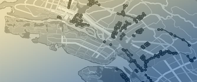
Exposure to PM2.5 pollution poses substantial health risks, with the precise quantification of exposure being fundamental to understanding the environmental inequalities therein. However, the absence of high-resolution spatiotemporal ambient population data, coupled with an insufficiency of attribute data, impedes a comprehension of the environmental inequality of exposure risks at a fine scale. Within the purview of a conceptual framework that interlinks social strata and citizenship identity with environmental inequality, this study examines the environmental inequality of PM2.5 exposure with a focus on the city of Xi’an. Quantitative metrics of the social strata and citizenship identities of the ambient population are derived from housing price data and mobile phone big data. The fine-scale estimation of PM2.5 concentrations is predicated on the kriging interpolation method and refined by leveraging an advanced dataset. Employing geographically weighted regression models, we examine the environmental inequality pattern at a fine spatial scale. The key findings are threefold: (1) the manifestation of environmental inequality in PM2.5 exposure is pronounced among individuals of varying social strata and citizenship identities within our study area, Xi’an; (2) nonlocal residents situated in the northwestern precincts of Xi’an are subject to the most pronounced PM2.5 exposure; and (3) an elevated socioeconomic status is identified as an attenuating factor, capable of averting the deleterious impacts of PM2.5 exposure among nonlocal residents. These findings proffer substantial practical implications for the orchestration of air pollution mitigation strategies and urban planning initiatives. They suggest that addressing the wellbeing of the marginalized underprivileged cohorts, who are environmentally and politically segregated under the extant urban planning policies in China, is of critical importance.
Full article
(This article belongs to the Special Issue HealthScape: Intersections of Health, Environment, and GIS&T)
►
Show Figures

Figure 1


