Year 10 presentation
- 1. The human and physical features of Bangladesh By Dan, Louis and Hagen
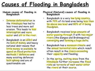
- 2. Physical features • Due where it is situated, Bangladesh is vulnerable to two types of flooding caused by physical features: Coastal and river flooding. Coastal because it is situated near the coast and river flooding as a large percentage of the country's population live on the flood plains of three large rivers- Brahmaputra, Ganges and Meghna. These are other physical features of Bangladesh: • Melting of snow from the Himalayas adds to the volume of water in warmer months • Deforestation in the Himalayas increases surface runoff • Increased surface runoff leads to soil erosion and more silt rising river beds. • The bed of Brahmaputra rises 5cm a year • 70 % of total land area is less than 1m above sea level meaning nowhere for water to drain • Confluence of three huge rivers increases flood risk
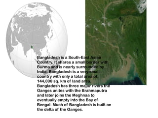
- 3. Location: Southern Asia, bordering the Bay of Bengal, between Burma and India Map references: Asia Area: total: 144,000 sq km land: 133,910 sq km water: 10,090 sq km Land boundaries: total: 4,246 km border countries: Burma 193 km, India 4,053 km Coastline: 580 km
- 4. • • Climate: tropical; mild winter (October to March); hot, humid summer (March to June); humid, warm rainy monsoon (June to October) • • Terrain: mostly flat alluvial plain; hilly in southeast • • Elevation extremes: lowest point: Indian Ocean 0 m • highest point: Keokradong 1,230 m • • Natural resources: natural gas, arable land, timber, coal • • Land use: arable land: 55.39% • permanent crops: 3.08% • other: 41.53% (2005) • • Irrigated land: 47,250 sq. km (2003) • • Natural hazards: droughts, cyclones; much of the country routinely inundated during the summer monsoon season • • Environment - current issues: many people are landless and forced to live on and cultivate flood-prone land; water-borne diseases prevalent in surface water; water pollution, especially of fishing areas, results from the use of commercial pesticides; ground water contaminated by naturally occurring arsenic; intermittent water shortages because of falling water tables in the northern and central parts of the country; soil degradation and erosion; deforestation; severe overpopulation • • Environment - international agreements: party to: Biodiversity, Climate Change, Climate Change-Kyoto Protocol, Desertification, Endangered Species, Environmental Modification, Hazardous Wastes, Law of the Sea, Ozone Layer Protection, Wetlands • signed, but not ratified: none of the selected agreements • • Geography - note: most of the country is situated on deltas of large rivers flowing from the Himalayas: the Ganges unites with the Jamuna (main channel of the Brahmaputra) and later joins the Meghna to eventually empty into the Bay of Bengal •
- 5. Capital: Dhaka (Dacca) Population: 157.5 million (2006) Size: 147,570 square kilometres (about half the size of the UK) Language: Bengali (Bangla); Urdu and Hindi are minority languages and English is also used Currency: 1 taka = 100 paisa (poisha) Average life expectancy: Overall, 63.3 years. Male 62.5 years, Female 62.5 years (2006) Number of doctors: 26 physicians per 100,000 people (2006) Literacy: Overall, 41.1%. Male 50.3%, Female 31.4% (2005) Population with access to safe water: 74% have access to improved water sources Number of internet users: 2 per 1000 people (2006) Here are some human characteristics of Bangladesh
- 6. Bangladesh is a South-East Asian Country. It shares a small border with Burma and is nearly surrounded by India. Bangladesh is a very small country with only a total area of: 144,000 sq. km of land area. Bangladesh has three major rivers the Ganges unites with the Brahmaputra and later joins the Meghnaa to eventually empty into the Bay of Bengal. Much of Bangladesh is built on the delta of the Ganges.
- 7. BY GUY, ABI, JADE.
- 10. • 90% of the yearly rainfall happens in the monsoon season (June-October) • The typhoon season also contributes to the flooding this is between August and November. • The main floods in the 20th century happened in 1987, 1988, 1998 and more recently in 2007. This serves to illustrate just how, common these floods are.
- 12. Causes of Flooding Physical Causes • 80% of the country is a huge flood plain • 70% of the total area about 1 metre above sea level • 10% of the land area is made up of lakes and rivers • Snowmelt from the Himalayas • Bangladesh experiences heavy monsoon rains and tropical storms which bring heavy rains and coastal flooding, • Long period of heavy rain caused all three rivers to have their peak flow at the same time. Human Causes • Deforestation in Nepal and the Himalayas • Dams built in India which increased sedimentation • Urbanisation of the flood plain • Global warming • Poorly maintained embankments that collapse in times of heavy floods
- 13. Effects of the 1998 flood • Negative effects of the flood include over two thirds of Bangladesh covered by water, Dhaka was submerged under two metres of water, one million made homeless, death toll just over a thousand, contamination of crops and animals, unclean water resulting in cholera and typhoid, very few hospitals where functional, those that were had too many patients which resulted in everyday injuries becoming fatal, over six hundred thousand hectares of crops destroyed, 400 factories forced to close, a twenty per cent decrease in production and communications became difficult.
- 14. Positives of the flood • Positive effects of the flood were deposition of fertile soil, which meant better soil for crops, and deposition of silt, which created land for houses. • This deposition of silt also creates land upon which people can live - for example the Ganges delta has been formed in this way as deposition has occurred where the river has entered the Bay of Bengal.
- 15. Bangladesh Flood 2004 By Chloe.B, Charlotte.f, Kyran.R, Adam.H & Chloe.K.
- 16. Causes Of The Floods. • Tectonic uplift of the Himalayas means that erosion rates of sediment increase as the rivers have more potential for erosion. • Mass of sediment is dumped in Bangladesh choking the river channels making them more inefficient and reducing hydraulic radius. Sediment is dumped and flooding can occur. • Deforestation of the Himalaya – reducing interception rates which means shorter lag time and higher peak discharges. • Cyclones from the Bay of Bengal cause and contribute to coastal flooding.
- 17. Effects • The 2004 floods lasted from July to September and covered 50% of the country at their peak. • At the time of the July 2004 floods 40% of the capital, Dhaka was under water. • 600 deaths were reported and 30million people were homeless. • 100,000 people alone in Dhaka suffered from diarrhoea from the flood waters.
- 18. Records show that the frequency and scale of the floods in Bangladesh has increased over the last 50 years. The costs to fix the damage after the floods has slowly increased after the past few years. Since the floods the houses have been raised from ground level to protect peoples homes. Better flood defences are needed although they cost too much; they also create environmental problems.
- 19. The Causes of the flooding in 2007 • Bangladesh floods 2007 • Natural Events • Abnormal Monsoon Patterns • Snow Melt on Himalayas
- 20. Effects • heavy monsoon rains filled the Brahmaputra, Padma, and Meghna Rivers, • Total fatalities to date 323 up to 11th August 2007. • More than 9.5 million people have been badly affected • Floods water are receding fast • 1,000 patients have been admitted to International Centre for Diarrhoeaal Disease Research, • Approximately 1.5 million acres of agricultural crops • 532 educational institutions completely destroyed and 5608 partially damaged. • 2,817 km roads completely and 17,463 roads partially damaged • Over 89,000 homes completely and over 650,000 homes partially destroyed • Floods waters continue to inundate much of the low-lying eastern part of Dhaka City and many people have taken shelter in government offices and schools.
Editor's Notes
- Bangladesh - number of problems with flooding as a nation – more than any other country in the world. Fewdifferent causes - combination of different factors create a near constant danger of floods in the nation. The Ganges River essentially breaks apart and flows - many smaller rivers as it feeds into the ocean. Bangladesh is mostly a tributary system of rivers – theses are not well organized with flood controls - not many modern dikes, floodgates or dams to control the water when it begins to rise.Bangladesh sits at a geographic point - receives a high degree of rainfall regularly often during the monsoon season. These heavy rainfalls overflow the rivers and streams throughout the nation - contributing to the problem; the snow that melted that occurs every Spring in the Himalayan Mountains. Normally, when there is heavy rainfall,the rivers are swollen with melted snow - from the Himalayas -same time -combination results in massive, predictable flooding.
- snowmelt from the Himalayas takes place in late spring and summerLong period of heavy rain caused all three rivers to have their peak flow at the same time.Global Warming (increase in snowmelt, sea level and rainfall), Deforestation in Nepal and the Himalayas so there is less infiltrationDams built in India which increased sedimentation – less space for water to flow
- Negative effects of the flood include over two thirds of Bangladesh covered by water, Dhaka was submerged under two metres of water, one million made homeless, death toll just over a thousand, contamination of crops and animals, unclean water resulting in cholera and typhoid, few hospitals functional, those that were had too many patients which resulted in everyday injuries becoming fatal, over six hundred thousand hectares of crops destroyed, 400 factories forced to close, a twenty per cent decrease in production and communications became difficult.
- Following the 1998 floods a number of short term flood relief measures were put in place to try and minimise loss of life - these included: international food aid programmes the distribution of free seed to farmers by the Bangladesh government to try and reduce the impact of food shortages - the government also gave 350,000 tonnes of cereal to feed people; volunteers / aid workers worked to try and repair flood damage
- Since Bangladesh suffered from the major flood in 2004, it’s tried a few ways to prevent the floods from being as bad in the future. Although Bangladesh already had flood protection embankments, they were not strong enough to prevent the water from over topping them. Even now, when Bangladesh has better Flood protection measures, the costs to fix the damage has steadily increased over the past few years.Bangladesh have built cluster villages to try to lower the chance of people losing their homes due to flooding. A cluster village houses about 30 families, and the houses are raised 2metres above the water level.They’ve also invested in rescue boats that are located around the areas that are most at risk of flooding, and in the areas near to flood shelters. The government of Bangladesh have also insured that individual homes have been lifted 2metres above the water level on earth banks, these earth banks have been planted with grass to prevent any erosion.
- The causes of the flooding in Bangladesh in 2007 is the mixture of a few natural events. Abnormal monsoon patterns mixed with the snow melt on the Himalayas being faster than usual cause these floods.
- heavy monsoon rains filled the Brahmaputra, Padma, and Meghna Rivers,* Total fatalities to date 323 up to 11th August 2007. More than 9.5 million people have been badly affected by the floods which has damaged their homesteads, livelihoods and impacted on their health. Floods water are receding fast and flood-affected families are gradually returning to their flood-ravaged homes and land.1,000 patients have been admitted to International Centre for Diarrhoeaal Disease Research, Approximately 1.5 million acres of agricultural crops (seedbeds, transplanted seedlings, vegetables and standing jutes) are partially or fully damaged, the approximate worth over 150 million BDT. 532 educational institutions completely destroyed and 5608 partially damaged. 2,817 km roads completely and 17,463 roads partially damaged Over 89,000 homes completely and over 650,000 homes partially destroyed Floods waters continue to inundate much of the low-lying eastern part of Dhaka City and many people have taken shelter in government offices and schools. There is a shortage of food, and drinking water. Many people affected by flooding in-city have fallen sick with water-borne diseases.


