Artículos y etnografías by César I Borie
Iguales pero Diferentes. Trayectorias históricas prehispánicas en el Cono Sur, 2020
 Bookmarks Related papers MentionsView impact
Estudios Atacameños, 2020
Este artículo explora las características particulares de las prácticas musicales desplegadas por... more Este artículo explora las características particulares de las prácticas musicales desplegadas por los músicos de la banda de bronces Alcones del Folklore, con especial énfasis en su repertorio. Para ello se realizó un repaso de la evolución histórica de las bandas de bronces en el Norte Grande de Chile y se hizo trabajo de campo junto a dicha banda. Además, fueron considerados datos arqueológicos, etnohistóricos y etnográficos relativos a la asociación entre música y ritual en ceremonias religiosas de los Andes centro-sur desde tiempos prehispánicos hasta el presente.
Se plantea que a través de sus prácticas musicales, las bandas de bronces andinas participan en la continuidad y cambio de un entramado de relaciones musicales, devocionales y espacio-temporales, de identidades y memorias colectivas, las cuales persisten desde tiempo preincaicos y han incorporado tenazmente sonidos y devociones más recientes.
Dichas prácticas entretejen versatilidad, tradición y modernidad dentro de relaciones de correspondencia, tal como revisaremos para el caso de Alcones del Folklore, durante la festividad de Espíritu Santo, en el poblado de Jaiña (Tarapacá, Norte Grande de Chile), los años 2014 y 2015.
Bookmarks Related papers MentionsView impact Revista Fogón, 2018
El artículo ofrece una síntesis de datos etnohistóricos, etnográficos y arqueológicos, registrado... more El artículo ofrece una síntesis de datos etnohistóricos, etnográficos y arqueológicos, registrados entre la costa norte del Perú y extremo sur de Chile, referidos al aprovechamiento de algas marinas por diferentes grupos humanos vinculados a la explotación de recursos del mar. Se entrega un conjunto de datos que contribuyen para una comprensión más integral del uso de ese tipo particular de recurso renovable entre los grupos costeros prehispánicos y actuales, demostrando la continuidad histórica de los modos de vida asociados a la recolección de algas. Finalmente, se presentan algunas reflexiones en torno al papel secundario y marginal de la recolección de algas en las investigaciones arqueológicas y antropológicas, sus posibles motivaciones e implicancias.
Bookmarks Related papers MentionsView impact
Bookmarks Related papers MentionsView impact Estudios de Arqueología, Historia, Filosofía y Ciencias Sociales en Homenaje a Mario Orellana Rodriguez, 2017
Explica la arqueología de la pampa del desierto de atacama en el periodo de los cazadores-recolec... more Explica la arqueología de la pampa del desierto de atacama en el periodo de los cazadores-recolectores, en donde se describe el uso del territorio y la reconstrucción paleoclimática asociada.
Bookmarks Related papers MentionsView impact Revista Chilena de Antropología Visual, Nº5, pp. 152-179. Universidad Academia de Humanismo Cristiano, Santiago de Chile, 2005
En San Miguel de Azapa, (valle del mismo nombre, en la 1 Región) cada 1º de noviembre los deudos ... more En San Miguel de Azapa, (valle del mismo nombre, en la 1 Región) cada 1º de noviembre los deudos acuden al cementerio a compartir con sus difuntos. Familias enteras viajan hasta allí desde el interior de Tarapacá o desde lejanas ciudades especialmente para celebrar ese día para los muertos. Los deudos se presentan con sus mejores ropas, con su mejor actitud, gastan en comida y bebida en favor de su finado, arreglan y adornan tumbas y nichos. Convocan a bandas para satisfacer las necesidades musicales de aquellos que ya fallecieron.
Bookmarks Related papers MentionsView impact 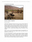
Revista Chilena de Antropología Visual, Nº7, pp. 114-135. Universidad Academia de Humanismo Cristiano, Santiago de Chile, Jun 2006
En enero de este año, recorrimos el interior del valle de Copiapó siguiendo las señales dejadas p... more En enero de este año, recorrimos el interior del valle de Copiapó siguiendo las señales dejadas por don Hans Niemeyer en sus notas de campo. La intención era recorrer las quebradas que alimentan el río Copiapó, poniendo atención a los sitios arqueológicos y los asentamientos humanos contemporáneos.
Las pistas dejadas por Niemeyer nos permitieron llegar fácilmente a la casa de su arriero y amigo: don Sixto Aróstica. En adelante, nos movimos por esas alturas poniendo atención a las palabras de aquel viejo sabio y cariñoso que apadrinó a esta tropa de buitres hambrientos bajo la sombra de su añosa higuera.
El último día de nuestro viaje, fuimos convidados a la señalada, cuando ellos marcan el nuevo ganado con un corte en la oreja, en los Ojos de Agua del Montosa. Esta etnografía visual recoge esa experiencia, una entrada inesperada en el mundo arriero, un momento familiar, una invitación que aún no alcanzamos a agradecer.
Bookmarks Related papers MentionsView impact 
Revista Chilena de Antropología Visual, Nº 7, pp 7-23 . Universidad Academia de Humanismo Cristiano, Santiago de Chile, Dec 2006
Cada 1° de noviembre en Azapa, poblado del norte de Chile, los deudos llevan música y comida al c... more Cada 1° de noviembre en Azapa, poblado del norte de Chile, los deudos llevan música y comida al cementerio para celebrar con sus difuntos el Día de Todos los Muertos. Un acercamiento antropológico a esta celebración ha motivado una exploración metodológica, actualmente en curso, para abordar etnográficamente un tema poco trabajado en nuestro país -la relación fiesta/muerte- utilizando nuevas tecnologías audiovisuales e hipermediales. La falta de un marco teórico sólido con respecto a la aplicación de la tecnología audiovisual en antropología, la carencia de referentes prácticos similares y la poca experiencia del equipo investigador confabularon para darle a este trabajo el carácter de exploratorio. Por ello se buscó explotar al máximo las potencialidades de la metodología utilizada en relación al tema abordado, y sacar a la luz sus limitaciones, para obtener los mejores resultados posibles. Esta presentación apunta a resaltar los aspectos metodológicos de esta experiencia, utilizando el caso del estudio de esta celebración como un ejemplo, aprovechando las nuevas tecnologías disponibles a modo de soporte para la recolección de datos, su almacenamiento y procesamiento, así como para la generación de productos etnográficos y su difusión. La reflexión se moverá en dos ejes que corresponden a dos etapas: primero, las actividades realizadas en terreno, luego el momento del análisis y la generación de resultados.
Bookmarks Related papers MentionsView impact Revista Chilena de Antropología Visual, Nº10, pp. 189-206. Universidad Academia de Humanismo Cristiano, Santiago de Chile, Dec 2007
Los Payachatas: Música, concepto y mito. Un ejercicio de montaje e interpretación privilegiando l... more Los Payachatas: Música, concepto y mito. Un ejercicio de montaje e interpretación privilegiando la expresión directa de los músicos, multiinstrumentistas, maestros del folklore andino. Imágenes, voces, un sentimiento, día a día más cerca del Altiplano, con cada amanecer una nueva historia. A tres años de la muerte de su fundador, esta expresión épica de arte se tensa, crece, cambia. Amor y alegría, rencores y dolores: retazos coloridos cosidos con cariño.
Bookmarks Related papers MentionsView impact Libros by César I Borie

Mining and Quarrying in the Ancient Andes. Interdisciplinary Contributions to Archaeology, 2012
In this paper we reconsider our previous interpretation on Inca control over the San José del Abr... more In this paper we reconsider our previous interpretation on Inca control over the San José del Abra copper mines in northern Chile by evaluating new evidence that comes from recent research into the sociopolitical and ideological dimensions of mining during the Late Period. Our data show that two mining complexes in the study area were directly controlled by the state through diverse means, including (1) the financing of the operations; (2) the spatial concentration of production and the mining community; (3) the materialization and reproduction of sociopolitical differences within the mining community between the state’s representatives and the local workers; (4) the Inca mediation between the miners and the supernatural beings that probably control mining safety and fertility; and (5) the creation of a regional sacred landscape centered around mining and materialized through state symbols and state-controlled practices.
Bookmarks Related papers MentionsView impact 
Este libro presenta diversas aproximaciones, desde las ciencias sociales y las artes, a los lakit... more Este libro presenta diversas aproximaciones, desde las ciencias sociales y las artes, a los lakitas en la ciudad de Arica (Norte Grande de Chile). Las lakitas o zampoñas son aerófonos. Se tocan en pares de primera y segunda. La escala musical se dispone con las notas intercaladas sucesivamente entre ambas. Primera y segunda son tocados por dos intérpretes enfrentados que sostienen un diálogo musical, a manera de que se escuche “una sola voz”. Una voz que se escucha en los Andes hace miles de años, pues si bien su materialidad ha variado (cerámica, hueso, metal, caña y polímero plástico), se trata de una manera profundamente andina de pensar, experienciar y hacer música. Donde destaca la plasticidad del instrumento, sus intérpretes y su propia historia. Roncan en devociones religiosas, reuniones políticas, locales comerciales y eventos familiares; soplan por dolor, muerte, gloria y lluvia; e incorporan sagazmente ritmos, tecnologías y estilos. Porque las lakitas no son sólo sonido, son también cuerpo, visualidad, memoria y creatividad.
Bookmarks Related papers MentionsView impact Conference Presentations by César I Borie
Actas del XXI Congreso Nacional de Arqueología Chilena. Simposio X: La Dimensión Espacial de la Tecnología Lítica, 2018
Se presentan los resultados a la fecha de una estrategia de investigación interdisciplinaria para... more Se presentan los resultados a la fecha de una estrategia de investigación interdisciplinaria para la reconstrucción del paisaje lítico del desierto interior de Taltal-Paposo. Esta estrategia integra herramientas SIG, teledetección satelital y trabajo de campo arqueológico para el rastreo de áreas fuente de materias primas silíceas/silicificadas en el sector sur del desierto de Atacama.
Bookmarks Related papers MentionsView impact Paper presented at the SAA 80th Annual Meeting
Bookmarks Related papers MentionsView impact The poster summarizes the methodological process for the detailed documentation of a vast complex... more The poster summarizes the methodological process for the detailed documentation of a vast complex of late Prehispanic agrarian elements (fields, irrigation canals) in the deserted area of Atacama (northern Chile). As opposed to the usual conditions for prospection in temperate regions, where the visibility of archaeological features is usually poor and confusing, here the extreme dryness of the landscape allowed an extraordinary preservation and visibility of fields, canals and other constructions.
The main result has been the construction of a highly detailed and accurate map of a complex group of archaeological structures, which has been used since for the analysis and interpretation of the area, and also for the design of new fieldwork seasons.
Bookmarks Related papers MentionsView impact 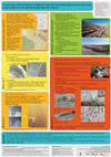
The poster will summarize the methodological process for the detailed documentation of a vast com... more The poster will summarize the methodological process for the detailed documentation of a vast complex of late Prehispanic agrarian elements (fields, irrigation canals) in the deserted area of Atacama (northern Chile). As opposed to the usual conditions for prospection in temperate regions, where the visibility of archaeological features is usually poor and confusing, here the extreme dryness of the landscape allowed an extraordinary preservation and visibility of fields, canals and other constructions.
The approach was initially based on a combination of visual interpretation of high resolution satellite images (GeoEye 1) and fieldwork for mapping the layout and shape of most of the elements (canals, groups of fields, settlement areas). For the accurate documentation of smaller or densely built areas, an SFM-based photogrammetry approach was carried out, based on the use of a low cost UAV (Dji Phantom) and a consumer-grade compact digital camera for the acquisition of low altitude aerial images that allowed the generation of 3D models and orthoimages of some areas. Finally, ground based photogrammetry was also used to capture and represent some elements in greater detail.
The main result has been the construction of a highly detailed and accurate map of a complex group of archaeological structures, which has been used since for the analysis and interpretation of the area, and also for the design of new fieldwork seasons.
Bookmarks Related papers MentionsView impact Papers by César I Borie
Bookmarks Related papers MentionsView impact 
Estudios Atacamenos, 2020
Este artículo explora las características particulares de las prácticas musicales desplegadas por... more Este artículo explora las características particulares de las prácticas musicales desplegadas por los músicos de la banda de bronces Alcones del Folklore, con especial énfasis en su repertorio. Para ello se realizó un repaso de la evolución histórica de las bandas de bronces en el Norte Grande de Chile y se hizo trabajo de campo junto a dicha banda. Además, fueron considerados datos arqueológicos, etnohistóricos y etnográficos relativos a la asociación entre música y ritual en ceremonias religiosas de los Andes centro-sur desde tiempos prehispánicos hasta el presente. Se plantea que a través de sus prácticas musicales, las bandas de bronces andinas participan en la continuidad y cambio de un entramado de relaciones musicales, devocionales y espacio-temporales, de identidades y memorias colectivas, las cuales persisten desde tiempo preincaicos y han incorporado tenazmente sonidos y devociones más recientes. Dichas prácticas entretejen versatilidad, tradición y modernidad dentro de re...
Bookmarks Related papers MentionsView impact Quaternary International
Bookmarks Related papers MentionsView impact Estudios atacameños, 2017
Bookmarks Related papers MentionsView impact Diálogo andino, 2016
Bookmarks Related papers MentionsView impact 
Uploads
Artículos y etnografías by César I Borie
Se plantea que a través de sus prácticas musicales, las bandas de bronces andinas participan en la continuidad y cambio de un entramado de relaciones musicales, devocionales y espacio-temporales, de identidades y memorias colectivas, las cuales persisten desde tiempo preincaicos y han incorporado tenazmente sonidos y devociones más recientes.
Dichas prácticas entretejen versatilidad, tradición y modernidad dentro de relaciones de correspondencia, tal como revisaremos para el caso de Alcones del Folklore, durante la festividad de Espíritu Santo, en el poblado de Jaiña (Tarapacá, Norte Grande de Chile), los años 2014 y 2015.
Las pistas dejadas por Niemeyer nos permitieron llegar fácilmente a la casa de su arriero y amigo: don Sixto Aróstica. En adelante, nos movimos por esas alturas poniendo atención a las palabras de aquel viejo sabio y cariñoso que apadrinó a esta tropa de buitres hambrientos bajo la sombra de su añosa higuera.
El último día de nuestro viaje, fuimos convidados a la señalada, cuando ellos marcan el nuevo ganado con un corte en la oreja, en los Ojos de Agua del Montosa. Esta etnografía visual recoge esa experiencia, una entrada inesperada en el mundo arriero, un momento familiar, una invitación que aún no alcanzamos a agradecer.
Libros by César I Borie
Conference Presentations by César I Borie
The main result has been the construction of a highly detailed and accurate map of a complex group of archaeological structures, which has been used since for the analysis and interpretation of the area, and also for the design of new fieldwork seasons.
The approach was initially based on a combination of visual interpretation of high resolution satellite images (GeoEye 1) and fieldwork for mapping the layout and shape of most of the elements (canals, groups of fields, settlement areas). For the accurate documentation of smaller or densely built areas, an SFM-based photogrammetry approach was carried out, based on the use of a low cost UAV (Dji Phantom) and a consumer-grade compact digital camera for the acquisition of low altitude aerial images that allowed the generation of 3D models and orthoimages of some areas. Finally, ground based photogrammetry was also used to capture and represent some elements in greater detail.
The main result has been the construction of a highly detailed and accurate map of a complex group of archaeological structures, which has been used since for the analysis and interpretation of the area, and also for the design of new fieldwork seasons.
Papers by César I Borie
Se plantea que a través de sus prácticas musicales, las bandas de bronces andinas participan en la continuidad y cambio de un entramado de relaciones musicales, devocionales y espacio-temporales, de identidades y memorias colectivas, las cuales persisten desde tiempo preincaicos y han incorporado tenazmente sonidos y devociones más recientes.
Dichas prácticas entretejen versatilidad, tradición y modernidad dentro de relaciones de correspondencia, tal como revisaremos para el caso de Alcones del Folklore, durante la festividad de Espíritu Santo, en el poblado de Jaiña (Tarapacá, Norte Grande de Chile), los años 2014 y 2015.
Las pistas dejadas por Niemeyer nos permitieron llegar fácilmente a la casa de su arriero y amigo: don Sixto Aróstica. En adelante, nos movimos por esas alturas poniendo atención a las palabras de aquel viejo sabio y cariñoso que apadrinó a esta tropa de buitres hambrientos bajo la sombra de su añosa higuera.
El último día de nuestro viaje, fuimos convidados a la señalada, cuando ellos marcan el nuevo ganado con un corte en la oreja, en los Ojos de Agua del Montosa. Esta etnografía visual recoge esa experiencia, una entrada inesperada en el mundo arriero, un momento familiar, una invitación que aún no alcanzamos a agradecer.
The main result has been the construction of a highly detailed and accurate map of a complex group of archaeological structures, which has been used since for the analysis and interpretation of the area, and also for the design of new fieldwork seasons.
The approach was initially based on a combination of visual interpretation of high resolution satellite images (GeoEye 1) and fieldwork for mapping the layout and shape of most of the elements (canals, groups of fields, settlement areas). For the accurate documentation of smaller or densely built areas, an SFM-based photogrammetry approach was carried out, based on the use of a low cost UAV (Dji Phantom) and a consumer-grade compact digital camera for the acquisition of low altitude aerial images that allowed the generation of 3D models and orthoimages of some areas. Finally, ground based photogrammetry was also used to capture and represent some elements in greater detail.
The main result has been the construction of a highly detailed and accurate map of a complex group of archaeological structures, which has been used since for the analysis and interpretation of the area, and also for the design of new fieldwork seasons.
Este trabajo desarrolla una sistematización de la información arqueológica disponible para el área de estudio y una propuesta metodológica dirigida al rastreo remoto de las potenciales áreas fuente de aprovisionamiento lítico arcaico. Adicionalmente, se presentan los primeros resultados de las labores de reconocimiento en la Depresión Intermedia de Taltal y del análisis de imágenes satelitales multiespectrales.
Siliceous raw materials played a key role in the technological organization of Taltal’s archaic populations, as witnessed by its ubiquity in the local archaeological sites. Nevertheless, crucial aspects like their sources and the strategies deployed for their procurement have been referred only tangentially in the archaeological literature of the area.
This work develops a systematization of the archaeological data available for the study area and a methodological proposal for the remote tracking of potential archaic quarries. Additionally, the first results of field surveying in Taltal’s Intermediate Depression and the analysis of multispectral satellite imagery is presented.
Contrating the image of desolation and hostility implanted on the Atacama's Intermediate Depression through the concept of wilderness, the altitudinal transect linking Calama and Cobija stands in the light of historical and archaeological research as a scenario in which different human groups deployed over time various strategies of dwelling and travelling, communicating the coastal desert, the Middle Loa basin and the inner oasis of the Antofagasta Region. Integrating strategies for data gathering and analysis methodologies, including the study of historical chronicles and maps, archaeological surveys and the use of geographic information technologies, highway landscapes shaped by the movement of people and goods through this internodal space in historical times are addressed, relieving information regarding their realization in concrete transit routes and the socioeconomic, environmental and technological factors that marked their emergence, use, restructuring and neglect.
ABSTRACT The present work describes a new site with El Medano style rock art identified in the framework of systematic surveys in the Taltal's intermediate depression. The site, called Quebrada Portezuelo 22, is located 37 km east of the coast, corresponding until now to the site farthest from the coastline with this type of pictographs. It presents the description of
por las particulares condiciones ambientales de la zona, el trabajo de mapeo y documentación allí realizado se basó inicialmente en una combinación del empleo de imágenes de satélite de alta resolución espacial (GeoEye 1) y trabajo de prospección en campo.
Con ello se logró una detallada documentación de los espacios en estudio, aunque limitada por la falta de detalle suficiente de las imágenes de satélite en algunas áreas concretas. Para complementar ese trabajo con una aproximación más detallada, se realizó una documentación basada en técnicas de computer vision (Structure From
Motion) a partir de fotografías tomadas desde un UAV sencillo y de bajo coste. Con estas fotografías se produjeron modelos 3D y ortoimágenes de gran resolución de áreas de cultivo y asentamientos.
La principal contribución ha sido la producción de documentos planimétricos de gran detalle y precisión de un extenso conjunto de elementos arqueológicos, que han servido tanto para entender mejor estos espacios como para diseñar y planificar futuras campañas de trabajo de campo.
En este artículo describimos el proceso de trabajo y realizamos una valoración de la relación entre tiempo de trabajo – recursos técnicos empleados – condiciones del trabajo – resultados obtenidos. Además, comparamos el proceso de trabajo y los resultados obtenidos con dos equipos diferentes.
This issue of Estudios Atacameños presents the results of the symposium referred to in the title of this Introduction. The symposium took place on October 8, 2015 in the city of Concepción during the XX National Conference of Chilean Archaeology, and was organized by the Universidad de Concepción Anthropology Program and the Chilean Archaeology Society. On that occasion, 16 papers were presented by more than 30 researchers from Chile, Argentina and the United States. Axel Nielsen provided comments at the end of the symposium.