Research Interests:
Research Interests:
Research Interests:
Research Interests:
Research Interests:
Research Interests:
Research Interests:
Research Interests:
Research Interests:
Research Interests:
Research Interests:
The Worked Bone Research Group (WBRG) is an official Working Group of the International Council for Archaeozoology (ICAZ) since June 2000.
Find out more here: https://www.wbrg.net/
Find out more here: https://www.wbrg.net/
Research Interests:
Different approaches and challenges, sharing experiences but reaching the same goal-a better understanding and raised awareness of hidden archaeological heritage and its protection by presenting it via new information and communication... more
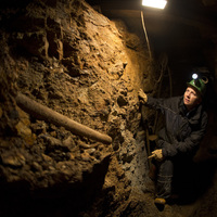
Different approaches and challenges, sharing experiences but reaching the same goal-a better understanding and raised awareness of hidden archaeological heritage and its protection by presenting it via new information and communication technologies like VR/AR. That´s the main background of the EU-project "VirtualArch-Visualize to Valorize", running from July 2017 to June 2020. 10 partners from 8 central European countries try to elaborate a transnational strategy to valorize hidden archaeological monuments by visualizing them. Therefore, 8 selected pilot sites were digitized/visualized and presented to stakeholders via guided field tours and information points on spot. The pilot sites are presenting different archaeological types, forms and periods like prehistoric and medieval mines, roman and medieval harbours as well as cultural landscapes with prehistoric pile dwellings or urban archaeology with huge and complex stratigraphy. This includes also different areas and environments, impacts and audiences. Although the project is still in its first half, the session seems to be a perfect area to present project and its actors as well as share first experiences with all present professionals and experts.
Research Interests:
Research Interests:
Research Interests:
Research Interests:
Research Interests:
Co-Autoreninnen: Susanne Schöne und Petra Schug
Research Interests:
Research Interests:
weitere Co-Autoren: Silvio bock, Martin Volf
Katalog zur Ausstellung "Sachen Böhmen 7000"
Sprache: deutsch-tschechisch
Katalog zur Ausstellung "Sachen Böhmen 7000"
Sprache: deutsch-tschechisch
Research Interests:
Das EU-Projekt VirtualArch und der Einsatz von virtueller Realität
Research Interests:
weitere Co-Autoren: Frank Schröder, Alexander Fülling, Susann Heinrich, Heide Hönig
Research Interests:
weitere Co-Autoren: Susann Heinrich, Franziska D.H. Wilke, Frank Schröder, Roman Krivánek, Lars Schulz, Alexander Bonhage
Research Interests:
Ausstellungsband, Museum für Vor- und Frühgeschichte, Staatliche Mussen zu Berlin: Bewegte Zeiten. Archäologie in Deutschland, S 254 - 266
Co-Autorinnen: Ivonne Burghardt, Gabriele Wagner , Joanna Wojnicz
Co-Autorinnen: Ivonne Burghardt, Gabriele Wagner , Joanna Wojnicz
Research Interests:
in: Ausgrabungen in Sachsen ( AiS 6)
weitere Co-Autoren: Frank Schröder, Heide Hönig
weitere Co-Autoren: Frank Schröder, Heide Hönig
Research Interests:
in: Ausgrabung in Sachsen (AiS 6)
Co-Autoren: Christoph Herbig, Anja Kalofen, Sonja Matson, Matthias Schubert, Johann Friedrich Tolksdorf
Co-Autoren: Christoph Herbig, Anja Kalofen, Sonja Matson, Matthias Schubert, Johann Friedrich Tolksdorf
Research Interests: Ausgrabungen and Freiberg
in: Ausgrabungen in Sachsen (AiS 6) S. 229-238
Research Interests:
Die Ermordung des Nürnberger Bürgers Johann Wengenmair in der erzgebirgischen Stadt Annaberg am 2. Juni 1514 fand im Verlauf der Jahrhunderte mehrfach Rezeption in Chroniken und Sagen. Am 26. April 2017 wurden bei Ausgrabungen des... more
Die Ermordung des Nürnberger Bürgers Johann Wengenmair in der erzgebirgischen Stadt Annaberg am 2. Juni 1514 fand im Verlauf der Jahrhunderte mehrfach Rezeption in Chroniken und Sagen. Am
26. April 2017 wurden bei Ausgrabungen des Landesamtes für Archäologie Sachsen in einem Grab in der Kirche des ehemaligen Annaberger Franziskanerklosters die Gebeine eines männlichen Individuums entdeckt, das offenbar in Folge eines tätlichen Angriffs zu Tode gekommen war. Eine große Hiebverletzung am Hinterkopf, der sehr kurze Zeitraum der Kirchennutzung und die Lage des Grabes in der Nähe
des Chores gaben Anlass zu vermuten, dass es sich um die sterblichen Überreste des Nürnbergers Johann Wengemair handeln könnte. Historische Recherchen in Nürnberger und Annaberger Archiven führten zu detaillierten Angaben zu den Tatumständen sowie zu der Person und dem Wirken Johann Wengenmairs.
Ergänzt durch einen überregionalen Vergleich zeitgenössischer Bestattungsformen sowie anthropologische und paläomechanische Untersuchungen am Schädel des Ermordeten konnten Tathergang und Tatwaffe eingegrenzt werden. Mit hoher Wahrscheinlichkeit handelt es sich bei der männlichen Bestattung aus der Annaberger Klosterkirche mit dem Nürnberger Johann Wengenmair.
Research Interests:
In: Sonderdruck aus Archäologisches Korrespondenzblatt, Jahrgang 48, 2018, Heft 2
weitere Co-Autoren: Anja Kaltofen, Sonja Matson
weitere Co-Autoren: Anja Kaltofen, Sonja Matson
In: Forstjournal 2/2018, S. 27-31
Co-Autor: Jörg Fleischer, Heide Hönig
Co-Autor: Jörg Fleischer, Heide Hönig
In: Archäologie des Glaubens: Umbrüche und Konflikte. Mitteilungen der Deutschen Gesellschaft für Archäologie des Mittelalters und der Neuzeit (MDGAMN), 73-84
In: Klosterstift St. Marienthal. Flutschadenbeseitigung 2010-2017
In: Ausgrabungen in Sachsen 5 (AiS 5), S. 431-438
weiterer Co-Author: Heide Hönig
weiterer Co-Author: Heide Hönig
In: Archäologie in Sachsen 5 (AiS 5), S. 274-280
In: Mitteilungen der Deutschen Orient Gesellschaft (MDOC) 125, 1993, 113-131
In: Zeitschrift für Archäologie des Mittelalters 44 (2016), 167-198
In: Stadtsanierung Freiberg 1990 bis 2015 (2015), 32-34
In: Blickpunkt Archäologie 1/2015, 55-58
Co-Author: Wendy Eixler
Co-Author: Wendy Eixler
In: Ausgrabungen in Sachsen 4 (2014), 363-374
In: Ausgrabungen in Sachsen 4 (2014), 355-362
In: Ausgrabungen in Sachsen 4 (2014), 229-238
Co-Author: Susann Richter
Co-Author: Susann Richter
In: Ausgrabungen in Sachsen 3 (2012), 124-128
Co-Author: Ute Krämer
Co-Author: Ute Krämer
Colluvial sediments originating from soil erosion on slopes have proven to constitute significant evidence for tracing past human impact on mountain landscapes. In the Central European Erzgebirge (Ore) Mountains, colluvial sediments are... more
Colluvial sediments originating from soil erosion on slopes have proven to constitute significant evidence for tracing past human impact on mountain landscapes. In the Central European Erzgebirge (Ore) Mountains, colluvial sediments are associated with specific landforms (footslopes, slope flattenings, dells) and cover a share of 11% (11,905 ha) of the regional soil landscape. Thirteen pedosedimentary sections with colluvial layers were investigated at five forested sites (520–730 m a.s.l.) within a context of mining archaeology, integrating data from pedology, archaeology, palaeobotany, and geochronology. The thickness of the gravel-bearing loamy, silty, and sandy colluvial layers is up to 70 cm, which are mostly located on top of the sections. The geochronological ages and archaeological data reveal a high to late medieval to post-medieval age of the colluvial sediments. Pollen data show a drastic decline of the mountain forests in the late twelfth to fifteenth centuries AD accomp...
Research Interests: Archaeology and Geology
Research Interests:
Rezension zu: Medievalia Archaeologica, Bd. 1, hrsg. von Jan Klapstě und Martin Ježek. Prag 1999. 319 S. mit zahlreichen Fotographien, Karten, Zeichnungen, Graphiken und Tabellen, ISBN 80-86124-21-5
Research Interests:
Rezension zu: Peter Donat: Gebesee – Klosterhof und konigliche Reisestation des 12. Jahrhunderts Weimarer Monographien zur Ur- und Fruhgeschichte Bd. 34, 240 S., 107 Abb., 2 Taf. Hrsg.: Thuringisches Landesamt fur Archaologische... more
Rezension zu: Peter Donat: Gebesee – Klosterhof und konigliche Reisestation des 12. Jahrhunderts Weimarer Monographien zur Ur- und Fruhgeschichte Bd. 34, 240 S., 107 Abb., 2 Taf. Hrsg.: Thuringisches Landesamt fur Archaologische Denkmalpflege; Stuttgart: Theiss Verlag 1999, ISBN 3-8062-1349-6.
Research Interests:
Die Ermordung des Nürnberger Bürgers Johann Wengenmair in der erzgebirgischen Stadt Annaberg am 2. Juni 1514 fand im Verlauf der Jahrhunderte mehrfach Rezeption in Chroniken und Sagen. Am 26. April 2017 wurden bei Ausgrabungen des... more
Die Ermordung des Nürnberger Bürgers Johann Wengenmair in der erzgebirgischen Stadt Annaberg am 2. Juni 1514 fand im Verlauf der Jahrhunderte mehrfach Rezeption in Chroniken und Sagen. Am 26. April 2017 wurden bei Ausgrabungen des Landesamtes für Archäologie Sachsen in einem Grab in der Kirche des ehemaligen Annaberger Franziskanerklosters die Gebeine eines männlichen Individuums entdeckt, das offenbar in Folge eines tätlichen Angriffs zu Tode gekommen war. Eine große Hiebverletzung am Hinterkopf, der sehr kurze Zeitraum der Kirchennutzung und die Lage des Grabes in der Nähe des Chores gaben Anlass zu vermuten, dass es sich um die sterblichen Überreste des Nürnbergers Johann Wengemair handeln könnte. Historische Recherchen in Nürnberger und Annaberger Archiven führten zu detaillierten Angaben zu den Tatumständen sowie zu der Person und dem Wirken Johann Wengenmairs. Ergänzt durch einen überregionalen Vergleich zeitgenössischer Bestattungsformen sowie anthropologische und paläomechanische Untersuchungen am Schädel des Ermordeten konnten Tathergang und Tatwaffe eingegrenzt werden. Mit hoher Wahrscheinlichkeit handelt es sich bei der männlichen Bestattung aus der Annaberger Klosterkirche mit dem Nürnberger Johann Wengenmair.
Research Interests:
Research Interests:
Since the twelfth century, forest areas in the upper reaches of the low mountain ranges of central Europe provided an important source of wood and charcoal especially for mining and smelting as well as glass production. In this case study... more
Since the twelfth century, forest areas in the upper reaches of the low mountain ranges of central Europe provided an important source of wood and charcoal especially for mining and smelting as well as glass production. In this case study from a site in the upper Erzgebirge region (Ore Mountains), results from archeological, geophysical, pedo-sedimentological, geochemical, anthracological, and palynological analyses have been closely linked to allow for a diachronic reconstruction of changing land use and varying intensities of human impact with a special focus on the fourteenth to the twentieth century. While human presence during the thirteenth century can only be assumed from archeological material, the establishment of glass kilns together with quartz mining shafts during the fourteenth century has left behind more prominent traces in the landscape. However, although glass production is generally assumed to have caused intensive deforestation, the impact on this site appears rather weak compared to the sixteenth century onwards, when charcoal production, probably associated with emerging mining activities in the region, became important. Local deforestation and soil erosion has been associated mainly with this later phase of charcoal production and may indicate that the human impact of glass production is sometimes overestimated.
Research Interests:
Research Interests: Earth Sciences, Geoarchaeology, Medieval Archaeology, Bronze Age Europe (Archaeology), History and archaeology, and 8 moreGeoarchaeology and Paleoenvironmental Reconstructions, Alluvial archaeology/geoarchaeology, Bronzezeit, Archeology of Medieval Mining, Montanarchäologie, Wiley, prähistorischer Bergbau prehistoric mining, and mittelalterliche und neuzeitliche Bergbau
Research Interests:
„Die Königl. und Chur-Fürstl. Sächsische Residentz und Haupt-Vestung ist viel zu groß, dass man von ihrer Magnificence und Pracht einen vollkommenen Abriß machen könne. Denn sie zeiget auf einmal alles, was sonst eintzeln in gantz Europa,... more
„Die Königl. und Chur-Fürstl. Sächsische Residentz und Haupt-Vestung ist viel zu groß, dass man von ihrer Magnificence und Pracht einen vollkommenen Abriß machen könne. Denn sie zeiget auf einmal alles, was sonst eintzeln in gantz Europa, obschon in ...
Research Interests:
Rapid technological development in recent years means that virtual reconstructions have evolved from an illustrative complement of archaeological presentation to becoming a standard part of the interpretative process of archaeological... more
Rapid technological development in recent years means that virtual reconstructions have evolved from an illustrative complement of archaeological presentation to becoming a standard part of the interpretative process of archaeological data. VirtualArch has been employed to develop the use of virtual reconstructions as an innovative visualisation tool. Ten partners from eight countries have come together in an EU-funded project (Interreg Central Europe), running from 2017 to 2020. The partnership comprises regional and national archaeological institutes and heritage offices, two universities/research institutions and also two local communities. Eight pilot sites have been selected across Central Europe with three main types; urban areas, mines and underwater sites. All have one thing in common; none are publicly accessible or visible. The aim of the project has been to make all of these sites accessible and comprehensible through the use of virtual and augmented reality. This article summarises the project and its outcomes.
Research Interests:
Geoarchaeological reconstructions of land-use changes may help to reveal driving cultural factors and incentives behind these processes and relate them to supra-regional economic and political developments. This is particularly true in... more
Geoarchaeological reconstructions of land-use changes may help to reveal driving cultural factors and incentives behind these processes and relate them to supra-regional economic and political developments.
This is particularly true in the context of complete abandonment of a settlement. Here we present a case study from the site of Faule Pfütze, a small catchment in the Eastern Ore Mountains (Saxony). The historical record of this site is confined to the report of a settlement called Hohenwalde in 1404 CE and two later references to the then-abandoned settlement in 1492 and 1524 CE in this area. Combined geoarchaeological studies allowed for the reconstruction of several phases of land use. While a first phase of alluvial sedimentation occurred during the late 12th century, archaeological evidence for a permanent settlement is absent during this period. The onset of settlement activity is identified during the late 14th century and included a hitherto unknown massive stone building. Mining features are present nearby and are dated to the early 15th century. The local palynological
record shows evidence for reforestation during the mid 15th century and thereby corroborates the time of abandonment indicated by written sources. These processes are discussed in the context of a local
political conflict (Dohna Feud) leading to the redistribution of properties and the development of a mining economy during this time. Later land use from the mid 16th century onwards appears restricted to charcoal production, probably in the context of smelting works operating in nearby Schmiedeberg as indicated by rising lead concentrations in the alluvial record.
Research Interests:
The city of Freiberg is a key site for understanding the dynamics of the settlement history during the mining boom in Saxony during the 12th century. Combining the extensive data sets from dendrochronological assemblages with... more
The city of Freiberg is a key site for understanding the dynamics of the settlement history during the mining boom in Saxony during the 12th century. Combining the extensive data sets from dendrochronological assemblages with macrobotanical spectra and including the palynological, geochemical and sedimentological results from two sediment cores in the Münzbach valley within the town, we reconstruct trends in land-use intensity and economy from the mid-12th century onwards. Our results indicate strong human impact by deforestation and subsequent soil erosion in this area during the establishment of the town in the mid-12th century. This was accompanied by rising pollution with heavy metals and waste in the overbank deposits. Despite the general trend of intensification, fluctuations in the share of deforested land become apparent and may be linked to economic crisis during the late 14th/15th century. Layers of landfill in the Münzbach valley could indicate efforts to reclaim this floodplain area within the town and may reveal attempts to improve the settlement’s sewage.