Fudan J. Hum. Soc. Sci.
https://doi.org/10.1007/s40647-018-0220-4
ORIGINAL PAPER
River Cultures in World History—Rescuing
a Neglected Resource
Lincoln Paine1
Received: 15 January 2018 / Accepted: 5 March 2018
� Fudan University 2018
Abstract This paper argues that historians have all but ignored the study of rivers
and their impact on the development of human society. Apart from a somewhat terse
acknowledgment of the importance of rivers in the development of ancient civilizations, from the Huang He to the Ganges, the Nile, and the Amazon, historians
have by and large limited themselves to studying individual rivers, while ignoring
the potential of comparative analysis of rivers. I call for a broader engagement by
historians of all aspects of rivers, including their role in transportation, fishing,
agriculture, industry, recreation, and the environment, people’s cultural response to
rivers, and the legal regimes that have grown up around them, with special reference
to the role of rivers as political boundaries.
Keywords Rivers � River boundaries � Environment � River people � Canals
1 Introduction
To take the pulse of history, touch a river. For land-bound species dependent on
water for mere survival, they are indispensable. But humans’ relationship to rivers is
far more complex than that of any other life form. Streams may entice us with their
An early draft of this paper was originally presented at the conference, ‘‘River Societies: Old Problems, New
Solutions—A Comparative Reflection about the Yangtze River and the Rhine’’ (Shanghai, 26–27 October
2017), hosted by the China International Culture Association, Fudan University; organized by the
International Center for Studies of Chinese Civilization, Fudan University (ICSCC), and the Historical
Institute of Leiden University; and supported by the China Cultural Media Group, the Department of
Culture of Jiangsu Province, and the Kunshan Bureau of Culture, Radio, Television, Press, and
Publications. I am grateful to Professor Leonard Blussé for recommending me to the conference organizers.
& Lincoln Paine
Lincoln.Paine@gmail.com
1
Portland, USA
123
�L. Paine
apparent serenity or vibrant turbulence. Rivers may offer easy communication along
their length even as they block our advance across them. They may destroy our
property in full flood but leave us begging for their return in times of low water or
drought. They may seem susceptible to our engineering, but ultimately rivers will
always have their way, and we must bow to them.
In the USA, there are approximately 250,000 rivers. Only seventeen of these are
important enough to warrant inclusion in the National Ocean Service publication,
Distances between United States Ports, a dry set of tables in which certain
landlocked names—Lewiston, Idaho; Catoosa, Oklahoma—leap off the page. If
only seventeen of a quarter of a million rivers are fit for commercial navigation—
mostly barges filled with petroleum, coal, grain, sand, and other bulk products—
what of the others? We have put them to myriad uses: to irrigate crops, provide
water for cities, power looms, and generate hydroelectricity. We draw on them as
coolants for machinery in factories and treat them as common sewers for the
disposal of human, agricultural, and industrial waste. Modern American society is
not unique in its use of rivers, the importance of which for hunting and gathering,
and planting crops, was recognized by the first people to live in what is now the
USA 15,000 years ago. The scale of our manipulations and their consequences are
bigger today, but our intentions have not changed substantially. The long arc of
humans’ engagement with rivers shows that they do not constitute either
individually or collectively a singular phenomenon that can be interpreted in only
one way.
Some rivers are better known for their erosive qualities, carving gullies, valleys,
or gorges in the land. Others create broad floodplains overlain with nutrient-rich
silts that make the bottomlands invaluable for their fish and game, and well-suited
for growing crops. Some rivers in dry climates are seasonal, while in cold climates
rivers freeze, stopping waterborne navigation but providing advantages for overland
travelers as well. As avenues of communication they afford people deep in the
continental hinterland thousands of miles from the sea the opportunity to export
their crops and minerals and finished goods, or to receive the same from overseas at
prices otherwise prohibitive. They can be damaged and abused.
As varied and complex systems that fulfill a variety of functions in the natural
world as well as for humans, rivers are subject to a variety of definitions.
Hydrologists, geologists, environmentalists, and others classify rivers according to a
variety of criteria, from sediment load or the variety of animal and plant life within
and around them, to water quality and difficulty for kayakers. Others focus on how
rivers interact with the terrain through which they flow, including canyons,
wetlands, marshes, and estuaries.
But what of historians?
Despite the incalculable importance of rivers to all aspects of human society past
and present, historians have relegated rivers to the margins of academic discourse.
Accounting for this neglect is no easy feat, for they are central to the economic,
political, and cultural life of most people worldwide. Individual rivers have been the
subject of narrowly focused monographs, but until quite recently, there has been
little sustained effort to assess the role of rivers per se in meaningful comparative
123
�River Cultures in World History—Rescuing a Neglected…
context.1 The implications of this are manifold, for it has left us bereft of the
intellectual tools to assess the ways in which rivers have shaped history or the ways
that people as historical actors have shaped rivers both literally and figuratively.
One consequence of this lack is the inability to foster informed discourse among the
public at large about modern society’s relationship to rivers.
Scholarly indifference to rivers is most glaring among maritime historians, who
have been slow to engage with the subject. Two of the most frequently cited
collections of essays on maritime history, the ‘‘Oceans Connect’’ issue of The
Geographical Review and the ‘‘Oceans of History’’ forum in the American
Historical Review, barely mention rivers (Geographical Review 1999; American
Historical Review 2006). This is especially puzzling when we consider that rivers
provided the most efficient means of transporting goods, people, and ideas between
seaports and their hinterlands, and that many of the world’s most historically
important gateways from and to the sea are as much river ports as seaports: Cairo,
Yangzhou, Guangzhou, Palembang, Baghdad, Seville, Rouen, London, York,
Dorestad, Cologne, Novgorod, Kiev, New York, New Orleans, St. Louis, Montreal,
and Manaus.
To assess the role of rivers in world history and culture in a brief essay is a
challenging assignment, to say the least. The rivers of the world are effectively
innumerable. Yet, it is necessary to take up the challenge because, no matter where
we live, rivers are central to our history, our politics, and our well-being. Essential
mechanisms in the hydrologic cycle that makes life on earth possible, rivers are the
lifeblood of our planet’s circulatory system. As the vast majority of them debouche
in the oceans, what we do to rivers—in channeling them, in damming them, in
polluting them—has profound implications for every person on the planet. Society
has been slow to appreciate this fact, but in recent years we have begun to address it
in a variety of ways, through environmental concern, in law, and in historical
interpretation.2
1.1 Rivers: An Appreciation
But I must start with what I know best and therefore offer up a personal river story.
Thirty-two years ago, my first assignment as an editor at the maritime history
magazine Sea History was to review a clutch of books about New York’s Hudson
River (Paine 1985). ‘‘The Lordly Hudson,’’ as nineteenth-century writers called it, is
relatively short by world standards—barely 500 km. Even so, the river has a
1
A notable exception is Robert J. Kerner’s The Urge to the Sea: The Course of Russian History—The
Role of Rivers, Portages, Ostrogs, Monasteries, and Furs (Berkeley: University of California Press,
1942), an exemplary model (if somewhat dated) of how historians can understand, in this case, the
influence of rivers on state formation from the medieval to the modern period.
2
In addition to countless monographs on individual rivers, or aspects of rivers, worldwide, three
collections in particular have done much to advance the historiographical analysis of rivers: Martin Knoll,
Uwe Lubken, and Dieter Schott, eds., Rivers Lost, Rivers Regained: Rethinking City-River Relations
(Pittsburgh: University of Pittsburgh Press, 2017); Christof Mauch and Thomas Zeller, eds., Rivers in
History: Perspectives on Waterways in Europe and North America (Pittsburgh: University of Pittsburgh
Press, 2008); and Stéphane Castonguay and Matthew Evenden, eds., Urban Rivers: Remaking Rivers,
Cities, and Space in Europe and North America (Pittsburgh: University of Pittsburgh Press, 2012).
123
�L. Paine
commanding presence in the history of the USA. It takes its name from Henry
Hudson, the English navigator in Dutch employ who explored it in 1609. After
establishing a colony at New Amsterdam (now New York City), the Dutch used
what they called the North River to gain access to the rich fur-trapping forests of the
Adirondack Mountains. Dutch rule did not last, but the valley is replete with
reminders of the early Dutch presence in such place names as Rensselaer,
Watervliet, Stuyvesant, and Kinderhoek.
The Hudson Valley was the most heavily contested theater of the American
Revolution against Great Britain, when, between 1775 and 1783, the British
repeatedly sought (and failed) to control the region in an effort to sever
communication between New England and the rest of the American colonies. The
river was the birthplace of commercially viable steam navigation in 1807, in the
guise of Robert Fulton’s pioneering North River Steam Boat, which ran between
New York and Albany. Eighteen years later, the Hudson—and North America—was
transformed by the opening of the 584-km-long Erie Canal, which connected the
Great Lakes to the river, and therefore the Atlantic Ocean and international markets.
This facilitated the commercial development of the American Midwest and
transformed New York City into the nation’s largest port almost overnight.
As the Hudson Valley industrialized in the nineteenth century, the river became
increasingly polluted from discharges of heavy metals, dioxins, untreated wastewater, raw sewage, garbage, urban runoff, and pesticides. In particular, between 1947
and 1977, the General Electric corporation all but destroyed the river’s environment
by dumping more than 45,000 kg of polychlorinated biphenyls (PCBs) into it from
capacitor manufacturing plants fifty miles north of Albany. PCBs are a known
animal and probable human carcinogen that are also implicated in a variety of
noncancer health effects in people, including low birth weights, learning disorders,
and compromised immune systems (Environmental Protection Agency 2016). They
are now found in sediment, water, and wildlife as far south as New York Harbor.
The most potent PCB carcinogens are those found in Hudson River fish, as a result
of which the river’s recreational and commercial fisheries collapsed. Even though
the Hudson became a poster child of the environmental movement starting in the
1970s, it took thirty years before the company started dredging operations to remove
toxic silt from the riverbed.
This variegated history is matched by the Hudson’s many modes and moods, a
feature it shares with rivers the world over. The Hudson flows from modest origins,
in the winsomely named Lake Tear of the Clouds, at an elevation of 1317 m in the
Adirondacks—not at all high compared with the headwaters of the Rhine, much less
the Yangzi.3 In the first half of its length, it plunges to an elevation of only a few
meters above sea level at Troy, New York, from which it flows almost due south
through a shifting landscape to New York Bay and the Atlantic. Nineteenth-century
painters enthralled by the wild majesty of the Hudson Highlands gave their name to
3
‘‘Far above the chilly waters of Lake Avalanche, at an elevation of 4293 feet… is a minute,
unpretending tear of the clouds—as it were—a lonely pool shivering in the breezes of the mountains, and
sending its limpid surplus through Feldspar Brook to the Opalescent River, the well-spring of the
Hudson.’’—Verplanck Colvin (1872). The Yangzi rises in the Tonggula Mountains, at an elevation of
5342 m; the source of the Rhine is at an elevation of 2345 m in the Swiss Alps.
123
�River Cultures in World History—Rescuing a Neglected…
an entire genre of American art, the Hudson River School, whose practitioners
depicted everything from the coast of Maine clear across the continent to California.
Dutch settlers were so impressed by the river’s widening above New York City that
they called it, with a touch of hyperbole, Tappan Zee (literally ‘‘sea’’).4 As it
approaches its mouth in New York Bay, the Hudson flows through a canyon—half
natural, half manmade—between the towering basalt cliffs of the New Jersey
Palisades to the west and the skyscrapers of Manhattan Island to the east.
The books I was reviewing touched on all these aspects of the Hudson’s past and
present. But how to convey a sense of the many impressions that the river has made
on everyone from hunters, warriors, fishermen, and farmers, to explorers, traders,
naturalists, and artists?
What came to mind was a poem by the New York poet Marianne Moore, the
imagery of which seems especially fitting for a conference on rivers in China:
If I, like Solomon, …
could have my wish—
my wish … O to be a dragon,
a symbol of the power of Heaven—of silkworm
size or immense; at times invisible.
Felicitous phenomenon! (Moore 1959)
How closely Moore’s vision mirrors that of great rivers worldwide, so many of
which are born no bigger than a silkworm, then grow by stages, sometimes
overleaping their banks with a power that seems awesome and divine, at others
fading to a dry trickle, invisible or nearly so, and revered as gods or their agents
since antiquity. The Sumerians believed that the god Enki flooded the rivers with his
life-giving semen. All Greek rivers had their titular deities. In China, there are many
river gods, from Hebo, god of the Huang He, to Wu Yuan, god of the Qiantang
River with its celebrated tidal bore. River gods are known from every inhabited
continent.
It would be a mistake to consider this deification of rivers a primitive oddity of
our forebears that we have somehow outgrown. People’s attachment to rivers finds
expression in countless ways: in the livelihoods of the one billion people who live
on their floodplains; in the billions more who depend on rivers for irrigation,
drinking water, and fish; in the billions of tons of cargo shipped via river each year;
in the inspiration they give to travelers, recreational boaters, and writers awed by ‘‘a
strong brown god,’’ as the Anglo-American poet T. S. Eliot described the
Mississippi (Eliot 1952); and, of course, in the work of scholars, who are
increasingly drawn to the history, the science, and the politics of rivers such as the
Yangzi and the Rhine, among many others.
A new approach to rivers has recently come to the fore in some wildly different
places. Within days of each other in the spring of 2017, courts in New Zealand and
India granted the Whanganui River and the Ganga and Yamuna Rivers,
respectively, status as ‘‘legal persons.’’ The New Zealand decision was the
4
Located about seventeen kilometers north of Manhattan Island, the Tappan Zee measures about five by
sixteen kilometers and is named for the Tappan Indians who lived along its shores.
123
�L. Paine
culmination of a 140-year-long effort by the Whanganui iwi to secure recognition of
its special relationship with the river, which flows 290 km from Mount Tongariro,
on the North Island of New Zealand, to the Tasman Sea.
‘‘The reason we have taken this approach is because we consider the river an
ancestor and always have,’’ said Gerrard Albert, the lead negotiator for the
Whanganui iwi [tribe].
We have fought to find an approximation in law so that all others can
understand that from our perspective treating the river as a living entity is the
correct way to approach it, as in indivisible whole, instead of the traditional
model for the last 100 years of treating it from a perspective of ownership and
management. (Roy 2017; Upadhyay 2017)
The Whanganui claim derives from their affinity to the river they call Te Awa
Tupua as expressed in an unbroken tradition of custom and practice. The ruling of
the High Court of the State of Uttarakhand (subsequently overruled by India’s
Supreme Court and awaiting appeal) reflects more recent concerns. It was intended
as a rebuke, and solution, to state governments’ failure to comply with federal
orders to clean up the Ganga and the Yamuna, which are the most revered and
among the most heavily polluted rivers on earth.
Similarly motivated, in September of 2017, an American environmental group
asked a judge to recognize the Colorado River as a person. This would give the
river—the primary source of water for farmers, industries, and ordinary citizens in
seven American states and northern Mexico—standing to sue to prevent resource
depletion and pollution.
This intersection of modern law with ancient and deeply rooted spiritual conceits
and activist concern for the well-being of hundreds of millions of people—the
Ganga is the source of water for more than 500 million in India, the Colorado for 40
million in the USA and Mexico—illustrates as well as anything can the enduring
relevance of rivers to modern life. Yet novel though these legalistic arrangements
may seem, it is naı̈ve to see them as examples of environmental extremism or
desperation.5 They reflect, in fact, the age-old bond between rivers and people.
Those who have studied world history at any level know that rivers were central to
the identity and formation of the earliest settled civilizations, along the Yangzi and
Huang He in China, the Indus and Ganga of South Asia, Mesopotamia’s Tigris and
Euphrates, Africa’s Nile and Niger, and the Amazon and Mississippi in the
Americas. Yet, for reasons not entirely clear, after a curt nod to their role in
antiquity, historians have generally ignored rivers. In Eliot’s words, they become
Then only a problem confronting the builder of bridges.
The problem once solved, the brown god is almost forgotten
5
‘‘Throughout legal history, each successive extension of rights to some new entity [for example, Jews,
women, Blacks, corporations] has been, theretofore, a bit unthinkable’’ (Stone 1972, 453). Animals have
earned a measure of protection under various national and international laws and conventions such as the
Humane Slaughter Act (1958) and Animal Welfare Act (1966) in the USA, the International Convention
for the Regulation of Whaling (1946), and the aspirational Universal Declaration for Animal Welfare,
which has been in the works since 2000.
123
�River Cultures in World History—Rescuing a Neglected…
By the dwellers in cities. (Eliot 1952, 1.2–7)
This forgetfulness characterizes the dynamic between rivers and the vast majority of
people today, and not just dwellers in cities.
Yet, if we take a broader view, it becomes apparent that judicial efforts to assert
the importance of rivers in modern society are not the aberration. Our alienation of
rivers over the past few centuries—manifest in our rank exploitation, our wanton
abuse, and our wholesale neglect of them—is a severe departure from the historical
norm of how people have related to rivers, and one that has emerged chiefly in the
last two or three centuries of industrialization.
1.2 The Past as Prologue
How did people relate to rivers formerly? The historical record is replete with
examples of people who lived not just by but on rivers. This was nowhere truer than
in China, where, during the Tang dynasty, a woman known as Aunt Yu had ‘‘a huge
boat on board of which people were born, married and died…. There was a crew of
several hundred.’’ Every year they made a round trip along the Gan, Yangzi, and
Huai Rivers within the modern provinces of Jiangxi and Anhui, ‘‘reaping enormous
profits’’ (Shiba and Elvin 1992, 5). Somewhat later, tenth-century Quanzhou was
home to ‘‘floating boat people’’ who made their living as fishermen and traders on
and around the Jin and Luo Rivers. In other inland areas, it is estimated that as much
as half the population was water-bound (Clark 2009, 17–18).
At roughly the same time, at the other end of the Eurasian landmass, Venetian
merchants were getting their feet wet as maritime traders not on the waters of the
Adriatic Sea but on the Po River, which flows west to east across northern Italy.
Because they could grow no grain themselves, the Venetians depended on wheat
purchased in the Po valley, and as early as the sixth century, Venetian barges
routinely ascended the river more than three hundred kilometers to Pavia and Milan.
It was in this river trade that the Venetians honed the commercial, martial, and
diplomatic skills that would serve them in their eventual expansion down the
Adriatic and into the eastern Mediterranean and beyond.
The European river culture par excellence is that of the Dutch, who became
among the world’s greatest hydraulic engineers thanks to their insistence on living
in the delta lands of some of northwest Europe’s largest rivers. All but surrounded
by water, they had no other recourse but to protect themselves by intricate and
laborious feats of engineering to dig dykes, sluices, and mill-races, and to build
windmills to drain water to create their fertile polders. The expense for such public
works was enormous, and paying for these improvements was such an imperative
that, in the words of a 1543 petition from the Dutch provinces to the Holy Roman
Emperor, ‘‘the inhabitants must maintain themselves by handicrafts and trades’’
(Boxer 1965, 6). These disciplines soon made them among the leading merchants of
Europe and, by the seventeenth century, the world.
The nineteenth-century ‘‘canal age’’ in Western Europe and the USA saw an
explosion in the number of people who lived on inland waters. Between 1759 and
1875, the English cut more than 7200 km (4500 miles) of canals that connected the
123
�L. Paine
industrial Midlands with ports on the North Sea, English Channel, and Irish Sea.
The ‘‘floating population’’ of laborers urgently needed to man the canal boats was
estimated at between eighty and one hundred thousand men, women, and children
who lived aboard some twenty-five thousand barges. In the view of reformers and
the government, these impoverished watermen lived itinerant, unhealthy, and
ungodly lives, and efforts to improve their lot were of a type with other progressive
initiatives of the age. The English Canal Boat Acts passed between 1877 and 1899
‘‘represented an attempt to require uniform standards of domestic morality and
cleanliness …; to set standards of operation for private craft, without placing undue
restraints on the free flow of trade; and to guarantee the ‘boaters’ the national
minimum of education enjoyed by the nation as a whole’’ (MacLeod 1966, 104).
When they were not ignored altogether, these ‘‘boaters’’ were viewed with
undisguised hostility, disdained as ‘‘outcasts’’ of whom, it was said, 95% were
illiterate, 90% were drunkards, and 60% lived ‘‘as man and wife in an unmarried
state’’ (MacLeod 1966, 104). Yet legislation intended to improve their plight and the
educational prospects of the children revealed them to be ‘‘amenable to kind
influences,’’ and soon it could be reported that the efforts of clergy and others, ‘‘are
beginning to bear fruit in raising these people in the social scale, in making them
feel that they are not regarded as a degraded, almost outcast race, but as a useful
body of men engaged in an arduous yet honourable calling’’ (MacLeod 1966, 122).
While this workforce of English watermen emerged suddenly in historical terms
to fill a new economic need, other floating populations have been deliberately
alienated from the start. Alfred Russel Wallace’s evocative description of the river
people of Palembang, on the Musi River of Sumatra, is well known:
The city is a large one, extending for three or four miles along a fine curve of
the river, which is as wide as the Thames at Greenwich. The stream is,
however, much narrowed by the houses which project into it upon piles, and
within these, again, there is a row of houses built upon great bamboo rafts,
which are moored by rattan cables to the shore or to piles, and rise and fall
with the tide (Wallace 1890, 1.122).
From time immemorial, people of the Musi River have erected houses on stilts to
take full advantage of the benefits that come from living in such close proximity to
the water. In the case of Palembang, these included access to freshwater, fish, and
domestic and overseas trade. Yet Palembang’s river housing can also be attributed
to economics and explicit government policy. Houses built on rafts along the
riverbank were the domain of two distinct groups: people who could not afford to
buy land, and Chinese and Arab traders, who were prohibited from owning property
ashore (Budiyuwono 2016).
Of course, how people come to live on rivers worldwide is often lost to memory,
especially by those who live on land and who deplore what they neither know nor
understand. While in prosperous countries most people view living on boats as an
eccentric privilege, in poorer areas of the world, boat people are as alienated and
misunderstood by their land-bound contemporaries as the outcast boaters of
Victorian England. Among the most oppressed river dwellers in the world today are
the fishing families of the Mekong River and Tonle Sap around the Cambodian
123
�River Cultures in World History—Rescuing a Neglected…
capital of Phnom Penh. Some of these are landless Vietnamese originally displaced
by war in their native country. Most, however, are Cham Muslims, looked down
upon by the Buddhist majority and increasingly denied access to urban markets as
waterfront properties attract wealthier residents and businesses for whom the
fishermen are nothing more than a foul-smelling eyesore.
The contempt is misplaced, because no one wants the fishermen off the water
more than the fishermen themselves. As one community representative put it,
No one wants to live on these boats. When it storms, we worry about our kids
drowning, and they can’t go to school because we need them to help us fish.
We are always fighting with land developers who want to have us evicted.
Many of us can’t afford to buy water, and so we drink it from the river, which
makes us sick. I have problems with my kidneys because of it. We are trying
to get a piece of land from the government so it is easier to manage these
problems (Forsyth 2015).
The longing to move ashore is nearly universal; but for most the goal is
unattainable, in large part because these fishermen earn barely enough money to
survive, much less to save for costly dwellings on land.
In this respect, the plight of the families of the lower Mekong mirrors the ills that
have beset the 4350-km-long river itself, the second most biodiverse in the world
and a lifeline for seventy million people in Asia. In their rush to modernize, people
and governments have exploited the Mekong and its tributaries—as they have so
many other rivers—for their hydropower, and, as the people of the Hudson Valley
did before them, they have polluted the streams with industrial waste and urban and
agricultural runoff. The combination of these trends has put huge stresses on the fish
stocks of the Mekong, where, to add insult to injury, the landless fishermen of
Phnom Penh complain that catches have fallen by between 30 and 50% in only a
decade (Forsyth 2015; Otis 2014).
These are not the only strains on the river, where tensions between upstream and
downstream users across six countries are increasingly fraught. The same is true the
world over, from Southeast and South Asia to the Middle East, North Africa, and
North America. Many of these disputes are subject to bilateral or multilateral review
by government and nongovernmental bodies, in which the river is viewed as a
divisible object subject to ‘‘ownership and management’’ and whose ultimate fate is
determined by the most powerful group living alongside it—usually, though not
always, upstream. Although different cultures are thought to relate to the natural
world in their own ways, history shows that, with few exceptions, given the
technology to dominate a natural world defenseless against weapons, chemicals,
machines, or ignorant neglect, people everywhere tend to respond in more or less
the same way (Stone 1972, 493–494): Degrade now, regret later.
Which brings us back to the question of legal rights for rivers. Setting aside the
question of whether we want fishermen, traders, or anyone else to live on the
waterways, human society as a whole will either flourish or fail by our rivers. It
doesn’t matter whether we spend our days within sight of them—although 90% of
the world’s people live within 10 km of a river or lake, and half of us within 3 km.
Today, no less than in antiquity, human civilization centers on rivers. Whatever
123
�L. Paine
technological virtuosity we may display in harnessing their potential for electric
power, in protecting our cities and farmlands by corralling them between levees, in
flooding rapids by building locks and dams, in draining them of fresh water or
polluting them with human, agricultural, and industrial waste, we must always
remember that we live in tension with rivers. It is folly to believe that we can master
them in any meaningful way that will not come back to haunt us.
1.3 Rivers as Boundaries: The Historian’s Role
What, then, of the historian’s role in the study of rivers? This paper has touched on
matters of law, environment, navigation, literature, and art, and of the ways in which
people have related to, or have been forced to relate to, rivers. In many respects,
these are the most obvious questions involving the study of rivers, ones that entail
an elaboration or extension of methodologies that have already been applied to other
fields of inquiry. More fundamental issues regarding our engagement with rivers
merit historical inquiry. In his essay ‘‘Archipelagoes of Towns, Medium-sized Cities
of the Lower Yangzi and Rhine Basins Compared: 1350–1850,’’ Leonard Blussé has
laid out a compelling agenda for the further comparisons of the Yangzi and Rhine
River basins that focuses on the role of these rivers as drivers of economic
development for certain regions along their banks.
Related to this are the formal legal regimes that have grown out of the intensive
use of rivers, which encompass, as he notes, tariff regimes, water conservancy, and
navigation standards. Yet a key element of any comparison between the lands of the
lower Yangzi and lower Rhine is ignored, namely, the fact that the Yanzgi flows
through a single country, while the Rhine serves as a national border—between
Switzerland and Austria, Switzerland and Germany, and France and Germany—and
flows through countries that control both its banks—Switzerland in its upper
reaches, Germany below Lauterbourg/Berg, and, finally, the Netherlands. Within
Germany, the Rhine separates the state of Rhineland-Palatinate from BadenWürttemberg and then Hesse, but also flows for a considerable distance completely
within the Rhineland-Palatinate. In contrast, the lower reaches of the Chang Jiang/
Yangzi flow through Hubei, Anhui, and Jiangsu Provinces, and only about 240 km
delimit provincial boundaries, between Jiangxi in the south, and Hubei and Anhui in
the north. Yet the Chinese have long recognized the region of Jiangnan, the region
south of the Yangzi and stretching across parts of Jiangsu, Anhui, Jiangxi, and
Zhejiang Provinces. Why is it that this regional economic powerhouse never
became its own state defined along its northern edge by the Yangzi?
That rivers sometimes function geopolitically as borders and sometimes are
contained with a unitary political sphere is a problem that has yet to be addressed
fully in either comparative or absolute terms. From a cartographic perspective,
rivers make good boundaries. Their blue lines stand out on paper with reasonable
clarity. Yet on the ground, especially in floodplains, they are liable to meander first
one way, then another, often with dramatic political results. In his 1883 memoir of
working as a riverboat pilot before the American Civil War, Mark Twain opens with
a vivid description of the effects of a river heedless of humans’ political
expectations:
123
�River Cultures in World History—Rescuing a Neglected…
The Mississippi is remarkable in still another way—its disposition to make
prodigious jumps by cutting through narrow necks of land, and thus
straightening and shortening itself. More than once it has shortened itself
thirty miles in a single jump! These cut-offs have had curious effects: they
have thrown several river towns out into the rural districts, and built up sandbars and forests in front of them….
A cut-off plays havoc with boundary lines and jurisdictions: for instance, a
man is living in the state of Mississippi today, a cut-off occurs tonight, and
tomorrow the man finds himself on the other side of the river, within the
boundaries and subject to the laws of Louisiana! Such a thing, happening in
the upper river in the old times, could have transferred a slave from Missouri
to Illinois and made a free man of him.
The Mississippi does not alter its locality by cut-offs alone: it is always
changing its habitat bodily: is always moving bodily sideways. At Hard Times,
Louisiana, the river is two miles west of the region it used to occupy. As a
result, the original site of that settlement is not now in Louisiana at all, but on
the other side of the river, in the State of Mississippi (Twain 1883, 23–24).
Humans have observed the caprice of floodplain rivers for thousands of years.
Sargon’s ancient capital of Akkad, where, it was written ‘‘Ships from Meluhha,
Magan, and Dilmun made fast at the dock’’ (in Paine 2013, 62) has never been
located, presumably because it was obliterated by a fatal twitch of the Tigris moving
‘‘bodily’’ across the Mesopotamian landscape. The Old Rhine emporium of
Dorestad was the site of a Merovingian mint in the seventh century, and a
Carolingian one in the ninth, when it reached the peak of its prosperity (Coupland
2002, 211). Its subsequent decline was due in large part to the slow, eastward
migration of the Rhine. The townspeople compensated for the growing distance to
the river by elongating the jetties that led from the town’s kilometer-long waterfront
to the errant river, but in time this became infeasible (Kosian et al. 2013). At the
same time, other channels upon which her merchants had relied were silting up,
while new channels were bringing prosperity to other towns.
Given the known instability of rivers, one cannot help asking why people have
been so quick to rely on them to define political boundaries—150 international
borders worldwide in 2017. There is a related question, as well: Why have people
not made more concerted efforts to define their political territories in terms of
watersheds, which would lessen the rivalries endemic to people living along rivers.
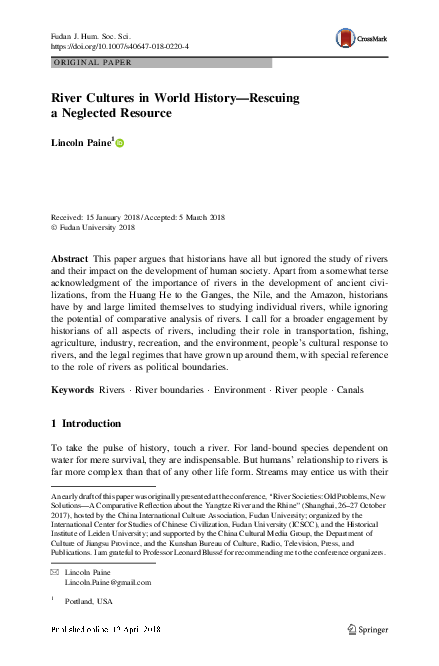
The American geographer John Wesley Powell repeatedly advocated for such an
approach in the nineteenth century, when the US government was busily drawing
straight lines across the map to create states with rectilinear boundaries out of newly
settled territories in the arid region—defined as less than 20 inches (508 mm) of
rainfall annually—west of the 100th parallel. His map entitled Arid Region of the
United States Showing Drainage Districts, drawn to accompany the Eleventh
Annual Report of the Director of the United States Geological Survey, suggests a
rational partition of the land according to watersheds (Powell 1891, plate LXIX).
Had such a scheme been adopted, the USA might have well been spared the fate
Powell had predicted to a hostile audience at the second Irrigation Congress in 1893:
123
�L. Paine
‘‘I tell you, gentlemen, you are piling up a heritage of conflict and litigation over
water rights, for there is not sufficient water to supply the land’’ (in Worster 1985,
132). In fact, the only western state boundary defined even in part by a continental
divide separating two watersheds is between Idaho and Montana (Figs. 1, 2).
An examination of people’s inclination to use or not use rivers as international or
internal borders is long overdue. The subject would seem easily susceptible to
historical analysis because the laying down of political borders is well-documented,
particularly in the western legal tradition, which allows for both comparative and
cross-temporal study. Yet while there is a substantial literature on the legal history of
the delimitation and recognition of boundaries, when and why rivers rather than
continental divides are treated as borders has never received its due. According to the
Treaty of Paris that ended the American Revolution, the boundary drawn between the
USA and Canada followed, in part, ‘‘along the… highlands which divide those rivers
that empty themselves into the river St. Lawrence, from those which fall into the
Atlantic Ocean’’ (in Cukwurah 1967). Other parts of the treaty specify a boundary line
‘‘along the middle’’ of different rivers. Why a watershed in one place but the thalweg
of a river in another? This question becomes even more obvious when asked about the
U.S.-Canada border west of the Great Lakes. The boundary between British North
America and the USA originally followed the divide between the Atlantic and Hudson
Bay watersheds (see Fig. 3), but was straightened after territorial concessions were
made under the Convention of 1818. It is worth asking what the rationale for such a
straight-line delineation was when a watershed boundary would have made little
difference to the overall size of the two countries and would have simplified their
relations over what is now a shared and increasingly valuable resource.
Most countries have viewed control of waterways for either navigation or
irrigation as a vital national interest. In the twenty-first century, access to fresh
water has become a leading source of both legal and violent conflict. Although
conflict over water resources are by no means a modern phenomenon, the term
‘‘water wars’’ has become part of the lexicon of geopolitics only in the past thirty
years as tensions mount between Turkey, Syria, and Iraq; Israel, Syria, Jordan, and
the Palestinian State; Ethiopia, Sudan, and Egypt; Kyrgyszstan, Uzbkekistan, and
Kazakhstan; India and Pakistan; and India and Bangladesh. Understanding the
history of how our forebears put aside their rivalries to share their vital rivers could
help ease tensions in the future, and one way to do this is through an examination of
how political and corporate entities and individuals approached the problem.
Historicizing rivers can take many forms, of which their function as boundaries
and borders is only one. Inasmuch as river history can be viewed as an extension of
maritime history, Frank Broeze’s ‘‘conceptual framework’’ for the study of the sea,
which he ‘‘based on the different uses [people] make both of the sea itself and of
what the sea represents to them,’’ is readily adaptable to river history.
1.
2.
3.
4.
5.
Using the resources of rivers (water, fish, etc.);
using rivers for transport;
using rivers for power projection;
scientific and geographic exploration;
leisure activities; and
123
�River Cultures in World History—Rescuing a Neglected…
Fig. 1 Powell, Arid Region of the US map
6.
the inspiration of rivers in culture and ‘‘ideology’’ (Broeze 46).
To this we could add a seventh point: the natural and anthropogenic environment
of rivers. All of these perspectives fall within the purview of the historian. If I, like
Solomon, could have my wish, it would be that we show more humility before these
strong brown gods, and treat them with the reverence we reserve for our ancestors
and as living entities whose fates are indivisible from our own. Our goal must be a
123
�L. Paine
Fig. 2 Map of Western USA
123
�River Cultures in World History—Rescuing a Neglected…
Fig. 3 Continental Divides of North America. Note how the Laurentian Divide crosses and recrosses the
U.S.-Canada border
deeper and broader commitment to teasing out the entwined history of people and
rivers.
References
American Historical Review Forum. 2006. Oceans of history. American Historical Review 111(3):
717–780.
Blussé, Leonard. 2018. Archipelagoes of towns: Medium-sized cities of the lower Yangzi and Rhine
basins compared, 1350–1850. Fudan Journal of the Humanities and Social Sciences.
Boxer, C.R. 1965. The Dutch seaborne empire, 1600–1800. New York: Penguin.
Broeze, Frank. 1989. From the periphery to the mainstream: The challenge of Australia’s maritime
history. The Great Circle 11(1): 1–13.
Budiyuwono, Hartanto. 2016. House typology of Musi River’s edge in the city of Palembang, south of
Sumatra—Indonesia. Indian Journal of Science and Technology. https://doi.org/10.17485/ijst/2016/
v9i10/74571.
Clark, Hugh R. 2009. Frontier discourse and China’s maritime frontier: China’s frontiers and the
encounter with the sea through early imperial history. Journal of World History 20(1): 1–33.
Coupland, Simon. 2002. Trading places: Quentovic and Dorestad reassessed. Early Medieval Europe
11(3): 209–232.
Cukwurah, A.O. 1967. The settlement of boundary disputes in international law. Manchester: Manchester
University Press.
Eliot, T.S. 1952. Four Quartets. In The complete poems and plays, 1909–1950, ed. T.S. Eliot, 130–145.
New York: Harcourt Brace.
123
�L. Paine
Environmental Protection Agency. 2016. Hudson river PCBs, PCBs and human health. Washington,
D.C.: Environmental Protection Agency. https://www3.epa.gov/hudson/humanhealth.htm. Accessed
21 January 2018.
Forsyth, Luc. 2015. A river and its people in trouble. Phnom Penh Post, 5 December. http://www.
phnompenhpost.com/post-weekend/river-and-its-people-trouble. Accessed 9 October 2017.
Geographical Review. (1999). Special issue—Oceans connect, 89:2.
Kerner, Robert J. 1942. The urge to the sea—The course of Russian history: The role of rivers, portages,
ostrogs, monasteries, and furs. Berkeley: University of California Press.
Kosian, Menne, Henk Weerts, Rowin Van Lanen, and Jaap Evert Abrahamse. 2013. The city and the
river. The early medieval emporium (trade centre) of Dorestad; Integrating physical geography with
archaeological data in changing environments. International Conference on Cultural Heritage and
New Technologies, Vienna, 2012. Amersfoort.
MacLeod, Roy M. 1966. Social policy and the ‘‘floating population’’: The administration of the Canal
Boats Acts, 1877–1899. Past and Present 35: 101–132.
Moore, Marianne. 1959. O to be a dragon: New poems. New York: Viking.
Otis, Daniel. 2014. The vanishing boat people of Phnom Penh. Resilient Cities, 15 April. https://nextcity.
org/daily/entry/the-vanishing-boat-people-of-phnom-penh. Accessed 8 October 2017.
Paine, Lincoln. 1985. The book locker. Sea History 37: 40.
Paine, Lincoln. 2013. The sea and civilization: A maritime history of the world. New York: Alfred A.
Knopf.
Powell, John Wesley. 1891. Eleventh annual report of the United States Geological Survey to the
Secretary of the Interior 1889–’90, Part 2. Washington: Irrigation.
Roy, Eleanor Ainge (2017). New Zealand river granted same legal rights as human being. The Guardian,
16 March. https://www.theguardian.com/world/2017/mar/16/new-zealand-river-granted-same-legalrights-as-human-being. Accessed December 6, 2017.
Shiba, Yoshinobu, and Mark Elvin. 1992. Commerce and society in Sung China. Ann Arbor: University
of Michigan, Center for Chinese Studies.
Stone, Christopher D. 1972. Should trees have standing?—Towards legal rights for natural objects.
Southern California Law Review 45: 450–501.
Twain, Mark. 1883. Life on the Mississippi. New York: Harper and Brothers.
Upadhyay, Vineet. 2017. Ganga & Yamuna are ‘‘living persons’’ with legal rights: high court. The
Economic Times, 21 March. http://economictimes.indiatimes.com/news/politics-and-nation/gangayamuna-are-living-persons-with-legal-rights-high-court/articleshow/57747803.cms. Accessed 10
October 2017.
Wallace, Alfred Russel. 1869. The Malay archipelago, the land of the orang-utan and the bird of
paradise: A narrative of travel with studies of man and nature. Reprint London: Macmillan, 1890.
Worster, Donald. 1985. Rivers of empire: Water, aridity, and the growth of the American West. New
York: Oxford University Press.
Lincoln Paine is a maritime historian, author, editor, and curator whose books include the award-winning
The Sea and Civilization: A Maritime History of the World (2013), Down East: A Maritime History of
Maine (2000; reissued in 2018 as Down East: An Illustrated History of Maritime Maine), and Ships of the
World: An Historical Encyclopedia (1997). He has written and lectured worldwide on a range of maritime
topics, including literature of the sea, exploration, museum curatorship, decorative arts, maritime law,
trade, naval history, and rivers. He has been an editor at Itinerario: International Journal on the History
of European Expansion and Global Interaction and Sea History magazine. He is a trustee of the Maine
Maritime Museum.
123
�
 Lincoln Paine