Remote Sensing of Environment 113 (2009) 755–770
Contents lists available at ScienceDirect
Remote Sensing of Environment
j o u r n a l h o m e p a g e : w w w. e l s ev i e r. c o m / l o c a t e / r s e
A physics based retrieval and quality assessment of bathymetry from suboptimal
hyperspectral data
Vittorio E. Brando a,⁎, Janet M. Anstee a, Magnus Wettle a, Arnold G. Dekker a,
Stuart R. Phinn b, Chris Roelfsema b
a
b
Environmental Remote Sensing Group, CSIRO Land and Water, Canberra, Australia
Center for Remote Sensing and Spatial Information Science, School of Geography, Planning and Architecture, University of Queensland, Brisbane, Australia
a r t i c l e
i n f o
Article history:
Received 11 August 2008
Received in revised form 4 December 2008
Accepted 6 December 2008
Keywords:
Hyperspectral imagery
Bathymetry retrieval
Quality control
Radiative transfer models
a b s t r a c t
In order to retrieve bathymetry, substratum type and the concentrations of the optically active constituents of the
water column, an integrated physics based mapping approach was applied to airborne hyperspectral data of
Moreton Bay, Australia. The remotely sensed data were sub-optimal due to high and mid-level cloud covers.
Critical to the correct interpretation of the resultant coastal bathymetry map was the development of a quality
control procedure based on additional outputs of the integrated physics based mapping approach and the
characteristics of the instrument. These two outputs were: an optical closure term which defines differences
between the image and model based remote sensing signal; and an estimate of the relative contribution of the
substratum signal to the remote sensing signal. This quality control procedure was able to identify those pixels
with a reliable retrieval of depth and to detect thin and thick clouds and their shadows, which were subsequently
masked out from further analysis. The derived coastal bathymetry in depths ranging 4–13 m for the mapped area
was within ±15% of boat-based multi-beam acoustic mapping survey of the same area. The agreement between
the imaging spectrometry and the acoustic datasets varies as a function of the contribution of the bottom visibility
to the remote sensing signal. As expected, there was greater agreement in shallower clear water (±0.67 m) than
quasi-optically deep water (±1.35 m). The quantitative identification and screening of the optically deep waters
and the quasi-optically deep waters led to improved precision in the depth retrieval. These results suggest that the
physics based mapping approach adopted in this study performs well for retrieving water column depths in
coastal waters in water depths ranging 4–13 m for the area and conditions studied, even with sub-optimal
imagery.
Crown Copyright © 2008 Published by Elsevier Inc. All rights reserved.
1. Introduction
The ability to accurately estimate water column depth over large
areas and/or in remote locations is directly relevant to environmental
management, exploration, defence and research applications. The
potential to utilise remote sensing to this end has been discussed for
over 2 decades, but has been mostly limited to empirical approaches
(Clark et al., 1987; Lyzenga, 1981; Philpot, 1989) that are not easily
transferable across study areas or data types (Lee et al., 2001; Stumpf
et al., 2003). Recently, approaches for mapping bathymetry in optically
shallow water bodies have evolved to non-linear optimization of semianalytical models (Adler-Golden et al., 2005; Albert & Gege, 2006; Lee
et al., 1999, 2001) and comparative methods of spectral library matching
(Louchard et al., 2003; Mobley et al., 2005) from hyperspectral data and
modelled data. In some cases these approaches can also be used to
⁎ Corresponding author.
E-mail address: vittorio.brando@csiro.au (V.E. Brando).
produce corrected substratum reflectance spectra and to quantify
concentration of organic and inorganic water constituents.
Lee et al. (1999, 1998) developed a semi-analytical model for
shallow water remote sensing based on the analytical model proposed
by Maritorena et al. (1994). Lee et al. (1999, 2001) used an inversionoptimization approach to simultaneously derive water depth and
water column properties from hyperspectral data in coastal waters.
Adler-Golden et al. (2005) present an algorithm similar to that of Lee
et al. (2001). However, it makes the simplifying assumption of constant water optical properties within the scene. McIntyre et al. (2006)
presented an application of the Lee et al. (2001) inversion modelling
approach to clear waters which included a quantitative comparison of
model-derived depth with high resolution multi-beam acoustic bathymetry data.
Several authors recently extended the method developed by Lee et al.
(1999, 2001) by incorporating linear un-mixing of the benthic cover.
Giardino et al. (2007) used two substrate classes (bare sand and
submerged macrophytes) for the littoral zone of a lake, while Goodman
and Ustin (2007) and Klonowski et al. (2007) integrated a semi-
0034-4257/$ – see front matter. Crown Copyright © 2008 Published by Elsevier Inc. All rights reserved.
doi:10.1016/j.rse.2008.12.003
�756
V.E. Brando et al. / Remote Sensing of Environment 113 (2009) 755–770
analytical inversion model with a linear un-mixing of three substratum
types for coral reef environments.
In this work, an enhanced implementation of the inversion/optimization approach by Lee et al. (1999, 2001) was applied to airborne
hyperspectral data of a shallow water coastal embayment. The approach
was used to estimate bathymetry, substratum composition (i.e. fractional cover of e.g. sand, silt, mud, seagrass and macroalgae) and the
concentrations of the optically active constituents of the water column,
including chlorophyll, coloured dissolved organic matter (CDOM) and
non algal particulate matter (NAP). Fig. 1 presents the schematic flowchart of the integrated physics based mapping approach that includes
atmospheric correction and an objective process of quality control.
To overcome the inadequate quality of portions of the imagery due
the cloud cover in the area, a quality control procedure based on physical
quantities was developed in order to identify those pixels where reliable
retrieval of depth could be performed. The quality control procedure was
based on a measure of optical closure, i.e., the similarity between belowsurface modelled reflectance and that measured in the image, and a
quantitative estimate of the contribution of the substratum signal to the
remote sensing signal.
The comparison of the depth retrieved from the hyperspectral imagery with the depth measured during a boat-based multi-beam acoustic
mapping survey demonstrates the effect of this objective quality control
procedure. The accuracy and precision of the coastal bathymetry
retrieval is discussed as a function of the quantitative estimate of the
contribution of the substratum to the remote sensing signal.
2. Data and methodology
2.1. Study site
The study site is located in Moreton Bay (27°30′S, 153°30′E), a large
embayment located on the east coast of Australia. The Bay is
surrounded by shallow banks to the north and protected by Moreton
and North Stradbroke Islands on the east and southeast sides (Fig. 2).
Moreton Bay can be considered a representative example of the range
of water quality and substratum cover types typically found in coastal
and coral reef environments. (Phinn et al., 2005, 2008).
Moreton Bay substratum contains significant areas of unconsolidated sediments, ranging from fine-silt muds in the western bay to
silicate sands in the eastern bay. Extensive seagrass beds and macroalgae occur throughout the bay, as do bedrock outcrops and fringing
reefs. Due to the number of creeks and rivers that drain into the
western part of the Bay and the oceanic openings on its eastern side,
the water column usually ranges from freshwater influenced, and
often turbid in the western bay, to oceanic water dominated and clear
blue-green waters of the eastern bay (Phinn et al., 2005, 2008).
2.2. Image acquisition and processing
2.2.1. CASI-2 airborne hyperspectral Images
Airborne hyperspectral imagery was acquired on 28 July 2004 over
the Eastern Banks area in Moreton Bay (Fig. 2A) with a CASI-2
(Compact Airborne Spectrographic Imager) measuring upwelling
radiance [µWcm− 2sr− 1nm− 1]. The hyperspectral dataset was collected
as part of a larger project which evaluated the accuracy of various
image types and image processing approaches for mapping coastal
ecosystem health indicators (Phinn et al., 2005, 2008).
Flight-lines were flown within 1 h of low tide, with a pixel size of
4 × 4 m and a swath of ∼2.0 km. The flight-line plan minimized sun
glint and hotspots by flying in and out of the solar plane (Dekker et al.,
2001). The CASI-2 band-set was programmed to have 30 nearcontiguous spectral bands in the visible-near infrared region (441–
847 nm). The band selection of the CASI was designed to optimize the
signal-to-noise ratio (SNR) across the spectrum by using variable
bandwidths. The bands in the blue and near infrared region, where the
sensor has a lower sensitivity, have a bandwidth of ∼20 nm, while the
bands in the 500–680 nm range have a ∼ 10 nm bandwidth (Fig. 3).
Due to the nature of the spectral band configuration, the full width at
half maximum (FWHM) is equivalent to the bandwidth as it results
from a combination of narrow channels with 1.3 nm FWHM.
Fig. 1. Concept and schematic flow chart of the integrated physics based mapping approach
for estimating bathymetry, substratum composition (i.e. fractional cover of e.g. sand, silt,
mud, seagrass, macroalgae) and the concentrations of the optically active constituents of
the water column (CCHL, CCDOM, CNAP). All symbols are defined in Table 1.
2.2.2. Atmospheric and air water interface correction
As the first step of the integrated physics based mapping approach
(Fig. 1), the ‘coastal Waters and Ocean MODTRAN-4 Based ATmospheric
correction’ (‘c-WOMBAT-c’) procedure (Brando & Dekker, 2003; Phinn
et al., 2005) was applied to achieve hyperspectral atmospheric correction
of the CASI-2 imagery. The procedure combines an atmospheric
inversion from at-sensor-radiance to above water reflectance (AdlerGolden et al., 1998; De Haan et al., 1997) with an inversion of the air–
water interface from above water reflectance to subsurface reflectance
(De Haan & Kokke, 1996; De Haan et al., 1997).
c-WOMBAT-c applies a full MODTRAN-4 atmosphere parameterization and characterisation to retrieve the subsurface remote-sensing
reflectance (rrs, [sr− 1]) from the CASI-2 at-sensor-radiance. The atmospheric parameterization for each flight-line was based on radiosonde
data from the Australian Bureau of Meteorology Station at Brisbane
�V.E. Brando et al. / Remote Sensing of Environment 113 (2009) 755–770
International Airport to estimate the atmospheric column water
contents, the actual and the 24 h average wind speed. The estimate of
ozone content was downloaded for the dates of CASI overflights from the
Total Ozone Mapping Spectrometer—TOMS database (http://toms.gsfc.
nasa.gov/ozone/ozone.html). The MODTRAN-4 summer mid-latitude
atmosphere with navy maritime aerosol model and a horizontal visibility
757
of 50 km was used, as this most closely matched the conditions at the
time the image was taken.
In c-WOMBAT-c, adjacency effects from photons transferring from
adjacent pixels to the one being sampled are corrected for by using an
averaged surface radiance for the surrounding region. This spatially
weighted image is generated by convolving the input radiance imagery
Fig. 2. Study area. A) Pseudo true colour composite of the CASI-2 imagery for the western portion of the Eastern Banks. The map is presented with the outlines of the bathymetric
surveys. B) Pseudo true colour composite of the CASI-2 imagery for the Rous Channel area with the extent of the acoustic bathymetric survey overlaid as the orange thick polygon. The
image is presented with the bathymetry vectors supplied by the Queensland Department of Transport.
�758
V.E. Brando et al. / Remote Sensing of Environment 113 (2009) 755–770
Fig. 2 (continued).
with a 1 km2 spatial weighting function (Adler-Golden et al., 1998). The
code is available from the authors upon request.
2.2.3. Illumination and geometric correction and cloud masking
After atmospheric correction, a residual brightness variation across
each track-line could still be observed in several flight-lines. Cross track
illumination variation is due to several physical environmental and
sensor effects such as varying atmospheric path length, Fresnel
reflection of diffuse skylight, camera lens and diaphragm effects,
vignetting effects, instrument scanning, CCD illumination effects,
internal scattering in the sensor and other non-uniform illumination
effects. A cross-track correction for illumination variation was applied to
remove these distortions. For each flight-line, a Row and Column
Analysis of Variance (RC-ANOVA) was computed to correct for the
systematic across-track illumination variation. The means and variances
of the columns were used to balance each image band to the scene
statistics (Brando & Dekker, 2003; Datt et al., 2003). In a scene that
covers land, shallow water and deep water targets, scene statistics that
are calculated over the entire image would not be representative for the
deeper water targets. Therefore, an “as homogeneous as possible” water
area of 50–100 lines was used as input for the statistics of each flightline. For each spectral band, a 3rd order polynomial was fitted to the
average value of each column after which an additive column-bycolumn RC-ANOVA correction was performed on the imagery.
The CASI-2 data were geometrically corrected and geo-referenced by
the data provider, using data from the aircraft's inertial measurement
unit and an onboard GPS unit referenced to a GPS base station. Following
this, a manual adjustment and matching of each flight line to Landsat 5
Thematic Mapper image collected in August 2004 was performed to
minimize the residual error in geo-location (Phinn et al., 2006, 2008).
A preliminary masking of the clouds based on their spectral
properties was attempted but it was not adopted as it showed a low
accuracy: very shallow portions of the Eastern Banks are very bright
with reflectance properties similar to those of clouds in most spectral
bands (see Fig. 2B). Thin and thick cloud masking was performed later
as part of the quality control process of the integrated physics based
mapping approach (see Sections 2.4.6 and 3.1).
2.2.4. Environmental dynamic range
In order to understand the precision and accuracy that can be
achieved in the estimate of an environmental variable derived from
reflectance with hyperspectral imagery, it is necessary to estimate the
overall sensitivity of the entire sensor–atmosphere–air–water interface system for detecting changes in reflectance. The environmental
Fig. 3. CASI-2 programmable band set: spectral sensitivity (left axis) and noise equivalent difference in reflectance NEDrrsE (right axis).
�759
V.E. Brando et al. / Remote Sensing of Environment 113 (2009) 755–770
Fig. 4. Bathymetric surface derived from the acoustic bathymetric survey for the Rous Channel area. The bathymetry map is presented with the bathymetry vectors supplied by the
Queensland Department of Transport.
noise equivalent reflectance difference (NEΔrrsE) provides an integrated measure of sensor signal-to-noise ratio and scene-specific
characteristics (Brando & Dekker, 2003; Wettle et al., 2004). For
aquatic remote sensing, examples of the latter include atmospheric
variability, effects from the air–water interface such as swell, wave
and wavelet induced reflections, and refractions of diffuse and direct
sunlight (Brando & Dekker, 2003).
The second step of the integrated physics based mapping approach
(Fig. 1) is to estimate NEΔrrsE in the deepest waters in the CASI-2 mosaic
in the location identified as being the most homogenous using the
methodology described by Wettle et al., (2004). Fig. 3 shows that NEΔrrsE
is lower than 0.00025 [sr− 1] in the 500–800 nm spectral range, with the
exception of the very narrow band centred at 760 nm. As distinguishable
levels of 0.00025 [sr− 1] are desirable (Brando & Dekker, 2003; Dekker
et al., 2001), the quality of this imagery was deemed appropriate for
further analysis.
2.3. Acoustic bathymetry data
As part of the larger project which evaluated the accuracy of various
forms or image types and image processing approaches for mapping
coastal ecosystem health indicators (Phinn et al., 2005, 2008), a number
of underwater acoustical and video sensors were deployed in Moreton
Bay between 29 August and 5 September 2004 (Siwabessy et al., 2006).
The field equipment used in the survey included a RESON8125 multibeam, a SIMRAD EQ60 single beam and Klein 5500 sidescan sonar
systems, as well as an underwater video system (Siwabessy, 2005). The
objective was to establish the domains, in terms of depths and water
clarity, under which each data-set does and does not function effectively.
For the bathymetric survey, the RESON 8125 multi-beam survey
lines were run parallel to the contour in order to get the maximum
swath coverage in a short time. Accurate navigation and correction for
motion allowed for stitching of overlapping swath lines and suppression of motion artefacts (Siwabessy, 2005). Raw bathymetry data were
corrected for roll, pitch, yaw and GPS latency, as well as for the tide
and the refraction. The corrected bathymetry was edited by removing
bad data points/spikes. The bathymetry data were normalized to the
Australian Height Datum and then re-sampled to the pixel size of the
CASI imagery.
The uncertainty in the depth soundings was likely to be no more
than a few centimetres, as the errors relate to the tidal model used to
process the data, the motion sensor errors and the positional accuracy.
These effects were corrected for whilst processing the bathymetry
(Siwabessy, 2005).
Although approximately 82% of the Eastern Banks area is 3.0 m or
shallower in depth (Phinn et al., 2005, 2008), the acoustic bathymetric
survey for the Rous Channel area was carried out in a channel 5–10 m
deep with a sandy substratum. Fig. 4 presents the bathymetric surface
derived from the acoustic bathymetric survey for the Rous Channel
area. The bathymetric surface corresponds to and accurately aligns
with the rather coarse bathymetry vectors (1, 2, 3, 5, 10 and 20 m
isobaths) which were based on a compilation of older data and were
supplied by the Queensland Department of Transport. The acoustic
Table 1
Symbols and definitions
Symbol
Description
CDOM
NAP
CCHL
CCDOM
CNAP
a
aw
aphy
aCDOM
aNAP
bb
bbw
bbp
bbphy
bbNAP
⁎ (λ)
aphy
SCDOM
⁎ (λ0)
aNAP
SNAP
λ0
⁎ (λ0)
bbphy
Coloured dissolved organic matter
Non algal particles
Concentration of chlorophyll-a
Measure of coloured dissolved organic matter
Concentration of non algal particles
Total absorption coefficient, aw + aphy + aCDOM + aNAP
Absorption coefficient of pure seawater
Absorption coefficient of phytoplankton pigments
Absorption coefficient of CDOM
Absorption coefficient of NAP
Total backscattering coefficient, bbw + bbp
Backscattering coefficient of pure seawater
Backscattering coefficient of suspended particles, bbphy + bbNAP
Backscattering coefficient of phytoplankton particles
Backscattering coefficient of NAP
Chlorophyll-a specific absorption spectrum
Spectral slope constant for CDOM absorption coefficient
Specific absorption of NAP at the reference wavelength
Spectral slope constant for NAP absorption coefficient
Reference wavelength
Specific backscattering of algal particles at the reference
wavelength
Power law exponent for the algal particles backscattering
coefficient
Specific backscattering of NAP at the reference wavelength
Power law exponent for NAP backscattering coefficient
Subsurface remote-sensing reflectance for an optical shallow
water body
Subsurface remote-sensing reflectance over a hypothetical
optically deep water column
Measured subsurface remote-sensing reflectance
Modelled subsurface remote-sensing reflectance
Optically deep component of rmodel
rs
Noise equivalent difference in reflectance
Substratum albedo (irradiance reflectance)
Vertical attenuation coefficient for diffuse downwelling light
Vertical attenuation coefficient for diffuse upwelling light
originating from the bottom
Vertical attenuation coefficient for diffuse upwelling light
originating from each layer in the water column.
Optimization residuum
Spectral substratum detectability
Substratum detectability index
Yphy
b⁎bNAP (λ0)
YNAP
rrs
dp
rrs
input
rrs
model
rrs
dp_model
rrs
NEΔrrsE
A
Kd
κB
κC
Δ
SD
SDI
Units
µg∙L− 1
m− 1
Mg L− 1
m− 1
m− 1
m− 1
m− 1
m− 1
m− 1
m− 1
m− 1
m− 1
m2mg− 1
nm− 1
m2g− 1
nm− 1
nm
m2mg− 1
–
m2g− 1
–
sr− 1
sr− 1
sr− 1
sr− 1
sr− 1
sr− 1
–
m− 1
m− 1
m− 1
–
sr− 1
–
�760
V.E. Brando et al. / Remote Sensing of Environment 113 (2009) 755–770
bathymetric survey (Fig. 4) will be used for validation of the bathymetry retrieved with the integrated physics based mapping approach
applied in this study to the hyperspectral imagery.
2.4. Retrieval of bathymetry, substratum composition and the optically
active constituents
The third and pivotal step of the integrated physics based mapping
approach (Fig. 1) is a physics based retrieval of bathymetry, substratum
composition (i.e. fractional cover of e.g. sand, silt, mud, seagrass and
macroalgae) and the concentrations of the optically active constituents
of the water column (chlorophyll, CDOM and NAP) from the rrs imagery.
To this aim, the inversion/optimization method by Lee et al. (1999, 2001,
1998) was enhanced in order to: 1) retrieve the concentrations of
optically active constituents in the water column (chlorophyll-a, CDOM
and NAP), 2) account for more than one substratum cover type and 3) to
estimate the contribution of the substratum to the remote sensing
signal. This implementation, called SAMBUCA (the semi-analytical
model for bathymetry, un-mixing, and concentration assessment), is
available from the authors upon request.
2.4.1. Principles of the physics based method
At the core of the inversion/optimization method by Lee et al. (1999,
2001, 1998) lies an analytical expression for rrs for an optical shallow
water body (Maritorena et al., 1994):
h
i
rrs = rrsdp + expð−Kd H Þ A expð−κ B H Þ−rrsdp expð−κ C HÞ
ð1Þ
r dp
rs
is subsurface remote-sensing reflectance over a hypothetical
where,
optically deep water column; H is the water depth; A, the bottom albedo
(substratum reflectance); Kd, the vertical attenuation coefficient for
diffuse downwelling light, κB, the vertical attenuation coefficient for
diffuse upwelling light originating from the bottom; and κC, the vertical
attenuation coefficient for diffuse upwelling light originating from each
layer in the water column (Table 1). Note that the attenuation of the
upward flux is not equivalent to the attenuation of the downward flux
(Kd). Attenuation of the upward flux must further be separated into a
component originating from the water column (κC) and that originating
from the bottom (κB) (Maritorena et al., 1994). By relating the four
d
quantities r dp
rs , K , κB and κC to absorption and backscattering via a series
of semi-analytical relationships, Lee et al. (1999, 2001, 1998) modelled
the rrs spectrum as a function of five independent variables (representing properties of water column and bottom):
rrs = f ðP;G;X;B;HÞ
ð2Þ
where P, G, X, and B are scalar values and represent absorption
coefficients of phytoplankton and gelbstoff (coloured dissolved organic
matter plus detritus), backscattering coefficient of suspended particles,
and bottom reflectance at a reference wavelength, respectively; and H is
the bottom depth.
2.4.2. Semi analytical model for bathymetry unmixing and concentration
assessment (SAMBUCA)
In the inversion-optimization scheme in SAMBUCA the modelled
subsurface remote-sensing reflectance (rmodel
) is compared to the
rs
measured subsurface remote-sensing reflectance (rinput
) which was
rs
obtained from each pixel in the remote sensing image. The set of
variables that minimizes the difference between these two spectra is
used to estimate the environmental variables being sought, e.g. water
column depth, substratum composition or the concentrations of the
optically active constituents of the water column.
The extraction of environmental information from measured reflectance spectra constitutes a radiative transfer inverse problem. Inverse
problems are notoriously difficult because of potential non-uniqueness
issues (Mobley et al., 2005). It is often necessary to constrain inverse
problems so as to guide the inversion to the correct solution. Such
constraints often take the form of simplifying assumptions about the
underlying physical or mathematical problem, or of added environmental information. For the inversion-optimization in SAMBUCA, the
Downhill Simplex method was adopted, whilst ranges for variables to be
optimized were constrained to reduce the occurrence of spectral
ambiguities (Wettle et al., 2005; Wettle & Brando, 2006).
In SAMBUCA, the algorithm by Lee et al. (1999, 2001, 1998) was
modified to retrieve the concentrations of optically active constituents in
the water column (chlorophyll-a, CDOM and NAP). The absorption and
backscattering coefficients are described as the sum of the contributions
of N constituents and a constant coefficient for pure water:
N
N
j=1
j=1
a = aw + ∑ aTj Cj ; bb = bbw + ∑ bTbj Cj
ð3Þ
where aw and bbw are the absorption and backscattering of pure water
(Morel, 1974; Pope & Fry, 1997), a⁎j .and bbj⁎ are the specific inherent
optical properties (SIOPs) of jth constituent with concentration Cj. In
the formulation of Eq. (3), CDOM has no backscattering term
associated with it, and aCDOM (440 nm) represents the concentration
of CDOM.
The non-water absorption terms are parameterized as a known
shape with an unknown magnitude:
aphy ðλÞ = CCHL d aTphy ðλÞ
ð4Þ
aCDOM ðλÞ = CCDOM d aTCDOM ðλ0 Þexp½−SCDOM ðλ−λ0 Þ
ð5Þ
aNAP ðλÞ = CNAP d aTNAP ðλ0 Þexp½−SNAP ðλ−λ0 Þ
ð6Þ
where CCHL is the concentration of chlorophyll-a and aphy⁎(λ) is the
chlorophyll-a specific absorption spectrum. As the concentration of
CDOM (CCDOM) is represented by aCDOM (440 nm), the reference
wavelength λ0 was set at 440 nm, SCDOM is the spectral decay constant
⁎
for CDOM absorption coefficient and aCDOM
(λ0) is set to 1. CNAP is the
⁎
concentration of NAP; aCDOM (λ0) is the specific absorption of NAP at
the reference wavelength, and SNAP is the spectral slope constant for
NAP absorption coefficient; and the reference wavelength λ0 was set
at 440 nm for NAP absorption coefficient.
The non-water backscattering terms are parameterized as follows:
bbp = bbphy + bbNAP
� �Yphy
λ0
bbphy ðλÞ = CCHL d bTbphy ðλ0 Þ
λ
� �YNAP
λ0
bbNAP ðλÞ = CNAP d bTbNAP ðλ0 Þ
λ
ð7Þ
ð8Þ
ð9Þ
⁎ (λ0) is the specific backscattering of algal particles at the
where bbphy
reference wavelength, Yphy, the power law exponent for the algal
⁎ (λ0) is the specific backscattering of NAP at
particles coefficient; bbNAP
the reference wavelength, and YNAP, the power law exponent for NAP
backscattering coefficient. The reference wavelength λ0 was set at
542 nm for both algal and non algal particle backscattering coefficient.
In SAMBUCA, the algorithm by Lee et al. (1999, 2001, 1998) was
modified to account for more than one substratum cover type in a
pixel or spectrum by expressing the bottom albedo A(λ) as a linear
combination of two substrata:
�
�
AðλÞ = qij Ai ðλÞ + 1−qij AðλÞ
ð10Þ
where qij represents the fractional cover of substratum i and
substratum j within each pixel, Ai(λ) and Aj(λ) are the albedos of
substratum i and j, respectively. When solving for more than two
�761
V.E. Brando et al. / Remote Sensing of Environment 113 (2009) 755–770
cover types, SAMBUCA cycles through a given spectral library,
retaining those two substrata and their estimated fractional cover qij
which achieve the best spectral fit.
In summary, the complete model parameterization of Eq. (1) for
SAMBUCA is:
model
rrs
=f
�
�
CCHL ;CCDOM ;CNAP ;H;qij ;Ai ðλÞ;Aj ðλÞ;SCDOM ;SNAP ;
:
YPHY ;YNAP ;aTPHY ðλÞ;aTNAP ðλ0 Þ;bTbPHY ðλ0 Þ;bTbNAP ðλ0 Þ
ð11Þ
2.4.3. The parameterization of SAMBUCA
The parameterization of the semi-analytical model (Eq.(11)) relies
on field sampling of the optical properties of the water body of
interest. When this is not possible, the semi-analytical model (Eq. (11))
can be parameterized with appropriate values from the literature. For
this study, inherent and apparent optical properties of Moreton Bay
waters in winter were measured as part of a fieldwork campaign
undertaken to coincide with image acquisition and other field surveys
from 27th of July to the 3rd of August 2004. In-situ absorption,
attenuation, backscattering, reflectance and vertical attenuation were
measured at 20 locations in the bay (Phinn et al., 2006), and water
samples were collected for measuring in vivo absorption of CDOM,
chlorophyll and NAP, as well as the NAP and chlorophyll concentrations. All these measurements were carried out with the same instruments and laboratory methods described in Oubelkheir et al.,
(2006) and Phinn et al., (2006). Reflectance spectra of substratum,
benthic algal species and epiphytic algal and invertebrate species were
measured as in Roelfsema et al. (2006).
Based on these field data, SAMBUCA was configured to estimate
the concentrations of optically active constituents in the water column
(chlorophyll-a, CDOM and NAP), water column depth, and benthic
substratum composition that produces the best fit between modelled
and measured rrs. These five environmental parameters are solved for
on a pixel-by-pixel basis.
Table 2 reports the allowed optimization ranges for the chlorophyll, CDOM, and NAP concentrations, and the fixed values for
seven scalar parameters (SCDOM, SNAP, a⁎NAP (440 nm), b⁎
bphy (542 nm),
b⁎bNAP (542 nm), Yphy and YNAP) while the chlorophyll-a specific
⁎ (λ) is presented in Fig. 5A. The values of
absorption spectrum aphy
the SIOP parameters for this study (Table 2, Fig. 5A) are similar to those
reported previously for Moreton Bay and other Australian coastal
waters (Brando & Dekker, 2003; Oubelkheir et al., 2006; Qin et al.,
2007). Yphy and YNAP have the same value as they were estimated from
the in situ particulate backscattering measured using a HydroScat-6
according to Oubelkheir et al. (2006).
In the area of interest of this study, where the acoustic survey data
were available for validation (namely Rous Channel, Fig. 2B), only two
bare substrata were identified: brown mud and bright sand (Phinn
et al., 2006; Phinn et al., 2008; Siwabessy, 2005). Hence, as the focus of
this work was to estimate bathymetry from hyperspectral imagery,
SAMBUCA was run with only two substrata (Fig. 5B) to expedite the
inversion.
2.4.4. Measuring the “optical closure”, or goodness-of-fit, between the
modelled and actual image reflectance values
In the inversion-optimization scheme in SAMBUCA, rmodel
is comrs
pared to rinput
using a goodness-of-fit or, error function. The set of
rs
variables that minimizes the difference between these two spectra is
used to estimate the environmental variables being sought, e.g. water
column depth, substratum composition or the concentrations of the
optically active constituents of the water column.
The optimization residuum, Δ, is the measure of the difference between the measured and modelled spectra. In SAMBUCA Δ, can be
estimated according to either a spectral magnitude matching function
(e.g. Least squares in Albert & Gege, 2006; Lee et al., 1999, 2001; Mobley
et al., 2005) or spectral shape matching function (e.g. Spectral Angle
Mapper in Kruse et al., 1993) or as a hybrid formulation that combines
Table 2
SAMBUCA parameterization and optimization ranges
Parameter
Fixed value
Optimization range
0.7 (0.4–1.0)
0.08 (0.04–0.11)
2.8 (1.0–3.3)
CCHL
CCDOM
CNAP
SCDOM
SNAP
a⁎NAP (440 nm)
a⁎bphy (542 nm)
Yphy
b⁎bNAP (542 nm)
YNAP
0.0157
0.0106
0.0048
0.00038
0.681
0.0054
0.681
the spectral matching and the least squares minimum to balance the
requirements for spectral shape and magnitude matching:
Δ = α T LSQ
ð12Þ
where, α[sr− 1] is the spectral angle between reference spectra and the
spectra of the pixel in question as defined in the Spectral Angle
Mapper (SAM, Kruse et al., 1993) by:
α = cos−1 �
�
�
N
input
model
ðλi ÞTrrs
ðλi Þ
∑ wðλiÞT rrs
i=1
N
∑
i=1
�
�
model 2
wðλiÞTrrs
1=2 � N
∑
i=1
�
�2
1=2
ð13Þ
input
wðλi ÞTrrs
ðλi Þ
and LSQ is the Least Square Distance:
LSQ =
�
h
i2
N
input
model
ðλi Þ−rrs
ðλi Þ
∑ wðλi ÞT rrs
i=1
N
1=2
:
ð14Þ
input
ðλi Þ
∑ wðλi ÞTrrs
i=1
The weighting function, w(λ), can be introduced for both LSQ and
α to weigh the contribution of different wavelength bands.
One of the primary advantages of α is that spectral angle is
insensitive to differences in albedo, i.e. the magnitude of the measured
and modelled spectrum. The spectral angle only measures differences
in spectral shape, and spectral magnitude is measured by the length of
each vector (Dennison et al., 2004; Kruse et al., 1993). Since the
residual error is partially dependent on the reflectance of each band
within the modelled spectrum, LSQ will be partially dependent on the
magnitude of the modelled reflectance. As the magnitude of the
modelled spectrum increases, LSQ will also increase (Dennison et al.,
2004).
To assess the spectral match for the inversion, the hybrid
formulation (Eq.(12)) for Δ was adopted, as it combines the strengths
of spectral angle mapping with the strengths of a minimum distance
classifier, ensuring that the resultant spectrum rmodel
has the
rs
appropriate magnitude and shape as the input spectrum rinput
. In
rs
this study, w(λ) was set to 1/NEΔrrsE to discount the wavelengths
where the signal is less accurate or noisier.
As a result of SAMBUCA's inversion-optimization scheme, Δ can be
used as a measure of the goodness-of-fit, between the measured and
modelled spectra (i.e. the optical closure). In other words, each set of
retrieved environmental variables is assigned a confidence rating
based on SAMBUCA's ability to model a given subsurface reflectance
spectra.
2.4.5. Contribution of the substratum to the remote sensing signal–
substratum detectability index
In SAMBUCA, the algorithm by Lee et al. (1999, 2001, 1998) has been
modified to estimate the contribution of the substratum to the subsurface remote-sensing reflectance signal by comparing the modelled
�762
V.E. Brando et al. / Remote Sensing of Environment 113 (2009) 755–770
⁎ (λ). B) SAMBUCA's Spectral library of benthic substrata.
Fig. 5. Spectral parameterization for SAMBUCA. A) Chlorophyll-a specific absorption spectrum aphy
dp_model
spectrum using an optically deep system (rrs
, i.e. the term indicated
dp
as rrs in Eq. (1)), and the modelled spectrum for an optical shallow water
model
body as generated by SAMBUCA (rrs
). Fig. 6 provides a graphical
illustration of the contribution of the substratum to the remote sensing
dp_model
signal for two pixels extracted from the imagery by comparing rrs
model
and rrs
. Fig. 6A presents an example of optically shallow waters where
the signal from the substratum is directly measurable, while Fig. 6B
presents an example where the signal from the substratum is small and
diffuse and close to the noise levels in the imagery.
To provide a quantitative indication of the contribution of the
substratum to the subsurface remote-sensing reflectance signal of the
water body, we introduce SD(λ), the spectral substratum detectability:
�
model
dp
SDðλÞ = rrs
−rrs
model
�
ð15Þ
=NEΔrrsE :
This quantity is sensor dependent and scene dependent: it
quantifies the contribution of the substratum to the subsurface
remote-sensing reflectance signal for a given sensor as it uses the
noise equivalent difference in reflectance (NEΔrrsE) as a scaling factor.
As can be shown by rearranging Eq. (1):
�
h
dp
SD = expð−Kd H Þ A expð−κ B H Þ−rrs
model
i�
expð−κ C HÞ =NEΔrrsE :
ð16Þ
The SD(λ) is function of the vertical attenuation coefficients (Kd,Kg
and Kc), noise equivalents.
Furthermore, we introduce the substratum detectability index
(SDI) defined as the absolute value of the spectral substratum
detectability for the band of maximum penetration:
�
model dp
SDI = max jrrs
−rrs
model
j=NEΔrrsE
�
ð17Þ
Fig. 6(C, D) illustrates the derivation of the spectral substratum
detectability (SD(λ)) and the substratum detectability index (SDI) from the
model
two modelled spectra resulting from the inversion optimization (rrs
dp_model
and rrs
in Fig. 6(A, B)). For the optically shallow water pixel (Fig. 6C)
model
the signal from the substratum |rrs
−r dp_model
| is larger than 0.0005 in
rs
the 500–600 nm spectral range, and SD(λ) is higher than 5 in the same
range, with a maximum of 15 at ∼580 nm (i.e. SDI=15). In Fig. 6D, the
model
signal from the substratum is small and diffuse and |rrs
−r dp_model
| is
rs
larger than 0.0005 only at 500 nm, SD(λ) is therefore equal to 1 or 2 in the
480–580 spectral range, with a maximum of 2 at ∼500 nm (i.e. SDI=2).SDI
allows three classes of waters to be identified in the imagery:
• “optically shallow waters” where the signal from the substratum is
directly measurable and the substratum signal at the surface is more
than 5 NEΔrrsE at the band of maximum penetration (SDI N ∼ 5, e.g.
Fig. 6(A, C));
• “quasi-optically deep waters”, where the contribution from the
substratum is weak and the substratum signal at the surface is
between 1 and 5 NEΔrrsE (i.e. 1 b SDIb 5, e.g. Fig. 6(B, D)); and
�V.E. Brando et al. / Remote Sensing of Environment 113 (2009) 755–770
Fig. 6. Graphical representation of SAMBUCA's main spectral quantities for two pixels extracted from the imagery. rinput
is the measured remote-sensing irradiance reflectance; rmodel
is the modelled subsurface remote-sensing reflectance
rs
rs
resulting from the inversion optimization of rinput
; rdp_model
is the optically deep component of rmodel
; SD is spectral substratum detectability. a and c present an example of “optically shallow waters” where the signal from the substratum is
rs
rs
rs
directly measurable (H = 6.9 m, SDI = 15); while b and d present an example of “quasi optically deep waters” where the signal from the substratum is small and diffuse (H = 10.7 m, SDI = 2).
763
�764
V.E. Brando et al. / Remote Sensing of Environment 113 (2009) 755–770
• “optically deep waters”, where no signal from the substratum is
measurable (i.e. SDI = 0).
For optically deep waters (i.e. SDI= 0) the estimate of depth is not
possible as no signal from the substratum is measurable. Because of that,
the retrieved values of the water depth from the inversion/optimization
can be any of the values deeper than the depth that sets SDI to 0, leading
to an over-estimate of the real depth for those pixels. To retrieve an “as
shallow as possible” depth when an optically deep solution is encountered at the end of a SAMBUCA inversion optimization, a secondary
iteration was introduced. The retrieved depth for the optically deep
pixels is iteratively decreased while maintaining SDI = 0. This secondary
iteration ensures the retrieval of an “as shallow as possible” depth value
for each pixel.
It is worth mentioning that both SD(λ) and SDI are sensor- and
scene-dependent and they could be used to compare the contribution
of the substratum to the remote sensing signal for different sensors or
imagery acquired in different environmental conditions.
2.4.6. Integrating optical closure and SDI to exclude inappropriate data
The fourth step of the integrated physics based mapping approach
(Fig. 1) is an objective process of quality control of the raw SAMBUCA
output. This is based on the combined analysis of two ancillary variables
of the SAMBUCA output, the measure of optical closure (i.e. the
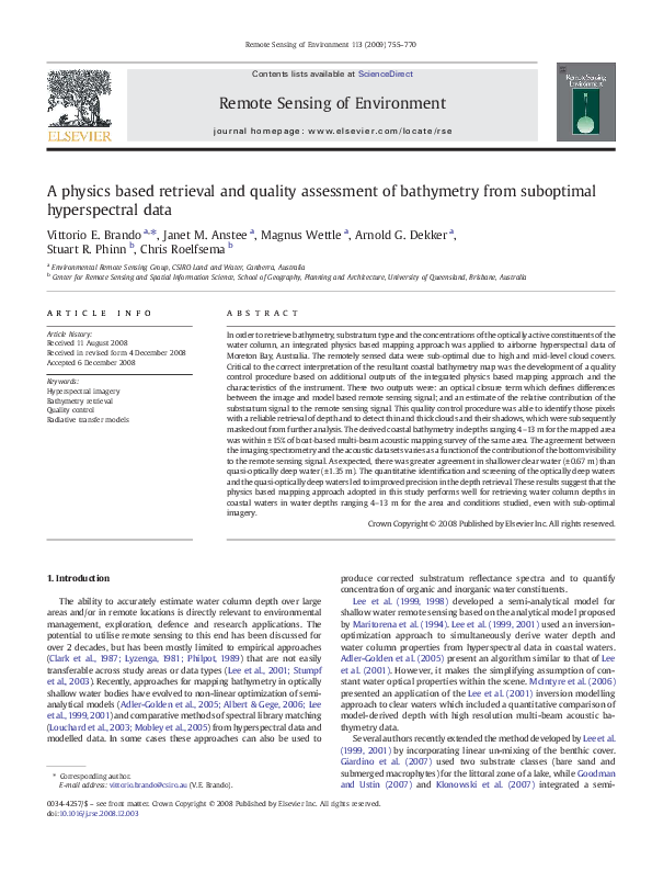
Fig. 7. Process of quality control of the SAMBUCA depth retrieval from CASI-2 image for the Rous Channel area. A) Map of the optimization residuum (D, lower values indicate a good fit).
B) Map of substratum detectability index (higher values indicate a higher signal from the substratum). C) Guide to the interpretation of the SAMBUCA inversion of CASI-2 image for the Rous
Channel area. The maps are overlaid with the extent of the acoustic bathymetric survey and the bathymetry vectors supplied by the Queensland Department of Transport.
�V.E. Brando et al. / Remote Sensing of Environment 113 (2009) 755–770
Table 3
Process of quality control of the SAMBUCA depth retrieval from CASI-2 image for the
Rous Channel area
Poor optical closure
(i.e. Δ N 0.002)
Optically deep
Pixels occurring in few small
(i.e. with SDI = 0) patches in the northern portion
of the imagery (they could be
cloud shadows)
Optically shallow
Pixels occurring in
(i.e. with SDI N 1) correspondence with the thick
clouds in the eastern portion of
the imagery
Good optical closure
(i.e. Δ b 0.002)
Pixels occurring at the kneebend in sonar coverage and
around the patch of pixels with
a poor closure and optically
deep in the western portion of
the imagery
Pixels corresponding to the
overlap of the pixels mapped
out in brighter tones in Fig. 7A
and B
Combination of the optimization residuum and the substratum detectability index (SDI).
optimization residuum, Δ) and the map of substratum detectability
index (SDI). By defining a threshold of the optimization residuum,
Δthresh, it is possible to identify the pixels with a good or poor spectral
match for the inversion, while the substratum detectability index (SDI)
indicates whether the pixels are optically deep or optically shallow. The
combined use of these additional outputs enables the identification of
four classes of pixels:
• pixels with a poor optical closure (i.e. Δ N Δthresh) and optically
shallow or quasi-optically deep (i.e. with SDI N 1);
• pixels with a poor closure and optically deep bi.e. with SDI = 0);
• pixels with a good closure (i.e. Δ b Δthresh) and optically deep;
• pixels with a good closure and optically shallow or quasi-optically
deep.
Only the pixels belonging to the last class should be used for further
analysis of the bathymetry retrieval, since the good optical closure
ensures that a good spectral match for the inversion was attained, while
SDIN 1 ensures that the estimate of depth is possible as the signal from
the substratum is measurable. This systematic quality control procedure
facilitates the use of sub-optimal remote sensing imagery as it assesses
objectively the data quality on a pixel-by-pixel basis.
3. Results and discussion
SAMBUCA was applied to the CASI-2 imagery for the Rous Channel
for the retrieval of depth, concentrations of optically active constituents
in the water column (chlorophyll-a, CDOM and NAP) and substratum
composition. To demonstrate the effect of the physics based quality
control procedure (Fig. 7 and Table 3), the bathymetry output will be
shown before and after the procedure (Figs. 8 and 10) followed by the
765
comparison of the retrieved depth with the acoustic depth (Figs. 9
and 11). The maps of concentrations of chlorophyll, CDOM and NAP and
the substratum composition as retrieved by SAMBUCA will be not
shown or discussed in this paper for the sake of brevity. The retrieved
ranges of CCHL, CCDOM, and CNAP were respectively 0.4–1.0 μg L− 1, 0.04–
0.11 m− 1 and 1.0–3.3 mg L− 1. The retrieved substratum albedo A(550 nm)
ranged between 8 and 40%.
Fig. 8 presents the bathymetric surface derived from CASI-2 image
for the Rous Channel area. This map is the raw SAMBUCA output as it
presents the estimated bathymetry for all the pixels in the imagery
before quality control. Overall, this bathymetric surface is accurately
aligned with the bathymetry vectors supplied by the Queensland
Department of Transport which were overlaid on all the maps for all of
the isobaths. Furthermore, a visual comparison of the bathymetric
surface derived from the CASI-2 image and the bathymetric surface
derived from the acoustic bathymetric survey (Figs. 8 and 4 respectively)
show a generally good agreement. The effects of the sub-optimal quality
of the CASI-2 imagery on the depth retrieval can be seen in the eastern
portion of the imagery which is affected by thick clouds. It is mapped as
exposed (Z b 0 m AHD; Australian Height Datum). Furthermore, thin
clouds in the central portion of the imagery are mapped as very shallow
(Z b 3 m AHD).
3.1. Quality control procedures of the SAMBUCA output
The process of quality control of the raw SAMBUCA bathymetry
output involves the combined analysis of two ancillary output
variables: the measure of optical closure (i.e. the optimization
residuum, Δ, Fig. 7A) and the map of substratum detectability index
(SDI, Fig. 7B).
A visual analysis of the map of optical closure (Fig. 7A) identifies areas
of the image where the presence of thick or thin clouds (as evident in
Fig. 2B) creates a poor optical closure (i.e. Δ N ∼0.002). These pixels have
spectra that SAMBUCA cannot solve appropriately, leading to a poor
optical closure. As stated in Section 2.2.3, a preliminary supervised
masking of the clouds based on their spectral properties was attempted
but it was not adopted as it showed a low accuracy. Based on the visual
analysis of the map of the optimization residuum, Δ, the threshold of the
optimization residuum, Δthresh was set to 0.002 in order to separate good
and poor optical closure. Δthresh is sensor and scene dependent as Δ,
incorporates NEΔrrsE as weighting function to discount the wavelengths
where the signal is less accurate or noisier.
The map of substratum detectability index (Fig. 7B) identifies the
areas that are retrieved by the model as optically deep (i.e. where no
effects of the substratum are measurable) and those where there are
varying levels of bottom visibility.
Fig. 8. Non quality controlled bathymetric surface derived from CASI-2 image for the Rous Channel area with the extent of the acoustic bathymetric survey overlaid as the purple
polygon. The bathymetry map is presented with the bathymetry vectors supplied by the Queensland Department of Transport.
�766
V.E. Brando et al. / Remote Sensing of Environment 113 (2009) 755–770
Fig. 9. Comparison of depth estimated from CASI-2 image with the depth estimated with the acoustic bathymetric survey for the Rous Channel area A) Scatterplot of the depth
estimated from CASI-2 image versus the depth estimated with the acoustic bathymetric survey. B) Histogram of the error in the depth estimated from CASI-2 image. The points are
colour coded according to the classes mapped in Fig. 7C.
By combining the analysis of the map of optical closure (Fig. 7A)
and the map of index of optical depth (Fig. 7B), the four classes of
pixels identified in Section 2.4.6, can be observed in Fig. 7C. Table 3
provides details of the pixels occurring in each of those classes in the
CASI-2 scene. The pixels with a good closure (i.e. Δ b 0.002) and
optically shallow (i.e. with SDI N 1), correspond to the overlap of the
pixels mapped out in brighter tones in Fig. 7A and B. Only these pixels
should be used for further analysis of the bathymetry retrieval, since
the good optical closure ensures that a good spectral match for the
inversion was attained, SDI N 1 ensures that the estimate of depth is
possible as the signal from the substratum is measurable. The
combined use of the additional output enabled the detection and
masking of thin and thick clouds as well as cloud shadows, as these
pixels have spectra that SAMBUCA cannot solve appropriately and
hence it would lead to a poor optical closure.
the distribution of the difference of the depth as estimated from CASI-2
image with the acoustic bathymetric survey for the Rous Channel area.
For both charts the points are colour coded according to the four classes
mapped in Fig. 7C. In Fig. 9 it is possible to identify the four classes of
Fig. 7C and Table 3 as three separate clusters:
3.2. Effects of the quality control on the SAMBUCA bathymetric output
Fig. 10 presents the quality controlled SAMBUCA output, where
only the pixels with a good closure (i.e. Δ b 0.002) for optically shallow
waters (i.e. with SDI N 1) are presented. A visual comparison of Fig. 10A
and Fig. 4 show that most of the pixels in the SAMBUCA inversion are
in the 5–10 m class with a smaller number of pixels in the 3–5 m class.
Fig. 9A presents the scatter-plot of the depth estimated from CASI-2
image (before quality control) versus the depth estimated with the
acoustic bathymetric survey for the Rous Channel area. Fig. 9B presents
i) the optically shallow pixels with poor closure and, occurring in
correspondence with the thick clouds in the eastern portion of
the imagery are mapped as exposed (Z = 0.1 m AHD) and the
thin clouds in the central portion of the imagery, are mapped as
very shallow (Z b 3 m AHD);
ii) the optically deep pixels (SDI = 0, with and without a good optical
closure) are overestimating the depth by 3–10 m;
iii) the optically shallow pixels (i.e. for high values of SDI) with a good
optical closure where the bathymetry estimates are centred
around the 1:1 line.
�V.E. Brando et al. / Remote Sensing of Environment 113 (2009) 755–770
767
Fig. 10. Quality controlled results derived from CASI-2 image for the extent of the acoustic bathymetric survey for the Rous Channel area. A) Quality controlled bathymetric surface.
B) Map of substratum detectability index (SDI). Only the pixels with a good closure (i.e. Δ b 0.002) and not optically deep (i.e. SDI N 0) are represented. The maps are presented with the
bathymetry vectors supplied by the Queensland Department of Transport.
These retrieved depths correspond to and accurately aligns with both
the acoustic data and the bathymetry vectors supplied by the
Queensland Department of Transport (Fig. 4).
This systematic quality control procedure facilitates the use of suboptimal remote sensing imagery as it assesses objectively the data
quality on a pixel-by-pixel basis.
similar fashion to the optically deep pixels in Fig. 9. For this class, there is
some effect of the bottom visibility on the remote sensing signal, but a
lower signal to noise ratio creates a low level of precision in the estimate
of depth.
Three different statistics can be used to describe precision and
accuracy of the depth retrieval:
3.3. Effects of the substratum contribution to the remote sensing signal
on the precision and accuracy of the bathymetric retrieval
� �
� �
Bias ẑ;z = mean ẑ −meanðzÞ
ð18Þ
Since the substratum detectability index (SDI) provides an estimate
of the contribution of the substratum to the sub-surface remote sensing
signal, a higher SDI is a measure of increased substratum visibility. To
investigate the effects of the optical depth on the precision and accuracy
of the bathymetric retrieval using SAMBUCA and hyperspectral data, the
comparison of the image-based depth retrieval to the acoustics-based
depth retrieval is divided into four classes of SDI, representing an
increase in bottom visibility as mapped in Fig. 10B.
Fig. 11A presents the scatter-plot of the depth estimated from CASI-2
image versus the depth estimated with the acoustic bathymetric survey
for the Rous Channel area for four SDI classes. The points are colour coded
according to the classes mapped in Fig. 10B. Fig. 11B presents the distribution of the difference between the depths as estimated from the
CASI-2 images and the acoustic bathymetric survey for the Rous Channel
area. Fig. 11 shows that the classes with lower SDI are able to map to
deeper depth but with a lower level of precision. Conversely an increased
substratum visibility (classes with a higher SDI) leads to a more precise
depth retrieval. The “quasi-optically deep waters”, i.e. the class with SDI
values ranging from 1 to 5, show a tendency to overestimate the depth in
� �
� �
MedianDifference ẑ;z = median ẑ −medianðzÞ
ð19Þ
� �
RMSE ẑ =
rffiffiffiffiffiffiffiffiffiffiffiffiffiffiffiffiffiffiffiffiffiffiffiffiffiffiffiffiffiffiffiffiffiffiffiffiffiffiffiffiffiffiffiffiffiffiffiffiffiffi
� � �
� ��2
Var ẑ + Bias ẑ;z
ð20Þ
where z is the true depth (i.e. the acoustic survey) and z is the depth
estimated by SAMBUCA. Bias [m] and MedianDifference[m] provide an
indication of accuracy in the measurement, while RMSE (Root Mean
Square Error, [m]) describes the “overall accuracy” encompassing both
random errors (i.e. affecting the precision of the measurement) and
systematic errors (i.e. affecting the accuracy of the measurement).
Table 4 reports the precision and accuracy of the depth retrieval in
the Rous Channel. As the comparison of Fig. 9 and Fig. 11 showed, Bias,
MedianDifference and RMSE for all the pixels before the quality control
procedure (−2.02 m, −0.63 and 3.85 m), decrease dramatically to
0.07 m, 0.16 m and 0.95 m for the pixels identified as having “good
optical closure” and being optically shallow.
The bathymetric retrieval shows a Bias compared to the acoustic
survey of 0.07 m for all the quality controlled pixels, a higher Bias of
�768
V.E. Brando et al. / Remote Sensing of Environment 113 (2009) 755–770
Fig. 11. Comparison of the quality controlled depth estimated from CASI-2 image versus the depth estimated with the acoustic bathymetric survey for the Rous Channel area for four
substratum detectability index (SDI) classes. A) Scatter-plot of depth estimated from CASI-2 image versus the depth estimated with the acoustic bathymetric survey. B) Histogram of
the error in the depth estimated from CASI-2 image for the Rous Channel area for the four SDI classes. Only the pixels with a good closure (i.e. Δ b 0.002) and not optically deep (i.e.
with an SDI N 0) are represented as in Fig. 10. The points are colour coded according to the classes mapped in Fig. 10B.
0.43 m for the quasi-optically deep waters, and a Bias ranging
between −0.01 and −0.07 m for the remaining classes. An increased
substratum visibility (classes with a higher SDI) lead to a lower RMSE,
hence a more accurate retrieval (1.35 m or ±15% for 1 b SDI b 5 and up
to 0.67 m or ±13% for SDI N 15). This is controlled by the precision of
the estimates, as both Bias and MedianDifference do not change significantly for the three shallow water classes. To our knowledge, the
quantitative identification and screening of the “optically deep
waters” and the “quasi-optically deep waters” was never attempted
prior to this research, leading to a degraded accuracy in the depth
retrievals for previous studies as the waters became deeper or more
turbid (e.g. Goodman & Ustin, 2007; Lee et al., 2007; McIntyre et al.,
2006; Sandidge & Holyer, 1998; Stumpf et al., 2003).
The precision of estimating bathymetry from remote sensing data
is, as expected, a function of the contribution of the substratum to the
subsurface remote-sensing reflectance signal, as quantified by SDI. For
the “quasi optically deep waters” a lower signal to noise ratio creates a
low level of precision in the estimate of depth. Most likely, the
Table 4
Statistics of the accuracy of the depth retrieval in the Rous Channel before and after the quality control procedure and for four classes of substratum detectability index (SDI)
N
Bias
Median difference
RMSE
% error
All points before quality
control
All point after quality
control
After quality control
1 b SDI b 5
After quality control
6 b SDI b 10
After quality control
11 b SDI b 15
After quality control
16 b SDI b 30
22706
− 2.02
− 0.63
3.85
–
14,450
0.07
0.16
0.95
14.2%
1913
0.43
0.42
1.35
15.3%
4084
0.02
0.14
0.97
14.2%
5906
− 0.01
0.05
0.87
14.4%
2547
0.07
0.25
0.67
12.9%
�V.E. Brando et al. / Remote Sensing of Environment 113 (2009) 755–770
accuracy of the retrieval is a function of the calibration of the
hyperspectral imagery, the parameterization of the atmospheric correction and the parameterization of the SAMBUCA model.
These results suggest that the integrated physics based mapping
approach adopted in this study performs well for retrieving water
column depths in coastal waters in water depths ranging 4–13 m for
the area and conditions studied, even with sub-optimal imagery.
The ability of the physics-based quality control procedure in
identifying only the pixels as having “good optical closure” and being
optically shallow enabled a retrieval from suboptimal imagery with
accuracy and precision comparable to other works carried out using
optimal imagery (e.g. Adler-Golden et al., 2005; Klonowski et al., 2007;
Lee et al., 2001; McIntyre et al., 2006).
4. Conclusion
In this study the inversion/optimization approach by Lee et al. (1999,
2001, 1998) was enhanced to retrieve the concentrations of optically
active constituents in the water column (chlorophyll-a, CDOM and NAP),
to account for more than one substratum cover type and to estimate the
contribution of the substratum to the remote sensing signal.
The strength of applying the physics-based approach to airborne
hyperspectral data was emphasised by its ability to produce outputs that
can be used for quality control procedures. Despite inadequate quality of
portions of the CASI-2 imagery due cloud cover in the area, the quality
control procedure was able to identify pixels with a reliable retrieval of
depth and to detect thin and thick clouds, as well as cloud shadows,
which were all masked out from further analysis. This systematic quality
control procedure facilitates the use of sub-optimal remote sensing
imagery as it objectively assesses the data quality on a pixel-by-pixel
basis. As optimal remote sensing acquisition conditions seldom occur,
the adoption of this systematic quality control procedure in operational
remote sensing surveys would enable a more reliable retrieval of the
variables of interest.
The bathymetry retrieved by applying the integrated physics based
mapping approach to airborne hyperspectral data was compared to the
bathymetry estimated using a vessel based acoustic bathymetry
acquired during a high resolution multi-beam survey within 2 months
of the image acquisition. The results show that the agreement between
the two datasets varies as a function of the contribution of substratum to
the remote sensing signal. As expected, there is greater agreement in
shallower clear water than deeper or more turbid water. The objective
and model-based quantitative identification and screening of the
“optically deep waters” and the “quasi-optically deep waters” led to
improved precision in the depth retrieval from remote sensing imagery.
With respect to the airborne hyperspectral datasets, the precision of the
bathymetry is a function of the substratum detectabilty (SD), while the
accuracy is a function of the calibration of the hyperspectral imagery, the
parameterization of the atmospheric correction and the parameterization of the model adopted for the retrieval.
The adopted approach represents a significant improvement over
commonly used approaches for estimating depth from airborne and
satellite multi-spectral images as it allows to overcome the degradation of accuracy in the depth retrievals as the waters become deeper or
more turbid. Further, application of this integrated physics based
mapping approach will enable mapping and detection of changes in
bathymetry or substratum cover type on airborne and satellite multiand hyper-spectral image data.
Acknowledgements
This activity was funded by the Cooperative Research Centre
Coastal Zone, Estuaries and Waterways Management and an ARC
Linkage Grant to Professor Justin Marshall and Professor Stuart Phinn.
We are grateful to Justy Sibawessy (Curtin University) for making
the Acoustics dataset available for the analysis. Dave Ryan (Geoscience
769
Australia) was helpful in extracting the acoustics dataset for our
analysis. Additional financial and data collection and processing
support were provided by: Port of Brisbane Corporation, Ecological
Health Monitoring Program, University of Queensland-Moreton Bay
Research Station, Professor Justin Marshall, Alan Goldizen, Ian Leiper,
Rob Van Ede, Paul Daniel, and Wesley Ledham. Comments by Brendan
Brook, Nicole Pinnel, Roy Hughes and six anonymous referees
improved earlier versions of this manuscript.
References
Adler-Golden, S. M., Acharya, P. K., Berk, A., Matthew, M. W., & Gorodetzky, D. (2005).
Remote bathymetry of the littoral zone from AVIRIS, LASH, and QuickBird imagery.
IEEE Transactions on Geoscience and Remote Sensing, 43, 337−347.
Adler-Golden, S. M., Bernstein, L. S., & Richtsmeier, S. C. (1998). Flaash, A Modtran4
atmospheric correction package for hyperspectral data retrievals and simulations.
Proceedings of AVIRIS Airborne Geoscience Workshop 1998 Pasadena, CA.
Albert, A., & Gege, P. (2006). Inversion of irradiance and remote sensing reflectance in
shallow water between 400 and 800 nm for calculations of water and bottom
properties. Applied Optics, 45, 2331−2343.
Brando, V. E., & Dekker, A. G. (2003). Satellite hyperspectral remote sensing for estimating
estuarine and coastal water quality. IEEE Transactions on Geoscience and Remote
Sensing, 41, 1378−1387.
Clark, R. K., Fay, T. H., & Walker, C. L. (1987). Bathymetry calculations with Landsat 4 TM
imagery under a generalized ratio assumption. Applied Optics, 26, 4036−4038.
Datt, B., McVicar, T. R., Van Niel, T. G., Jupp, D. L. B., & Pearlman, J. S. (2003). Preprocessing
EO-1 Hyperion hyperspectral data to support the application of agricultural indexes.
IEEE Transactions on Geoscience and Remote Sensing, 41, 1246−1259.
De Haan, J. F., & Kokke, J. M. M. (1996). Remote Sensing Algorithm Development Toolkit I:
Operationalization of Atmospheric Correction Methods for Tidal and Inland Waters.
BCRS 96-16. Delft.
De Haan, J. F., Kokke, J. M. M., Hoogenboom, H. J., & Dekker, A. G. (1997). An integrated
toolbox for processing and analysis of remote sensing data of inland and coastal
waters-atmospheric correction. Fourth International Conference: Remote Sensing for
Marine and Coastal Environments (pp. 1−215-211-222). ERIM.
Dekker, A. G., Brando, V. E., Anstee, J. M., Pinnel, T., Kuster, H., Hoogenboom, H. J., et al. (2001).
Chapter 11: Imaging spectrometry of water. In F. D. van der Meer, & S. M. de Jong (Eds.),
Imaging Spectrometry: Basic Principles and Prospective Applications: Remote Sensing and
Digital Image Processing (pp. 307−359). Boston: Kluwer Academic Publishers Dordrecht.
Dennison, P. E., Halligan, K. Q., & Roberts, D. A. (2004). A comparison of error metrics and
constraints for multiple endmember spectral mixture analysis and spectral angle
mapper. Remote Sensing of Environment, 93, 359−367.
Giardino, C., Bartoli, M., Candiani, G., Bresciani, M., & Pellegrini, L. (2007). Recent changes in
macrophyte colonisation patterns: an imaging spectrometry-based evaluation of the
southern Lake Garda (northern Italy). Journal of Applied Remote Sensing, 1, 011509.
Goodman, J., & Ustin, S. L. (2007). Classification of benthic composition in a coral reef
environment using spectral unmixing. Journal of Applied Remote Sensing, 1, 011501.
Klonowski, W. M., Fearns, P. R. C. S., & Lynch, M. J. (2007). Retrieving key benthic cover
types and bathymetry from hyperspectral imagery. Journal of Applied Remote
Sensing, 1, 011505.
Kruse, F. A., Lefkoff, A. B., Boardman, J. W., Heidebreche, K. B., Shapiro, A. B., Barloo, P. J.,
et al. (1993). The spectral image processing system (SIPS)—Interactive visualization
and analysis of imaging spectrometer data. Remote Sensing of Environment, 44,
145−163.
Lee, Z., Carder, K. L., Mobley, C. D., Steward, R. G., & Patch, J. F. (1999). Hyperspectral
remote sensing for shallow waters: 2. Deriving bottom depths and water properties
by optimization. Applied Optics, 38, 3831−3843.
Lee, Z., Casey, B., Arnone, R., Weidemann, A., Parsons, R., Montes, M. J., et al. (2007).
Water and bottom properties of a coastal environment derived from Hyperion data
measured from the EO-1 spacecraft platform. Journal of Applied Remote Sensing, 1,
011502.
Lee, Z., Kendall, L. C., Chen, R. F., & Peacock, T. G. (2001). Properties of the water column
and bottom derived from airborne visible imaging spectrometer (AVIRIS) data.
Journal of Geophysical Research-Oceans, 106, 11639−11651.
Lee, Z. P., Carder, K. L., Mobley, C. D., Steward, R. G., & Patch, J. S. (1998). Hyperspectral
remote sensing for shallow waters. I. A semianalytical model. Applied Optics, 37,
6329−6338.
Louchard, E. M., Reid, R. P., Stephens, F. C., Davis, C. O., Leathers, R. A., & Downes, T. V. (2003).
Optical remote sensing of benthic habitats and bathymetry in coastal environments at
Lee Stocking Island, Bahamas: A comparative spectral classification approach. Limnology and Oceanography, 48, 511−521.
Lyzenga, D. R. (1981). Remote sensing of bottom reflectance and water attenuation
parameters in shallow water using aircraft and Landsat data. International Journal of
Remote Sensing, 2, 71−82.
Maritorena, S., Morel, A., & Gentili, B. (1994). Diffuse reflectance of oceanic shallow waters:
influence of water depth and bottom albedo. Limnology and Oceanography, 39,
1689−1703.
McIntyre, M. L., Naar, D. F., Carder, K. L., Donahue, B. T., & Mallinson, D. J. (2006). Coastal
bathymetry from hyperspectral remote sensing data: comparisons with high
resolution multibeam bathymetry. Marine Geophysical Researches, 27, 128−136.
Mobley, C. D., Sundman, L., Davis, C. O., Bowles, J. H., Downes, T. V., Leathers, R. A., et al. (2005).
Interpretation of hyperspectral remote-sensing imagery by spectrum matching and
look-up tables. Applied Optics, 44, 3576−3592.
�770
V.E. Brando et al. / Remote Sensing of Environment 113 (2009) 755–770
Morel, A. (1974). Optical properties of pure water and pure sea water. In N. G. Jerlov, & E. S.
Nielsen (Eds.), Optical Aspects of Oceanography (pp. 1−24). London: Academic Press.
Oubelkheir, K., Clementson, L., Webster, I., Ford, P., Dekker, A. G., Radke, L., et al. (2006).
Using inherent optical properties to investigate biogeochemical dynamics in a
tropical macrotidal coastal system. Journal of Geophysical Research (C Oceans), 111,
doi:10.1029/2005JC003113.
Philpot, W. D. (1989). Bathymetric mapping with passive multispectral imagery. Applied
Optics, 28, 1569−1578.
Phinn, S. R., Dekker, A. G., Brando, V. E., & Roelfsema, C. M. (2005). Mapping water quality and
substrate cover in optically complex coastal and reef waters: An integrated approach.
Marine Pollution Bulletin, 51, 459−469.
Phinn, S., Roelfsema, C., Dekker, A., Brando, V., & Anstee, J. (2008). Mapping seagrass
species, cover and biomass in shallow waters: An assessment of satellite multispectral and airborne hyper-spectral imaging systems in Moreton Bay (Australia).
Remote Sensing of Environment, 112, 3413−3425.
Phinn, S., Roelfsma, C., Brando, V. E., Dekker, A., & Anstee, J. M. (2006). Remote sensing for
coastal ecosystem indicators assessment & monitoring (SR). Coastal CRC Technical
Report, vol. 76. (pp. 117)Brisbane: CRC for Coastal Zone, Estuary and Waterway
Management.
Pope, R. M., & Fry, E. S. (1997). Absorption spectrum (380–700 nm) of pure water. II. Integrating
cavity measurements. Applied Optics, 36, 8710−8723.
Qin, Y., Dekker, A. G., Brando, V. E., & Blondeau-Patissier, D. (2007). Validity of SeaDAS water
constituents retrieval algorithms in Australian tropical coastal waters. Geophysical
Research Letters, 34.
Roelfsema, C. M., Phinn, S. R., Dennison, W. C., Dekker, A. G., & Brando, V. E. (2006).
Monitoring toxic cyanobacteria Lyngbya majuscula (Gomont) in Moreton Bay, Australia
by integrating satellite image data and field mapping. Harmful Algae, 5, 45−56.
Sandidge, J. C., & Holyer, R. J. (1998). Coastal bathymetry from hyperspectral observations of
water radiance. Remote Sensing of Environment, 65, 341−352.
Siwabessy, P. J. W. (2005). Multibeam and single beam backscatter data analysis, and
video imagery from Moreton Bay and Keppel Bay. Coastal CRC Milestone Report
CA6.01 Brisbane: CRC for Coastal Zone, Estuary and Waterway Management.
Siwabessy, P. J. W., Parnum, I., Gavrilov, A., & McCauley, R. D. (2006). Overview of coastal
water habitat mapping research for the Coastal CRC. Technical Report 86 Brisbane:
Cooperative Research Centre for Coastal Zone, Estuary and Waterway Management.
Stumpf, R. P., Holderied, K., & Sinclair, M. (2003). Determination of water depth with
high-resolution satellite imagery over variable bottom types. Limnology and
Oceanography, 48, 547−556.
Wettle, M., & Brando, V. E. (2006). SAMBUCA—Semi-analytical model for bathymetry, unmixing and concentration assessment. CSIRO Land and Water Science Report 22/06
Canberra: CSIRO Land and Water.
Wettle, M., Brando, V. E., & Dekker, A. G. (2004). A methodology for retrieval of environmental
noise equivalent spectra applied to four Hyperion scenes of the same tropical coral reef.
Remote Sensing of Environment, 93, 188−197.
Wettle, M., Dekker, A., & Brando, V. E. (2005). Monitoring Bleaching of Tropical Coral Reefs
From Space. A Feasibility Study Using a Physics-Based Remote Sensing Approach. : CSIRO
Wealth from Oceans Flagship Program.
�
 Chris Roelfsema