Environmental Impact II
345
Palimpsests of the past: invoking heritage in
the redevelopment of post-war housing estates
Y. H. Tan
University of Leicester, UK
Abstract
The transformation of the urban landscape is as much a physical process as it is
symbolic. Demolitions and new developments bring about changes in the
identity of places, as well as irreplaceable loss in personal and collective
memories associated with these old places. The use of heritage in redevelopment
schemes, through the conservation of buildings or revoking the culture and
memory of old places, is seen as an increasingly common way to soften the
impact of redeveloping the built environment. Focusing on two redevelopment
schemes in Glasgow and Singapore, this paper explores the value of heritage as
an integral part of redevelopment despite their seemingly opposing natures. The
Crown Street Redevelopment Scheme in Gorbals, Glasgow and the one-north
Masterplan in Queenstown, Singapore are presented here as case studies to show
how economic, political and cultural forces have interacted to produce built
environments which juxtaposes the new with the old. Elements from the postwar housing past are eliminated and ignored while new forms of “heritage” are
conceived, celebrated and integrated with new development plans.
Keywords:
heritage, post-war housing, urban redevelopment, collective
memory, adaptive reuse.
1 Introduction
Cities are changed physically as their economies undergo transformation. The
functions of cities are continually reconceptualised and modified by different
agencies to fulfil various urban objectives. Post-war housing estates are
especially susceptible to continuous evaluation of the role these places play in
meeting the demands of a wealthier populace demanding a higher quality of life.
As post-war public housing was initially conceived to meet basic housing needs
WIT Transactions on Ecology and The Environment, Vol 181, © 2014 WIT Press
www.witpress.com, ISSN 1743-3541 (on-line)
doi:10.2495/EID140301
�346 Environmental Impact II
of the populace, it could no longer meet the rising expectations and aspirations of
an affluent population. In response, a multitude of private housing ranging from
luxury apartments to standalone houses was developed. There is thus growing
pressure for public housing development to upgrade existing post-war housing
facilities and provide more varied housing options in new developments in order
to retain support from the populace.
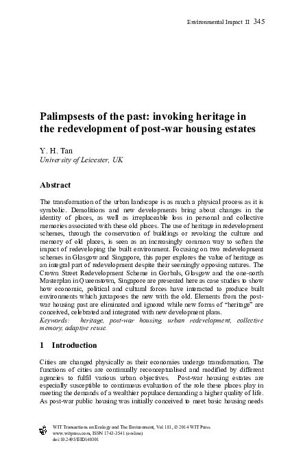
(a)
Figure 1:
(b)
(a) Queenstown, Singapore, 1961 (source: Low [18, p. 69]);
(b) Hutchesontown-Gorbals CDA, 1965 (source: Horsey [30]).
This paper will explore the utilisation of heritage to attain societal and
economic aims, in relation to the Crown Street and the one-north redevelopment
schemes. The paper will show how the representation of heritage in these two
cases is selective and strategic to sculpting a new image of the estate that will
appeal to a sophisticated market. On one hand, housing planners actively
historicised the post-war housing estate; while on the other hand, they were
obliterating the extant landscape and its existing social structure to create an
environment whereby the old complied with the needs of the new. The idealised
schemes reconstructed the past by fulfilling the demands of the buyers, thereby
ensuring profitability and economic viability. The selective elimination of
undesirable aspects from the post-war housing era, coupled with reconstructing
or revoking favourable events from the distant past, thus served the purpose of
keeping history “tidy and suitable” for contemporary uses [1].
2 Post-war housing changes in Glasgow and Singapore
Post-war housing research have predominately focused on the discussion of
issues within a single housing estate, in a single country or confined to the
western or Asian context. Home’s Of Planting and Planning: The making of
British colonial cities explored how British town planning concepts had been
exported worldwide. These concepts are modified and crafted in ways that suited
local conditions. With time, each former colony, such as Singapore, acquired
urban planning strategies that are reminiscent of its colonial administration but
updated to handle modern day challenges [2].
WIT Transactions on Ecology and The Environment, Vol 181, © 2014 WIT Press
www.witpress.com, ISSN 1743-3541 (on-line)
�Environmental Impact II
347
Sharing the same roots in early 1900s British town planning concepts, postwar housing in Singapore was conceived to meet the immense challenges of
post-war reconstruction and the rapid growth of the population. Various
researchers have discussed the lack of attention given to low-cost housing in
Singapore before the war. The Singapore Improvement Trust (SIT), though
established in 1927, was not “empowered as a statutory board to carry out
housing projects” for the masses [3]. This led on to widespread resentment
against the colonial housing authority, so much so after World War II, official
attempts to clear urban kampongs (villages) to build new public housing were
“deeply contested and frequently resulted in social and political conflict” [4].
This situation persisted until 1960 when the Housing Development Board (HDB)
was established as the self-governing colony’s housing authority. Since then,
HDB became synonymous with public housing in Singapore, with more than
87% of the population living and owning subsided HDB flats. In tandem with the
rapid industrialisation and economic growth in Singapore from 1965, public
housing has been discussed as a major “contribution towards higher wages and
productivity, political and social stability” thereby attracting “international
capital and manufacturing investments” into Singapore [5]. However
increasingly, the middle class is “rejecting public housing as a mass produced
consumer good”, thus necessitating the upgrade of existing post-war housing
estates to attract the middle class.
Like Singapore, Glasgow was known as a busy industrial port city which
facilitated trade within and beyond the British Empire. By the 18th century,
Glasgow had become a “boom town”, enriched by shipping and new world trade,
particularly in tobacco and cotton. By the 20th century, the city was renowned
for its innovative heavy industrial activities, such as ship and locomotive
building [6]. Rapid industrialisation of the city influenced the city’s urban
structure. Residential tenements and industrial buildings often stood side by side.
As the central area of the city became more crowded, industrial buildings and
workers’ housing started encroaching into the inner city where abandoned
middle-class tenement houses were taken over by workers. By the end of World
War Two, Glasgow continued to face problems such as overcrowding, poor
housing facilities and a dire need to house families displaced by the war.
Architecture in the form of post-war public housing was seen as the herald of
better living standards and a closure to the ravages of the war-time years. Slum
clearances and the construction of modern housing blocks were initiated in
Glasgow to eradicate the vestiges of tenements associated with the grim
Victorian industrial period. In 1954, the Glasgow Development Plan designated
the Gorbals, Govan and Royston inner city tenement areas for immediate
demolition and comprehensive redevelopment. The Hutchesontown
Comprehensive Development Area (CDA) Plan was subsequently submitted in
1956 and approved the following year. The redevelopment plan was phased over
20 years from 1957 to 1977 where five land parcels, Area A to E, were
developed. According to Thompson-Fawcett, the development of housing
projects in the inner city grew rapidly as the area was expected to “act as a
stimulant for further economic growth and attracting funds” for Glasgow [7,
WIT Transactions on Ecology and The Environment, Vol 181, © 2014 WIT Press
www.witpress.com, ISSN 1743-3541 (on-line)
�348 Environmental Impact II
pp. 181–182]. By the 1970s, housing developments in the Gorbals came to be
viewed as a critical factor in stimulating wider economic recovery in “housingled regeneration”. The Scottish post-war housing project was a success. At the
height of post-war housing programme worldwide in the 1960s, 79% of all new
housing developments in Scotland were built by the public authorities. Of which,
96% of Glasgow post-war housing was built by public authorities [8].
3 From Hutchesontown Area E to Crown Street
Part of the present Crown Street Redevelopment Project is situated in the former
Hutchesontown Area E. Construction was carried out between 1968 and 1974. It
consisted of 12 seven storeys linked deck access blocks with 759 flats and two
24 storey point blocks with 384 flats [9]. Soon after completion, the deck access
blocks were plagued by a plethora of building defects related to dampness, such
as black mould and rotting carpentry [7, p. 184]. The development was soon
given the unsavoury nickname “The Dampies”. After an intense tenants’
campaign, the local council agreed to relocate remaining residents and the blocks
were abandoned in 1980. The deck-access blocks were subsequently demolished
in 1987, leaving a 40 acre site which remained vacant for close to a decade [10,
p. 5].
(a)
Figure 2:
(b)
(a) Area E in 1974 (source: Reoch [31]) and (b) its demolition in
1987 (source: Crown Street Regeneration Project [32]).
The demolition of Hutchesontown E was the harbinger for more demolitions
within the Hutchesontown Comprehensive Redevelopment Area. By early
1990s, Gorbal’s post-war housing landscape had “lost its identity and the vacant
deck-access blocks lining principal thoroughfares depressed the environment.”
[11]. The Crown Street Regeneration Project was thus conceived in 1990 with
the intention to reverse unpopular CDA housing schemes and to develop
residential housing which will fill the “gaping hole in the urban fabric” after the
demolition of the 12 deck-access blocks in Area E [10, p. 6]. It was chosen for
both its visual and historical prominence in Glasgow. Apart from being close to
WIT Transactions on Ecology and The Environment, Vol 181, © 2014 WIT Press
www.witpress.com, ISSN 1743-3541 (on-line)
�Environmental Impact II
349
the city centre, Crown Street is also the “southern prolongation of High Street
and Saltmarket, the medieval north-south axis of Glasgow” [7, p. 185].
Undoubtedly, the prominence of the site meant that the Crown Street
Redevelopment Project was destined to become a showpiece for Glasgow, which
its planner hoped would serve as “a catalyst…which would attract further
investments, further confidence in the Gorbals as an area” [12].
4 Crown Street: the liveable city
Three years after the demolition, a major urban design competition was held in
1990 to redevelop the vacant 40-acre site as Crown Street Redevelopment
Project. It comprised of the former Area E, as well as the undeveloped land in
the west of Hutchesontown/Gorbals. Of the 4 architectural firms invited to
participate, CZWG Architects from London was chosen. A main feature of their
urban design scheme called for the “abolishment of the open Modernist spatial
conception and to recreate streets lined with façade of four-storey mixed tenure
housing enclosing communal gardens” [13]. The objective was to create a
“liveable city” which the planners claimed the CDA housing had failed to
provide. Life in the tower block was dismissed as a “hard-edged city life” which
caused “duress” and a lack of “dignity and calm”. The firm proposed adopting
the traditional tenement block and the Glasgow street pattern from the late 19th
century as a solution for improving the quality of life in Crown Street. By
denouncing the failures of the previous built environment and conjuring a
favourable image of historical built forms from an earlier phase of urban
development, an image of Crown Street as the idealised traditional Glasgow
neighbourhood was formed. The height of new perimeter blocks is controlled at
4 storeys to convey an impression of harmony and unity “like a late nineteenth
century neighbourhood” [10, p. 7]; while white and red sandstone cladding is
used on new housing blocks to mimic working-class 19th century tenement
blocks, which were hailed as “Glasgow’s archetypal building form” [11, p. 2].
The representation of heritage in Crown Street, however, is subjective. The
planners for Crown Street had appropriated heritage in order to make the
appealing to present buyers. Heritage was seen as part of a process of “careful
urban renewal” whereby the historic environment is recreated and reinterpreted
to be “more suitable for family and modern life” [11, p. 1]. For example, in a
traditional road hierarchy, thoroughfares were the widest roads as they had to
carry large number of motorists through a neighbourhood efficiently. Shops
would line the both sides of the boulevards as the location is favourable for quick
delivery of goods. However in Crown Street Redevelopment Project, planners
cited “present day conditions” to suggest that this hierarchy should be reversed.
A tree-lined boulevard was reintroduced on Crown Street, the thoroughfare of
the neighbourhood. It was, however, not meant for heavy traffic flow. Most
traffic in the neighbourhood is diverted to non-pedestrian roads on the fringe.
This leaves the Crown Street Boulevard largely empty. Al Fresco dining and
outdoor retail spaces were introduced on the walkways to create a “return to the
traditional shopping street” [7, pp. 190–192]. Instead of “the filth and
WIT Transactions on Ecology and The Environment, Vol 181, © 2014 WIT Press
www.witpress.com, ISSN 1743-3541 (on-line)
�350 Environmental Impact II
overcrowding of the city’s poor quarter” which Crown Street was known for in
the 19th century, the main thoroughfare of Crown Street is created in
reminiscence of shopping streets in Europe.
5 A new urban village in Glasgow
From its inception, Crown Street Redevelopment Project was conceived as a
housing programme that is different from the Comprehensive Development Area
tower block housing which had dominated the Gorbals’ skyline for three
decades. Crown Street Regeneration Project was presented with two distinct
execution plans where the planners deemed appropriate and appealing to buyers.
Glasgow Development Agency (GDA), a central government body primarily
concerned with economic development wanted to restore Glasgow’s tenement
housing form; while the Glasgow Planning Department preferred the singlefamily houses approach [15]. GDA eventually prevailed despite the reluctance of
private developers to be involved in constructing and marketing the new
housing. Developers were sceptical about reintroducing an old building typology
as part of revitalisation and they were aware of “the stigma attached to the
location” [7, p. 186]. The project therefore was largely dependent on public
funding and the public sector to execute the project.
The tenement housing in Crown Street only resembled original Gorbals
tenements in terms of building scale and façade treatment. The internal layout
and functions of the Crown Street housing block had deviated from the original
tenement significantly. Original Gorbals tenements were first occupied by
middle class and then the working class as Glasgow’s industries expanded. The
ground floor was used as shopfronts while upper floors were used for housing.
The internal layout of the tenement was flexible, changing over time to
accommodate different functions such as workshops and the inclusion of more
tenants. Residential and commercial functions in tenement areas were not
segregated. Invariably, they co-existed within the same building.
In contrast to the mixed residential and commercial nature of the old Gorbals
tenements, the new tenement blocks in Crown Street were meant for housing
only. Instead of shops on the ground floor, there were units of “maisonette
apartments with interior stairwells, three or four bedrooms and a small rear
gardens” on the lower floors [10, p. 12]. The design of the new housing blocks
catered to a wealthy clientele but lacked the flexibility of functions that 19th
century tenements could achieve. As the new housing scheme “desired to create
a community rather than another housing scheme” [11, p. 4], auxiliary facilities
were created instead of having the neighbourhood develop different functions
organically over time. A complementary “Urban Village” concept was mooted to
provide a range of facilities with the aim to help the neighbourhood succeed.
The “Urban Village” concept was led by the Urban Villages Forum which
included major land developers, local authorities and housing associations. It
called for a change to the segregation of housing, employment and retail in town
planning by proposing mixed-use developments that “create a balanced and more
sustainable urban regeneration” [17]. The aims of the Urban Villages Forum and
WIT Transactions on Ecology and The Environment, Vol 181, © 2014 WIT Press
www.witpress.com, ISSN 1743-3541 (on-line)
�Environmental Impact II
351
the Crown Street Regeneration Project were analogous. Both denounced the
modernist planning approach as a source of “unfriendly residential environments
characterised by vandalism, high crime rate and poor security”; likewise
both argued for the advantages of “traditional” 19th century mixed-use
neighbourhoods which were “dynamic, creative and able to regenerate
themselves”.
In Crown Street Project, this developed into new facilities such as business
centre, budget hotels, student accommodations and small offices. However, the
transliteration of the past to the present does not preserve the tenements’ essence.
19th century tenements had the flexibility to change internal space configurations
to suit commercial and retail needs, but the new units were not able to do so. The
planners’ need to create a self-sustaining, mixed-use environment within Crown
Street neighbourhood resulted in the introduction of new building forms and
urban layouts. Crown Street Redevelopment Project could thus be seen as a reimagined 19th century tenement neighbourhood driven by economic aims.
Recollection of the old Gorbals neighbourhood is invoked through heritage, yet
the past is also reimagined and appropriated to suit new urban and housing
conditions in the Crown Street Project.
6 Queenstown: the first satellite town in Singapore
Queenstown is the first satellite town established outside Singapore’s city area.
Planning policies first implemented in Queenstown by the Singapore
Improvement Trust (SIT) were subsequently modified and used in the Housing
Development Board (HDB) New Towns. The working party for Queenstown
was convened in 1953 with the aim of creating a self-sufficient town, complete
with health, educational, commercial, religious, recreational and infrastructural
facilities [18, p. 164]. It was however more pertinent in the post-war decade to
relocate local residents displaced by “redevelopment clearance schemes” in the
city and its fringe areas [19, p. 11]. These clearance schemes affected the
numerous clusters of unauthorised makeshift dwellings in the city area, also
known as urban kampongs. As many squatters worked in the city, kampongs
were located close to their workplaces. However, the prevalence of these
unauthorised kampongs caused problems such as overcrowding, poor sanitation
and difficulty in maintaining law and order. An order was issued by the
Municipal Housing Committee in 1947 to resolve the problem through
“demolition and re-housing”. Queenstown was selected to develop a “selfcontained and balanced” satellite town which would provide housing as well as
ample employment opportunities for these squatters [19, p. 11].
Britain’s New Town Act was enacted in 1946 for the provision of New
Towns in the country. The act was subsequently implemented in British colonies
such as Singapore. Unlike the recommended practice of deciding the population
of a new town before acquiring land for construction, the Queenstown working
party had to work with a pre-allocated 1150 acre site, acquired by the Municipal
Government in a piecemeal fashion from 1926 to 1946. Land was initially
acquired for railway and military purposes before it was handed to SIT after
WIT Transactions on Ecology and The Environment, Vol 181, © 2014 WIT Press
www.witpress.com, ISSN 1743-3541 (on-line)
�352 Environmental Impact II
(a)
Figure 3:
(b)
(a) SIT’s Queenstown Neighbourhood Plan (1954) (source: [19,
Appendix II]) and (b) HDB Queenstown Planning Report in 1994.
The red highlighted area shows the original size of Queenstown
Planning Area in relation to the 1990s expansion. Portsdown (Red
Dot) is designated the new nucleus of Queenstown (source: URA
[20, p. 7]).
World War II. An area to the east of the railway was retained by the British
Army for use as barracks and officers’ quarters. This area, the Pasir Panjang
Military Complex, remained in use until the army’s withdrawal from Singapore
in 1971.
Based on the size of the site, the Working Party had to consider factors such
as occupancy densities and the provisions of amenities, industrial areas and open
spaces. A figure of 6 persons per average dwelling unit was recommended after
studying the population census. This worked out to an average net residential
density of 200 persons per acre (ppa). This density allowed for high densities of
up to 400 ppa in tall blocks of flats and lower densities of about 150ppa in the
low rise blocks and terrace houses [19, pp. 12–13]. Two reasons were cited for
such an arrangement. Firstly, only low blocks and terrace houses could be built
on reclaimed swamplands while tall blocks built on firm grounds helped achieve
the required density. Secondly, Queenstown was intended as the first “balanced
society new town” that will attract people from all walks of life. A variety of
dwelling types were thus built to attract professionals and middle class to move
into the satellite town.
By the time SIT disbanded in 1960, only Princess Margaret Estate had been
completed. SIT had envisioned five neighbourhoods in Queenstown which
would be able to accommodate a population of 50,000. SIT’s succeeding
organisation, the Housing and Development Board (HDB) continued post-war
housing programmes and took over the planning and construction of
Queenstown. As Queenstown proved to be popular with flat applicants, HDB
decided to develop two more neighbourhoods. All seven neighbourhoods were
completed by mid-1970s with a total population of more than 150,000.
WIT Transactions on Ecology and The Environment, Vol 181, © 2014 WIT Press
www.witpress.com, ISSN 1743-3541 (on-line)
�Environmental Impact II
353
Queenstown not only played an important role in alleviating the post-war
housing problem, it became the showcase of HDB’s public housing efforts in the
1960–70s.
7 One-North: the “new” new town?
By 1990, most Queenstown flats were more than 30 years old. The sparsely
designed blocks no longer appealed to young Singaporeans. Young Queenstown
residents started shifting to other New Towns in the 1980s. The fall in population
was accompanied with the decline of industries in Queenstown. In its heyday
from 1960s to 1980s, Tanglin Halt Industrial Estate in Queenstown hosted
industrial heavyweights such as the Archipelago Brewery Company, Thye Hong
Biscuit Factory and Van Houten Chocolates. The 1985 economic recession,
however, dealt a heavy blow to Singapore’s manufacturing industry. By 1990s,
most of Queenstown’s factories had closed down or moved to other countries in
order to keep manufacturing cost low.
A Planning Report for Queenstown was thus produced by the Urban
Redevelopment Authority (URA) in 1994 to revitalise the Satellite Town. The
report identified Queenstown’s proximity to the universities, Keppel Harbour
and the Central Business District as advantages to start a “research-based, hightechnology industrial zone” [20, p. 12]. Portsdown Road, an area separated from
Queenstown by thick vegetation and the Malayan Railway Line, was earmarked
for development as a high-technology park and residential area. On 4 Dec 2001,
the name for the new business park, one-north, was unveiled during the
Masterplan exhibition [21].
Zaha Hadid was appointed as Masterplan Consultant to the project in 2000.
Her firm was chosen based on its world-class reputation and its track record for
“thinking out of the box”. The Masterplan envisioned a “work-live-play
environment” through locating research laboratories and high technology
industries with a variety of housing options and a vibrant “cultural scene” within
close proximity. It received much international acclaim and was valorised as the
“next generation model for the integration of business, research and urban
living” [22]. Yet the concept of integrating commercial and residential buildings
within the same development was not new. In many ways, planning concepts
found in Queenstown and subsequent New Towns were implemented in OneNorth development despite its “next-generation” moniker. Similar features
include having a variety of housing options to attract people from different
income groups and the provision of amenities close to residences. Visually, the
masterplan had used the hilly terrain to create an innovative “spatial repertoire of
natural landscape formations” [23]; ideologically however, the one-north
development had not deviated from the New Town planning model. It remains
very much reliant on the tested and proved town planning strategies implemented
by HDB. In this sense, though the public housing heritage of Singapore is not
celebrated, its planning strategy is constantly invoked in new developments. It
continues to provide HDB flat dwellers with a sense of familiarity and the
expectation of having amenities in close proximity.
WIT Transactions on Ecology and The Environment, Vol 181, © 2014 WIT Press
www.witpress.com, ISSN 1743-3541 (on-line)
�354 Environmental Impact II
8 Reimaging neglected sites as reclaimed heritage
Since Singapore’s independence in 1965, the former colonial entreport had
developed rapidly into an industrialised city-state. Development of the modern
built landscapes came at the price of demolishing built heritage. Large swaths of
land were acquired to develop housing estates, office towers and shopping
complexes. Rapid and wholesale landscape changes within a generation had
caused Singaporeans to feel a loss of identity. The older generation lament the
disappearance of an intangible “kampong spirit” or community camaraderie
which bonded people of different races together [24].
Conservation of existing buildings is frequently used in redevelopment
projects since the 1990s to mitigate the effects of dislocation. Akin to how the
one-north development had continued to rely on long-standing housing planning
strategies, conservation of existing landmarks was aimed at retaining existing
residents’ sense of familiarity while preparing them for changes to their physical
environment. In the revitalisation project for Queenstown, Prime Minister Lee
highlighted the integration of old landmarks in new environments as essential to
“retaining the memories and the character of the place”. This sense of familiarity
is the “something extra which will bring people back” [25]. Yet conservation
efforts tend to be selective, agenda-driven and pastiche as PM Lee also
mentioned how “the wet market doesn’t need look like a wet market anymore”,
hence only the shell of building is left to evoke memories even though its
functions and users had changed according to new needs [26].
(a)
Figure 4:
(b)
(a) Colonial “black and white” bungalows and (b) low-rise
apartments used as military accommodations in Portsdown Road
(sources: (a) The Trek to a Rustic Old Town,
http://myqueenstown.blogspot.com, retrieved on 5 Mar 2012 and
(b) Rochester Park, http://cbsingapore.blogspot.com/, retrieved
on 5 Mar 2012).
WIT Transactions on Ecology and The Environment, Vol 181, © 2014 WIT Press
www.witpress.com, ISSN 1743-3541 (on-line)
�Environmental Impact II
355
Portsdown Road area in the one-north development is an example of how
“little bohemia” are imagined and valorised for national development. As office
blocks designed by architects such as Zaha Hadid were constructed in one-north,
the former Black and White bungalows and low rise apartment blocks left behind
by the British Army were taken over as residences for expatriates and
Singaporeans working in one-north. The area was marketed as a “Little
Bohemia” in which the entrepreneurial culture could be fostered amidst an
idyllic setting [27, pp. 77–80].
The concept of “Little Bohemia” was first promoted by then Senior Minister
Lee Kuan Yew in a speech about how an entrepreneurial culture could be
developed in Singapore. Lee mentioned “little bohemia” as spaces in which
“alternative values, ideas and lifestyles may be tolerated, without contaminating
the Asian values of the majority living in public housing estates”. Such a notion
was elaborated by several other ministers such as then Prime Minister Goh and
Deputy Prime Minister Tan. The former military housing at Portsdown Road was
identified as a favourable site for such a purpose. It is located within
Queenstown as part of the new one-north development, yet remains physically
segregated from existing housing estates by railway tracks and thick vegetation.
These black and white houses were largely neglected after the British Army’s
departure in 1971. Units were rented out cheaply to non-Singaporeans who could
neither purchase HDB flats nor afford to rent flats and private accommodations.
After Portsdown Road was promoted as a “Little Bohemia”, the rental of
conserved and refurbished units was restricted only to people in the creative
industries or those working in one-north. It fulfilled Jurong Town Corporation’s
(JTC) objective to create an “environment where talents, entrepreneurs, scientists
and researchers would congregate, exchange ideas and interact” [28]. In effect,
this elitist community is isolated physically and ideologically from the rest of the
“conservative” Singapore society. An image of an “intellectually stimulating and
creative environment” is invented to promote Portsdown Road’s alternative
lifestyle enclave.
Perception of Portsdown Road had changed over the last three decades from a
utilitarian military housing estate to a neglected backwater neighbourhood and
now a highly sought-after “Little Bohemia”. This shows how a historic
environment can be reimagined, revived and regulated based on changes to
regional and national agendas. About 60% of Portsdown Road’s black and white
houses and walk-up apartments were conserved by JTC, while the remainder
were demolished. The conservation of these houses was justified as they served
as physical embodiments linking past economic struggles and the current
national agenda for global success [27, p. 79]. Much as the developer and
planners extolled how Singaporeans must not “disregard our heritage or risk
losing elements that have brought success”, their reasoning is unsound. The
military houses were neither a part of Singapore’s economic success nor were
they previously recognised as part of the nation’s built heritage. Unlike
vernacular shophouses which were occupied by people of all races, these military
accommodations were initially seen as negative vestiges of colonial power in the
WIT Transactions on Ecology and The Environment, Vol 181, © 2014 WIT Press
www.witpress.com, ISSN 1743-3541 (on-line)
�356 Environmental Impact II
(a)
Figure 5:
(b)
(a) Single storey buildings are created in the new Wessex Village
Square. These buildings are designed to look similar to existing
ones such as the relocated ColBar (b). (Sources: (a) Fringe Benefit
Gallery, http://fringebenefitsgallery.com/, retrieved on 5 Mar 201
and (b) Colbar, http://epicurative.blogspot.com/2006/04/reviewcolbar-after-seeing-it-reviewed.html, retrieved on 5 Mar 2012.)
early years of nationhood. The rediscovery of the historical Portsdown Road is
thus a romanticised narrative aimed to increase one-north’s market appeal.
Like perceptions, the built landscape is susceptible to changes. The former
military housing units on Portsdown Road were designed to serve as
accommodations for soldiers rather than families. During the 1950–70s, the
bases in the former Pasir Panjang Military Complex were the most important
landmarks in the area. Military bases form important hubs of activities while the
black and white military accommodations merely occupied the periphery. As
Portsdown Road was re-imagined as a bohemian residential area, this perspective
had been reversed. Ageing disused military bases were demolished, leaving
behind the black and white houses and apartment blocks. A portion of these
apartment blocks were pulled down to create a new town centre for the “Little
Bohemia”. Art galleries and were built in this new “Wessex Estate Centre”. They
were designed as single-storey standalone buildings to blend in with the
surrounding low-rise houses. Likewise building forms and the material of these
structures, such as the gabled roof with clay roof tiles and timber al-fresco dining
decks, were chosen to evoke an image of an idyllic colonial town. The
cornerstone of the town centre is Colbar, or Colonial Bar, a neighbourhood
eatery that has been operating near the military bases since 1953. The restaurant
was forced to move in 2002 as the bases closed down and the land was acquired
to build a new road. Instead of demolishing the restaurant, it was carefully
dismantled from its original location near the entrance of the military base and
reassembled at its new location at the centre of Wessex Estate. The architecture
of the eatery is unremarkable, yet every element of the simple timber frame
building, from its orange clay roof tiles to its original 1950s countertop and
display cabinets, was preserved and relocated. It was as though the restaurant had
always existed in that location. The restaurant was preserved not only because it
will serve as the new “gathering place for the Wessex community and bohemian
WIT Transactions on Ecology and The Environment, Vol 181, © 2014 WIT Press
www.witpress.com, ISSN 1743-3541 (on-line)
�Environmental Impact II
357
people” [40]. It also lends legitimacy to the “new” heritage qualities of
Portsdown Road and helped enforce the image of a Bohemian enclave, where a
faux colonial lifestyle is created and celebrated.
9 Conclusion
It is inevitable that post-war housing developments need to be re-imagined and
redeveloped. Firstly, the image of cheap and monotonous housing for a needy
post-war population no longer resonated with the affluent middle class and a
global-trotting community. Secondly, post war housing estates were built upon
the total annihilation of the pre-war built environments. People often felt a sense
of dislocation in these public housing developments. Many yearn for a return to
the idealised past.
Invoking heritage through recreating and appropriating the historical
environment is seen as a way to provide continuity between the past and the
future. Catch phrases such as “Urban Village” and “Little Bohemia” instantly
conjured images of historic environments with modern amenities. Heritage is
marketed in the Crown Street Project and the one-north Masterplan development
to increase their appeal. Control and manipulation of the historic environment
was also aimed at creating an unambiguous and idealised historical narrative
which would appeal to house buyers.
The historical environment is seemingly static yet the two cases had shown
that historic environments could be moulded to fit different economic and social
agendas. However, as different agencies freely interpret and re-imagine these
landscapes, they become active agents who shaped the transformation of cities.
As history is selectively represented in such environments, conserved or
recreated historic buildings often become palimpsests of their past.
References
[1]
[2]
[3]
[4]
[5]
[6]
Lowenthal (1975) Past time, present place: Landscape and Memory, The
Geographic Review LXV (1) pp. 27–28
Home (1997) Of Planting and Planning: The Making of British Colonial
Cities, E& FN Spon, London, pp. 1–7
Tan & Pang (1991) The Singapore Experience in Public Housing. Times
Academic Press, Singapore
Loh (2009) Conflict and Change at the Margins: Emergency Kampong
Clearance and the Making of Modern Singapore, Asian Studies Review,
Vol. 33 (June) p. 139
Wong and Yap (2002) From universal public housing to meeting the
increasing aspiration for private housing in Singapore, Habitat
International 27, p. 363
Moss and Hume (1977) Workshop of the British Empire: Engineering and
Shipbuilding the West of Scotland, Heinemann, London
WIT Transactions on Ecology and The Environment, Vol 181, © 2014 WIT Press
www.witpress.com, ISSN 1743-3541 (on-line)
�358 Environmental Impact II
[7]
[8]
[9]
[10]
[11]
[12]
[13]
[14]
[15]
[16]
[17]
[18]
[19]
[20]
[21]
[22]
[23]
[24]
[25]
[26]
[27]
[28]
[29]
Thompson-Fawcett (2004) Reinventing the Tenement: Transformation of
Crown Street in the Gorbals, Glasgow, Journal of Urban Design, Vol 9
No 2, pp. 181–182
Glendinning (2011) Postwar Mass Housing in Glasgow and Scotland: An
Overview, EAHN-DOCOMOMO Tour
Glendinning and Muthesius (1994) Tower Block, Yale University Press,
New Haven, p. 368
Urban (2011) Built historiography in Glasgow’s New Gorbals-the Crown
Street Regeneration Project, Journal of Art Historiography Number 5, p. 5
Galloway (1995) Crown Street Regeneration Glasgow, p. 1
Glendinning (1998) Lecture: Multi-phase modernity: Glasgow’s Gorbals,
p. 8
Galloway (1995) Crown Street Regeneration Glasgow, p. 1
Thompson-Fawcett (2004) Reinventing the Tenement: Transformation of
Crown Street in the Gorbals, Glasgow, Journal of Urban Design, Vol 9
No 2, pp. 190–192
Varady (1996) Neighborhood Regeneration of Glasgow Southside:
Implication for American Cities, Journal of Urban Design, Vol 1 Issue 2,
p. 203
Galloway (1995) Crown Street Regeneration Glasgow, p. 4
McArthur (2000) Rebuilding sustainable communities, Town Planning
Review, Vol 71 (1) p. 51
Low (2007) 10 Stories Queenstown Through the Years, National Heritage
Board, Singapore
SIT (1958) Final Report of the New Towns Working Party on the Plan for
Queenstown, Tien Wah Press Ltd, Singapore, p. 11
URA (1994) Queenstown Planning Area Planning Report 1994
Tan (2001) Speech at launch of Science Hub, by Deputy Prime Minister, 4
Dec
Architecture and Urbanism (2002) “Zaha Hadid’s Masterplan for onenorth in Singapore completed” Vol. 2, pp. 7–9
Zaha Hadid Ltd (2001) One North Masterplan, http://www.zahahadid.com/masterplans/one-north-masterplan/
Jones (2006) Palimpsest of Progress: Erasing the Past and Rewriting the
Future in Developing Societies, International Journal of Heritage Studies,
Vol 12 (2) p. 124
Lee (2007) National Day Rally Speech, http://www.pmo.gov.sg
Chang and Huang (2005) Recreating Place, Replacing Memory: Creative
destruction at the Singapore River, Asia Pacific Viewpoint, Vol 46 (3)
pp. 267–280
Wong and Bunnell (2006) New Economy Discourse and Spaces in
Singapore, Environment and Planning A Vol 38
JTC
Corporation
(2001)
Press
Release,
4
December,
www.jtc.gov.sg/Coporate/mdeia+room/4dec2001.asp
Chong (2003) Launch of Fusionopolis, 20 Feb. http:// www.onenorth.com/ pages/pop-ups/news/content/speech12.htm
WIT Transactions on Ecology and The Environment, Vol 181, © 2014 WIT Press
www.witpress.com, ISSN 1743-3541 (on-line)
�Environmental Impact II
359
[30] Horsey (1990) Tenements and Towers, RCAHMS, Edinburgh, p. 41
[31] Reoch (1976) Farewell to the Single End, The City of Glasgow District
Council, Scotland, p 47
[32] Crown Street Regeneration Project (1992) Crown Street Regeneration
Project: Past, Present and Future, Glasgow, p. 20
WIT Transactions on Ecology and The Environment, Vol 181, © 2014 WIT Press
www.witpress.com, ISSN 1743-3541 (on-line)
�
 Ian Tan