Academia.edu no longer supports Internet Explorer.
To browse Academia.edu and the wider internet faster and more securely, please take a few seconds to upgrade your browser.
The role of traditional geophysical methods in evaluating mine sites in England and Wales
The role of traditional geophysical methods in evaluating mine sites in England and Wales
 Armin Schmidt
Related Papers
Near Surface Geophysics
Geophysical characterization of derelict coalmine workings and mineshaft detection: a case study from Shrewsbury, United Kingdom2008 •
The role of traditional geophysical methods in evaluating mine sites in England
and Wales
by
Vernon, R.W., McDonnell, J.G., and Schmidt, A.
Department of Archaeological Sciences, University of Bradford, England.
Introduction
Research at the University of Bradford (Vernon et al. 1999, 2002; Vernon 2005) has shown
that interpretable geophysical results can be obtained from complex smelting sites so why not
from complex mine sites?
A few 16th century mine sites have been geophysically surveyed in the Vosges,
France (Ancel and Fluck 1990; Grandemange 1990) but such sites can be relatively
uncomplicated when compared to 19th century remains. Disused metal-mine sites contain
many elements that can make geophysical data acquisition virtually impossible, for example
iron debris, porous rubble and dense vegetation. Surveys may also be limited by shafts and
spoil tips with steep slopes. At the shaft top there can be an engine house for pumping and
winding machinery, and small workshops. Magnetometer and earth resistance surveys
however, might detect spreads of ferrous debris and walling, respectively associated with
those structures.
Geophysical surveys, using the Geoscan FM 36 fluxgate gradiometer and the Geoscan
RM15 earth resistance meter, have been conducted around the shaft top areas of three 19th
century lead mines in Britain. This paper outlines the failures and successes of these surveys.
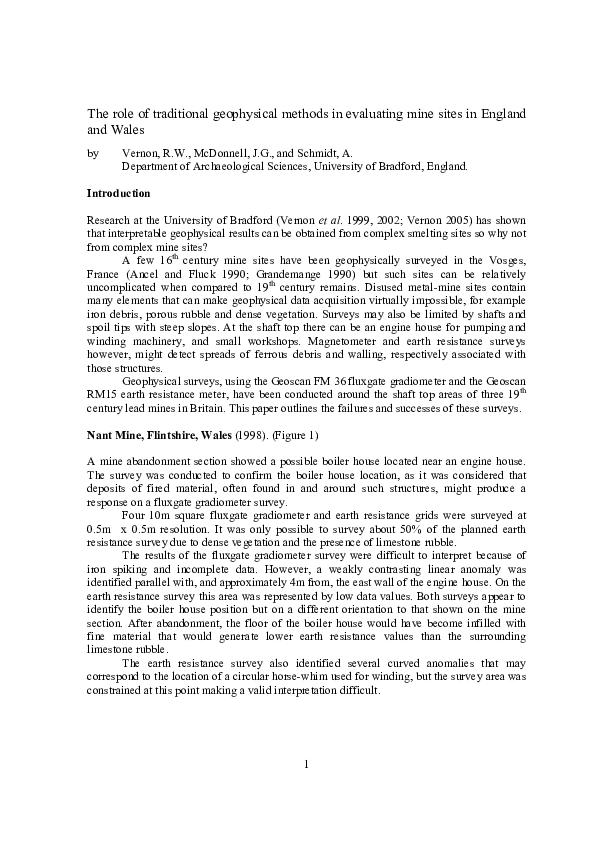
Nant Mine, Flintshire, Wales (1998). (Figure 1)
A mine abandonment section showed a possible boiler house located near an engine house.
The survey was conducted to confirm the boiler house location, as it was considered that
deposits of fired material, often found in and around such structures, might produce a
response on a fluxgate gradiometer survey.
Four 10m square fluxgate gradiometer and earth resistance grids were surveyed at
0.5m x 0.5m resolution. It was only possible to survey about 50% of the planned earth
resistance survey due to dense vegetation and the presence of limestone rubble.
The results of the fluxgate gradiometer survey were difficult to interpret because of
iron spiking and incomplete data. However, a weakly contrasting linear anomaly was
identified parallel with, and approximately 4m from, the east wall of the engine house. On the
earth resistance survey this area was represented by low data values. Both surveys appear to
identify the boiler house position but on a different orientation to that shown on the mine
section. After abandonment, the floor of the boiler house would have become infilled with
fine material that would generate lower earth resistance values than the surrounding
limestone rubble.
The earth resistance survey also identified several curved anomalies that may
correspond to the location of a circular horse-whim used for winding, but the survey area was
constrained at this point making a valid interpretation difficult.
1
Cononley Mine, North Yorkshire, England (1999). (Figure 2)
A small pumping engine house occupies the west side of this extensive mine site. The
purpose of the survey was to identify the location and dimensions of the boiler house and a
small workshop built against the engine house wall in the 20th century.
The survey consisted of three 10m square fluxgate gradiometer and earth resistance
grids at 0.5m x 0.5m resolution on the north side of the engine house, and east towards the
boiler house chimney.
The fluxgate gradiometer survey identified the boiler house walls as distinct linear
positive anomalies at ranges between -100 to 100nT. On the earth resistance survey an area
of low resistance coincided with the interior of the boiler house. Values increased towards the
chimney suggesting the presence of collapsed walling.
Some positive data were recorded around the possible site of the workshop on the
fluxgate gradiometer survey but they were not confined to a specific area. The initial earth
resistance survey was less promising. The mobile probes were set at 0.5m spacing and several
areas of high earth resistance data corresponded to deposits of mineral dressing residues.
When the area was resurveyed with a mobile probe spacing of 1m, two linear high earth
resistance anomalies were identified that corresponded to the foundations of the workshop
walls.
Magpie Mine, Derbyshire, England (2004). (Figure 3)
The survey was conducted on this scheduled monument to identify the location of a mid-19th
century boiler house for a small winding engine. It had been originally brought to this site
from a mine site currently being excavated. The survey was conducted to see if the
configuration of the equipment on both mine sites was similar. Unlike the Nant and Cononley
mine surveys, this survey area was undulating and was located about 50m to the south of, and
some 6m lower than, the shaft top.
The fluxgate gradiometer and earth resistance surveys consisted of eight 10m square
grids surveyed at 0.5m x 0.5m resolution. Iron debris was common in the survey area, but the
fluxgate gradiometer survey identified two short linear anomalies trending roughly northeast
from the vicinity of a chimney and adjacent forge. However, below a range of –100 to 100nT
they become lost in the overall responses produced by iron spiking. The earth resistance
survey identified a pronounced narrow linear anomaly of high earth resistance data that
probably represents the partially collapsed western wall of the boiler house. An irregular
pseudo-linear cluster of higher values that correspond to a topographical change is believed
to represent the west wall.
When the results are compared the anomalies that represent the west wall of the boiler
house do not match exactly. However, the two techniques respond to different physical
parameter. The fluxgate gradiometer does not respond to the non-magnetic limestone walls,
but will respond to any magnetic material that may lie within the boiler house or against the
walls. The earth resistance survey will respond to the actual walls, and linear anomalies
represent the position of the boiler house walls. When the results were compared with
structures on the site, it was realised that the chimney and the forge adjacent to the survey
were actually part of the boiler house.
2
Conclusions
The three examples show that it is possible to collect interpretable results from geophysical
surveys over mine sites. Historical research and an understanding about how the mine site
functioned compliment them. It is an area of research that extends the use of archaeological
prospection into complex industrial areas.
References
Ancel, B. and Fluck, P. 1990. Sainte-Marie-aux-Mines, Secteur de L’Altenberg, Vallee de Fertrupt:
Etude souterrainne del la Porte de Fer, un reseau medieval repris au XVIème Siecle (Sondage 1988).
in Pierres et Terre 34, Federation Patrimoine Minier, Ste. Marie-aux-Mines. 78-80. (In French)
Grandemange, J. 1990. Le Samson: Ateliers et Habitats d'une Mine D'Argent du XVIeme Siecle. in
Pierres et Terre 34, Federation Patrimoine Minier, Ste. Marie-aux-Mines. 116-120. (In French)
Vernon, R.W., McDonnell, G. and Schmidt, A. (1999) Medieval iron and lead smelting works: a
geophysical comparison. In Pollard, A.M. (ed) Geoarchaeology: exploration, environments,
resources. Geological Society, London Special Publication. 165 15-34
Vernon R., McDonnell G. and Schmidt A. 2002. The geophysical evaluation of British lead and
copper working sites. Comparisons with iron working. Archaeological Prospection 9. 123-134
Vernon, R.W. 2005. Application of Archaeological Geophysical Techniques to the Investigation of
British Smelting Sites. Unpublished PhD Thesis. University of Bradford.
1b
1c
1d
Engine
House
Fluxgate gradiometer data.
-20nT (White) to 20nT (Black)
Earth resistance data.
340 (White) to 600 (Black)
Boiler house?
Trace of horse
whim circle?
Figure 1. The Nant Mine Engine House.
1a. The engine house with the chimney from
the boiler house.
1b. The fluxgate gradiometer survey.
1c. The earth resistance survey.
1d. Interpretation.
1a
The survey of four 10m grids was conducted
between the engine house and the chimney.
3
2a
Survey
grid
2c
E.H.
E.H.
Chimney
5m
a) Fluxgate gradiometer survey and grid
50nT (white) to 50nT (black)
2b
Structures survey
by M.Roe. 1998.
Figure 2. The Cononley Mine Engine House.
E.H.
E.H.
5 (white) to
56 (black)
Mobile probes 0.5 m
15 (white) to
110 (black)
Mobile probes 1.0m
2a. The fluxgate gradiometer survey fitted to
the 10m survey grid.
2b. The earth resistance survey at different
mobile probe spacings.
2c. Interpretation. Boiler house (B) from
fluxgate gradiometer survey. Workshop
foundations (W) from earth resistance survey.
b) Earth resistance surveys.
3a
E.H. = Engine House.
20th century
winding house.
3b
Original
boiler house
19th
century
winding
engine.
F
F = Forge.
0
metres
20
0
Flue
metres
20
Chimney
Figure 3. The Magpie Mine Engine House.
3a. The fluxgate gradiometer survey. -80nT (white) to 80nT (black)
3b. The earth resistance survey. 20 ohms (white) to 220 ohms (black)
The surveys proved that the walls of the forge and the chimney were originally part
of the boiler house. The chimney was later modified with the addition of the flue.
4
RELATED PAPERS
International Journal of Accounting
The International Journal of Accounting Vol 52 Issue 3 2017 39 55 dikonversi2017 •
Frontiers in Psychology
Independent and Combined Effects of Socioeconomic Status (SES) and Bilingualism on Children’s Vocabulary and Verbal Short-Term Memory2017 •
Contemporary Health Issues and Environmental Impact
Climate Change and Aedes Mosquito Vector: A Projection towards Future Scenario of Disease Transmission2018 •
Journal of Education and Development (JED). Volume 2: Issue 2,
The Hehe Noun Class Prefixes and their Occurrences in the Noun Phrases: A Descriptive Approach2023 •
Dep. Disseny i imatge. UB
Investigación de la eficacia en el signo visual.2018 •
2007 •
2016 •
2007 •
2018 •