Academia.edu no longer supports Internet Explorer.
To browse Academia.edu and the wider internet faster and more securely, please take a few seconds to upgrade your browser.
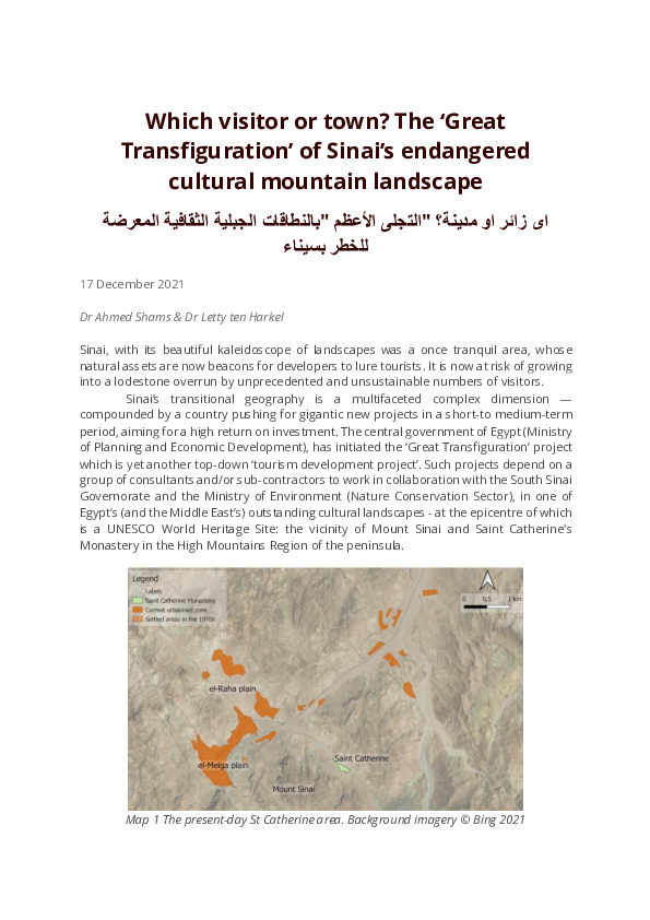
Which visitor or town? The 'Great Transfiguration' of Sinai's endangered cultural mountain landscape
Which visitor or town? The 'Great Transfiguration' of Sinai's endangered cultural mountain landscape
 Letty ten Harkel
2021, EAMENA blog
Related Papers
مجلة کلیة الآداب . القاهرة
الأغنیة الشعبیة و رؤیة الظواهر الطبیعیة مقاربة أنثروبولوجیة لبعض قرى محافظة بنی سویف2020 •
DergiPark (Istanbul University)
Suriyeli Göçmenler ve Dini Hayat: Uyum, Karşılaşma, Benzeşme Gaziantep Örneği / Syrian Refugees and Religious Life: Compliance, Encounter, Similitude: The Case of Gaziantep / المهاجرون / النازحون السوريون والحياة الدينية: تكيُّف، اندماج، مقارنة، تشابه؛ غازي عنتاب نموذجا2017 •
Critical Studies in Texts & Programs of Human Sciences
To Visit of the Visit A Critique of the Book: Exhibiting Photography2017 •
Iraqi Journal of Architecture and Planning
أثر المعالم الدينية في مخطط المدينة العربية الاسلامية2018 •
يعد المعلم الديني أحد أهم العناصر المكونة للمدن الدينية ومنها المدن العربية الاسلامية والتي تشكل احد مكونات الهيكل العمراني، إذ تبرز اهمية المعلم الديني من خلال الانتماء الديني (الروحي) لشاغلي المدن، كما تعد من العناصر العمرانية المميزة والمعرفة للهوية العمرانية، والتي رسمت الصورة الذهنية لبنية المدن الدينية في ذاكرة الناس الجمعية. إذ اعتمد البحث دراسة المخطط في المدن الدينية وتحديداً المدينة العربية الاسلامية؛ لأهميتها الدينية ووضوح أثر العامل الديني في نشأتها وتخطيطها، ومن خلال استعراض الدراسات السابقة التي تناولت تحليل المدينة العربية الاسلامية حددت المشكلة البحثية: "بوجود قصور معرفي حول الدور التنظيمي للمعالم الدينية في تخطيط المدينة العربية الاسلامية"، وعليه صيغت فرضية البحث: بان للمعالم الدينية دوراً تنظيمياً في تخطيط المدينة العربية الاسلامية، بأثره على الارتباطات المحورية وعلى المستويين الشمولي والموضعي. عرف البحث المعالم الدينية بأنها: الشواخص أو العناصر العمرانية ضمن مخطط المدينة التي تمتاز بهيئة شكلية حاضرة في ذاكرة الناس الجمعية، والتي تتمثل بدور العبادة بشكل ع...
RumeliDE Dil ve Edebiyat Araştırmaları Dergisi
المخطوط العربي الإسلامي في غينيا سبل الحفاظ عليه ووسائل نشره2023 •
Journal of Association of Arab Universities for Tourism and Hospitality
Portrayed Calligraphies in the Form of Animals in Islamic Art in India: The Invocation of "Nadi Ali" Executed in the Form of a Lion as a Model2022 •
The artifacts exhibiting the invocation of Nadi Ali in the form of a Lion are amongst the prominent artistic formations produced by the Indian school, Shiite doctrine one, These formations mix the lion's shape with several Arabic scripts to display a unique artistic form, which is considered a model of Portrayed Calligraphy in the form of animals and birds, or rather "Zoomorphic Calligraphy". At first sight, such calligraphies seem a depiction of an animal or a bird's shape, but with a careful scrutiny one figures out it is an outline of a word, or a sentence or maybe a complete text. The research's problem is mainly the shortage of the available Arabic studies about the Portrayed Calligraphy in Islamic art in general, and the artistic models of Nadi Ali's invocation in particular, as the study's sample which will be analyzed through the research is exhibited in worldwide museums, or published in periodicals issued in Foreign Languages. The research aims to give an overview of the portrayed calligraphy in general, make clear the importance of Nadi Ali's invocation for the Shiites, determine the reason for choosing the lion to form the invocation of Nadi Ali, throw light upon the effect of the Iranian art on the Indian one, clarify the utilized scripts in forming the Lion's shape and to describe the utilized colors and vegetal patterns.
Journal of University of Raparin
Koya District in the Stone AgesThe Stone Ages are considered the longest age’s humans have lived on earth. These periods were named after the technical aspect of using stone mainly along with wood and bone to make tools used in one's daily life in those periods. The division of these periods came on the basis of the shape and method of making the stone machines and the types of stones used to make them. The Koya district, as a part of the Iraqi-Kurdistan region, includes many archaeological sites dating back to these periods which are represented by a number of caves, shelters, valleys, and river banks, which times date back to different stages of these periods. According to the archaeological surveys that have been carried out in the areas of the Koya district and the visits to different areas of the district and the research that we have carried out, it has become clear to us that the Stone Age of the region, like the rest of the Kurdistan region, is divided into several roles, such as Paleolithic,...
Journal of hayat
An Overview of Critical Ethnography2015 •
شور عاونا زا يكي يفارگونتا هبنج ققحم نآ رد هك تسا يفيك قيقحت ياه و يداـقتعا ،يـشزرا ياه يـم رارق هعلاطم دروم عماوج اي دارفا زا يهورگ رد ار يگنهرف دـهد . ماـجنا عـقاو رد يداـقتنا يفارگوـنتا نيمه هورگ و دارفا رادتقا و هاگياج ،ژيتسرپ ،تردق رب زكرمت اب راك تـسا يعاـمتجا ياه ) 1 ( . تاـعلاطم رد يم زكرمت دارفا نيب تلاماعت رب ييارقتسا يقطنم اب رگشهوژپ يفارگونتا ار گـنهرف رد هتفهن يناعم ات دنك مك شقن هك يدارفا تمس هب ار رگشهوژپ هجوت يداقتنا دركيور و دنك فشك ،دـنراد تلاماـعت نيا رد يرت يم بلج دنك ) 2 ( . Madison زا لقن هب Thomas فدـه اـب كيـسلاك يفارگوـنتا كـي ار يداقتنا يفارگونتا يم يسايس موق نآ رد هك دناد هب اهنت راگن شنك يناعم حيضوت لابند ،تـسين صاـخ تفاب كي نورد رد اه يم هكلب اب لباقت رد يناعم نيا هك دنادب دهاوخ هدرتسگ راتخاس يـم فيـصوت هـنوگچ تردق رت دنوـش ) 3 ( . هصرع يمامت رد بيترت نيدب يم رارق تردق تابسانم ريثأت تحت تلاماعت هك يياه يداـقتنا هاگدـيد ،درـيگ يم حرطم دوش . تنا يفارگونتا تملاس تاعلاطم رد يمهم شقن يداق دارـفا رثكا ،دراد يراتسرپ رد هژيو هب نز هفرح نيا كـشزپ هدـيچيپ تلاماـعت...
Cuestiones teológicas 51 (115)
La dignidad de la imagen divina en Gregorio de Nisa ante las esclavitudes del presente - The dignity of the divine image in Gregory of Nyssa in the face of present-day slaveries2024 •
In this presentation we propose to reflect on the way in which the thought of Gregory of Nyssa sought to restore to their place of greatness persons and entire social groups that had been demeaned or neglected in the society of his time. We will attempt to confront Nyssen's living thought with the painful reality of the enslavements of our century. Although this approach might be considered to go beyond the specific scope of the History of Philosophy, those of us who investigate philosophical ideas find that many of them have an enduring influence and transcend their original historical context. First, we will briefly discuss the phenomenon of social slavery and asymmetries, both in Gregory of Nyssa's era and in our own. Then, in the section entitled “A Call to Conscience,” we will analyze the novel Gregorian anthropological theory, which rests on his radical interpretation of the divine image in the human being, and we will indicate some of its philosophical sources and its main elements: the fullness of perfections, its intrinsic dignity, equality and freedom. The final part of the paper, “A Call to Action,” will dwell on the practical consequences of Nyssen’s anthropology, his original conception of compassion, of the possible transformation and equalization of humanity according to the divine image, as well as the powerful relevance of these ideas for our time.
RELATED PAPERS
Perspectivas em Análise do Comportamento
Ciência, Análise do Comportamento e a Prática Baseada em Evidências em Psicologia2018 •
Mahalle, oda, komşu, misafir?
Mahalle, oda, komşu, misafir? Oda Projesi, 2005.2005 •
arXiv (Cornell University)
Ultrasound cavitation and exfoliation dynamics of 2D materials re-vealed in operando by X-ray free electron laser megahertz imaging2023 •
2011 •
Journal of Vascular Surgery
VESS12. Early and Intermediate Outcomes of Open Versus Fenestrated Repair of Complex Abdominal Aortic Aneurysms2016 •
DergiPark (Istanbul University)
Hulâsatü’l-beyân fî tefsîri’l Kur’ân’da Temsîlî Anlatım-Bakara Suresi Özelinde2022 •
2019 •
Revista Brasileira De Zootecnia
Digestibilidade e ganhos em peso de ovinos alimentados com diferentes fontes de volumosos e recebendo somatotropina recombinante bovina (rBST)1999 •
2008 •
Isfahan University of Technology - Journal of Crop Production and Processing
Investigation of the Best Method for Winter Pruning of Kiwifruit (Actinidia deliciosa L., cv. Hayward)2013 •