- Christian-Albrechts-Universität zu Kiel, Excellence Cluster ROOTS, Post-DocKing's College London, King's Digital Lab, Department Member, and 2 moreadd
- Archaeology, Prehistoric Archaeology, Near Eastern Archaeology, Agriculture, Experimental Archaeology, Neolithic Archaeology, and 26 moreBioarchaeology, Archaeological Science, Environmental Archaeology, Egyptian Archaeology, Archaeobotany, Stable Isotope Analysis, Levantine Archaeology, Palaeoenvironment, Irrigation, Building Materials (Archaeology), Water History, Anatolian Archaeology, Mesopotamian Archaeology, Early Farming Societies, Climate Change, Climate Change Adaptation, Resilience, Ancient Near East (Archaeology), Syria (Archaeology), Neolithic, Archaeology of Jordan, Societal adaptations to climate change, Archaeology of the Southern Levant, Palaeoclimatology, Ancient Near East, and Neolithic Transitionedit
- My research covers a wide range of topics and periods, which (mostly) have in common an interest in environment-peopl... moreMy research covers a wide range of topics and periods, which (mostly) have in common an interest in environment-people interactions and a focus on the Near East.
My current research focuses on the effects of climatic changes on societies in the Holocene Near East. At the moment I am studying the oxygen and carbon isotopes and trace elements of a speleothem from Iraqi Kurdistan. This 2500-year old stalagmite gives a record of moisture, allowing for a comparison between climatic and socio-economic change for the Iron Age, Achaemenid, Hellenistic, Parthian, Sasanian, and Islamic periods.
I also look into the Neolithic, during which short-lived cool and arid events, such as the 9.2 and 8.2 ka BP events occurred. I have ciritically re-evaluated available archaeological data, foremost by a reappraisal of archaeological chronologies to assess synchronocity of climate events and changes visible in the archaeological record. The results of this research have been published in Quaternary Science Reviews.
For my PhD research, I studied the use of carbon and nitrogen stable isotope analyses of plant remains for reconstruction of crop water status, to infer water management practices. I took part in experimental crop growing in Jordan, undertook experimental charring and burial of cereal grains, and applied the method to archaeobotanical samples.
Besides this, I am interested in using experimental archaeology, and have been involved in building and repairing replica structures at the Neolithic sites of WF16 and Beidha, respectively.edit
The Endangered Archaeology in the Middle East and North Africa (EAMENA) project (www.eamena.org) is among the most ambitious archaeological documentation projects ever to have taken place across the Middle East and North Africa. This... more
The Endangered Archaeology in the Middle East and North Africa (EAMENA) project (www.eamena.org) is among the most ambitious archaeological documentation projects ever to have taken place across the Middle East and North Africa. This paper explores the significance of big data approaches for archaeological research, and the important role of the EAMENA project in driving big data research for the MENA region. As the EAMENA database was developed in a UK based academic environment, by a group of researchers with backgrounds in UK academic research and archaeological practice, this paper also includes a brief overview of the history of UK- based initiatives aiming to document digital information about archaeological and heritage sites on a large scale, which can be traced back to the 19th
century. The processes and decisions that shaped the formation of the EAMENA dataset, including its methodology and the structure of the database, will be discussed next. The final part of this chapter introduces the various papers that make up this Special Issue, starting with those that have helped to shape the project’s most important achievement to date — the database itself — and continuing with a few initial explorations of the research potential of the emerging dataset.
century. The processes and decisions that shaped the formation of the EAMENA dataset, including its methodology and the structure of the database, will be discussed next. The final part of this chapter introduces the various papers that make up this Special Issue, starting with those that have helped to shape the project’s most important achievement to date — the database itself — and continuing with a few initial explorations of the research potential of the emerging dataset.
Research Interests:
Research Interests:
Archaeological research in Lebanon often focuses on settlement from the Bronze Age to Roman periods, while surrounding landscapes, earlier and later periods are under-represented. Large datasets collecting information from all periods and... more
Archaeological research in Lebanon often focuses on settlement from the Bronze Age to Roman periods, while surrounding landscapes, earlier and later periods are under-represented. Large datasets collecting information from all periods and site types, such as the Endangered Archaeology in the Middle East and North Africa (EAMENA) database, address this imbalance. EAMENA predominantly uses satellite imagery to identify archaeological sites and the threats posed to them, leading to the recognition of many previously unpublished sites, including abandoned buildings and agricultural terraces. Here we explore how such data can be used to trace patterns of settlement and landscape use. Transects running from coast to uplands in northern and southern Lebanon are compared: the results show profound differences between north and south, and between coastal and inland zones. The importance of large, holistic datasets for previously understudied site types and periods in piecing together past patterns of land use, subsistence economies, burial traditions and change over time are demonstrated.
Research Interests:
The UK-based Endangered Archaeology in the Middle East and North Africa (EAMENA) project uses remote sensing techniques to rapidly record and evaluate the status of archaeological and cultural heritage sites in the MENA region. Applying... more
The UK-based Endangered Archaeology in the Middle East and North Africa (EAMENA) project uses remote sensing techniques to rapidly record and evaluate the status of archaeological and cultural heritage sites in the MENA region. Applying remote sensing methods to the archaeological landscapes of 20 countries, EAMENA is one of the largest documentation projects of its kind. Such a scope raises important ethical questions fundamental to the practice of remote-sensed archaeology, and this paper contributes to this discussion by reflecting on EAMENA's unique role in this subfield. We present ethical issues and possible solutions related to remote sensing and archaeology, drawing on models developed within the humanitarian aid sector and postcolonial archaeology. In addition, we consider issues of national sovereignty and their relationship to the engagement of local communities. Finally, this paper examines the roles of data openness and open access policies as ethical factors and how EAMENA has addressed these so far. K E Y W O R D S archaeology, cultural heritage preservation, ethics, Middle East and North Africa, open data, remote sensing
Research Interests:
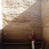
A report on site visits undertaken on the Karak Plateau during the 2018–2019 seasons.
Research Interests:
This study re-assesses and refines the use of crop carbon stable isotope values (Δ13C) to reconstruct past water availability. Triticum turgidum ssp. durum (durum wheat), Hordeum vulgare (six-row barley) and Sorghum bicolor (sorghum) were... more
This study re-assesses and refines the use of crop carbon stable isotope values (Δ13C) to reconstruct past water availability. Triticum turgidum ssp. durum (durum wheat), Hordeum vulgare (six-row barley) and Sorghum bicolor (sorghum) were experimentally grown at three crop research stations in Jordan for up to three years under five different irrigation regimes: 0% (rainfall only), 40%, 80%, 100% and 120% of the crops’ optimum water requirements. The results show a large variation in carbon stable isotope values of crops that received similar amounts of water, either as absolute water input or as percentage of crop requirements. We conclude that C3 crop carbon stable isotope composition should be assessed using a climate zone specific framework. In addition, we argue that interpretation should be done in terms of extremely high values showing an abundance of water versus low values indicating water stress, with values in between these extremes best interpreted in conjunction with other proxy evidence. Carbon stable isotope values of the C4 crop Sorghum were not found to be useful for the reconstruction of water availability.
Research Interests:
Droughts have had large impacts on past and present societies. High-resolution paleoclimate data are essential to place recent droughts in a meaningful historical context and to predict regional future changes with greater accuracy. Such... more
Droughts have had large impacts on past and present societies. High-resolution paleoclimate data are essential to place recent droughts in a meaningful historical context and to predict regional future changes with greater accuracy. Such records, however, are very scarce in the Middle East in general, and the Fertile Crescent in particular. Here we present a 2400 year long speleothem-based multiproxy record from Gejkar Cave in northern Iraq. Oxygen and carbon isotopes and magnesium are faithful recorders of effective moisture. The new Gejkar record not only shows that droughts in 1998–2000 and 2007–2010, which have been argued to be a contributing factor to Syrian civil war, were extreme compared to the current mean climate, but they were also superimposed on a long-term aridification trend that already started around or before 950 C.E. (Common Era). This long-term trend is not captured by tree ring records and climate models, emphasizing the importance of using various paleoclimate proxy data to evaluate and improve climate models and to correctly inform policy makers about future hydroclimatic changes in this drought-prone region.
Research Interests:
The Pre-Pottery Neolithic A (PPNA) period in Southwest Asia is essential for our understanding of the transition to sedentary, agricultural communities. Developments in architecture are key to understanding this transition, but many... more
The Pre-Pottery Neolithic A (PPNA) period in Southwest Asia is essential for our understanding of the transition to sedentary, agricultural communities. Developments in architecture are key to understanding this transition, but many aspects of PPNA architecture remain elusive, such as construction techniques, the selection of building materials, and the functional use of space. The primary aim of the research described within this contribution was to build a PPNA-like structure in order to answer questions about PPNA architecture in general, while specifically addressing issues raised by the excavation of structures at the site of WF16, Southern Jordan. The second aim was to display a ‘PPNA’ building to visitors in Wadi Faynan to enhance their understanding of the period. The experimental construction based on one of the WF16 structures showed that 1) required materials can be acquired locally; 2) a construction technique using mud layers as described in this paper was likely used; 3) flat, or very slightly dome-shaped, roofs are functional and can also be used as a solid working platform; 4) the WF16 small semi-subterranean buildings appear inappropriate for housing a nuclear family unit.
Research Interests:
Climate change is often cited as a major factor in social change. The so-called 8.2 ka event was one of the most pronounced and abrupt Holocene cold and arid events. The 9.2 ka event was similar, albeit of a smaller magnitude. Both events... more
Climate change is often cited as a major factor in social change. The so-called 8.2 ka event was one of the most pronounced and abrupt Holocene cold and arid events. The 9.2 ka event was similar, albeit of a smaller magnitude. Both events affected the Northern Hemisphere climate and caused cooling and aridification in Southwest Asia. Yet, the impacts of the 8.2 and 9.2 ka events on early farming communities in this region are not well understood. Current hypotheses for an effect of the 8.2 ka event vary from large-scale site abandonment and migration (including the Neolithisation of Europe) to continuation of occupation and local adaptation, while impacts of the 9.2 ka have not previously been systematically studied. In this paper, we present a thorough assessment of available, quality-checked radiocarbon (14C) dates for sites from Southwest Asia covering the time interval between 9500 and 7500 cal BP, which we interpret in combination with archaeological evidence. In this way, the synchronicity between changes observed in the archaeological record and the rapid climate events is tested. It is shown that there is no evidence for a simultaneous and widespread collapse, large-scale site abandonment, or migration at the time of the events. However, there are indications for local adaptation. We conclude that early farming communities were resilient to the abrupt, severe climate changes at 9250 and 8200 cal BP.
Research Interests:
Research Interests:
Reconstructing past water availability, both as rainfall and irrigation, is important to answer questions about the way society reacts to climate and its changes and the role of irrigation in the development of social complexity. Carbon... more
Reconstructing past water availability, both as rainfall and irrigation, is important to answer questions about the way society reacts to climate and its changes and the role of irrigation in the development of social complexity. Carbon stable isotope analysis of archaeobotanical remains is a potentially valuable method for reconstructing water availability. To further define the relationship between water availability and plant carbon isotope composition and to set up baseline values for the Southern Levant, grains of experimentally grown barley and sorghum were studied. The cereal crops were grown at three stations under five different irrigation regimes in Jordan. Results indicate that a positive but weak relationship exists between irrigation regime and total water input of barley grains, but no relationship was found for sorghum. The relationship for barley is site-specific and inter-annual variation was present at Deir ‘Alla, but not at Ramtha and Khirbet as-Samra.
Research Interests:
The Late (or Pottery) Neolithic is a key period in the archaeology of Jordan, as it is during this time that we find the first farming communities as we imagine them, with the distinction between ‘desert and sown’ and the use of dairy... more
The Late (or Pottery) Neolithic is a key period in the archaeology of Jordan, as it is during this time that we find the first farming communities as we imagine them, with the distinction between ‘desert and sown’ and the use of dairy products. However, the period remains understudied and is underrepresented in both ground and remote sensing surveys, and consequently in heritage databases. As has been shown in previous research (e.g. E. Banning) this probably does not reflect an actual absence of sites but rather their poor visibility and research biases. This poses a problem for protecting sites of this important period: to protect sites, we first need to know where they are.
Using publications and existing datasets, information on Late Neolithic sites in Jordan was collected and recorded in the freely available EAMENA database (www.eamenadatabase.arch.ox.ac.uk). Over a hundred sites with reliable evidence for Late Neolithic occupation have already been entered (April 2018). The dataset confirms that there is no lack of Late Neolithic sites, but they are often poorly visible with little evidence visible on the surface, and a research bias is clearly present. Remote sensing (satellite images and aerial photographs) is used to assess the condition of each site, including existing damage and potential threats. Finally, an analysis is made of site locations – while sites are hard to see on imagery or even the surface, we might be able to establish a pattern to their locations creating a predictive model potentially of value for other prehistoric periods.
Using publications and existing datasets, information on Late Neolithic sites in Jordan was collected and recorded in the freely available EAMENA database (www.eamenadatabase.arch.ox.ac.uk). Over a hundred sites with reliable evidence for Late Neolithic occupation have already been entered (April 2018). The dataset confirms that there is no lack of Late Neolithic sites, but they are often poorly visible with little evidence visible on the surface, and a research bias is clearly present. Remote sensing (satellite images and aerial photographs) is used to assess the condition of each site, including existing damage and potential threats. Finally, an analysis is made of site locations – while sites are hard to see on imagery or even the surface, we might be able to establish a pattern to their locations creating a predictive model potentially of value for other prehistoric periods.
Research Interests:
Research Interests:
The first ‘typical’ farming communities –small hamlets and villages with mixed farming, and possibly the distinction between ‘desert and sown’– came into existence during the Pottery Neolithic period (ca 7th-6th millennia BC). Due to a... more
The first ‘typical’ farming communities –small hamlets and villages with mixed farming, and possibly the distinction between ‘desert and sown’– came into existence during the Pottery Neolithic period (ca 7th-6th millennia BC). Due to a research bias, and especially their visibility, these generally small sites remain understudied in the Southern Levant. Sites are often located under metres of colluvium and only found through excavation (archaeological or otherwise, e.g. roadworks). Not only are they under-represented in the research record, but due to these factors, it is also very difficult to protect them.
Nonetheless, Pottery Neolithic sites have been recorded in surveys and excavations, and it is possible to collate these data into a standardised framework. Large datasets, such as the Endangered Archaeology in the Middle East and North Africa (EAMENA) database, can therefore help by giving an overview of what is known across the Southern Levant. Importantly, the remote sensing methodology developed by the EAMENA Project can also be used to assess the condition of these sites. Preliminary results for Jordan show that Pottery Neolithic sites have a more widespread distribution than previously thought, and that it is possible to predict their location (see Hitchings et al. 2013, Antiquity). By combining the EAMENA methodology, published data, and predictive models, we can start to identify areas of possible Pottery Neolithic sites and thus prioritise which areas to further research or protect when development takes place. This study shows how large datasets can help us study and protect neglected periods and sites.
Nonetheless, Pottery Neolithic sites have been recorded in surveys and excavations, and it is possible to collate these data into a standardised framework. Large datasets, such as the Endangered Archaeology in the Middle East and North Africa (EAMENA) database, can therefore help by giving an overview of what is known across the Southern Levant. Importantly, the remote sensing methodology developed by the EAMENA Project can also be used to assess the condition of these sites. Preliminary results for Jordan show that Pottery Neolithic sites have a more widespread distribution than previously thought, and that it is possible to predict their location (see Hitchings et al. 2013, Antiquity). By combining the EAMENA methodology, published data, and predictive models, we can start to identify areas of possible Pottery Neolithic sites and thus prioritise which areas to further research or protect when development takes place. This study shows how large datasets can help us study and protect neglected periods and sites.
Research Interests:
Research Interests:
Research Interests:
Around 8200 years ago, there was a rapid climate change: in less than a decade temperatures dropped considerably throughout the northern hemisphere, and aridity in the Near Eastern region likely increased. This so-called 8.2 ka event has... more
Around 8200 years ago, there was a rapid climate change: in less than a decade temperatures dropped considerably throughout the northern hemisphere, and aridity in the Near Eastern region likely increased. This so-called 8.2 ka event has been correlated to social changes as observed in the archaeological record, such as the spread of the Neolithic to Western Anatolia and into Europe, the abandonment of settlements, and changes where settlements continued. Around 9250 cal BP (ca 7200 BC), a similar event took place, albeit of a smaller magnitude.
This paper presents the results of a re-evaluation of currently available data to assess the impact of these two climatic events on Near Eastern early farming societies. As a first, but essential step is to ascertain synchronicity between climate and socio-economic change, the research focused on absolute dating evidence of al xx sites in use around the time of the climate events which have been radiocarbon dated. In addition, archaeological evidence was assessed. The results show that early farming societies were resilient to severe climate change events.
This paper presents the results of a re-evaluation of currently available data to assess the impact of these two climatic events on Near Eastern early farming societies. As a first, but essential step is to ascertain synchronicity between climate and socio-economic change, the research focused on absolute dating evidence of al xx sites in use around the time of the climate events which have been radiocarbon dated. In addition, archaeological evidence was assessed. The results show that early farming societies were resilient to severe climate change events.
Research Interests:
Research Interests:
Climate change has often been cited as a factor in socio-economic change as observed in the archaeological record. Around 8200 years ago (ca 6200 cal BC) the potentially most profound climatic event of the Holocene took place, which... more
Climate change has often been cited as a factor in socio-economic change as observed in the archaeological record. Around 8200 years ago (ca 6200 cal BC) the potentially most profound climatic event of the Holocene took place, which caused cooler and more arid conditions globally (the ‘8.2 ka event’). A similar arid event, although smaller in magnitude, took place around 9200 years ago. In the Near East, effects of the latter have not often been studied yet, but the 8.2 ka event has been linked to the abandonment of sites, the spread of the Neolithic, changes in settlement patterns, and local adaptation strategies, such as increased mobility and subsistence changes. However, claims that such developments were triggered by climatic change are in almost all cases disputed. Our aim was to re-assess current evidence for changes in societies at the time of both the 9.2 and 8.2 ka BP climatic events. As synchronicity is a key prerequisite (although not evidence) for a causal link between climate and socio-economic changes, we focus on dating evidence, using Bayesian modelling and GIS. In this paper we present results from throughout the Near East and show that early farming societies were more resilient in the face of severe climatic change than often thought.
Research Interests:
Past climate change is a much discussed topic in archaeology, especially in relation to potential effects on societies (with interpretations ranging from ‘collapse’ to ‘resilience’). As is widely acknowledged, before even starting to... more
Past climate change is a much discussed topic in archaeology, especially in relation to potential effects on societies (with interpretations ranging from ‘collapse’ to ‘resilience’). As is widely acknowledged, before even starting to debate causality, it is essential to establish if climatic events documented in natural climate archives and social and economic changes observed in the archaeological record are synchronous.
This paper focuses on the abrupt and short-lived 9.2 and 8.2 ka BP climatic events and their potential impact on Near Eastern societies. Both events are well-documented in climate archives and are, partly by the work of members of our team, precisely dated. The research presented here provides a critical re-evaluation of the archaeological data, foremost by a reappraisal of archaeological chronologies by quality checking radiocarbon dates and where possible applying Bayesian statistics. At the same time, GIS are used to better evaluate spatio-temporal changes. The results show variable reactions of Near Eastern societies living through climatic events.
This paper focuses on the abrupt and short-lived 9.2 and 8.2 ka BP climatic events and their potential impact on Near Eastern societies. Both events are well-documented in climate archives and are, partly by the work of members of our team, precisely dated. The research presented here provides a critical re-evaluation of the archaeological data, foremost by a reappraisal of archaeological chronologies by quality checking radiocarbon dates and where possible applying Bayesian statistics. At the same time, GIS are used to better evaluate spatio-temporal changes. The results show variable reactions of Near Eastern societies living through climatic events.
Research Interests:
Past water management practices, such as irrigation, have often been linked to socio-economic changes, but evidence for water management remains elusive. A promising technique in this respect is carbon stable isotope analysis of... more
Past water management practices, such as irrigation, have often been linked to socio-economic changes, but evidence for water management remains elusive. A promising technique in this respect is carbon stable isotope analysis of archaeobotanical remains. This method is based on the well-established correlation between water availability and plant isotopic composition.
The research presented in this paper focused first on improving the empirical basis of the method. Cereal crops were experimentally grown under different irrigation regimes at three locations in Jordan to test the effects of different amounts of water input in relation to other environmental variables. The suitability of charred archaeological grains for isotopic analyses was tested by charring and burial experiments. It was concluded that the method can be applied to archaeological samples for the reconstruction of past water availability, albeit with limitations.
This paper will present evidence for these conclusions and show how the method can be applied to archaeological samples. For the latter, the case studies of Tell es-Sa’idiyeh and Tell esh-Shuna, both in the Jordan Valley, are used; stable isotopic analyses of grains of these sites have given valuable insights into the development of water management in this region from the Chalcolithic to the Iron Age.
Knowledge of past climate and water management practices is essential for our understanding of past societies, especially in semi-arid regions such as the Near East. As plant carbon and nitrogen stable isotope ratios have been shown to be... more
Knowledge of past climate and water management practices is essential for our understanding of past societies, especially in semi-arid regions such as the Near East. As plant carbon and nitrogen stable isotope ratios have been shown to be affected by water inputs, measuring the stable isotopic composition of archaeological plant remains could be a potentially very valuable method for reconstructing water availability. Indeed, interesting applications have been conducted already. However, plant carbon and nitrogen stable isotope ratios are not only influenced by water inputs, but also by various other environmental factors. In addition, the effects of charring and diagenesis on the isotopic composition of archaeobotanical remains are not always well understood. Therefore, this research seeks to improve the method’s empirical basis and test the suitability of archaeological samples.
Experimentally grown cereals were used to assess the relationship between water availability, other environmental variables, and the crops’ stable isotopic composition. Wheat, barley and sorghum were grown at five different irrigation regimes at three different sites in Jordan for up to three years. Results indicate a relationship between water availability and carbon stable isotope ratios of wheat and barley grains, but one that is site-specific. No consistent relationship between nitrogen stable isotope ratios and water availability was found, but significant differences were present between sites.
Grains were experimentally charred, which appeared to alter plant isotope ratios in a few cases, but these can be corrected for. In addition, samples were buried at sites in the UK and Jordan and retrieved after up to two years. Preliminary results indicate that burial for this length of time does not alter isotopic ratios in any systematic manner, but unexplained exceptions were present.
This paper will thus argue that the method can be applied to archaeological samples for reconstruction of past water availability, but with limitations.
Carbon and nitrogen stable isotope ratios of archaeobotanical remains have been used to reconstruct past environment and agricultural practices. As the application of this method in archaeology is relatively recent, this research sought... more
Carbon and nitrogen stable isotope ratios of archaeobotanical remains have been used to reconstruct past environment and agricultural practices. As the application of this method in archaeology is relatively recent, this research sought to improve its empirical basis. Cereals were grown under different irrigation regimes; while this confirmed the correlation between water input and plant carbon isotopic composition, it also showed that the relationship is site specific. Experimentally charring and burial of grains indicated that the isotopic composition of archaeobotanical remains is not systematically affected by these processes. Finally, the method was applied to archaeological plant remains from Jordan.
Beidha is a Neolithic site in the south of Jordan. Excavated in the 1960s, much of its architecture is still visible. This, together with the site’s proximity to Petra, provides an excellent opportunity to present life in one of the first... more
Beidha is a Neolithic site in the south of Jordan. Excavated in the 1960s, much of its architecture is still visible. This, together with the site’s proximity to Petra, provides an excellent opportunity to present life in one of the first farming communities to the public. However, visitors often find it hard to interpret the archaeological remains in a meaningful way. The building of replica structures between 2001 and 2003 and the 2012 Beidha Visitor Interpretation Project have aimed at enhancing people’s understanding of the site. This paper will present the latter project and its findings.
Recently, excavations took place at the Pre-Pottery Neolithic A (PPNA) site of WF16 (11,600-10,200 BP) in the south of Jordan. These have uncovered a number of semi-subterranean elliptical structures consisting of pits lined with pisé... more
Recently, excavations took place at the Pre-Pottery Neolithic A (PPNA) site of WF16 (11,600-10,200 BP) in the south of Jordan. These have uncovered a number of
semi-subterranean elliptical structures consisting of pits lined with pisé walls. One structure had been burnt down and contained evidence regarding how their
roofs were made of wood, reeds and mud. Using this information a replica was built nearby to understand better how these buildings were constructed and used,
as well as to show the public what a PPNA structure would have looked like.