- University of Ostrava, Department of History, Graduate Studentadd
- noneedit
The landscapes of the Mohelno settlement microregion are mostly gently undulating, but also dissected by two deeply incised river valleys – the Oslava River valley in the north and the Jihlava River valley in the south. The western... more
The landscapes of the Mohelno settlement microregion are mostly gently undulating, but also dissected by two deeply incised river valleys – the Oslava River valley in the north and the Jihlava River valley in the south. The western boundary is formed by Zelený kopec (491 m above sea level, while the eastern boundary is marked by Biskoupský kopec (397.3 m above sea level) and Vodanský kopec (397.5 m above sea level). This microregion was settled at different intensities during the whole duration of prehistory. The ‘Boleniska’ elevation is located in the central part of the microregion and forms a strategic point – the entire microregion is visible from this elevation. This elevation comprise of an occupational palimpsest with intensive occupation during three different periods: at the beginning of the Upper Paleolithic (probably more than one techno-complex), the Late Neolithic (Lengyel culture) and at the end of the Eneolithic period (Bell Beaker culture). There is a high density of sites in this microregion from all three periods of interest. A similar settlement pattern (similar topography and cultural sequences) is known from other Moravian microregions. A preliminary testing of the site’s spatial distribution and a visibility analysis support the hypothesis indicating
Mohelno – ‘Boleniska’ as a central site within the entire microregion
only in the Paleolithic. The number of similar palimpsests composed of Paleolithic, Neolithic and Eneolithic sites is low within the entire microregion and the interpretation of this phenomenon must also take into consideration climatic factors, subsistence strategies, and socio-economic conditions in future research.
Research Interests: Archaeology, Prehistoric Archaeology, Settlement Patterns, Paleoenvironment, Neolithic Archaeology, and 14 moreBell Beakers (Archaeology), Lithic Technology, X-Ray Fluorescence (XRF) Spectroscopy, Neolithic Europe, Paleolithic Europe, Early Upper Paleolithic technocomplex (Archaeology), Middle to Upper Paleolithic Transition, Geophysical Survey, Archaeological Excavation, Eneolithic, Geoarchaeology and Paleoenvironmental Reconstructions, Lithic Raw Material Sourcing, Moravian Painted Ware Culture, and Lengyel Culture
The temporary lowering of the water level in Dalešice Reservoir for maintenance in the autumn of 2021 created an opportunity to conduct an archaeological investigation of the Kramolín hillfort – a site permanently flooded since the 1970s.... more
The temporary lowering of the water level in Dalešice Reservoir for maintenance in the autumn of 2021 created an opportunity to conduct an archaeological investigation of the Kramolín hillfort – a site permanently flooded since the 1970s. A small group of archaeologists reached the shore of Kramolín island by boat and performed the survey with metal detectors and GPS hand held devices. This survey produced a large collection of lithic artefacts, pottery sherds, and isolated metal artefacts from different prehistoric periods (including the Neolithic, Eneolithic, Bronze Age, Iron Age, Roman period and Early Middle Ages), which had already been identified during previous excavations. However, although the site was illegally surveyed with metal detectors earlier, several important artefacts were still found. In addition, the current state of the overlying sediment and its erosion was documented. The survey showed that the site is not yet exhausted and repeated survey in the case of the lowered water level can again provide more important information about this site.
Research Interests: Archaeology, Pottery (Archaeology), Neolithic Archaeology, Metal detector surveys (Archaeology), Neolithic Europe, and 15 moreUnderwater Archaeology, Iron Age, Late Bronze Age, Early Iron Age, Late Bronze Age, Eneolithic, Eneolithic in Central Europe, Hillforts and Enclosures, Hillforts and oppida, Arrowheads, Hallstatt and Latene period Middle Europe, Archaeology and Metal Detecting, Modern Age, Early Medieval Period, Roman Archaeology, and Archaeological Surface Survey
This historical-topographic work is based on archival sources, literature and Internet resources. It deals with the history of the village of Stará Ves nad Ondřejnicí. And from the general characteristics, through the historical... more
This historical-topographic work is based on archival sources, literature and Internet resources. It deals with the history of the village of Stará Ves nad Ondřejnicí. And from the general characteristics, through the historical development of the name and holders of the village, to additional information, which serves to fully understand the Stará Ves nad Ondřejnicí.
Research Interests:
In the first half of 2018, a rescue archaeological excavation was conducted at the site of Dolní Němčí – "Průhon" / "Kráčinky" in connection with the reconstruction of a field road. The site is located approximately 1.1 km southwest of... more
In the first half of 2018, a rescue archaeological excavation was conducted at the site of Dolní Němčí – "Průhon" / "Kráčinky" in connection with the reconstruction of a field road. The site is located approximately 1.1 km southwest of the centre of Dolní Němčí. It is a gentle slope descending from the north to the north-west, with an elevation ranging between 246 and 251 meters above sea level. Only 70 meters from the site, there is a stream called Okluky, which is intersected by the aforementioned field road. The rescue excavations allowed the documentation of three chronological horizons of human activities. The most recent horizon represents a system of relicts of sunken lanes from the late medieval ages and early modern periods. Only two sunken lanes extended into the excavated area, and due to time constraints, they were excavated through probe cuts. Two tracing probes were carried out in the sunken lane U1, and four tracing probes were conducted in the sunken lane U2. The documented profiles of all tracing probes provided a highly interesting stratigraphy, revealing a complex deposition environment associated with this type of archaeological feature. In addition to traces of worn tracks from wagons, which were evidently repeatedly used, a significant number of splash layers consisting of fine-grained sands or gravel facies were identified. Various forms of anthropogenic interventions, such as intentional soil or clay filling and detritus used for temporary repairs of the tracks following degradation by slope erosion or water, were also observed. In the probe 6 (sunken lane U2), a substantial accumulation of ceramic fragments and fill material was discovered in the north-eastern part of its base. In a few rare instances, archaeological artifacts such as ceramic shards, small pieces of bricks, and metal artifacts were found within the fillings of the tracing probes.
These artifacts can primarily be associated with wagons, travel, or personal belongings of individuals who used the roads (such as spikes, construction ironwork, buckles, coins, crosses, horseshoes etc.). Furthermore, in some cases evidence was documented the intrusion of prehistoric ceramic shards from a nearby settlement that were influenced by the construction of the new field road (particularly those belonging to the Linear Pottery culture). Alongside the presentation of the discovery situations and the obtained findings, this study aims to incorporate the identified relicts of sunken lanes into the context of the local network of communication corridors and their connection to regional and long distance tracks. The findings of metal parts, commonly identified as components of medieval wagons, constitutes an integral part of the excavation of the sunken lanes. Therefore, this study examines the shape and changes of these metal parts throughout the medieval ages and early modern periods, as well as their overall significance within these respective periods. The excavated local track leading from Dolní Němčí in the southwest direction from the village, where it connects to the regional road linking Hluk and Boršice u Blatnice, was traced on the available historical maps I, II, and III of military mapping, as well as through LiDAR slots. Considering the presence of two sacred objects along the track, it is possible to infer its greater importance within the region.
These artifacts can primarily be associated with wagons, travel, or personal belongings of individuals who used the roads (such as spikes, construction ironwork, buckles, coins, crosses, horseshoes etc.). Furthermore, in some cases evidence was documented the intrusion of prehistoric ceramic shards from a nearby settlement that were influenced by the construction of the new field road (particularly those belonging to the Linear Pottery culture). Alongside the presentation of the discovery situations and the obtained findings, this study aims to incorporate the identified relicts of sunken lanes into the context of the local network of communication corridors and their connection to regional and long distance tracks. The findings of metal parts, commonly identified as components of medieval wagons, constitutes an integral part of the excavation of the sunken lanes. Therefore, this study examines the shape and changes of these metal parts throughout the medieval ages and early modern periods, as well as their overall significance within these respective periods. The excavated local track leading from Dolní Němčí in the southwest direction from the village, where it connects to the regional road linking Hluk and Boršice u Blatnice, was traced on the available historical maps I, II, and III of military mapping, as well as through LiDAR slots. Considering the presence of two sacred objects along the track, it is possible to infer its greater importance within the region.
Research Interests: Archaeology, Historical Archaeology, Late Middle Ages, Medieval Archaeology, LiDAR, and 11 moreRescue Archaeology, Post-Medieval Archaeology, Early Modern Period, Human Activities, Metal Detectoring, Archaeology and Metal Detecting, Historical road networks, Old Aerial Photography , Historical Cartography, Old Maps Analysis, Archaeology of Early Modern Period, Medieval Travelling of an Entire Household., and Sunken Lane
Studie představuje výsledky dvou menších záchranných archeologických výzkumů z let 2018-2019, při kterých se podařilo prozkoumat několik sídlištních objektů platěnické kultury. Nově získané poznatky jsou zasazeny do mikroregionálního... more
Studie představuje výsledky dvou menších záchranných archeologických výzkumů z let 2018-2019, při kterých se podařilo prozkoumat několik sídlištních objektů platěnické kultury. Nově získané poznatky jsou zasazeny do mikroregionálního kontextu vývoje halštatského osídlení v povodí říčky Okluky. Představen je aktualizovaný stav poznání hustoty osídlení a sídelní strategie. Ve studii je rovněž prezentován prediktivní model, jehož testováním by mohly být v budoucnu identifikovány prozatím neznámé lokality.
Research Interests: Archaeology, Prehistoric Archaeology, Settlement Patterns, Rescue Archaeology, Settlement archaeology, and 11 moreIron Age, Late Hallstatt - Early LT period transition, Hallstatt, Predictive Modelling, Hallstatt period, Hallstatt and Latene Period, Hallstatt and Latene period Middle Europe, Hallstattzeit, Predictive Modeling, Hallstatt culture, and Platěnice culture
The paper informs about new finds from the Chřiby Mountains area obtained with the help of metal detectorists, which are functionally and chronologically classifiable as parts of a horse harness dated back to the Final Bronze Age or to... more
The paper informs about new finds from the Chřiby Mountains area obtained with the help of metal detectorists, which are functionally and chronologically classifiable as parts of a horse harness dated back to the Final Bronze Age or to the Early Iron Age, which in their design correspond to the material content of the ’Thraco-Cimmerian horizon‘, widely discussed in the past. Attention is paid to the technological-typological and chronological analysis of a part of a damaged bronze horse bit discovered in the cadastre of Roštín and a pair of cheek pieces from the cadastre of Břestek in the context of similar finds from Moravia. Through analyses of the spatial distribution of similar types of horse
harness elements in Central and Eastern Europe and analyses of elemental composition, the paper also contributes to the discussion of the validity of the ’Thraco-Cimmerian horizon‘ long-term associated
with the nomadic invasion at the end of the Bronze Age. An integral part of the study is also a polemic over the interpretative possibilities of the find situations and the contribution of amateur detectorism to the understanding of the development of human activities in the area of the Chřiby Mountains.
Research Interests: Archaeology, Prehistoric Archaeology, X-Ray Fluorescence (XRF) Spectroscopy, Metal detector surveys (Archaeology), Urnfield Culture, and 15 morePrehistory, Iron Age, portable XRF (PXRF) in Archaeology and Museum Science, Thracian Archaeology, Early Iron Age, Hallstatt, Cimmerians, Late Bronze Age, Horses, Scythian and other Eurasian Nomadic Horse Warrior Cultures, Ancient Horse Harnessing, Archaeology and Metal Detecting, Bronze Artefacts, Archeology, and Archaeology of Horse and Riders
Příspěvek prezentuje výsledky systematické detektorové prospekce v trati Buchlovice-"Dubový díl". Tato poloha byla vybrána jako modelový příklad jednoho z hlavních komunikačních koridorů v zalesněném prostředí Chřibů, u které byl sledován... more
Příspěvek prezentuje výsledky systematické detektorové prospekce v trati Buchlovice-"Dubový díl". Tato poloha byla vybrána jako modelový příklad jednoho z hlavních komunikačních koridorů v zalesněném prostředí Chřibů, u které byl sledován charakter i intenzita lidských aktivit a jejich proměna v čase se zaměřením na období raného středověku až novověku.
Research Interests: Archaeology, High Middle Ages, Medieval Archaeology, Metal detector surveys (Archaeology), Post-Medieval Archaeology, and 11 moreMedieval Military History, Human Activities, Metal Detectoring, Archaeology and Metal Detecting, Modern Age, Early Medieval Period, Historical road networks, Archaeology of Early Modern Period, Forest archaeology, Early Medieval Military Equipment, and Archaeology of Horse and Riders
In 2016, remains of a small bronze hoard were found in the central part of Chřiby Hills. The discovery was made during a systematic detection search at the edge of a forest road, therefore it cannot be excluded, that the depository found... more
In 2016, remains of a small bronze hoard were found in the central part of Chřiby Hills. The discovery was made during a systematic detection search at the edge of a forest road, therefore it cannot be excluded, that the depository found was not complete. In the base of a small hollow there were only five artefacts typologically consisting of three cast bronze
circles of rounded rhomboid profile and two perforated sleeves twisted into a tube. Both typological groups are, from the point of view of their functional usage, and based on up to date finds context from graves and depositories, associated most often with decoration of clothes, clothes accessories or horse harness. However, both are also found as parts of belt sets. Dating of the hoard Osvětimany 1 is problematic as none of the surviving artefacts are chronologically very sensitive and that is the reason the find can only be dated approximately to the age of Urnfield Culture, reaching to the Early Hallstatt Period. Important information was gained by observing the position of the depository in the land. The hoard was placed in the ground on a slope of a hillock situated at the entrance to
a narrowed valley, through which led an old path to the centre of Chřiby Hills, which further continued to South Moravian regions situated on the north west from them. The place is also at he the border of two different country biotopes (heights region opened into the Lower Moravia Valley and a hilly terrain of Chřiby Hills), and close to a confluence of two rivers. Whether the purpose of storing of the hoard was motivated by any ritual, symbolic or practical reasons, it is sure that the chosen place refers to the way the Chřiby Hills were perceived as a unique ritual-sacral land.
Research Interests: Archaeology, Bronze Age Europe (Archaeology), Metal detector surveys (Archaeology), Urnfield Culture, Prehistory, and 10 moreEarly Iron Age, Late Bronze Age, Early Iron Age, Hoards, Hoard finds, Late Bronze Age, Bronze Age metal hoards, Hoarding, Archaeology and Metal Detecting, Bronze Artefacts, and Iron Age Metal Hoards
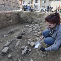
The salvage excavation of stone structure KSD was completed (an area of 27 m2) during subsequent campaigns in 2020 and 2021. Preliminary analysis of all excavated material was completed. Characteristics of the lithic industry and spatial... more
The salvage excavation of stone structure KSD was completed (an area of 27 m2) during subsequent campaigns in 2020 and 2021. Preliminary analysis of all excavated material was completed. Characteristics of the lithic industry and spatial patterning of artefacts and pavement are like previously excavated stone structures at the site (KSA, KSB, KSE). More detailed analyses of the KSD material will follow.
The structure consists of a paved area and an adjoining northeastern fold – this shape is like some of the other documented stone structures.
In a similar vein to the previously excavated structures, the raw material spectrum consists of prevailing local raw materials including rock crystal, quartz, plasma, smoky quartz, and Krumlovský les-type chert, supplemented by imported erratic flint and radiolarite. The technological spectrum is characterized by abundant splintered artefacts that were used as bipolar anvil cores for microlithic blanks (Fig. 9.6, 9.7). The prevailing tool types are endscrapers (however, some of the pieces were used as cores for carenoidal blanks) and burins. Fourteen microlithic tools were identified
(Sagaidak-Muralovka-type microliths), however, their number may increase when the collection of small finds is systematically studied under magnification.
Knapped stone artefacts were supplemented with heavy-duty implements made on coarser rocks including quartz, granulite, and amphibolite. Salvage excavation will continue in order to connect the individual trenches, i.e. in the areas between
individual structures. This will aid a detailed study of spatial distribution and testing hypotheses concerning contemporaneity / non- contemporaneity of the individual structures.