Juan Carlos López Quintana
Independent Researcher, Asociación de Arqueología AGIRI, Department Member
Research Interests:
Monografía pluridisciplinar de la cueva de Armintxe (Lekeitio, Bizkaia), que incluye el estudio del conjunto parietal magdaleniense (por C. González Sainz) y la evaluación arqueológica de los depósitos (por J.C. López Quintana).... more
Monografía pluridisciplinar de la cueva de Armintxe (Lekeitio, Bizkaia), que incluye el estudio del conjunto parietal magdaleniense (por C. González Sainz) y la evaluación arqueológica de los depósitos (por J.C. López Quintana). Coordinado por M. Unzueta Portilla.
Research Interests:
Research Interests:
A stratigraphic review of the Santimamiñe Cave strata was performed between 2004 and 2006 as part of an overall study, conservation and dissemination programme of this archaeological site. The stratigraphic survey conducted affected the... more
A stratigraphic review of the Santimamiñe Cave strata was performed between 2004 and 2006 as part of an overall study, conservation and dissemination programme of this archaeological site. The stratigraphic survey conducted affected the innermost section of the antechamber and provided a 6 metre deep sequence with 27 stratigraphic units, divided into four sets based on geoclimatic and palaetnologic criteria. The lower set accommodates two levels with palaeontological content (Arb-o and Arg-o), developed during MIS 3-MIS 2, and dating from c. 27000 to 20000 BP. Above sits the flood level, a powerful layer of sterile silt and clay, deposited in all likelihood, during GI-2. The upper-meso level is characterised by the significant presence of cryoclastic processes, referring to Csn-Camr, Slnc and Arcp levels, formed during the Late Glacial Period (GS-2, GI-1d and GS-1). These three phases of climate worsening saw the first human occupation of the cave of Santimamiñe: late lower Magdalenian, late upper Magdalenian and Azilian, between c. 14700 and 10000 BP. Finally, the top level was deposited during the first half of the Holocene, with Mesolithic (very mild), Neolithic and Chalcolithic-Bronze occupation, between c. 7600 and 3700 BP. The present study rules out, at least in the area assessed, the existence of human occupation from the early and middle Upper Palaeolithic.
Research Interests:
Research Interests:
El nº 7 de la revista Illunzar recoge el contenido de las XIX JORNADAS DE ARQUEOLOGÍA DE URDAIBAI (“El Conjunto Monumental de Katillotxu: una mirada al Megalitismo cantábrico”), celebradas los días 26 y 27 de noviembre de 2009 en el... more
El nº 7 de la revista Illunzar recoge el contenido de las XIX JORNADAS DE ARQUEOLOGÍA DE URDAIBAI (“El Conjunto Monumental de Katillotxu: una mirada al Megalitismo cantábrico”), celebradas los días 26 y 27 de noviembre de 2009 en el Centro de la Biodiversidad de Euskadi (Busturia). A través de un Seminario Científico, se presentaron los resultados del estudio pluridisciplinar del monumento megalítico de Katillotxu V y del proyecto de conservación y difusión del Conjunto Monumental de Katillotxu. El Seminario se estructuró en tres partes: a) una serie de 3 ponencias sobre el Megalitismo cantábrico y el Arte Megalítico del Norte de la Península Ibérica; b) una presentación preliminar de la excavación arqueológica y estudio pluridisciplinar del dolmen de Katillotxu V; y c) dos comunicaciones, desde el ámbito de la Administración, sobre protección legal y gestión del Patrimonio Megalítico de Bizkaia.
Research Interests:
Presentamos el nº 6 de la revista Illunzar, volumen monográfico sobre el área de Portuzarra (Gernika-Lumo, Bizkaia), presunta ubicación del puerto medieval de la villa de Gernika. El estudio que publicamos corresponde al proyecto de... more
Presentamos el nº 6 de la revista Illunzar, volumen monográfico sobre el área de Portuzarra (Gernika-Lumo, Bizkaia), presunta ubicación del puerto medieval de la villa de Gernika. El estudio que publicamos corresponde al proyecto de evaluación arqueológica del trazado de obra del Vial Urbano Perimetral en Errenteria. Es, por tanto, una memoria resultada de un programa de “arqueología de intervención”.
Research Interests:
El nº 5 de la revista Illunzar incluye siete artículos sobre Arqueología de Urdaibai y entorno próximo: desde los primeros testimonios de ocupación humana en el Musteriense, localizados en la cueva de Atxagakoa (Forua), hasta un... more
El nº 5 de la revista Illunzar incluye siete artículos sobre Arqueología de Urdaibai y entorno próximo: desde los primeros testimonios de ocupación humana en el Musteriense, localizados en la cueva de Atxagakoa (Forua), hasta un interesante hallazgo carlista en la cueva de Abittaga (Amoroto), con un estudio histórico de contextualización. Se presenta un artículo sobre el Inventario de Patrimonio Cultural de Urdaibai (I); dos estudios sobre la cueva de Kobeaga II (referentes a la microfauna y a un diente humano); una revisión de los estudios de la Edad del Hierro en Urdaibai; y un trabajo sobre las alfarerías postmedievales en Bizkaia, elaborado a raíz del examen de un lote cerámico localizado en superficie en la isla de Izaro (Bermeo).
Research Interests:
Research Interests:
In about the last third of the fifth millennium in calibrated years BC, the territory of Biscay underwent a series of changes that would be decisive for the development of human groups and their environment and landscape. The occupation... more
In about the last third of the fifth millennium in calibrated years BC, the territory of Biscay underwent a series of changes that would be decisive for the development of human groups and their environment and landscape. The occupation of caves became less common until it played a secondary role, while the most fertile land was used to grow new exotic plants and crops (barley and emmer wheat). Among the animal resources that were consumed, domestic species, especially ovicaprines, also from external origins, became predominant in the place of the native wild prey. This picture has been obtained through the study of cave sites like Kobaederra, Pico Ramos, Lumentxa and Santimamiñe. However, the truly stable settlements, which must have been in the open-air and where the daily activities of these incipient farmers in the eastern Cantabrian region would have been recorded, are still missing.
In the mortuary world, in the late fifth millennium cal BC, the last individual burials in caves in the Meso-Neolithic tradition (Lumentxa) coincided with the introduction of a new funerary ritual in which the dead shared the same mortuary space, in pantheons that were more or less monumental in scale and built by the human group. The territory of Biscay displayed an organisation and demarcation of the land through these stone tombs, of which over a hundred have reached the present time. If we take a look at Biscay in recent prehistory, the place of the dead can be visualised quite clearly, but the land of the living is unknown and indistinct, especially the stable habitation sites.
In the mortuary world, in the late fifth millennium cal BC, the last individual burials in caves in the Meso-Neolithic tradition (Lumentxa) coincided with the introduction of a new funerary ritual in which the dead shared the same mortuary space, in pantheons that were more or less monumental in scale and built by the human group. The territory of Biscay displayed an organisation and demarcation of the land through these stone tombs, of which over a hundred have reached the present time. If we take a look at Biscay in recent prehistory, the place of the dead can be visualised quite clearly, but the land of the living is unknown and indistinct, especially the stable habitation sites.
Research Interests:
Research Interests:
After the discovery of a recent Magdalenian parietal ensemble in Armintxe Cave in 2016, fieldwork was carried out in 2017 and 2018 for an archaeological assessment of the site. In 2017, test pits were excavated in the deposits inside the... more
After the discovery of a recent Magdalenian parietal ensemble in Armintxe Cave in 2016, fieldwork was carried out in 2017 and 2018 for an archaeological assessment of the site. In 2017, test pits were excavated in the deposits inside the entrance hall and in the intermediate passage. In 2018, a study was made of the stratigraphy in the floors of the high-level passage in Sector 1, which contains most of the graphic motifs in Armintxe. The results indicated that the cave was rarely frequented by humans, who utilised the site mainly as a ceremonial and artistic centre. In the entrance hall, palaeontological and taphonomic evidence suggests that it was used as a spotted hyena (Crocuta crocuta) den during a cold phase dated by radiocarbon to 33,275-32,245 cal. BP (Beta-574975).
Research Interests:
Research Interests:
Research Interests:
Research Interests:
Research Interests:
L
Research Interests:
Research Interests:
Research Interests:
Research Interests:
Research Interests:
Research Interests:
Research Interests:
Research Interests:
Research Interests:
Research Interests:
Research Interests:
The excavation of the megalithic complex of the Pena Oviedo, pretends to be the beginning of a larger study that approaches the megalithic phenomenon in the global River basins of the Deva and Nansa rivers. The total lack of knowledge of... more
The excavation of the megalithic complex of the Pena Oviedo, pretends to be the beginning of a larger study that approaches the megalithic phenomenon in the global River basins of the Deva and Nansa rivers. The total lack of knowledge of the megalithic phenomenon, but not even of its existence in these mountain valleys of western Cantabria, requires a study that reveals its characteristics and relations with neighboring areas.
Research Interests:
The Basque population inhabits the Franco-Cantabrian region in southwest Europe where Palaeolithic human groups took refuge during the Last Glacial Maximum. Basques have been an isolated population, largely considered as one of the most... more
The Basque population inhabits the Franco-Cantabrian region in southwest Europe where Palaeolithic human groups took refuge during the Last Glacial Maximum. Basques have been an isolated population, largely considered as one of the most ancient European populations and it is possible that they maintained some pre-Neolithic genetic characteristics. This work shows the results of mitochondrial DNA analysis of seven ancient human remains from the Cave of Santimamiñe in the Basque Country dated from Mesolithic to the Late Roman period. In addition, we compared these data with those obtained from a modern sample of Basque population, 158 individuals that nowadays inhabits next to the cave. The results support the hypothesis that Iberians might have been less affected by the Neolithic mitochondrial lineages carried from the Near East than populations of Central Europe and revealed the unexpected presence of prehistoric maternal lineages such as U5a2a and U3a in the Basque region. Comparis...
Research Interests:
Research Interests:
Research Interests:
Research Interests:
A series of stratigraphic evidence, documented recently and supported by palaeoenvironmental and radiometric analysis, reveals an episode of abandonment in the human occupation of caves in the first part of the Greenland Interstadial 1... more
A series of stratigraphic evidence, documented recently and supported by palaeoenvironmental and radiometric analysis, reveals an episode of abandonment in the human occupation of caves in the first part of the Greenland Interstadial 1 complex. At the caves of Santimamiñe, Erralla and Berroberria, the disoccupation phase appears in the sequence between lower-middle Magdalenian and upper Magdalenian levels. Similarly, Santa Catalina and Morgotako Koba contain upper-final Magdalenian stratigraphy (of very different importance) over layers of barren sand and clay, which are very likely to correspond to the same palaeoenvironmental event.
In sedimentological terms, they are stratigraphic units with a clear predominance of fine components (nearly always with percentages of over 90%), varying between clay and sand. The examples that have been studied display at their top erosive episodes, with concave surfaces in which hollows and channel bottoms can be identified. Archaeologically, they are barren (although in some cases very sporadic occupations may have occurred). The cause of the absence of human occupation would be the high humidity levels, and it is possible that the cave entrance chambers became flooded.
This abandonment phase appears to be dated between ca. 18,000-17,000 and 15,000-14,000 cal BP. In the particular case of Santimamiñe, after a human occupation specialised in the hunting and processing of red deer, between 18,000 and 17,2000 cal BP (Csn-Camr unit), the cave was abandoned and was not reoccupied with any intensity until 15,300-14,800 cal BP, when human groups with more diversified subsistence strategies arrived (Slnc unit).
The chrono-stratigraphic, environmental and archaeological context of this episode of disoccupation can be associated with the Cantabrian VI phase in M. Hoyos’ periodization of the late Pleistocene (Bølling in pollen chronology) and its position within the GI-1 interstadial complex is discussed in the more general framework from the analysis of marine and ice cores.
Research Interests:
The Cave of Santimamiñe is located in the eastern part of the Cantabrian region in the Oka River basin between the town of Guernica and the Bay of Biscay coast. Paleolithic cave art was discovered in it in 1916 and archeological... more
The Cave of Santimamiñe is located in the eastern part of the Cantabrian region in the Oka River basin between the town of Guernica and the Bay of Biscay coast. Paleolithic cave art was discovered in it in 1916 and archeological excavations were conducted between 1918-1926 by Aranzadi, Barandiarán and Eguren and in 1960-1962 by Barandiarán. The stratigraphic restudy of Santimamiñe (2004-2006) obtained a 6-m deep sequence, with 27 stratigraphic units that contain evidence of 7 phases of human occupation of the cave, between the latter part of the Tardiglacial and the mid-Holocene. The Magdalenian sequence includes an occupation by humans who conducted specialized red deer hunting during the late Cantabrian Lower Magdalenian (Level Csn), a period of abandonment of the cave (Level Balm), a new period of ephemeral human occupation within a layer attesting to stratigraphic disturbances (Level Almp), a more intensive, longer occupation in which Santimamiñe became the main locus of human settlement in the Oka River basin in the Upper-Final Magdalenian (Level Slnc). The Magdalenian sequence is capped by an Azilian level (Arcp), which, like Slnc, attests a more diversified subsistence economy including red deer, ibex, roe deer, fish (salmonids) and other marine resources. Despite the cave’s proximity to excellent flysch flint sources, there are consistently small amounts of flints from SW France (Chalosse) and the trans-Cordilleran interior of the Basque Country, attesting to indirect or direct human contacts/social relations. The sequence is dated by six AMS assays on bone collagen ranging from 14,670 to 10,100 uncal. BP. This article also includes an overview of the recent, thorough restudy of the rich Magdalenian (probably Upper-Final) cave art of Santimamiñe, one of the key sites of this period in the Basque Region. (traslation: L.G. Straus)
Research Interests:
After the discovery of very deteriorated and faded red cave paintings in Ondaro Cave (Nabarniz, Biscay) in 2014, an archaeological trial excavation was carried out at the foot of the decorated wall. The fill, with a thickness of 40cm, has... more
After the discovery of very deteriorated and faded red cave paintings in Ondaro Cave (Nabarniz, Biscay) in 2014, an archaeological trial excavation was carried out at the foot of the decorated wall. The fill, with a thickness of 40cm, has been divided into two stratigraphic groups: the lower group (Units Sla and Slab-o) did not yield any evidence of human activity, but a discreet paleontological ensemble dominated by remains of hyena (Crocuta crocuta); 2) the upper group (Units Slac, H-Clsn and Lsac) displayed evidence of human occupation in all its units and in Unit H-Clsn, archaeological remains dated to 27,500 ± 120 BP may well correspond to the time when the cave art was painted.
Research Interests:
The Neolithic in the River Oka drainage basin (Urdaibai, Bizkaia): state of the art and proposals for future study The Neolithic record in the River Oka drainage basin has been enriched considerably by research programmes in the last two... more
The Neolithic in the River Oka drainage basin (Urdaibai, Bizkaia): state of the art and proposals for future study
The Neolithic record in the River Oka drainage basin has been enriched considerably by research programmes in the last two decades. The open-air settlement of Pareko Landa, the caves of Kobaederra, Santimamiñe, Kobeaga II and Morgota, and the dolmen of Katillotxu I have been excavated in this time, generally with a similar methodological approach, providing a varied series of data on subsistence strategies of human groups and climate and vegetation changes in the Oka basin in the Middle Holocene. Between ca. 5300-4700 BP, cave occupations, open-air settlements and megalithic tombs were all in use in the Urdaibai area, as Neolithic farmers developed new ways of organising the territory. The current state of knowledge is described, noting the main issues in the subject and proposing lines of research.
The Neolithic record in the River Oka drainage basin has been enriched considerably by research programmes in the last two decades. The open-air settlement of Pareko Landa, the caves of Kobaederra, Santimamiñe, Kobeaga II and Morgota, and the dolmen of Katillotxu I have been excavated in this time, generally with a similar methodological approach, providing a varied series of data on subsistence strategies of human groups and climate and vegetation changes in the Oka basin in the Middle Holocene. Between ca. 5300-4700 BP, cave occupations, open-air settlements and megalithic tombs were all in use in the Urdaibai area, as Neolithic farmers developed new ways of organising the territory. The current state of knowledge is described, noting the main issues in the subject and proposing lines of research.
Research Interests:
The archaeological excavation at Santimamiñe by José Miguel de Barandiaran: an exemplary early twentieth century excavation The teaming up of T. de Aranzadi, J. M. de Barandiaran and E. de Eguren marked the start of systematic prehistoric... more
The archaeological excavation at Santimamiñe by José Miguel de Barandiaran: an exemplary early twentieth century excavation
The teaming up of T. de Aranzadi, J. M. de Barandiaran and E. de Eguren marked the start of systematic prehistoric research in the Basque Country. After the exploration of the dolmen sites of Aralar, Aitzgorri, Ataun-Borunda, etc. from 1917 to 1921, Santimamiñe Cave would be the first prehistoric sequence they excavated and studied, from 1918 to 1926. Their study, well-organised thematically, was published in 1925, 1931 and 1935. After his return from exile, J. M. de Barandiaran carried out a second series of excavations in the cave (1960-1962).
Bearing in mind the general conditions at the time as regards knowledge and availability of technical and analytical resources, added to the complexity of the prehistoric deposit at Santimamiñe itself, these three researchers’ work must undoubtedly be considered exemplary. The methodology they used, their conclusions and diagnoses, the excavations reports, etc. are reviewed here and a stratigraphic correlation between the sequence they described and the results of the twenty-first century fieldwork is proposed.
Santimamiñe is an emblematic site in Basque Prehistory. It contains a large ensemble of Magdalenian cave art and a long sequence of prehistoric human occupation. At the historiographic level, it represents the first major sequence studied by Aranzadi, Barandiaran and Eguren, and one of the main documentary sources for the first approach to the scientific construction of Basque Prehistory.
Research Interests:
(Vertebrates from the Dolmen of Errekatxuetako Atxa (Holocene) (Zeanuri, Bizkaia): During the excavation of the Dolmen of Errekatxuetako Atxa in 2006 several vertebrate remains were found. Mammals are represented in the site by one... more
(Vertebrates from the Dolmen of Errekatxuetako Atxa (Holocene) (Zeanuri, Bizkaia): During the excavation of the Dolmen of Errekatxuetako Atxa in 2006 several vertebrate remains were found. Mammals are represented in the site by one lagomorph, six rodents, three insectivores, three artiodactyls, two carnivores and one primate, the reptilians by one saurian and one ophidian and the amphibians by one urodele and three anuran. The amphibians and reptilies are the most abundant microvertebrate.which is not usual in other Holocene archeological and Paleontological sites of the Cantabrian Basin. This could result from the presence of a wetland near the studied site. The vertebrate assemblage indicates a humid temperate climate quite similar to that occurring in the area at present day. Palabras clave: Vertebrados, Holoceno, Dolmen, Cornisa Cantábrica, Parque Natural de Gorbeia.
Research Interests:
Ancient mitochondrial lineages support the prehistoric maternal root of Basques in Northern Iberian Peninsula The Basque population inhabits the Franco-Cantabrian region in southwest Europe where Palaeolithic human groups took refuge... more
Ancient mitochondrial lineages support the prehistoric maternal root of Basques in Northern Iberian Peninsula
The Basque population inhabits the Franco-Cantabrian region in southwest Europe where Palaeolithic human groups took refuge during the Last Glacial Maximum. Basques have been an isolated population, largely considered as one of the most ancient European populations and it is possible that they maintained some pre-Neolithic genetic characteristics. This work shows the results of mitochondrial DNA analysis of seven ancient human remains from the Cave of Santimamiñe in the Basque Country dated from Mesolithic to the Late Roman period. In addition, we compared these data with those obtained from a modern sample of Basque population, 158 individuals that nowadays inhabits next to the cave. The results support the hypothesis that Iberians might have been less affected by the Neolithic mitochondrial lineages carried from the Near East than populations of Central Europe and revealed the unexpected presence of prehistoric maternal lineages such as U5a2a and U3a in the Basque region. Comparison between ancient and current population samples upholds the hypothesis of continuity of the maternal lineages in the area of the Franco-Cantabrian region.
The Basque population inhabits the Franco-Cantabrian region in southwest Europe where Palaeolithic human groups took refuge during the Last Glacial Maximum. Basques have been an isolated population, largely considered as one of the most ancient European populations and it is possible that they maintained some pre-Neolithic genetic characteristics. This work shows the results of mitochondrial DNA analysis of seven ancient human remains from the Cave of Santimamiñe in the Basque Country dated from Mesolithic to the Late Roman period. In addition, we compared these data with those obtained from a modern sample of Basque population, 158 individuals that nowadays inhabits next to the cave. The results support the hypothesis that Iberians might have been less affected by the Neolithic mitochondrial lineages carried from the Near East than populations of Central Europe and revealed the unexpected presence of prehistoric maternal lineages such as U5a2a and U3a in the Basque region. Comparison between ancient and current population samples upholds the hypothesis of continuity of the maternal lineages in the area of the Franco-Cantabrian region.
Research Interests:
This work described the characteristics in which a small polished axe, made of sillimanite-fibrolite, was discovered, within the context of Cave Morgota archaeological deposit (Kortezubi, Bizkaia). This object has been mineralogical and... more
This work described the characteristics in which a small polished axe, made of sillimanite-fibrolite, was discovered, within the context of
Cave Morgota archaeological deposit (Kortezubi, Bizkaia). This object has been mineralogical and chemically characterized by using different
archaeometric techniques. Hypotheses about its possible geological and geographical origin are proposed.
Cave Morgota archaeological deposit (Kortezubi, Bizkaia). This object has been mineralogical and chemically characterized by using different
archaeometric techniques. Hypotheses about its possible geological and geographical origin are proposed.
Research Interests:
The presence of Atlantic themes in the most Mediterranean area of the North of the Iberian Peninsulaserves as an invitation to reflect on the validity of the traditional boundaries which defined the Pyrenees as the border between the... more
The presence of Atlantic themes in the most Mediterranean area of the North of the Iberian Peninsulaserves as an invitation to reflect on the validity of the traditional boundaries which defined the Pyrenees as the border between the megalithic worlds of the Atlantic and the Mediterranean. Indeed, the territorialextension of the Iberian megalithic art coincides with that of the French megalithic art of which some of thebest examples can be found in the South-east. The metal weapons represented in Vizcaya and Navarra drawattention to the strong symbolic facet of an area traditionally considered as marginal, and coincide with themetal resources of these rich environments of great potential for herding and agriculture. The engravedPalmela point of KTV is the first of its kind identified in the South of Europe. Its integration within amegalithic construction confirms the long course of development of these tombs which underwent in themid-thirdmillenniumcalBConeoftheirgreatestmomentsofinflexion,atatimecontemporarytotheuseof the Beaker assemblage.
Research Interests:
This paper discusses the potential and limits of wood charcoal analysis in dolmen sites. For that purpose, we present the case of the study of plant macroremains from Mendigana dolmen in Gorbeia. The sampling strategy has considered all... more
This paper discusses the potential and limits of wood charcoal analysis in dolmen sites. For that purpose, we present the case of the study of plant macroremains from Mendigana dolmen in Gorbeia. The sampling strategy has considered all the areas in which there has been an archaeological intervention (chamber, frontal stratigraphic section, sondage) and there have been analyses of both, samples collected in situ and flotation processed samples. Other plant macroremains are very few, mostly fragments of hazelnut pericarp, a poorly represented taxon among wood charcoal. The main component of carbonized wood samples, are deciduous oaks with an important presence of bushy taxons of leguminous and heathers. Birch and beech are also significant taxons in some samples, while ash, hazel, alder and willow are present in low percentages. Thus, wood charcoal suggests the presence of several plant communities in the surroundings of the dolmen: a mixed oakwood, a beechwood and open formations of heathers. The diversity of results in the analyzed contexts will allow us to discuss some questions about the method and the potential of wood charcoal analysis as independent contextual evidence and to understand the dynamic of formation, use and alteration of the archaeological structures.
Research Interests:
An approach to the study of menhirs requires some preliminary questions, first a terminological one and, consequently, one about the conceptualization of the phenomenon and in relation to this, about the chronocultural and functional... more
An approach to the study of menhirs requires some preliminary questions, first a terminological one and, consequently, one about the conceptualization of the phenomenon and in relation to this, about the chronocultural and functional contexts of evidence. The theme could be reduced to three groups of questions: is this terminology adequate for the manifestations of the area? What monuments should we consider Menhires ?, and what human groups are responsible for their construction and what role did these structures play within their Ideological system?
Research Interests:
Research Interests:
Archaeobotanical analyses of pollen and plant macroremains as seeds and wood charcoal have been carried out at the Estuary of Urdaibai (Bizkaia). They show a wooded environment developed from the Early Holocene with presence of mixed... more
Archaeobotanical analyses of pollen and plant macroremains as seeds and wood charcoal have been carried out at the Estuary of Urdaibai (Bizkaia). They show a wooded environment developed from the Early Holocene with presence of mixed decidious forests dominated by Quercus Robur and Corylus. Farming practices are present from at least 5500 BP.
Research Interests:
Research Interests:
Palabras-clave: Arte parietal. Descubrimiento. Magdaleniense superior. Paleolítico. Pintura. Premagdaleniense.
Research Interests:
Morgota Cave (Morgotako Koba), 440m to the WNW of Santimamiñe Cave, was discovered in 1982, when a number of archaeological and palaeontological remains were found. On 23 May 2014, ADES Caving Club spotted a series of red paintings and... more
Morgota Cave (Morgotako Koba), 440m to the WNW of Santimamiñe Cave, was discovered in 1982, when a number of archaeological and palaeontological remains were found. On 23 May 2014, ADES Caving Club spotted a series of red paintings and stains in the cave entrance chamber. These were later confirmed as Palaeolithic graphic representations by specialist archaeologists. Two seasons of archaeological research in the cave have been carried out in 2014 and 2015, and two stratigraphic soundings have been excavated. This work has identified and dated by C14-AMS a Palaeolithic archaeological deposit probably associated with the production of the parietal ensemble.
Research Interests:
The anthropological record found in Cueva de Santimamiñe (old excavations and modern fieldwork) is apparently scanty, dispersed and disordered. The mortuary use of the cave has been interpreted as a series of very sporadic inhumations... more
The anthropological record found in Cueva de Santimamiñe (old excavations and modern fieldwork) is apparently scanty, dispersed and disordered. The mortuary use of the cave has been interpreted as a series of very sporadic inhumations during the Chalcolithic and Bronze Age. The modern reappraisal of the deposit has confirmed this hypothesis as it has revealed a long discontinuous mortuary sequence, with some significant uses, such as a burial in the late sixth millennium cal BC.
Research Interests:
Research Interests:
Research Interests:
The Katillotxu I Dolmen (Mundaka, Biscay) belongs to the Megalithic Station of Sollube within the Oka River basin in eastern Cantabria. C14-AMS dating has established the construction and main usage phase of KT-I during the Neolithic. The... more
The Katillotxu I Dolmen (Mundaka, Biscay) belongs to the Megalithic Station of Sollube within the Oka River basin in eastern Cantabria. C14-AMS dating has established the construction and main usage phase of KT-I during the Neolithic. The occasional use of the burial chamber during the Bronze Age has also been detected. This article presents an overview of the archaeological context and the results of the petrological analysis of flint and ornamental items, providing new data related to the study of complex abiotic resource exchange networks during the Neolithic.
Research Interests:
The mountainous massif of Gorbeia is located in the extreme east of the Cantabrian region, and acts as a division between the waters of the Atlantic and Mediterranean. It is situated between the valleys of the Rivers Arratia and... more
The mountainous massif of Gorbeia is located in the extreme east of the Cantabrian region, and acts as a division between the waters of the Atlantic and Mediterranean. It is situated between the valleys of the Rivers Arratia and Nervión-Altube, forming part of the provinces of Bizkaia and Araba (Basque Country). The characteristic landscapes of this geographic unit are made up of the valleys formed at the head of the Rivers Arratia and Nervión-Altube, and the areas of mountain where, from a lower to higher altitude, stratifications of deciduous forest and alpine grass appear. The highest peak is located on the Gorbeia Mountain at an altitude of 1,482m.
The Megalithic Period of Gorbeia incorporates 16 dolmens, 7 menhirs and 3 cists. The largest part of this group is found in the territory of Bizkaia, with 3 dolmens (Ganbidea, Oketa and Luberri) and 3 menhirs (Arlobi, Pagozarreta and El Gizon) found within Araba. The elements situated in Bizkaia were judged to be Heritage sites, within the category of Historical Monuments, by DECREE 25/2009 of 3rd February of the Department of Culture of the Basque Government.
Within the framework of the investigation project “La transición al Neolítico en el Cantábrico oriental: hábitat y megalitos en las áreas de Urdaibai y Gorbeia”, we have begun systematic works of archaeological excavation and multi-disciplinary studies of the following sites and/ or archaeological groups in Gorbeia:
1) The Archaeological Site of Larreder (Areatza-Bilaro, Bizkaia). The works began in the area of Larreder (2001-2003), located at an altitude of 736m, within the north-eastern sector of the Gorbeia Natural Park. The Mendigana dolmen (2001) and the open air Epipalaeolithic settlement of Sustrigi (2002-2003) were investigated, situated 200m to the SE of the Mendigana site.
2) The Archaeological Site of Arimekorta (Zeanuri, Bizkaia). In 2006 an intensive archaeological compaign was undertaken in the Arimekorta site, located in the eastern part of the Gorbeia Natural Park, at an altitude of 915m. This site includes a Megalithic monument, the Errekatxuetako Atxa dolmen; a series of 4 sites in the open air, Errekatxueta 1, 2, 3 and 4, with proofs of chalcolithic inhabitation in the areas immediately surrounding the dolmen; the area of outcrops and secondary deposits of Urgonian silex of Arimekorta-Aldaminape; and the cave of Legoaldai 1, with indications of a sepulchral site.
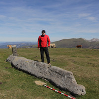
3) The Kurtzegan Menhir (Orozko, Bizkaia). In 2008 a series of stratigraphic surveys was carried out in the Kurtzegan menhir, located in the north-western sector of the Gorbeia Natural Park, at an altitude of 849m. These works permitted the identification of the implantation trench of the menhir, a block of Albian sandstone of 5.40m of length, which then itself secured some data relating to the relative chronology of the site.
In the current work, we reflect on the patterns of spatial distribution of the sites concerned, and propose a sequence of sepulchral use for the dolmens and cists. Complementing this, we offer testimonies (concerning symbolic components and access to determined prestigious heritage sites) which refute the idea of a marginal and backward facing Megalithism in the eastern Cantabrian region. In complete contrast we argue for a Megalithism that was well connected with the social universe, funerals and symbolic of the Iberian Peninsula and Southern Europe.
The Megalithic Period of Gorbeia incorporates 16 dolmens, 7 menhirs and 3 cists. The largest part of this group is found in the territory of Bizkaia, with 3 dolmens (Ganbidea, Oketa and Luberri) and 3 menhirs (Arlobi, Pagozarreta and El Gizon) found within Araba. The elements situated in Bizkaia were judged to be Heritage sites, within the category of Historical Monuments, by DECREE 25/2009 of 3rd February of the Department of Culture of the Basque Government.
Within the framework of the investigation project “La transición al Neolítico en el Cantábrico oriental: hábitat y megalitos en las áreas de Urdaibai y Gorbeia”, we have begun systematic works of archaeological excavation and multi-disciplinary studies of the following sites and/ or archaeological groups in Gorbeia:
1) The Archaeological Site of Larreder (Areatza-Bilaro, Bizkaia). The works began in the area of Larreder (2001-2003), located at an altitude of 736m, within the north-eastern sector of the Gorbeia Natural Park. The Mendigana dolmen (2001) and the open air Epipalaeolithic settlement of Sustrigi (2002-2003) were investigated, situated 200m to the SE of the Mendigana site.
2) The Archaeological Site of Arimekorta (Zeanuri, Bizkaia). In 2006 an intensive archaeological compaign was undertaken in the Arimekorta site, located in the eastern part of the Gorbeia Natural Park, at an altitude of 915m. This site includes a Megalithic monument, the Errekatxuetako Atxa dolmen; a series of 4 sites in the open air, Errekatxueta 1, 2, 3 and 4, with proofs of chalcolithic inhabitation in the areas immediately surrounding the dolmen; the area of outcrops and secondary deposits of Urgonian silex of Arimekorta-Aldaminape; and the cave of Legoaldai 1, with indications of a sepulchral site.
3) The Kurtzegan Menhir (Orozko, Bizkaia). In 2008 a series of stratigraphic surveys was carried out in the Kurtzegan menhir, located in the north-western sector of the Gorbeia Natural Park, at an altitude of 849m. These works permitted the identification of the implantation trench of the menhir, a block of Albian sandstone of 5.40m of length, which then itself secured some data relating to the relative chronology of the site.
In the current work, we reflect on the patterns of spatial distribution of the sites concerned, and propose a sequence of sepulchral use for the dolmens and cists. Complementing this, we offer testimonies (concerning symbolic components and access to determined prestigious heritage sites) which refute the idea of a marginal and backward facing Megalithism in the eastern Cantabrian region. In complete contrast we argue for a Megalithism that was well connected with the social universe, funerals and symbolic of the Iberian Peninsula and Southern Europe.
Research Interests:
The presence of Atlantic themes in the most Mediterranean area of the North of the Iberian Peninsula serves as an invitation to reflect on the validity of the traditional boundaries which defined the Pyrenees as the border between the... more
The presence of Atlantic themes in the most Mediterranean area of the North of the Iberian Peninsula serves as an invitation to reflect on the validity of the traditional boundaries which defined the Pyrenees as the border between the megalithic worlds of the Atlantic and the Mediterranean. Indeed, the territorial extension of the Iberian megalithic art coincides with that of the French megalithic art of which some of the best examples can be found in the South-east.
The metal weapons represented in Vizcaya and Navarra draw attention to the strong symbolic facet of an area traditionally considered as marginal, and coincide with the metal resources of these rich environments of great potential for herding and agriculture. The engraved Palmela point of KTV is the first of its kind identified in the South of Europe. Its integration within a megalithic construction confirms the long course of development of these tombs which underwent in the mid-third millennium cal BC one of their greatest moments of inflexion, at a time contemporary to the use of the Beaker assemblage.
The metal weapons represented in Vizcaya and Navarra draw attention to the strong symbolic facet of an area traditionally considered as marginal, and coincide with the metal resources of these rich environments of great potential for herding and agriculture. The engraved Palmela point of KTV is the first of its kind identified in the South of Europe. Its integration within a megalithic construction confirms the long course of development of these tombs which underwent in the mid-third millennium cal BC one of their greatest moments of inflexion, at a time contemporary to the use of the Beaker assemblage.
Research Interests:
Research Interests:
Research Interests:
Research Interests:
Research Interests:
Research Interests:
Research Interests:
Research Interests:
Research Interests:
Research Interests:
Research Interests:
Katillotxu V monumentuak 12 metroko diametroa eta 0,75 metroko altuera ditu. Oin plano laukizuzen luzexkadun hilobi ganbara du, 2,20 metro luze eta 0,80 m zabal dena, Hego-ekialdera orientatua. Katillotxu V-eko arkitekturak alde... more
Katillotxu V monumentuak 12 metroko diametroa eta 0,75 metroko altuera ditu. Oin plano laukizuzen luzexkadun hilobi ganbara du, 2,20 metro luze eta 0,80 m zabal dena, Hego-ekialdera orientatua. Katillotxu V-eko arkitekturak alde nabarmenak ditu Katillotxu I-ekoarekin alderatuz gero. Katillotxu V-eko bolumena eta monumentaltasuna lurrezko nukleoa jarriz lortu zen, eta nukleo horren erdian sartu zuten hilobi ganbara. Monumentuaren azalera ingurua hare-harrizko harkoskoz egindako geruza batez estali zen, eta horrela lortu zuten harrizko monumentuaren irudia, askoz lan gutxiago eginez. Tumuluaren ingurua, ezkata gisa, posizio azpi-bertikalean, inbrikatutako harkoskoen bitartez antolatu da. Kanpoaldeko perimetroa, bertikalean, peristalito gisa, kokatutako harkoskoen eraztun ez jarraituak mugatzen du. Arquitectura El monumento megalítico de Katillotxu V posee unas medidas de 12 metros de diámetro por 0,75 m de altura. Alberga una cámara sepulcral de planta rectangular alargada, de 2,20 m de longitud por 0,80 m de anchura, orientada al Sureste. La arquitectura de Katillotxu V presenta diferencias notables con respecto a Katillotxu I. El volumen y monumentalidad de Katillotxu V se consigue mediante la colocación de un núcleo de tierra, en el centro del cual se inserta la cámara funeraria. La parte superfi cial del monumento se recubre con una coraza de bloques de arenisca, mostrando la imagen de un monumento de piedra, conseguido con una menor inversión de trabajo. El área tumular se organiza por medio de bloques imbricados a modo de escamas, en posición subvertical, delimitados en su perímetro exterior por un anillo discontinuo de bloques colocados en posición vertical, a modo de peristalito.
Research Interests:
Research Interests:
Research Interests:
Research Interests:
Research Interests:
Research Interests:
Research Interests:
The presence of Atlantic themes in the most Mediterranean area of the North of the Iberian Peninsula serves as an invitation to reflect on the validity of the traditional boundaries which defined the Pyrenees as www.em-consulte.com... more
The presence of Atlantic themes in the most Mediterranean area of the North of the Iberian Peninsula
serves as an invitation to reflect on the validity of the traditional boundaries which defined the Pyrenees as
www.em-consulte.com
Disponible en ligne sur www.sciencedirect.com
doi:10.1016/j.anthro.2009.09.010
Author's personal copy
The border between the megalithic worlds of the Atlantic and the Mediterranean. Indeed, the territorial extension of the Iberian megalithic art coincides with that of the French megalithic art of which some of the
best examples can be found in the South-east. The metal weapons represented in Vizcaya and Navarra draw attention to the strong symbolic facet of an area traditionally considered as marginal, and coincide with the metal resources of these rich environments of great potential for herding and agriculture. The engraved Palmela point of KTV is the first of its kind identified in the South of Europe. Its integration within a megalithic construction confirms the long course of development of these tombs which underwent in the mid-third millennium cal BC one of their greatest moments of inflexion, at a time contemporary to the use ofthe Beaker assemblage.