Location via proxy:   [ UP ]  
[Report a bug]   [Manage cookies]                
SlideShare a Scribd company logo
International Research Journal of Engineering and Technology (IRJET) e-ISSN: 2395-0056
Volume: 06 Issue: 03 | Mar 2019 www.irjet.net p-ISSN: 2395-0072
© 2019, IRJET | Impact Factor value: 7.211 | ISO 9001:2008 Certified Journal | Page 7638
Use Geotechnical to Analyze Agricultural Use Changes to Support
Urban Planning Policies
Shadi Z. M. Kuhail
skouhail@ucas.edu.ps
Master of Geography and GIS
Coordinator of GIS Specialization
Lecturer in Information Technology Department
University College of Applied Sciences - Gaza. Palestine
------------------------------------------------------------------------------------------------------------------------------------------
Abstract:The study aimed at analyzing satellite data to
track the change in agricultural use in Gaza governorates by
using geographic information systems and remote sensing
techniques, in addition to determining the land plots that are
considered the most appropriate in directing urbanization
away from the waste of agricultural lands. The study also
showed an overview of information systems Geographic and
Remote Sensing As an optimal technical technique used in
analysis, the study showed that the use of remote sensing
technology cannot be dispensedthroughtheanalysisofspatial
visualization to calculate the area of agricultural land in
ancient times Recently, the study showed that the use of
cartographic modeling to arrive at the identification of
appropriate vouchers for agricultural activities is more
efficient than the methods used in local institutions.
Key Words: Geotechnical-Agricultural-GIS-Remote Sensing-
Farmland- Model Builder.
1.INTRODUCTION
Urban growth is one of the most important human
phenomena, and the rapid growth of urban populations has
become a major danger. The population of cities with more
than 10,000 people jumped from 700 million in 1950 to 2.3
billion in 1990. According to UN estimates, Cities of this
category to about 5.5 billion people in 2025.(1)
This rapid increase of the population will inevitablyleadtoa
rapid expansion of the urban mass and may be at the
expense of agricultural land. The study of land use is one of
the subjects that require high accuracyandgreatpotential in
producing detailed maps and detailed databases to include
the development of chronological analysis of maps. Of the
use of remote sensing techniques because it is capable of
handling a huge amount of space images and conducting
many computerized statistics and processes.
1.1 Subject of study
The governorates of Gaza witnessed a significant urban
expansion at the expense of agriculturallandanddidnotstop
the urban growth as long as there are needsofthepopulation
of the urban cluster so the subject of the study in answer to
the following questions:
1. Is the expansion of the urban block has a negative impact
on agricultural land?
2. Can maps be provided showing the distribution of current
and future agricultural land?
3. How geotechnical techniques are used to analyze satellite
data?
1.2 Objectives
1. The use of GIS technology and remote sensing in the
analysis of satellite data
2. Study of the change in the area of agricultural land from
1975 to 2018 using remote sensing.
3. Expected calculation of agricultural land in 2030.
2. Method of analysis
Remotesensingprogramsvaryamongthemselvesintermsof
accuracy in the analysis of satellite images, but there are
software gaps vary from one program to another, but Eardas
Imagingthemostaccurateandcomprehensiveprograms,and
the process of building the database in the programs of the
sensor pass through many stages, combining,merging,initial
processing and interpretation.
The spatial data collection for the periods 1975-1985-1995,
2005-2015-2018, according toUTM-WGS84ZONE36N, was
done by four readings per period to meet the need of the
sequential analysis of the average seasons of the year
because there are plants grown in the summer and another
in the winter, A visual rating of each period was completed
and then collected and a network map of the analytical
medium was produced.
Fig -1: Stages of data analysis and satellite images
International Research Journal of Engineering and Technology (IRJET) e-ISSN: 2395-0056
Volume: 06 Issue: 03 | Mar 2019 www.irjet.net p-ISSN: 2395-0072
© 2019, IRJET | Impact Factor value: 7.211 | ISO 9001:2008 Certified Journal | Page 7639
The reflected radiation from agricultural land is influenced
by several factors, the most important of which is the
roughness and softness of the vegetation cover and the
materials it contains. The radiation reflected from the green
trees is different from the radiation reflection of dry trees.
Therefore, it is possible to estimate the area of agricultural
land and tree density (2).
Analysis of chlorophyll in the water, which reflectsthecycle
of amphibian plants that affect the nature of the reflected
radiation. Water containing large quantities of suspended
sediments reflects visible wave radiation more than pure
water. Here in the Gaza Strip, In satellite images accurately
when applying the average analytical approach to
classifications by seasons of the year.
Table-1: Results of analysis of satellite images of Farmland
Governorate Gaza km2
year
RafahKhanYounesMiddleGazaNorth
12.0133.3622.3829.4130.161975
11.1830.6723.0826.0320.721985
11.1528.4121.7624.1615.381995
9.3223.8418.2219.1811.222005
17.5728.0819.2013.379.512015
17.3129.1313.3713.109.662018
The table shows that there is a decline in the area of
agricultural land from 1975 to 2018 for urban use. It is also
evident that there is an increase in agricultural land in Khan
Younis and Rafah from 2005 to 2015 due to the withdrawal
of the Israeli occupation from the settlements in the Gaza
Strip. A slight increase in the agricultural area from 2015 to
2018 at the level of most governorates in view of the
encouragement of the Ministry of Agriculture on agriculture
and the identification of crops for self-sufficiency.(3).
Chart -1: Development of the agricultural land area
3. data analysis
The results of the analysis are used for theyears 1975-1985-
1995-2005-2015 using the output data produced by the
Markov chain analysis within the IDRISI environment. An
application model was implemented for the first half of
2015. This model uses the results of the years precedingthis
model. Which shows the expectation and change in the
expansion of the urban mass, the standard KAPA model is
used to test the validity of this data. If the reliability ratio is
more than 70% here we acknowledge its validity. If the
KAPA model is a measurement of less than 70% correct.(4)
Fig -2: classification and analysis of satellite images
In terms of the data of this research, the measurement of the
Kappa IDRISI model using a validated tool was given a kaba
level of 0.9314, a kappa for the information used 0.8229, a
kappa for the cell level of 0.8325 and a kappa for the class
accuracy of 0.8951, all above 0.7. This gives a high analytical
index. Forecasts for 2030.(5)
Table-2: Classification of agricultural use by seasons / km2
Year January April July October average
1975 144.25 137.56 122.32 105.26 127.35
1985 118.85 116.56 112.21 98.99 111.66
1995 113.86 110.97 98.59 79.99 100.87
2005 91.26 89.19 82.69 63.99 81.79
2018 101.86 100.19 80.26 68.71 87.75
International Research Journal of Engineering and Technology (IRJET) e-ISSN: 2395-0056
Volume: 06 Issue: 03 | Mar 2019 www.irjet.net p-ISSN: 2395-0072
© 2019, IRJET | Impact Factor value: 7.211 | ISO 9001:2008 Certified Journal | Page 7640
4. Predict
Table-3: Expected results 2030 / km2
Governorate Gaza 2030
RafahKhanYounesMiddleGazaNorthType
26.1743.4937.8134.5036.60Urban
9.1513.471.455.462.68agricultural
The above table shows that there are expectations of a
further decline in agricultural land according to the
projections of 2030. It is also noted that there are provinces
where agricultural lands may be exposed to extinction, such
as the
northern and central governorates.(6)
5. Use cartographic modeling to reduce waste of
agricultural land.
One of the basic requirements for building the cartographic
model is the formulation of criteria or the conditions
necessary to evaluate the land for the future development
process, which ensures the fulfillment of the needs and the
maintenance of the standard of land ownership. The use of
GIS technology here in determining the areas that can be
employed as new residential areas and according to special
criteria in the region.(7)
In this study, criteria were carefully formulated after
reviewing previous studies, field visits, comparison with
international standards, conducting a series of personal
interviews and working with correspondents.(8)
Fig -3: Results of applying the study criteria
5.1: Building Model Builder.
After building the hierarchical model and defining the
criteria, types, levels and degree of weight, the cartographic
model was built in the ArcGIS and through the structural
model, which is based on the simplification of complex
problems and the overlap of the data and their spatial and
descriptive relationships. Therefore, this model is
formulated to simplify the problem and formulate the
method of solving it through So-calledgraphical layoutofthe
stages of work.(9)
Fig -4: Modeling and charting
5.2: Analysis proposed sites
After setting the criteria for deliberate guidance for the
agricultural and urban growth of the Gaza governorates and
after applying the weights, the process concluded to devise
the appropriate sites as follows.(10)
Fig -5: Map relevance 2030
International Research Journal of Engineering and Technology (IRJET) e-ISSN: 2395-0056
Volume: 06 Issue: 03 | Mar 2019 www.irjet.net p-ISSN: 2395-0072
© 2019, IRJET | Impact Factor value: 7.211 | ISO 9001:2008 Certified Journal | Page 7641
6. CONCLUSIONS
6.1.Gaza Strip is a rapidly growing population, one of the
highest in the world, and this is the main reasonfortherapid
decline of agricultural land.
6.2.The study showed that thereisa verystrongrelationship
between the expansion of the urban mass and the steady
increase in the number of population in the Gaza
Governorates. This is the main determinant of the planned
agricultural planning.
6.3.The study succeeded in preparing a detailed study to
show the evolution and change in the spatial distribution of
land use maps since 1975.
6.4.The study showed the ability of GIS and remote sensing
technology to study the evolution of agricultural and urban
land area through the production of accurate maps.
6.5.The use of analysis according to the Markov Applied
Mathematical Chain and the confirmation of results
according to this Kaba accuracy index gives accurate results
for relying on the results of the research in government
decision making.
6.6.The use of cartographic modeling to determine the
future agricultural and urban growth areas is more efficient
than the methods used in local institutions, optimizing the
use of resources, achieving the highest returns and
minimizing land losses.
6.7.The process of relying on the distribution of the
questionnaire to the planning and GIS specialists is one of
the best ways to obtain the weights of the planning
standards accurately.
7. Recommendations study
7.1. Adopt a strategy to increase the absorptive capacity of
existing urban centers by encouraging the vertical
expansion of buildings.
7.2. Focus on public awareness to realize the importance
of commitment to urban planning and conservation of
agricultural land according to the provisions of the
structural plans and interest in popular participation in
the preparation of future plans.
7.3. Use of geographic information systems and remote
sensing in all local institutions because it has proved
successful in the preparation of spatial databases
REFERENCES:
1. United Nations (World Urbanization Prospects) New
York 2014.
2. Ir Yannick Curnel (Basic principles of remote sensing)
Dec 2014 - Walloon Agricultural Research Centre (CRA-W)-
Agriculture and natural environment Department-p21.
3. Palestinian Sector Plan (Urban Development Sector)
2010-2020 -p11
4. Canada Centre for Remote Sensing(Fundamentals
of Remote Sensing)2016
5..Werle D (Radar Remote Sensing - A Training Manual) .
(1988 and 1992), 193p, 75 35mm slides, Dendron Resource
Surveys Ltd, Ottawa, Ontario, Canada, ISBN 0- 9693733-0-9
6. Oliver, C. & S. Quegan (Understandingsyntheticaperture
radar images) 1998, 479 p., Artech House, Norwood, MA,
USA, ISBN 089006850X
7. Sohaib abu jaeab (Future Urban Development in Khan
Yunis Governorate in light of the conservation of
environmental resources using GIS.RS)2012. Master of
Islamic University in Gaza Palestine .p199.
8. Ministry of Works and Human Settlement(Spatial
Planning Standards)June 2017.p9.
9. Isri Company (ModelBuilder - Creating Tools Tutorial)
Copyright © 1995-2010 Esri. All rights reserved.
10. Shadi Kuhail (Impact of the Urban Growth On The
Land Ownership In Gaza Governorates, Using GIS and
Remote Sensing Technology)2013. Master of Islamic
University in Gaza Palestine .p190.

Recommended for you

Applications of gis
Applications of gisApplications of gis
Applications of gis

This document discusses the various applications of geographic information systems (GIS). It begins by introducing GIS and its capabilities, such as data input, management, analysis and modeling. It then examines 10 specific applications of GIS: 1) geological mapping, 2) mining and mineral exploration, 3) groundwater exploration, 4) environmental analysis, 5) disaster management, 6) transportation systems, 7) demographic analysis, 8) agricultural development, 9) forestry, and 10) tourism. For each application, it provides details on how GIS is used to analyze spatial data, facilitate decision making, and support planning and management activities.

Casos de uso do FME no IBGE
Casos de uso do FME no IBGECasos de uso do FME no IBGE
Casos de uso do FME no IBGE

The document summarizes two cases of using FME at the Brazilian Institute of Geography and Statistics (IBGE). Case 1 describes how FME was used to develop a process for automatically generating topographic maps from vector data. Case 2 discusses how FME was used to: 1) create a geoid undulation model from IBGE data, 2) calculate geoid heights and convert ellipsoid heights to orthometric heights for over 16 million points, and 3) develop processes to analyze and compare digital elevation models using different vertical datums. The document indicates FME helped address challenges like processing large datasets more efficiently.

Applications of RS and GIS in Urban Planning by Rakshith m murthy
Applications of RS and GIS in Urban Planning by Rakshith m murthyApplications of RS and GIS in Urban Planning by Rakshith m murthy
Applications of RS and GIS in Urban Planning by Rakshith m murthy

This document discusses the application of remote sensing (RS) and geographical information systems (GIS) in urban planning. It explains that RS allows for the collection of spatial, spectral and temporal data about areas in an accurate and cost-effective manner, while GIS stores and analyzes geographic data in layers. The document then provides several examples of how RS and GIS have been used in urban planning, including analyzing urban sprawl in Bengaluru, mapping land use changes in Mysuru over time, assessing water demand and supply in Nairobi, and monitoring archaeological sites for encroachment using satellite imagery. It concludes that RS and GIS are necessary technologies for urban planning authorities to efficiently respond to issues faced by rapidly urbanizing

More Related Content

What's hot

[IJET-V1I5P1] Authors :Ahmed Mohamed Abushnafa, R. K. Pandeyb, Deepak Lalc
[IJET-V1I5P1] Authors :Ahmed  Mohamed  Abushnafa, R. K. Pandeyb, Deepak Lalc[IJET-V1I5P1] Authors :Ahmed  Mohamed  Abushnafa, R. K. Pandeyb, Deepak Lalc
[IJET-V1I5P1] Authors :Ahmed Mohamed Abushnafa, R. K. Pandeyb, Deepak Lalc
IJET - International Journal of Engineering and Techniques
 
Geographic information system – an introduction
Geographic information system – an introductionGeographic information system – an introduction
GIS in land administration
GIS in land administrationGIS in land administration
GIS in land administration
anjali s
 
Applications of gis
Applications of gisApplications of gis
Applications of gis
Pramoda Raj
 
Casos de uso do FME no IBGE
Casos de uso do FME no IBGECasos de uso do FME no IBGE
Casos de uso do FME no IBGE
Inovação GIS - Tecnologia da Informação
 
Applications of RS and GIS in Urban Planning by Rakshith m murthy
Applications of RS and GIS in Urban Planning by Rakshith m murthyApplications of RS and GIS in Urban Planning by Rakshith m murthy
Applications of RS and GIS in Urban Planning by Rakshith m murthy
s0l0m0n7
 
Urban planing & gis
Urban planing & gisUrban planing & gis
Urban planing & gis
Shanake Dissanayake
 
MIS 08 Geographical Information System
MIS 08  Geographical Information SystemMIS 08  Geographical Information System
MIS 08 Geographical Information System
Tushar B Kute
 
GIS for traffic management system
GIS for traffic management systemGIS for traffic management system
GIS for traffic management system
Sourabh Jain
 
Applications of remote sensing and gis
Applications of remote sensing and gisApplications of remote sensing and gis
Applications of remote sensing and gis
Muralikrishnan143
 
Applications of gis
Applications of gisApplications of gis
Applications of gis
Pramoda Raj
 
Things to know about geospatial technology
Things to know about geospatial technologyThings to know about geospatial technology
Things to know about geospatial technology
NI BT
 
GIS in Civil Engineering
GIS in Civil EngineeringGIS in Civil Engineering
GIS in Civil Engineering
abhishek chougule
 
Geographical information system in transportation planning
Geographical information system in transportation planning Geographical information system in transportation planning
Geographical information system in transportation planning
shayiqRashid
 
Geodatabase with GIS & RS
Geodatabase with GIS & RSGeodatabase with GIS & RS
Geodatabase with GIS & RS
Mohammed_82
 
Application of gis for forest study
Application of gis for forest studyApplication of gis for forest study
Application of gis for forest study
meengistu adane
 
IEEE SIGHT Bombay section webinar talk on GIS & Remote Sensing-Introduction t...
IEEE SIGHT Bombay section webinar talk on GIS & Remote Sensing-Introduction t...IEEE SIGHT Bombay section webinar talk on GIS & Remote Sensing-Introduction t...
IEEE SIGHT Bombay section webinar talk on GIS & Remote Sensing-Introduction t...
AdityaAllamraju1
 
Principles of GIS unit 1
Principles of GIS unit 1Principles of GIS unit 1
Principles of GIS unit 1
SanjanaKhemka1
 
Basics to gis concepts unit i
Basics to gis concepts unit iBasics to gis concepts unit i
Basics to gis concepts unit i
H.M College of science and technology, Manjeri
 
Gis applications & Implement
Gis applications & ImplementGis applications & Implement
Gis applications & Implement
RAQIBSTELEGRAPH
 

What's hot (20)

[IJET-V1I5P1] Authors :Ahmed Mohamed Abushnafa, R. K. Pandeyb, Deepak Lalc
[IJET-V1I5P1] Authors :Ahmed  Mohamed  Abushnafa, R. K. Pandeyb, Deepak Lalc[IJET-V1I5P1] Authors :Ahmed  Mohamed  Abushnafa, R. K. Pandeyb, Deepak Lalc
[IJET-V1I5P1] Authors :Ahmed Mohamed Abushnafa, R. K. Pandeyb, Deepak Lalc
 
Geographic information system – an introduction
Geographic information system – an introductionGeographic information system – an introduction
Geographic information system – an introduction
 
GIS in land administration
GIS in land administrationGIS in land administration
GIS in land administration
 
Applications of gis
Applications of gisApplications of gis
Applications of gis
 
Casos de uso do FME no IBGE
Casos de uso do FME no IBGECasos de uso do FME no IBGE
Casos de uso do FME no IBGE
 
Applications of RS and GIS in Urban Planning by Rakshith m murthy
Applications of RS and GIS in Urban Planning by Rakshith m murthyApplications of RS and GIS in Urban Planning by Rakshith m murthy
Applications of RS and GIS in Urban Planning by Rakshith m murthy
 
Urban planing & gis
Urban planing & gisUrban planing & gis
Urban planing & gis
 
MIS 08 Geographical Information System
MIS 08  Geographical Information SystemMIS 08  Geographical Information System
MIS 08 Geographical Information System
 
GIS for traffic management system
GIS for traffic management systemGIS for traffic management system
GIS for traffic management system
 
Applications of remote sensing and gis
Applications of remote sensing and gisApplications of remote sensing and gis
Applications of remote sensing and gis
 
Applications of gis
Applications of gisApplications of gis
Applications of gis
 
Things to know about geospatial technology
Things to know about geospatial technologyThings to know about geospatial technology
Things to know about geospatial technology
 
GIS in Civil Engineering
GIS in Civil EngineeringGIS in Civil Engineering
GIS in Civil Engineering
 
Geographical information system in transportation planning
Geographical information system in transportation planning Geographical information system in transportation planning
Geographical information system in transportation planning
 
Geodatabase with GIS & RS
Geodatabase with GIS & RSGeodatabase with GIS & RS
Geodatabase with GIS & RS
 
Application of gis for forest study
Application of gis for forest studyApplication of gis for forest study
Application of gis for forest study
 
IEEE SIGHT Bombay section webinar talk on GIS & Remote Sensing-Introduction t...
IEEE SIGHT Bombay section webinar talk on GIS & Remote Sensing-Introduction t...IEEE SIGHT Bombay section webinar talk on GIS & Remote Sensing-Introduction t...
IEEE SIGHT Bombay section webinar talk on GIS & Remote Sensing-Introduction t...
 
Principles of GIS unit 1
Principles of GIS unit 1Principles of GIS unit 1
Principles of GIS unit 1
 
Basics to gis concepts unit i
Basics to gis concepts unit iBasics to gis concepts unit i
Basics to gis concepts unit i
 
Gis applications & Implement
Gis applications & ImplementGis applications & Implement
Gis applications & Implement
 

Similar to IRJET- Use Geotechnical to Analyze Agricultural use Changes to Support Urban Planning Policies

Spatial-Temporal Analysis of Land Use: Coimbatore Corporation, Tamil Nadu
Spatial-Temporal Analysis of Land Use: Coimbatore Corporation, Tamil NaduSpatial-Temporal Analysis of Land Use: Coimbatore Corporation, Tamil Nadu
Spatial-Temporal Analysis of Land Use: Coimbatore Corporation, Tamil Nadu
IRJET Journal
 
IRJET- Land Use & Land Cover Change Detection using G.I.S. & Remote Sensing
IRJET-  	  Land Use & Land Cover Change Detection using G.I.S. & Remote SensingIRJET-  	  Land Use & Land Cover Change Detection using G.I.S. & Remote Sensing
IRJET- Land Use & Land Cover Change Detection using G.I.S. & Remote Sensing
IRJET Journal
 
IRJET- Watershed Delineation of Kumbhoj Nala Basin by using QGIS
IRJET-  	  Watershed Delineation of Kumbhoj Nala Basin by using QGISIRJET-  	  Watershed Delineation of Kumbhoj Nala Basin by using QGIS
IRJET- Watershed Delineation of Kumbhoj Nala Basin by using QGIS
IRJET Journal
 
Accuracy Assessment of Land Use/Land Cover Classification using multi tempora...
Accuracy Assessment of Land Use/Land Cover Classification using multi tempora...Accuracy Assessment of Land Use/Land Cover Classification using multi tempora...
Accuracy Assessment of Land Use/Land Cover Classification using multi tempora...
IRJET Journal
 
Comparison among Height Observation of GPS, Total Station and Level and their...
Comparison among Height Observation of GPS, Total Station and Level and their...Comparison among Height Observation of GPS, Total Station and Level and their...
Comparison among Height Observation of GPS, Total Station and Level and their...
IRJET Journal
 
Integration of GIS Based Survey procedure to update Road Network Geo-Database...
Integration of GIS Based Survey procedure to update Road Network Geo-Database...Integration of GIS Based Survey procedure to update Road Network Geo-Database...
Integration of GIS Based Survey procedure to update Road Network Geo-Database...
Soumik Chakraborty
 
IRJET - Normalized Difference Vegetation Index (NDVI) based Land Cover Cl...
IRJET -  	  Normalized Difference Vegetation Index (NDVI) based Land Cover Cl...IRJET -  	  Normalized Difference Vegetation Index (NDVI) based Land Cover Cl...
IRJET - Normalized Difference Vegetation Index (NDVI) based Land Cover Cl...
IRJET Journal
 
IRJET- Evaluation of Traffic Congestion using Comparative Land use Pattern-A ...
IRJET- Evaluation of Traffic Congestion using Comparative Land use Pattern-A ...IRJET- Evaluation of Traffic Congestion using Comparative Land use Pattern-A ...
IRJET- Evaluation of Traffic Congestion using Comparative Land use Pattern-A ...
IRJET Journal
 
IRJET- Investigation of Changes in Water, Residential, Bare Land and Green Ar...
IRJET- Investigation of Changes in Water, Residential, Bare Land and Green Ar...IRJET- Investigation of Changes in Water, Residential, Bare Land and Green Ar...
IRJET- Investigation of Changes in Water, Residential, Bare Land and Green Ar...
IRJET Journal
 
IRJET- Bus Route Optimization in Jyothi Engineering College using ARC- GIS
IRJET- Bus Route Optimization in Jyothi Engineering College using ARC- GISIRJET- Bus Route Optimization in Jyothi Engineering College using ARC- GIS
IRJET- Bus Route Optimization in Jyothi Engineering College using ARC- GIS
IRJET Journal
 
The use of GIS for the development of the A9 dual-carriageway
The use of GIS for the development of the A9 dual-carriagewayThe use of GIS for the development of the A9 dual-carriageway
The use of GIS for the development of the A9 dual-carriageway
Peter McCready
 
IRJET - Digitization of Master Plan Map and Preparation of Different Them...
IRJET -  	  Digitization of Master Plan Map and Preparation of Different Them...IRJET -  	  Digitization of Master Plan Map and Preparation of Different Them...
IRJET - Digitization of Master Plan Map and Preparation of Different Them...
IRJET Journal
 
O33070076
O33070076O33070076
O33070076
IJERA Editor
 
ASSESSMENT OF URBAN DYNAMICS IN LAND USE AND DEMOGRPAHY USING GIS TECHNIQUES
ASSESSMENT OF URBAN DYNAMICS IN LAND USE AND DEMOGRPAHY USING GIS TECHNIQUESASSESSMENT OF URBAN DYNAMICS IN LAND USE AND DEMOGRPAHY USING GIS TECHNIQUES
ASSESSMENT OF URBAN DYNAMICS IN LAND USE AND DEMOGRPAHY USING GIS TECHNIQUES
IRJET Journal
 
Assignment agus
Assignment agusAssignment agus
Assignment agus
Asri Renggo
 
Classification of aurangabad city using high resolution remote sensing data
Classification of aurangabad city using high resolution remote sensing dataClassification of aurangabad city using high resolution remote sensing data
Classification of aurangabad city using high resolution remote sensing data
eSAT Journals
 
A Review of _Urban Water Networks Management Using GIS
A Review of _Urban Water Networks Management Using GISA Review of _Urban Water Networks Management Using GIS
A Review of _Urban Water Networks Management Using GIS
IRJET Journal
 
IRJET- Geological Boundary Detection for Satellite Images using AI Technique
IRJET- Geological Boundary Detection for Satellite Images using AI TechniqueIRJET- Geological Boundary Detection for Satellite Images using AI Technique
IRJET- Geological Boundary Detection for Satellite Images using AI Technique
IRJET Journal
 
Analysis of Land Use Land Cover Change and Relative Growth in Social Amenitie...
Analysis of Land Use Land Cover Change and Relative Growth in Social Amenitie...Analysis of Land Use Land Cover Change and Relative Growth in Social Amenitie...
Analysis of Land Use Land Cover Change and Relative Growth in Social Amenitie...
IRJET Journal
 
IRJET - Decadal Sodic Land Change in Bewar Branch Canal Command using Isodata...
IRJET - Decadal Sodic Land Change in Bewar Branch Canal Command using Isodata...IRJET - Decadal Sodic Land Change in Bewar Branch Canal Command using Isodata...
IRJET - Decadal Sodic Land Change in Bewar Branch Canal Command using Isodata...
IRJET Journal
 

Similar to IRJET- Use Geotechnical to Analyze Agricultural use Changes to Support Urban Planning Policies (20)

Spatial-Temporal Analysis of Land Use: Coimbatore Corporation, Tamil Nadu
Spatial-Temporal Analysis of Land Use: Coimbatore Corporation, Tamil NaduSpatial-Temporal Analysis of Land Use: Coimbatore Corporation, Tamil Nadu
Spatial-Temporal Analysis of Land Use: Coimbatore Corporation, Tamil Nadu
 
IRJET- Land Use & Land Cover Change Detection using G.I.S. & Remote Sensing
IRJET-  	  Land Use & Land Cover Change Detection using G.I.S. & Remote SensingIRJET-  	  Land Use & Land Cover Change Detection using G.I.S. & Remote Sensing
IRJET- Land Use & Land Cover Change Detection using G.I.S. & Remote Sensing
 
IRJET- Watershed Delineation of Kumbhoj Nala Basin by using QGIS
IRJET-  	  Watershed Delineation of Kumbhoj Nala Basin by using QGISIRJET-  	  Watershed Delineation of Kumbhoj Nala Basin by using QGIS
IRJET- Watershed Delineation of Kumbhoj Nala Basin by using QGIS
 
Accuracy Assessment of Land Use/Land Cover Classification using multi tempora...
Accuracy Assessment of Land Use/Land Cover Classification using multi tempora...Accuracy Assessment of Land Use/Land Cover Classification using multi tempora...
Accuracy Assessment of Land Use/Land Cover Classification using multi tempora...
 
Comparison among Height Observation of GPS, Total Station and Level and their...
Comparison among Height Observation of GPS, Total Station and Level and their...Comparison among Height Observation of GPS, Total Station and Level and their...
Comparison among Height Observation of GPS, Total Station and Level and their...
 
Integration of GIS Based Survey procedure to update Road Network Geo-Database...
Integration of GIS Based Survey procedure to update Road Network Geo-Database...Integration of GIS Based Survey procedure to update Road Network Geo-Database...
Integration of GIS Based Survey procedure to update Road Network Geo-Database...
 
IRJET - Normalized Difference Vegetation Index (NDVI) based Land Cover Cl...
IRJET -  	  Normalized Difference Vegetation Index (NDVI) based Land Cover Cl...IRJET -  	  Normalized Difference Vegetation Index (NDVI) based Land Cover Cl...
IRJET - Normalized Difference Vegetation Index (NDVI) based Land Cover Cl...
 
IRJET- Evaluation of Traffic Congestion using Comparative Land use Pattern-A ...
IRJET- Evaluation of Traffic Congestion using Comparative Land use Pattern-A ...IRJET- Evaluation of Traffic Congestion using Comparative Land use Pattern-A ...
IRJET- Evaluation of Traffic Congestion using Comparative Land use Pattern-A ...
 
IRJET- Investigation of Changes in Water, Residential, Bare Land and Green Ar...
IRJET- Investigation of Changes in Water, Residential, Bare Land and Green Ar...IRJET- Investigation of Changes in Water, Residential, Bare Land and Green Ar...
IRJET- Investigation of Changes in Water, Residential, Bare Land and Green Ar...
 
IRJET- Bus Route Optimization in Jyothi Engineering College using ARC- GIS
IRJET- Bus Route Optimization in Jyothi Engineering College using ARC- GISIRJET- Bus Route Optimization in Jyothi Engineering College using ARC- GIS
IRJET- Bus Route Optimization in Jyothi Engineering College using ARC- GIS
 
The use of GIS for the development of the A9 dual-carriageway
The use of GIS for the development of the A9 dual-carriagewayThe use of GIS for the development of the A9 dual-carriageway
The use of GIS for the development of the A9 dual-carriageway
 
IRJET - Digitization of Master Plan Map and Preparation of Different Them...
IRJET -  	  Digitization of Master Plan Map and Preparation of Different Them...IRJET -  	  Digitization of Master Plan Map and Preparation of Different Them...
IRJET - Digitization of Master Plan Map and Preparation of Different Them...
 
O33070076
O33070076O33070076
O33070076
 
ASSESSMENT OF URBAN DYNAMICS IN LAND USE AND DEMOGRPAHY USING GIS TECHNIQUES
ASSESSMENT OF URBAN DYNAMICS IN LAND USE AND DEMOGRPAHY USING GIS TECHNIQUESASSESSMENT OF URBAN DYNAMICS IN LAND USE AND DEMOGRPAHY USING GIS TECHNIQUES
ASSESSMENT OF URBAN DYNAMICS IN LAND USE AND DEMOGRPAHY USING GIS TECHNIQUES
 
Assignment agus
Assignment agusAssignment agus
Assignment agus
 
Classification of aurangabad city using high resolution remote sensing data
Classification of aurangabad city using high resolution remote sensing dataClassification of aurangabad city using high resolution remote sensing data
Classification of aurangabad city using high resolution remote sensing data
 
A Review of _Urban Water Networks Management Using GIS
A Review of _Urban Water Networks Management Using GISA Review of _Urban Water Networks Management Using GIS
A Review of _Urban Water Networks Management Using GIS
 
IRJET- Geological Boundary Detection for Satellite Images using AI Technique
IRJET- Geological Boundary Detection for Satellite Images using AI TechniqueIRJET- Geological Boundary Detection for Satellite Images using AI Technique
IRJET- Geological Boundary Detection for Satellite Images using AI Technique
 
Analysis of Land Use Land Cover Change and Relative Growth in Social Amenitie...
Analysis of Land Use Land Cover Change and Relative Growth in Social Amenitie...Analysis of Land Use Land Cover Change and Relative Growth in Social Amenitie...
Analysis of Land Use Land Cover Change and Relative Growth in Social Amenitie...
 
IRJET - Decadal Sodic Land Change in Bewar Branch Canal Command using Isodata...
IRJET - Decadal Sodic Land Change in Bewar Branch Canal Command using Isodata...IRJET - Decadal Sodic Land Change in Bewar Branch Canal Command using Isodata...
IRJET - Decadal Sodic Land Change in Bewar Branch Canal Command using Isodata...
 

More from IRJET Journal

TUNNELING IN HIMALAYAS WITH NATM METHOD: A SPECIAL REFERENCES TO SUNGAL TUNNE...
TUNNELING IN HIMALAYAS WITH NATM METHOD: A SPECIAL REFERENCES TO SUNGAL TUNNE...TUNNELING IN HIMALAYAS WITH NATM METHOD: A SPECIAL REFERENCES TO SUNGAL TUNNE...
TUNNELING IN HIMALAYAS WITH NATM METHOD: A SPECIAL REFERENCES TO SUNGAL TUNNE...
IRJET Journal
 
STUDY THE EFFECT OF RESPONSE REDUCTION FACTOR ON RC FRAMED STRUCTURE
STUDY THE EFFECT OF RESPONSE REDUCTION FACTOR ON RC FRAMED STRUCTURESTUDY THE EFFECT OF RESPONSE REDUCTION FACTOR ON RC FRAMED STRUCTURE
STUDY THE EFFECT OF RESPONSE REDUCTION FACTOR ON RC FRAMED STRUCTURE
IRJET Journal
 
A COMPARATIVE ANALYSIS OF RCC ELEMENT OF SLAB WITH STARK STEEL (HYSD STEEL) A...
A COMPARATIVE ANALYSIS OF RCC ELEMENT OF SLAB WITH STARK STEEL (HYSD STEEL) A...A COMPARATIVE ANALYSIS OF RCC ELEMENT OF SLAB WITH STARK STEEL (HYSD STEEL) A...
A COMPARATIVE ANALYSIS OF RCC ELEMENT OF SLAB WITH STARK STEEL (HYSD STEEL) A...
IRJET Journal
 
Effect of Camber and Angles of Attack on Airfoil Characteristics
Effect of Camber and Angles of Attack on Airfoil CharacteristicsEffect of Camber and Angles of Attack on Airfoil Characteristics
Effect of Camber and Angles of Attack on Airfoil Characteristics
IRJET Journal
 
A Review on the Progress and Challenges of Aluminum-Based Metal Matrix Compos...
A Review on the Progress and Challenges of Aluminum-Based Metal Matrix Compos...A Review on the Progress and Challenges of Aluminum-Based Metal Matrix Compos...
A Review on the Progress and Challenges of Aluminum-Based Metal Matrix Compos...
IRJET Journal
 
Dynamic Urban Transit Optimization: A Graph Neural Network Approach for Real-...
Dynamic Urban Transit Optimization: A Graph Neural Network Approach for Real-...Dynamic Urban Transit Optimization: A Graph Neural Network Approach for Real-...
Dynamic Urban Transit Optimization: A Graph Neural Network Approach for Real-...
IRJET Journal
 
Structural Analysis and Design of Multi-Storey Symmetric and Asymmetric Shape...
Structural Analysis and Design of Multi-Storey Symmetric and Asymmetric Shape...Structural Analysis and Design of Multi-Storey Symmetric and Asymmetric Shape...
Structural Analysis and Design of Multi-Storey Symmetric and Asymmetric Shape...
IRJET Journal
 
A Review of “Seismic Response of RC Structures Having Plan and Vertical Irreg...
A Review of “Seismic Response of RC Structures Having Plan and Vertical Irreg...A Review of “Seismic Response of RC Structures Having Plan and Vertical Irreg...
A Review of “Seismic Response of RC Structures Having Plan and Vertical Irreg...
IRJET Journal
 
A REVIEW ON MACHINE LEARNING IN ADAS
A REVIEW ON MACHINE LEARNING IN ADASA REVIEW ON MACHINE LEARNING IN ADAS
A REVIEW ON MACHINE LEARNING IN ADAS
IRJET Journal
 
Long Term Trend Analysis of Precipitation and Temperature for Asosa district,...
Long Term Trend Analysis of Precipitation and Temperature for Asosa district,...Long Term Trend Analysis of Precipitation and Temperature for Asosa district,...
Long Term Trend Analysis of Precipitation and Temperature for Asosa district,...
IRJET Journal
 
P.E.B. Framed Structure Design and Analysis Using STAAD Pro
P.E.B. Framed Structure Design and Analysis Using STAAD ProP.E.B. Framed Structure Design and Analysis Using STAAD Pro
P.E.B. Framed Structure Design and Analysis Using STAAD Pro
IRJET Journal
 
A Review on Innovative Fiber Integration for Enhanced Reinforcement of Concre...
A Review on Innovative Fiber Integration for Enhanced Reinforcement of Concre...A Review on Innovative Fiber Integration for Enhanced Reinforcement of Concre...
A Review on Innovative Fiber Integration for Enhanced Reinforcement of Concre...
IRJET Journal
 
Survey Paper on Cloud-Based Secured Healthcare System
Survey Paper on Cloud-Based Secured Healthcare SystemSurvey Paper on Cloud-Based Secured Healthcare System
Survey Paper on Cloud-Based Secured Healthcare System
IRJET Journal
 
Review on studies and research on widening of existing concrete bridges
Review on studies and research on widening of existing concrete bridgesReview on studies and research on widening of existing concrete bridges
Review on studies and research on widening of existing concrete bridges
IRJET Journal
 
React based fullstack edtech web application
React based fullstack edtech web applicationReact based fullstack edtech web application
React based fullstack edtech web application
IRJET Journal
 
A Comprehensive Review of Integrating IoT and Blockchain Technologies in the ...
A Comprehensive Review of Integrating IoT and Blockchain Technologies in the ...A Comprehensive Review of Integrating IoT and Blockchain Technologies in the ...
A Comprehensive Review of Integrating IoT and Blockchain Technologies in the ...
IRJET Journal
 
A REVIEW ON THE PERFORMANCE OF COCONUT FIBRE REINFORCED CONCRETE.
A REVIEW ON THE PERFORMANCE OF COCONUT FIBRE REINFORCED CONCRETE.A REVIEW ON THE PERFORMANCE OF COCONUT FIBRE REINFORCED CONCRETE.
A REVIEW ON THE PERFORMANCE OF COCONUT FIBRE REINFORCED CONCRETE.
IRJET Journal
 
Optimizing Business Management Process Workflows: The Dynamic Influence of Mi...
Optimizing Business Management Process Workflows: The Dynamic Influence of Mi...Optimizing Business Management Process Workflows: The Dynamic Influence of Mi...
Optimizing Business Management Process Workflows: The Dynamic Influence of Mi...
IRJET Journal
 
Multistoried and Multi Bay Steel Building Frame by using Seismic Design
Multistoried and Multi Bay Steel Building Frame by using Seismic DesignMultistoried and Multi Bay Steel Building Frame by using Seismic Design
Multistoried and Multi Bay Steel Building Frame by using Seismic Design
IRJET Journal
 
Cost Optimization of Construction Using Plastic Waste as a Sustainable Constr...
Cost Optimization of Construction Using Plastic Waste as a Sustainable Constr...Cost Optimization of Construction Using Plastic Waste as a Sustainable Constr...
Cost Optimization of Construction Using Plastic Waste as a Sustainable Constr...
IRJET Journal
 

More from IRJET Journal (20)

TUNNELING IN HIMALAYAS WITH NATM METHOD: A SPECIAL REFERENCES TO SUNGAL TUNNE...
TUNNELING IN HIMALAYAS WITH NATM METHOD: A SPECIAL REFERENCES TO SUNGAL TUNNE...TUNNELING IN HIMALAYAS WITH NATM METHOD: A SPECIAL REFERENCES TO SUNGAL TUNNE...
TUNNELING IN HIMALAYAS WITH NATM METHOD: A SPECIAL REFERENCES TO SUNGAL TUNNE...
 
STUDY THE EFFECT OF RESPONSE REDUCTION FACTOR ON RC FRAMED STRUCTURE
STUDY THE EFFECT OF RESPONSE REDUCTION FACTOR ON RC FRAMED STRUCTURESTUDY THE EFFECT OF RESPONSE REDUCTION FACTOR ON RC FRAMED STRUCTURE
STUDY THE EFFECT OF RESPONSE REDUCTION FACTOR ON RC FRAMED STRUCTURE
 
A COMPARATIVE ANALYSIS OF RCC ELEMENT OF SLAB WITH STARK STEEL (HYSD STEEL) A...
A COMPARATIVE ANALYSIS OF RCC ELEMENT OF SLAB WITH STARK STEEL (HYSD STEEL) A...A COMPARATIVE ANALYSIS OF RCC ELEMENT OF SLAB WITH STARK STEEL (HYSD STEEL) A...
A COMPARATIVE ANALYSIS OF RCC ELEMENT OF SLAB WITH STARK STEEL (HYSD STEEL) A...
 
Effect of Camber and Angles of Attack on Airfoil Characteristics
Effect of Camber and Angles of Attack on Airfoil CharacteristicsEffect of Camber and Angles of Attack on Airfoil Characteristics
Effect of Camber and Angles of Attack on Airfoil Characteristics
 
A Review on the Progress and Challenges of Aluminum-Based Metal Matrix Compos...
A Review on the Progress and Challenges of Aluminum-Based Metal Matrix Compos...A Review on the Progress and Challenges of Aluminum-Based Metal Matrix Compos...
A Review on the Progress and Challenges of Aluminum-Based Metal Matrix Compos...
 
Dynamic Urban Transit Optimization: A Graph Neural Network Approach for Real-...
Dynamic Urban Transit Optimization: A Graph Neural Network Approach for Real-...Dynamic Urban Transit Optimization: A Graph Neural Network Approach for Real-...
Dynamic Urban Transit Optimization: A Graph Neural Network Approach for Real-...
 
Structural Analysis and Design of Multi-Storey Symmetric and Asymmetric Shape...
Structural Analysis and Design of Multi-Storey Symmetric and Asymmetric Shape...Structural Analysis and Design of Multi-Storey Symmetric and Asymmetric Shape...
Structural Analysis and Design of Multi-Storey Symmetric and Asymmetric Shape...
 
A Review of “Seismic Response of RC Structures Having Plan and Vertical Irreg...
A Review of “Seismic Response of RC Structures Having Plan and Vertical Irreg...A Review of “Seismic Response of RC Structures Having Plan and Vertical Irreg...
A Review of “Seismic Response of RC Structures Having Plan and Vertical Irreg...
 
A REVIEW ON MACHINE LEARNING IN ADAS
A REVIEW ON MACHINE LEARNING IN ADASA REVIEW ON MACHINE LEARNING IN ADAS
A REVIEW ON MACHINE LEARNING IN ADAS
 
Long Term Trend Analysis of Precipitation and Temperature for Asosa district,...
Long Term Trend Analysis of Precipitation and Temperature for Asosa district,...Long Term Trend Analysis of Precipitation and Temperature for Asosa district,...
Long Term Trend Analysis of Precipitation and Temperature for Asosa district,...
 
P.E.B. Framed Structure Design and Analysis Using STAAD Pro
P.E.B. Framed Structure Design and Analysis Using STAAD ProP.E.B. Framed Structure Design and Analysis Using STAAD Pro
P.E.B. Framed Structure Design and Analysis Using STAAD Pro
 
A Review on Innovative Fiber Integration for Enhanced Reinforcement of Concre...
A Review on Innovative Fiber Integration for Enhanced Reinforcement of Concre...A Review on Innovative Fiber Integration for Enhanced Reinforcement of Concre...
A Review on Innovative Fiber Integration for Enhanced Reinforcement of Concre...
 
Survey Paper on Cloud-Based Secured Healthcare System
Survey Paper on Cloud-Based Secured Healthcare SystemSurvey Paper on Cloud-Based Secured Healthcare System
Survey Paper on Cloud-Based Secured Healthcare System
 
Review on studies and research on widening of existing concrete bridges
Review on studies and research on widening of existing concrete bridgesReview on studies and research on widening of existing concrete bridges
Review on studies and research on widening of existing concrete bridges
 
React based fullstack edtech web application
React based fullstack edtech web applicationReact based fullstack edtech web application
React based fullstack edtech web application
 
A Comprehensive Review of Integrating IoT and Blockchain Technologies in the ...
A Comprehensive Review of Integrating IoT and Blockchain Technologies in the ...A Comprehensive Review of Integrating IoT and Blockchain Technologies in the ...
A Comprehensive Review of Integrating IoT and Blockchain Technologies in the ...
 
A REVIEW ON THE PERFORMANCE OF COCONUT FIBRE REINFORCED CONCRETE.
A REVIEW ON THE PERFORMANCE OF COCONUT FIBRE REINFORCED CONCRETE.A REVIEW ON THE PERFORMANCE OF COCONUT FIBRE REINFORCED CONCRETE.
A REVIEW ON THE PERFORMANCE OF COCONUT FIBRE REINFORCED CONCRETE.
 
Optimizing Business Management Process Workflows: The Dynamic Influence of Mi...
Optimizing Business Management Process Workflows: The Dynamic Influence of Mi...Optimizing Business Management Process Workflows: The Dynamic Influence of Mi...
Optimizing Business Management Process Workflows: The Dynamic Influence of Mi...
 
Multistoried and Multi Bay Steel Building Frame by using Seismic Design
Multistoried and Multi Bay Steel Building Frame by using Seismic DesignMultistoried and Multi Bay Steel Building Frame by using Seismic Design
Multistoried and Multi Bay Steel Building Frame by using Seismic Design
 
Cost Optimization of Construction Using Plastic Waste as a Sustainable Constr...
Cost Optimization of Construction Using Plastic Waste as a Sustainable Constr...Cost Optimization of Construction Using Plastic Waste as a Sustainable Constr...
Cost Optimization of Construction Using Plastic Waste as a Sustainable Constr...
 

Recently uploaded

Quadcopter Dynamics, Stability and Control
Quadcopter Dynamics, Stability and ControlQuadcopter Dynamics, Stability and Control
Quadcopter Dynamics, Stability and Control
Blesson Easo Varghese
 
IS Code SP 23: Handbook on concrete mixes
IS Code SP 23: Handbook  on concrete mixesIS Code SP 23: Handbook  on concrete mixes
IS Code SP 23: Handbook on concrete mixes
Mani Krishna Sarkar
 
UNIT I INCEPTION OF INFORMATION DESIGN 20CDE09-ID
UNIT I INCEPTION OF INFORMATION DESIGN 20CDE09-IDUNIT I INCEPTION OF INFORMATION DESIGN 20CDE09-ID
UNIT I INCEPTION OF INFORMATION DESIGN 20CDE09-ID
GOWSIKRAJA PALANISAMY
 
Conservation of Taksar through Economic Regeneration
Conservation of Taksar through Economic RegenerationConservation of Taksar through Economic Regeneration
Conservation of Taksar through Economic Regeneration
PriyankaKarn3
 
How to Manage Internal Notes in Odoo 17 POS
How to Manage Internal Notes in Odoo 17 POSHow to Manage Internal Notes in Odoo 17 POS
How to Manage Internal Notes in Odoo 17 POS
Celine George
 
PMSM-Motor-Control : A research about FOC
PMSM-Motor-Control : A research about FOCPMSM-Motor-Control : A research about FOC
PMSM-Motor-Control : A research about FOC
itssurajthakur06
 
MSBTE K Scheme MSBTE K Scheme MSBTE K Scheme MSBTE K Scheme
MSBTE K Scheme MSBTE K Scheme MSBTE K Scheme MSBTE K SchemeMSBTE K Scheme MSBTE K Scheme MSBTE K Scheme MSBTE K Scheme
MSBTE K Scheme MSBTE K Scheme MSBTE K Scheme MSBTE K Scheme
Anwar Patel
 
Press Tool and It's Primary Components.pdf
Press Tool and It's Primary Components.pdfPress Tool and It's Primary Components.pdf
Press Tool and It's Primary Components.pdf
Tool and Die Tech
 
Trends in Computer Aided Design and MFG.
Trends in Computer Aided Design and MFG.Trends in Computer Aided Design and MFG.
Trends in Computer Aided Design and MFG.
Tool and Die Tech
 
Unit 1 Information Storage and Retrieval
Unit 1 Information Storage and RetrievalUnit 1 Information Storage and Retrieval
Unit 1 Information Storage and Retrieval
KishorMahale5
 
Introduction to IP address concept - Computer Networking
Introduction to IP address concept - Computer NetworkingIntroduction to IP address concept - Computer Networking
Introduction to IP address concept - Computer Networking
Md.Shohel Rana ( M.Sc in CSE Khulna University of Engineering & Technology (KUET))
 
Chlorine and Nitric Acid application, properties, impacts.pptx
Chlorine and Nitric Acid application, properties, impacts.pptxChlorine and Nitric Acid application, properties, impacts.pptx
Chlorine and Nitric Acid application, properties, impacts.pptx
yadavsuyash008
 
Net Zero Case Study: SRK House and SRK Empire
Net Zero Case Study: SRK House and SRK EmpireNet Zero Case Study: SRK House and SRK Empire
Net Zero Case Study: SRK House and SRK Empire
Global Network for Zero
 
Bangalore @ℂall @Girls ꧁❤ 0000000000 ❤꧂@ℂall @Girls Service Vip Top Model Safe
Bangalore @ℂall @Girls ꧁❤ 0000000000 ❤꧂@ℂall @Girls Service Vip Top Model SafeBangalore @ℂall @Girls ꧁❤ 0000000000 ❤꧂@ℂall @Girls Service Vip Top Model Safe
Bangalore @ℂall @Girls ꧁❤ 0000000000 ❤꧂@ℂall @Girls Service Vip Top Model Safe
bookhotbebes1
 
Evento anual Splunk .conf24 Highlights recap
Evento anual Splunk .conf24 Highlights recapEvento anual Splunk .conf24 Highlights recap
Evento anual Splunk .conf24 Highlights recap
Rafael Santos
 
GUIA_LEGAL_CHAPTER_4_FOREIGN TRADE CUSTOMS.pdf
GUIA_LEGAL_CHAPTER_4_FOREIGN TRADE CUSTOMS.pdfGUIA_LEGAL_CHAPTER_4_FOREIGN TRADE CUSTOMS.pdf
GUIA_LEGAL_CHAPTER_4_FOREIGN TRADE CUSTOMS.pdf
ProexportColombia1
 
Software Engineering and Project Management - Introduction to Project Management
Software Engineering and Project Management - Introduction to Project ManagementSoftware Engineering and Project Management - Introduction to Project Management
Software Engineering and Project Management - Introduction to Project Management
Prakhyath Rai
 
Social media management system project report.pdf
Social media management system project report.pdfSocial media management system project report.pdf
Social media management system project report.pdf
Kamal Acharya
 
Profiling of Cafe Business in Talavera, Nueva Ecija: A Basis for Development ...
Profiling of Cafe Business in Talavera, Nueva Ecija: A Basis for Development ...Profiling of Cafe Business in Talavera, Nueva Ecija: A Basis for Development ...
Profiling of Cafe Business in Talavera, Nueva Ecija: A Basis for Development ...
IJAEMSJORNAL
 
Phone Us ❤ X000XX000X ❤ #ℂall #gIRLS In Chennai By Chenai @ℂall @Girls Hotel ...
Phone Us ❤ X000XX000X ❤ #ℂall #gIRLS In Chennai By Chenai @ℂall @Girls Hotel ...Phone Us ❤ X000XX000X ❤ #ℂall #gIRLS In Chennai By Chenai @ℂall @Girls Hotel ...
Phone Us ❤ X000XX000X ❤ #ℂall #gIRLS In Chennai By Chenai @ℂall @Girls Hotel ...
Miss Khusi #V08
 

Recently uploaded (20)

Quadcopter Dynamics, Stability and Control
Quadcopter Dynamics, Stability and ControlQuadcopter Dynamics, Stability and Control
Quadcopter Dynamics, Stability and Control
 
IS Code SP 23: Handbook on concrete mixes
IS Code SP 23: Handbook  on concrete mixesIS Code SP 23: Handbook  on concrete mixes
IS Code SP 23: Handbook on concrete mixes
 
UNIT I INCEPTION OF INFORMATION DESIGN 20CDE09-ID
UNIT I INCEPTION OF INFORMATION DESIGN 20CDE09-IDUNIT I INCEPTION OF INFORMATION DESIGN 20CDE09-ID
UNIT I INCEPTION OF INFORMATION DESIGN 20CDE09-ID
 
Conservation of Taksar through Economic Regeneration
Conservation of Taksar through Economic RegenerationConservation of Taksar through Economic Regeneration
Conservation of Taksar through Economic Regeneration
 
How to Manage Internal Notes in Odoo 17 POS
How to Manage Internal Notes in Odoo 17 POSHow to Manage Internal Notes in Odoo 17 POS
How to Manage Internal Notes in Odoo 17 POS
 
PMSM-Motor-Control : A research about FOC
PMSM-Motor-Control : A research about FOCPMSM-Motor-Control : A research about FOC
PMSM-Motor-Control : A research about FOC
 
MSBTE K Scheme MSBTE K Scheme MSBTE K Scheme MSBTE K Scheme
MSBTE K Scheme MSBTE K Scheme MSBTE K Scheme MSBTE K SchemeMSBTE K Scheme MSBTE K Scheme MSBTE K Scheme MSBTE K Scheme
MSBTE K Scheme MSBTE K Scheme MSBTE K Scheme MSBTE K Scheme
 
Press Tool and It's Primary Components.pdf
Press Tool and It's Primary Components.pdfPress Tool and It's Primary Components.pdf
Press Tool and It's Primary Components.pdf
 
Trends in Computer Aided Design and MFG.
Trends in Computer Aided Design and MFG.Trends in Computer Aided Design and MFG.
Trends in Computer Aided Design and MFG.
 
Unit 1 Information Storage and Retrieval
Unit 1 Information Storage and RetrievalUnit 1 Information Storage and Retrieval
Unit 1 Information Storage and Retrieval
 
Introduction to IP address concept - Computer Networking
Introduction to IP address concept - Computer NetworkingIntroduction to IP address concept - Computer Networking
Introduction to IP address concept - Computer Networking
 
Chlorine and Nitric Acid application, properties, impacts.pptx
Chlorine and Nitric Acid application, properties, impacts.pptxChlorine and Nitric Acid application, properties, impacts.pptx
Chlorine and Nitric Acid application, properties, impacts.pptx
 
Net Zero Case Study: SRK House and SRK Empire
Net Zero Case Study: SRK House and SRK EmpireNet Zero Case Study: SRK House and SRK Empire
Net Zero Case Study: SRK House and SRK Empire
 
Bangalore @ℂall @Girls ꧁❤ 0000000000 ❤꧂@ℂall @Girls Service Vip Top Model Safe
Bangalore @ℂall @Girls ꧁❤ 0000000000 ❤꧂@ℂall @Girls Service Vip Top Model SafeBangalore @ℂall @Girls ꧁❤ 0000000000 ❤꧂@ℂall @Girls Service Vip Top Model Safe
Bangalore @ℂall @Girls ꧁❤ 0000000000 ❤꧂@ℂall @Girls Service Vip Top Model Safe
 
Evento anual Splunk .conf24 Highlights recap
Evento anual Splunk .conf24 Highlights recapEvento anual Splunk .conf24 Highlights recap
Evento anual Splunk .conf24 Highlights recap
 
GUIA_LEGAL_CHAPTER_4_FOREIGN TRADE CUSTOMS.pdf
GUIA_LEGAL_CHAPTER_4_FOREIGN TRADE CUSTOMS.pdfGUIA_LEGAL_CHAPTER_4_FOREIGN TRADE CUSTOMS.pdf
GUIA_LEGAL_CHAPTER_4_FOREIGN TRADE CUSTOMS.pdf
 
Software Engineering and Project Management - Introduction to Project Management
Software Engineering and Project Management - Introduction to Project ManagementSoftware Engineering and Project Management - Introduction to Project Management
Software Engineering and Project Management - Introduction to Project Management
 
Social media management system project report.pdf
Social media management system project report.pdfSocial media management system project report.pdf
Social media management system project report.pdf
 
Profiling of Cafe Business in Talavera, Nueva Ecija: A Basis for Development ...
Profiling of Cafe Business in Talavera, Nueva Ecija: A Basis for Development ...Profiling of Cafe Business in Talavera, Nueva Ecija: A Basis for Development ...
Profiling of Cafe Business in Talavera, Nueva Ecija: A Basis for Development ...
 
Phone Us ❤ X000XX000X ❤ #ℂall #gIRLS In Chennai By Chenai @ℂall @Girls Hotel ...
Phone Us ❤ X000XX000X ❤ #ℂall #gIRLS In Chennai By Chenai @ℂall @Girls Hotel ...Phone Us ❤ X000XX000X ❤ #ℂall #gIRLS In Chennai By Chenai @ℂall @Girls Hotel ...
Phone Us ❤ X000XX000X ❤ #ℂall #gIRLS In Chennai By Chenai @ℂall @Girls Hotel ...
 

IRJET- Use Geotechnical to Analyze Agricultural use Changes to Support Urban Planning Policies

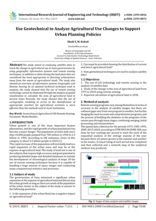
  • 1. International Research Journal of Engineering and Technology (IRJET) e-ISSN: 2395-0056 Volume: 06 Issue: 03 | Mar 2019 www.irjet.net p-ISSN: 2395-0072 © 2019, IRJET | Impact Factor value: 7.211 | ISO 9001:2008 Certified Journal | Page 7638 Use Geotechnical to Analyze Agricultural Use Changes to Support Urban Planning Policies Shadi Z. M. Kuhail skouhail@ucas.edu.ps Master of Geography and GIS Coordinator of GIS Specialization Lecturer in Information Technology Department University College of Applied Sciences - Gaza. Palestine ------------------------------------------------------------------------------------------------------------------------------------------ Abstract:The study aimed at analyzing satellite data to track the change in agricultural use in Gaza governorates by using geographic information systems and remote sensing techniques, in addition to determining the land plots that are considered the most appropriate in directing urbanization away from the waste of agricultural lands. The study also showed an overview of information systems Geographic and Remote Sensing As an optimal technical technique used in analysis, the study showed that the use of remote sensing technology cannot be dispensedthroughtheanalysisofspatial visualization to calculate the area of agricultural land in ancient times Recently, the study showed that the use of cartographic modeling to arrive at the identification of appropriate vouchers for agricultural activities is more efficient than the methods used in local institutions. Key Words: Geotechnical-Agricultural-GIS-Remote Sensing- Farmland- Model Builder. 1.INTRODUCTION Urban growth is one of the most important human phenomena, and the rapid growth of urban populations has become a major danger. The population of cities with more than 10,000 people jumped from 700 million in 1950 to 2.3 billion in 1990. According to UN estimates, Cities of this category to about 5.5 billion people in 2025.(1) This rapid increase of the population will inevitablyleadtoa rapid expansion of the urban mass and may be at the expense of agricultural land. The study of land use is one of the subjects that require high accuracyandgreatpotential in producing detailed maps and detailed databases to include the development of chronological analysis of maps. Of the use of remote sensing techniques because it is capable of handling a huge amount of space images and conducting many computerized statistics and processes. 1.1 Subject of study The governorates of Gaza witnessed a significant urban expansion at the expense of agriculturallandanddidnotstop the urban growth as long as there are needsofthepopulation of the urban cluster so the subject of the study in answer to the following questions: 1. Is the expansion of the urban block has a negative impact on agricultural land? 2. Can maps be provided showing the distribution of current and future agricultural land? 3. How geotechnical techniques are used to analyze satellite data? 1.2 Objectives 1. The use of GIS technology and remote sensing in the analysis of satellite data 2. Study of the change in the area of agricultural land from 1975 to 2018 using remote sensing. 3. Expected calculation of agricultural land in 2030. 2. Method of analysis Remotesensingprogramsvaryamongthemselvesintermsof accuracy in the analysis of satellite images, but there are software gaps vary from one program to another, but Eardas Imagingthemostaccurateandcomprehensiveprograms,and the process of building the database in the programs of the sensor pass through many stages, combining,merging,initial processing and interpretation. The spatial data collection for the periods 1975-1985-1995, 2005-2015-2018, according toUTM-WGS84ZONE36N, was done by four readings per period to meet the need of the sequential analysis of the average seasons of the year because there are plants grown in the summer and another in the winter, A visual rating of each period was completed and then collected and a network map of the analytical medium was produced. Fig -1: Stages of data analysis and satellite images
  • 2. International Research Journal of Engineering and Technology (IRJET) e-ISSN: 2395-0056 Volume: 06 Issue: 03 | Mar 2019 www.irjet.net p-ISSN: 2395-0072 © 2019, IRJET | Impact Factor value: 7.211 | ISO 9001:2008 Certified Journal | Page 7639 The reflected radiation from agricultural land is influenced by several factors, the most important of which is the roughness and softness of the vegetation cover and the materials it contains. The radiation reflected from the green trees is different from the radiation reflection of dry trees. Therefore, it is possible to estimate the area of agricultural land and tree density (2). Analysis of chlorophyll in the water, which reflectsthecycle of amphibian plants that affect the nature of the reflected radiation. Water containing large quantities of suspended sediments reflects visible wave radiation more than pure water. Here in the Gaza Strip, In satellite images accurately when applying the average analytical approach to classifications by seasons of the year. Table-1: Results of analysis of satellite images of Farmland Governorate Gaza km2 year RafahKhanYounesMiddleGazaNorth 12.0133.3622.3829.4130.161975 11.1830.6723.0826.0320.721985 11.1528.4121.7624.1615.381995 9.3223.8418.2219.1811.222005 17.5728.0819.2013.379.512015 17.3129.1313.3713.109.662018 The table shows that there is a decline in the area of agricultural land from 1975 to 2018 for urban use. It is also evident that there is an increase in agricultural land in Khan Younis and Rafah from 2005 to 2015 due to the withdrawal of the Israeli occupation from the settlements in the Gaza Strip. A slight increase in the agricultural area from 2015 to 2018 at the level of most governorates in view of the encouragement of the Ministry of Agriculture on agriculture and the identification of crops for self-sufficiency.(3). Chart -1: Development of the agricultural land area 3. data analysis The results of the analysis are used for theyears 1975-1985- 1995-2005-2015 using the output data produced by the Markov chain analysis within the IDRISI environment. An application model was implemented for the first half of 2015. This model uses the results of the years precedingthis model. Which shows the expectation and change in the expansion of the urban mass, the standard KAPA model is used to test the validity of this data. If the reliability ratio is more than 70% here we acknowledge its validity. If the KAPA model is a measurement of less than 70% correct.(4) Fig -2: classification and analysis of satellite images In terms of the data of this research, the measurement of the Kappa IDRISI model using a validated tool was given a kaba level of 0.9314, a kappa for the information used 0.8229, a kappa for the cell level of 0.8325 and a kappa for the class accuracy of 0.8951, all above 0.7. This gives a high analytical index. Forecasts for 2030.(5) Table-2: Classification of agricultural use by seasons / km2 Year January April July October average 1975 144.25 137.56 122.32 105.26 127.35 1985 118.85 116.56 112.21 98.99 111.66 1995 113.86 110.97 98.59 79.99 100.87 2005 91.26 89.19 82.69 63.99 81.79 2018 101.86 100.19 80.26 68.71 87.75
  • 3. International Research Journal of Engineering and Technology (IRJET) e-ISSN: 2395-0056 Volume: 06 Issue: 03 | Mar 2019 www.irjet.net p-ISSN: 2395-0072 © 2019, IRJET | Impact Factor value: 7.211 | ISO 9001:2008 Certified Journal | Page 7640 4. Predict Table-3: Expected results 2030 / km2 Governorate Gaza 2030 RafahKhanYounesMiddleGazaNorthType 26.1743.4937.8134.5036.60Urban 9.1513.471.455.462.68agricultural The above table shows that there are expectations of a further decline in agricultural land according to the projections of 2030. It is also noted that there are provinces where agricultural lands may be exposed to extinction, such as the northern and central governorates.(6) 5. Use cartographic modeling to reduce waste of agricultural land. One of the basic requirements for building the cartographic model is the formulation of criteria or the conditions necessary to evaluate the land for the future development process, which ensures the fulfillment of the needs and the maintenance of the standard of land ownership. The use of GIS technology here in determining the areas that can be employed as new residential areas and according to special criteria in the region.(7) In this study, criteria were carefully formulated after reviewing previous studies, field visits, comparison with international standards, conducting a series of personal interviews and working with correspondents.(8) Fig -3: Results of applying the study criteria 5.1: Building Model Builder. After building the hierarchical model and defining the criteria, types, levels and degree of weight, the cartographic model was built in the ArcGIS and through the structural model, which is based on the simplification of complex problems and the overlap of the data and their spatial and descriptive relationships. Therefore, this model is formulated to simplify the problem and formulate the method of solving it through So-calledgraphical layoutofthe stages of work.(9) Fig -4: Modeling and charting 5.2: Analysis proposed sites After setting the criteria for deliberate guidance for the agricultural and urban growth of the Gaza governorates and after applying the weights, the process concluded to devise the appropriate sites as follows.(10) Fig -5: Map relevance 2030
  • 4. International Research Journal of Engineering and Technology (IRJET) e-ISSN: 2395-0056 Volume: 06 Issue: 03 | Mar 2019 www.irjet.net p-ISSN: 2395-0072 © 2019, IRJET | Impact Factor value: 7.211 | ISO 9001:2008 Certified Journal | Page 7641 6. CONCLUSIONS 6.1.Gaza Strip is a rapidly growing population, one of the highest in the world, and this is the main reasonfortherapid decline of agricultural land. 6.2.The study showed that thereisa verystrongrelationship between the expansion of the urban mass and the steady increase in the number of population in the Gaza Governorates. This is the main determinant of the planned agricultural planning. 6.3.The study succeeded in preparing a detailed study to show the evolution and change in the spatial distribution of land use maps since 1975. 6.4.The study showed the ability of GIS and remote sensing technology to study the evolution of agricultural and urban land area through the production of accurate maps. 6.5.The use of analysis according to the Markov Applied Mathematical Chain and the confirmation of results according to this Kaba accuracy index gives accurate results for relying on the results of the research in government decision making. 6.6.The use of cartographic modeling to determine the future agricultural and urban growth areas is more efficient than the methods used in local institutions, optimizing the use of resources, achieving the highest returns and minimizing land losses. 6.7.The process of relying on the distribution of the questionnaire to the planning and GIS specialists is one of the best ways to obtain the weights of the planning standards accurately. 7. Recommendations study 7.1. Adopt a strategy to increase the absorptive capacity of existing urban centers by encouraging the vertical expansion of buildings. 7.2. Focus on public awareness to realize the importance of commitment to urban planning and conservation of agricultural land according to the provisions of the structural plans and interest in popular participation in the preparation of future plans. 7.3. Use of geographic information systems and remote sensing in all local institutions because it has proved successful in the preparation of spatial databases REFERENCES: 1. United Nations (World Urbanization Prospects) New York 2014. 2. Ir Yannick Curnel (Basic principles of remote sensing) Dec 2014 - Walloon Agricultural Research Centre (CRA-W)- Agriculture and natural environment Department-p21. 3. Palestinian Sector Plan (Urban Development Sector) 2010-2020 -p11 4. Canada Centre for Remote Sensing(Fundamentals of Remote Sensing)2016 5..Werle D (Radar Remote Sensing - A Training Manual) . (1988 and 1992), 193p, 75 35mm slides, Dendron Resource Surveys Ltd, Ottawa, Ontario, Canada, ISBN 0- 9693733-0-9 6. Oliver, C. & S. Quegan (Understandingsyntheticaperture radar images) 1998, 479 p., Artech House, Norwood, MA, USA, ISBN 089006850X 7. Sohaib abu jaeab (Future Urban Development in Khan Yunis Governorate in light of the conservation of environmental resources using GIS.RS)2012. Master of Islamic University in Gaza Palestine .p199. 8. Ministry of Works and Human Settlement(Spatial Planning Standards)June 2017.p9. 9. Isri Company (ModelBuilder - Creating Tools Tutorial) Copyright © 1995-2010 Esri. All rights reserved. 10. Shadi Kuhail (Impact of the Urban Growth On The Land Ownership In Gaza Governorates, Using GIS and Remote Sensing Technology)2013. Master of Islamic University in Gaza Palestine .p190.